


Alter nautischer Chart von Hongkong von Belcher, 1953: Victoria Harbour, Kowloon-Halbinsel
Das Sammlerangebot
Wählen Sie zwei berechtigte Werke und erhalten Sie auf beide 20 % Rabatt. Wählen Sie drei, und das günstigste ist kostenlos – eine maximale Ersparnis von 33 %.
Kombinieren Sie berechtigte Standardkarten und Kunstdrucke nach Belieben. Kein Code erforderlich; das Angebot wird an der Kasse automatisch angewendet.
Standardmäßige Konfigurationen nach Maßanfertigung sind inbegriffen. Maßgeschneiderte Größen, personalisierte Entwürfe und Auftragsarbeiten sind ausgeschlossen.
Benötigen Sie die Lieferung an unterschiedliche Adressen? Kontaktieren Sie uns vor der Bestellung.Das Sammlerangebot
Wählen Sie zwei berechtigte Werke und erhalten Sie auf beide 20 % Rabatt. Wählen Sie drei, und das günstigste ist kostenlos – eine maximale Ersparnis von 33 %.
Kombinieren Sie berechtigte Standardkarten und Kunstdrucke nach Belieben. Kein Code erforderlich; das Angebot wird an der Kasse automatisch angewendet.
Standardmäßige Konfigurationen nach Maßanfertigung sind inbegriffen. Maßgeschneiderte Größen, personalisierte Entwürfe und Auftragsarbeiten sind ausgeschlossen.
Benötigen Sie die Lieferung an unterschiedliche Adressen? Kontaktieren Sie uns vor der Bestellung. In London gestaltet Hergestellt in Australia
In London gestaltet • Hergestellt in Australia
In London gestaltet Hergestellt in Australia
In London gestaltet • Hergestellt in Australia

Aus der Originalkarte von 1843 restauriert und in Museumsqualität gedruckt. Die Geschichte hinter dieser Karte lesen
Choose your size
Choose your finish


(Mehr Infos)
Geschenkmitteilung & individuelle Ausführung

Wenn Sie eine Geschenkmitteilung oder eine Ausführung (Puzzle, Aluminiumplatte usw.) hinzufügen möchten, die hier nicht verfügbar ist, geben Sie dies bitte in der "Bestellnotiz" beim Checkout an.
Jede Bestellung wird individuell angefertigt. Wenn Sie die Größe leicht anpassen oder auf einem ungewöhnlichen Material drucken lassen möchten, lassen Sie es uns einfach wissen. Wir haben im Laufe der Jahre Tausende von individuellen Bestellungen bearbeitet, daher gibt es (fast) nichts, was wir nicht bewältigen können.
Sie können uns auch kontaktieren, bevor Sie bestellen, wenn Sie möchten!

- Lokal gefertigt. Sicher geliefert
- Keine Zölle oder versteckten Gebühren
- Hilfe nötig? Rufen Sie uns an oder WhatsApp schreiben
Own a piece of history
8,000+ five-star reviews


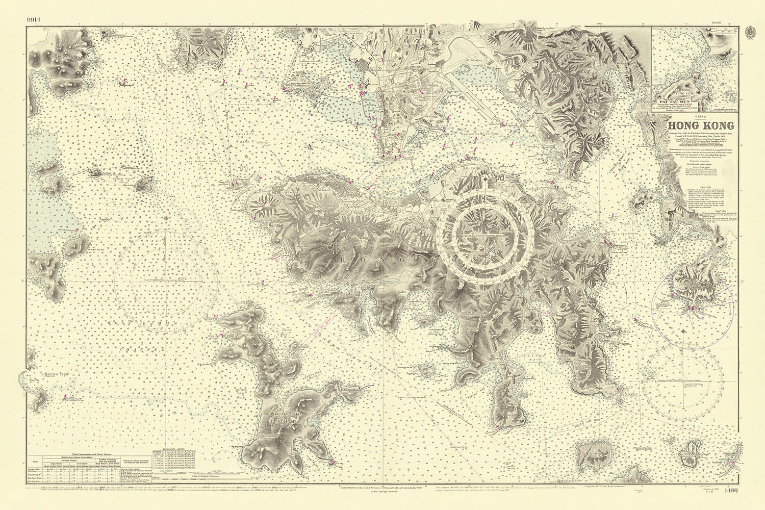
Betreten Sie die maritime Welt des 19. und 20. Jahrhunderts in Hongkong mit dieser außergewöhnlichen nautischen Karte der britischen Admiralität, einem Meisterwerk,...
WeiterlesenBetreten Sie die maritime Welt des 19. und 20. Jahrhunderts in Hongkong mit dieser außergewöhnlichen nautischen Karte der britischen Admiralität, einem Meisterwerk, das die Entwicklung eines der berühmtesten Häfen der Welt dokumentiert. Diese Karte, die 1841 erstmals von Kapitän Sir Edward Belcher vermessen und bis 1953 von Generationen von Vermessern der Royal Navy aktualisiert wurde, ist ein lebendiges Zeugnis der Ära, als sich Hongkong von einem strategischen Militärposten in einen geschäftigen internationalen Hafen verwandelte. Der Hauptfokus der Karte liegt auf den komplexen Wasserwegen rund um die Hongkong-Insel, die Kowloon-Halbinsel und ihre benachbarten Inselchen - Regionen, die zum pulsierenden Herzen des britischen Kolonialhandels in Ostasien werden sollten.
Was diese Karte wirklich fesselnd macht, ist der Reichtum an hydrographischen Daten, die sorgfältig dargestellt sind, um Seefahrer durch diese wichtigen Schifffahrtswege zu leiten. Die Karte ist geschmückt mit dichten Anordnungen von Messungen - Zahlen in Faden - die mühsam aufgezeichnet wurden, um Wassertiefen und sichere Durchfahrten zu kartieren. Navigationshilfen sind reichlich vorhanden, von prominenten Kompassrosen, die die magnetische Variation anzeigen, bis hin zu detaillierten Gezeitennotizen und Tabellen, die alle elegant in das Design der Karte integriert sind. Diese Infografiken waren nicht nur dekorativ; sie waren essentielle Werkzeuge für Seefahrer, die die kritischen Informationen bereitstellten, die benötigt wurden, um die oft tückischen Gewässer des Südchinesischen Meeres zu navigieren.
Über die navigationalen Präzision hinaus bietet die Karte einen faszinierenden Einblick in die sich entwickelnde Landschaft und Infrastruktur des kolonialen Hongkongs. Die Küstentopografie wird mit sorgfältiger Aufmerksamkeit dargestellt, wobei hohe Punkte, Vorgebirge und Binnenhügel markiert sind, die als wichtige Referenzpunkte für ankommende Schiffe dienten. Die Karte hebt auch die wachsende Komplexität des Hafens selbst hervor, mit Ankerplätzen, Piers und Leuchttürmen, die klar beschriftet sind - Beweise für die rasante Entwicklung Hongkongs als globales Handelszentrum. Jedes Update der Karte, von den Vermessungen von Field und Moore im späten 19. Jahrhundert bis zu den Nachkriegsberichtigungen, spiegelt die fortlaufende Transformation der Stadt und das Engagement der britischen Admiralität für kartografische Exzellenz wider.
Die Kunstfertigkeit und Genauigkeit dieser Karte sind emblematisch für die Kartographie-Tradition der britischen Admiralität, die für ihre strengen Standards und innovativen Techniken bekannt ist. Sir Edward Belcher, der ursprüngliche Vermesser, war eine legendäre Figur in der maritimen Erkundung, dessen Karriere sich über den Globus von der Arktis bis zum Pazifik erstreckte. Seine Nachfolger, darunter Field, Moore, Smyth und Monro, brachten jeweils ihre eigene Expertise ein, trugen neue Daten bei und verfeinerten die Karte über mehr als ein Jahrhundert. Das Ergebnis ist ein lebendiges Dokument - Teil Navigationshilfe, Teil historische Aufzeichnung - das das dynamische Zusammenspiel zwischen Imperium, Handel und Geografie einfängt.
Für Sammler und Kenner ist diese Karte weit mehr als ein Navigationswerkzeug; sie ist ein Fenster in das geopolitische Drama und das maritime Erbe Ostasiens. Die akribischen Details der Karte, die geschichtsträchtige Provenienz und die historische Resonanz machen sie zu einem herausragenden Stück für jede Sammlung. Ob als Mittelpunkt ausgestellt oder für ihren Reichtum an Informationen studiert, bietet sie eine seltene Gelegenheit, die Konturen der Vergangenheit Hongkongs nachzuvollziehen, geleitet von den Händen einiger der angesehensten maritimen Vermesser Großbritanniens.
Bemerkenswerte Orte auf dieser Karte
- Hongkong-Insel (Hauptfokus der Karte)
- Kowloon-Halbinsel (nördlich der Hongkong-Insel)
- Victoria Harbour (zentrale Wasserstraße zwischen der Hongkong-Insel und Kowloon)
- Possession Point (Standort der britischen Landung 1841)
- Lamma Island (im Südwesten der Hongkong-Insel)
- Grüne Insel und Stonecutters Island (kleinere Inseln in der Nähe des Haupthafens)
- Aberdeen (ein Hafenbereich auf der Südseite von Hongkong)
- Lei Yue Mun (östlicher Zugang zum Victoria Harbour)
- Tsing Yi Island (nordwestlich von Hongkong)
- Verschiedene Küstenvorsprünge, Buchten und Ankerplätze, die für die Navigation gekennzeichnet sind
Bemerkenswerte Merkmale & Wahrzeichen
- Detaillierte Tiefenmessungen (Wassertiefen in Faden) im gesamten Hafen von Hongkong und in angrenzenden Gewässern
- Mehrere Kompassrosen, die die magnetische Variation für navigationsbezogene Referenzen anzeigen
- Markierte Gezeitenhinweise und -tabellen für Seefahrer
- Küstengeographie mit hochgelegenen Punkten und Hügeln, die im Landesinneren angezeigt werden
- Leuchttürme, Bojen und andere Navigationshilfen entlang wichtiger Kanäle und Zugänge gekennzeichnet
- Deutlich abgegrenzte Hafenbereiche, einschließlich Ankerplätze und sichere Wasserzonen
- Umrisse von Hongkong, der Kowloon-Halbinsel und nahegelegenen Inseln
- Notizen zu bedeutenden Vermessungsjahren und den Namen der Vermesser im Kartentitel
- Hafeninfrastruktur wie Piers, Docks oder Kaianlagen entlang der Küste angezeigt
- Britische Admiralitätskartennummer und Veröffentlichungs-/Korrekturdaten im Kartenrand
Historischer und gestalterischer Kontext
- Erstmals 1843 von der britischen Admiralität veröffentlicht, basierend auf Vermessungen von Sir Edward Belcher und später von anderen Vermessern der Royal Navy aktualisiert. Die Karte zeigt Hongkong im Jahr 1953.
- Kontinuierlich aktualisiert durch Zeiten bedeutender politischer und wirtschaftlicher Veränderungen, einschließlich der Opiumkriege, der britischen kolonialen Expansion, der japanischen Besatzung während des Zweiten Weltkriegs und der Nachkriegszeit
- Nautische Karte (Seekarte), die sich auf Hongkong und seine Küstengewässer konzentriert und für die maritime Navigation entworfen wurde
- Stellt die erste umfassende britische Vermessung von Hongkong dar, die als grundlegende nautische Referenz für Seefahrer dient
- Spiegelt die Transformation der Region zu einem wichtigen internationalen Hafen unter britischer Herrschaft wider
- Detaillierte hydrographische Karte mit Tiefenmessungen in Faden, Kompassrosen, Gezeiten tabellen und Küstenmerkmalen
- Jede Aktualisierung spiegelt die fortlaufende Transformation der Stadt und das Engagement der britischen Admiralität für kartografische Exzellenz wider
Bitte überprüfen Sie die Bilder, um sicherzustellen, dass eine bestimmte Stadt oder ein bestimmter Ort auf dieser Karte angezeigt wird. Sie können uns auch kontaktieren und fragen, ob wir die Karte für Sie überprüfen.
Diese Karte sieht in jeder Größe großartig aus, aber ich empfehle immer, eine größere Größe zu wählen, wenn Sie Platz haben. So können Sie alle Details leicht erkennen.
Diese Karte sieht in Größen bis zu 100in (250cm) erstaunlich aus. Wenn Sie nach einer größeren Karte suchen, bitte kontaktieren Sie uns.
Bitte beachten Sie: Die Beschriftungen auf dieser Karte sind schwer zu lesen, wenn Sie eine Karte bestellen, die 36in (90cm) oder kleiner ist. Die Karte ist immer noch sehr attraktiv, aber wenn Sie die Karte leicht lesen möchten, kaufen Sie bitte eine größere Größe.
Das Modell in den Listing-Bildern hält die 24x36in (60x90cm) Version dieser Karte.
Das fünfte Listing-Bild zeigt ein Beispiel meines Personalisierungsservice für Karten.
Wenn Sie nach etwas etwas anderem suchen, schauen Sie sich meine Sammlung der besten alten Karten an, um zu sehen, ob etwas anderes Ihr Interesse weckt.
Bitte kontaktieren Sie mich, um zu überprüfen, ob ein bestimmter Standort, ein Wahrzeichen oder ein Merkmal auf dieser Karte angezeigt wird.
Dies wäre ein wunderbares Geschenk zum Geburtstag, Weihnachten, Vatertag, Abschied von der Arbeit, Jubiläum oder Einweihung für jemanden aus den Gebieten, die von dieser Karte abgedeckt werden.
Diese Karte ist als Giclée-Druck auf säurefreiem, archivfestem mattem Papier erhältlich, oder Sie können sie gerahmt kaufen. Der Rahmen ist ein schöner, einfacher schwarzer Rahmen, der zu den meisten Ästhetiken passt. Bitte kontaktieren Sie mich, wenn Sie eine andere Rahmenfarbe oder -material wünschen. Meine Rahmen sind mit superklarem museumsglänzendem Acryl (Plexiglas/Acrylit) verglast, das erheblich weniger reflektierend ist als Glas, sicherer und immer in perfektem Zustand ankommt.
This map is also available as a float framed canvas, sometimes known as a shadow gap framed canvas or canvas floater. The map is printed on artist's cotton canvas and then stretched over a handmade box frame. We then "float" the canvas inside a wooden frame, which is available in a range of colours (black, dark brown, oak, antique gold and white). This is a wonderful way to present a map without glazing in front. See some examples of float framed canvas maps and explore the differences between my different finishes.
For something truly unique, this map is also available in "Unique 3D", our trademarked process that dramatically transforms the map so that it has a wonderful sense of depth. We combine the original map with detailed topography and elevation data, so that mountains and the terrain really "pop". For more info and examples of 3D maps, check my Unique 3D page.
Betreten Sie die maritime Welt des 19. und 20. Jahrhunderts in Hongkong mit dieser außergewöhnlichen nautischen Karte der britischen Admiralität, einem Meisterwerk, das die Entwicklung eines der berühmtesten Häfen der Welt dokumentiert. Diese Karte, die 1841 erstmals von Kapitän Sir Edward Belcher vermessen und bis 1953 von Generationen von Vermessern der Royal Navy aktualisiert wurde, ist ein lebendiges Zeugnis der Ära, als sich Hongkong von einem strategischen Militärposten in einen geschäftigen internationalen Hafen verwandelte. Der Hauptfokus der Karte liegt auf den komplexen Wasserwegen rund um die Hongkong-Insel, die Kowloon-Halbinsel und ihre benachbarten Inselchen - Regionen, die zum pulsierenden Herzen des britischen Kolonialhandels in Ostasien werden sollten.
Was diese Karte wirklich fesselnd macht, ist der Reichtum an hydrographischen Daten, die sorgfältig dargestellt sind, um Seefahrer durch diese wichtigen Schifffahrtswege zu leiten. Die Karte ist geschmückt mit dichten Anordnungen von Messungen - Zahlen in Faden - die mühsam aufgezeichnet wurden, um Wassertiefen und sichere Durchfahrten zu kartieren. Navigationshilfen sind reichlich vorhanden, von prominenten Kompassrosen, die die magnetische Variation anzeigen, bis hin zu detaillierten Gezeitennotizen und Tabellen, die alle elegant in das Design der Karte integriert sind. Diese Infografiken waren nicht nur dekorativ; sie waren essentielle Werkzeuge für Seefahrer, die die kritischen Informationen bereitstellten, die benötigt wurden, um die oft tückischen Gewässer des Südchinesischen Meeres zu navigieren.
Über die navigationalen Präzision hinaus bietet die Karte einen faszinierenden Einblick in die sich entwickelnde Landschaft und Infrastruktur des kolonialen Hongkongs. Die Küstentopografie wird mit sorgfältiger Aufmerksamkeit dargestellt, wobei hohe Punkte, Vorgebirge und Binnenhügel markiert sind, die als wichtige Referenzpunkte für ankommende Schiffe dienten. Die Karte hebt auch die wachsende Komplexität des Hafens selbst hervor, mit Ankerplätzen, Piers und Leuchttürmen, die klar beschriftet sind - Beweise für die rasante Entwicklung Hongkongs als globales Handelszentrum. Jedes Update der Karte, von den Vermessungen von Field und Moore im späten 19. Jahrhundert bis zu den Nachkriegsberichtigungen, spiegelt die fortlaufende Transformation der Stadt und das Engagement der britischen Admiralität für kartografische Exzellenz wider.
Die Kunstfertigkeit und Genauigkeit dieser Karte sind emblematisch für die Kartographie-Tradition der britischen Admiralität, die für ihre strengen Standards und innovativen Techniken bekannt ist. Sir Edward Belcher, der ursprüngliche Vermesser, war eine legendäre Figur in der maritimen Erkundung, dessen Karriere sich über den Globus von der Arktis bis zum Pazifik erstreckte. Seine Nachfolger, darunter Field, Moore, Smyth und Monro, brachten jeweils ihre eigene Expertise ein, trugen neue Daten bei und verfeinerten die Karte über mehr als ein Jahrhundert. Das Ergebnis ist ein lebendiges Dokument - Teil Navigationshilfe, Teil historische Aufzeichnung - das das dynamische Zusammenspiel zwischen Imperium, Handel und Geografie einfängt.
Für Sammler und Kenner ist diese Karte weit mehr als ein Navigationswerkzeug; sie ist ein Fenster in das geopolitische Drama und das maritime Erbe Ostasiens. Die akribischen Details der Karte, die geschichtsträchtige Provenienz und die historische Resonanz machen sie zu einem herausragenden Stück für jede Sammlung. Ob als Mittelpunkt ausgestellt oder für ihren Reichtum an Informationen studiert, bietet sie eine seltene Gelegenheit, die Konturen der Vergangenheit Hongkongs nachzuvollziehen, geleitet von den Händen einiger der angesehensten maritimen Vermesser Großbritanniens.
Bemerkenswerte Orte auf dieser Karte
- Hongkong-Insel (Hauptfokus der Karte)
- Kowloon-Halbinsel (nördlich der Hongkong-Insel)
- Victoria Harbour (zentrale Wasserstraße zwischen der Hongkong-Insel und Kowloon)
- Possession Point (Standort der britischen Landung 1841)
- Lamma Island (im Südwesten der Hongkong-Insel)
- Grüne Insel und Stonecutters Island (kleinere Inseln in der Nähe des Haupthafens)
- Aberdeen (ein Hafenbereich auf der Südseite von Hongkong)
- Lei Yue Mun (östlicher Zugang zum Victoria Harbour)
- Tsing Yi Island (nordwestlich von Hongkong)
- Verschiedene Küstenvorsprünge, Buchten und Ankerplätze, die für die Navigation gekennzeichnet sind
Bemerkenswerte Merkmale & Wahrzeichen
- Detaillierte Tiefenmessungen (Wassertiefen in Faden) im gesamten Hafen von Hongkong und in angrenzenden Gewässern
- Mehrere Kompassrosen, die die magnetische Variation für navigationsbezogene Referenzen anzeigen
- Markierte Gezeitenhinweise und -tabellen für Seefahrer
- Küstengeographie mit hochgelegenen Punkten und Hügeln, die im Landesinneren angezeigt werden
- Leuchttürme, Bojen und andere Navigationshilfen entlang wichtiger Kanäle und Zugänge gekennzeichnet
- Deutlich abgegrenzte Hafenbereiche, einschließlich Ankerplätze und sichere Wasserzonen
- Umrisse von Hongkong, der Kowloon-Halbinsel und nahegelegenen Inseln
- Notizen zu bedeutenden Vermessungsjahren und den Namen der Vermesser im Kartentitel
- Hafeninfrastruktur wie Piers, Docks oder Kaianlagen entlang der Küste angezeigt
- Britische Admiralitätskartennummer und Veröffentlichungs-/Korrekturdaten im Kartenrand
Historischer und gestalterischer Kontext
- Erstmals 1843 von der britischen Admiralität veröffentlicht, basierend auf Vermessungen von Sir Edward Belcher und später von anderen Vermessern der Royal Navy aktualisiert. Die Karte zeigt Hongkong im Jahr 1953.
- Kontinuierlich aktualisiert durch Zeiten bedeutender politischer und wirtschaftlicher Veränderungen, einschließlich der Opiumkriege, der britischen kolonialen Expansion, der japanischen Besatzung während des Zweiten Weltkriegs und der Nachkriegszeit
- Nautische Karte (Seekarte), die sich auf Hongkong und seine Küstengewässer konzentriert und für die maritime Navigation entworfen wurde
- Stellt die erste umfassende britische Vermessung von Hongkong dar, die als grundlegende nautische Referenz für Seefahrer dient
- Spiegelt die Transformation der Region zu einem wichtigen internationalen Hafen unter britischer Herrschaft wider
- Detaillierte hydrographische Karte mit Tiefenmessungen in Faden, Kompassrosen, Gezeiten tabellen und Küstenmerkmalen
- Jede Aktualisierung spiegelt die fortlaufende Transformation der Stadt und das Engagement der britischen Admiralität für kartografische Exzellenz wider
Bitte überprüfen Sie die Bilder, um sicherzustellen, dass eine bestimmte Stadt oder ein bestimmter Ort auf dieser Karte angezeigt wird. Sie können uns auch kontaktieren und fragen, ob wir die Karte für Sie überprüfen.
Diese Karte sieht in jeder Größe großartig aus, aber ich empfehle immer, eine größere Größe zu wählen, wenn Sie Platz haben. So können Sie alle Details leicht erkennen.
Diese Karte sieht in Größen bis zu 100in (250cm) erstaunlich aus. Wenn Sie nach einer größeren Karte suchen, bitte kontaktieren Sie uns.
Bitte beachten Sie: Die Beschriftungen auf dieser Karte sind schwer zu lesen, wenn Sie eine Karte bestellen, die 36in (90cm) oder kleiner ist. Die Karte ist immer noch sehr attraktiv, aber wenn Sie die Karte leicht lesen möchten, kaufen Sie bitte eine größere Größe.
Das Modell in den Listing-Bildern hält die 24x36in (60x90cm) Version dieser Karte.
Das fünfte Listing-Bild zeigt ein Beispiel meines Personalisierungsservice für Karten.
Wenn Sie nach etwas etwas anderem suchen, schauen Sie sich meine Sammlung der besten alten Karten an, um zu sehen, ob etwas anderes Ihr Interesse weckt.
Bitte kontaktieren Sie mich, um zu überprüfen, ob ein bestimmter Standort, ein Wahrzeichen oder ein Merkmal auf dieser Karte angezeigt wird.
Dies wäre ein wunderbares Geschenk zum Geburtstag, Weihnachten, Vatertag, Abschied von der Arbeit, Jubiläum oder Einweihung für jemanden aus den Gebieten, die von dieser Karte abgedeckt werden.
Diese Karte ist als Giclée-Druck auf säurefreiem, archivfestem mattem Papier erhältlich, oder Sie können sie gerahmt kaufen. Der Rahmen ist ein schöner, einfacher schwarzer Rahmen, der zu den meisten Ästhetiken passt. Bitte kontaktieren Sie mich, wenn Sie eine andere Rahmenfarbe oder -material wünschen. Meine Rahmen sind mit superklarem museumsglänzendem Acryl (Plexiglas/Acrylit) verglast, das erheblich weniger reflektierend ist als Glas, sicherer und immer in perfektem Zustand ankommt.
This map is also available as a float framed canvas, sometimes known as a shadow gap framed canvas or canvas floater. The map is printed on artist's cotton canvas and then stretched over a handmade box frame. We then "float" the canvas inside a wooden frame, which is available in a range of colours (black, dark brown, oak, antique gold and white). This is a wonderful way to present a map without glazing in front. See some examples of float framed canvas maps and explore the differences between my different finishes.
For something truly unique, this map is also available in "Unique 3D", our trademarked process that dramatically transforms the map so that it has a wonderful sense of depth. We combine the original map with detailed topography and elevation data, so that mountains and the terrain really "pop". For more info and examples of 3D maps, check my Unique 3D page.
Many of our maps and art prints are chosen as thoughtful gifts for homes, offices, studies and meaningful places.
Choose a framed option for the easiest ready-to-hang gift, or choose an unframed print if the recipient may prefer to select their own frame.
We make orders locally in 23 countries around the world, so gifts can often be produced close to the recipient. This helps them arrive faster, travel more safely, and avoid customs or import duty surprises.
- We can deliver directly to the recipient
- Framed pieces arrive ready to hang
- Unframed prints are carefully packed in a strong protective tube
- Almost every order is made locally, for faster, safer gifting
- 90-day returns give the recipient time to decide
If you are not sure what to choose, please contact us. We can help you pick the right map, size, finish or delivery option.
Für die meisten Bestellungen beträgt die Lieferzeit etwa 3 Werktage. Personalisierte und maßgeschneiderte Produkte benötigen länger, da ich die Personalisierung durchführen und sie Ihnen zur Genehmigung zusenden muss, was normalerweise 1 oder 2 Tage dauert.
Bitte beachten Sie, dass sehr große gerahmte Bestellungen in der Regel länger für die Herstellung und Lieferung benötigen.
Wenn Sie möchten, dass Ihre Bestellung bis zu einem bestimmten Datum ankommt, bitte kontaktieren Sie mich, bevor Sie bestellen, damit wir den besten Weg finden können, um sicherzustellen, dass Sie Ihre Bestellung rechtzeitig erhalten.
Ich drucke und rahme Karten und Kunstwerke in 23 Ländern weltweit. Das bedeutet, dass Ihre Bestellung lokal gefertigt wird, was die Lieferzeit verkürzt und sicherstellt, dass sie während der Lieferung nicht beschädigt wird. Sie zahlen nie Zoll oder Einfuhrgebühren, und wir stoßen weniger CO2 in die Luft aus.
Alle meine Karten und Kunstdrucke sind gut verpackt und werden in einem robusten Rohr versendet, wenn sie ungerahmt sind, oder von Schaum umgeben, wenn sie gerahmt sind.
Ich versuche, alle Bestellungen innerhalb von 1 oder 2 Tagen nach Erhalt Ihrer Bestellung zu versenden, obwohl einige Produkte (wie Gesichtsmasken, Tassen und Tragetaschen) länger zur Herstellung benötigen können.
Wenn Sie Express-Lieferung an der Kasse auswählen, priorisieren wir Ihre Bestellung und versenden sie per 1-Tages-Kurier (Fedex, DHL, UPS, Parcelforce).
Nächster Tag Lieferung ist auch in einigen Ländern verfügbar (USA, UK, Singapur, VAE), aber bitte versuchen Sie, früh am Tag zu bestellen, damit wir es rechtzeitig versenden können.
Lesen Sie meinen vollständigen Leitfaden zur Lieferung und lokalen Produktion
Mein Standardrahmen ist ein Galerie-Stil-Rahmen aus schwarzem Eschenholz. Er ist einfach und sieht ziemlich modern aus. Mein Standardrahmen ist etwa 20 mm (0,8 Zoll) breit.
Ich verwende super-klares Acryl (Plexiglas/Acrylt) für das Glas des Rahmens. Es ist leichter und sicherer als Glas – und es sieht besser aus, da die Reflexion geringer ist.
Sechs Standardrahmenfarben sind kostenlos erhältlich (schwarz, dunkelbraun, dunkelgrau, Eiche, weiß und antikgold).
Die meisten Karten, Kunstwerke und Illustrationen sind auch als gerahmte Leinwand erhältlich. Wir verwenden matte (nicht glänzende) Baumwollleinwand, spannen sie über einen nachhaltig beschafften Buchenrahmen und 'schweben' dann das Stück innerhalb eines Holzrahmens. Das Endergebnis ist ziemlich schön, und es gibt keine Verglasung, die im Weg ist.
Alle Rahmen werden "bereit zum Aufhängen" geliefert, entweder mit einer Schnur oder Halterungen auf der Rückseite. Sehr große Rahmen haben schwere Aufhängeplatten und/oder eine Montageschiene. Wenn Sie Fragen haben, können Sie bitte Kontakt aufnehmen.
Sehen Sie sich einige Beispiele meiner gerahmten Karten und gerahmten Leinwandkarten an.
Alternativ kann ich auch alte Karten und Kunstwerke auf Leinwand, Schaumstoffplatten, Baumwollrag und andere Materialien liefern.
Wenn Sie Ihre Karte oder Ihr Kunstwerk selbst rahmen möchten, lesen Sie bitte zuerst meinen Größenleitfaden.
Meine Karten sind äußerst hochwertige Reproduktionen von Originalkarten.
Ich beziehe originale, seltene Karten aus Bibliotheken, Auktionshäusern und Privatsammlungen auf der ganzen Welt, restauriere sie in meiner Londoner Werkstatt und erstelle dann mit speziellen Giclée-Tinten und -Druckern wunderschöne Karten, die sogar noch besser aussehen als das Original.
Meine Karten werden auf säurefreiem, mattem Archivpapier (nicht glänzend) gedruckt, das sich sehr hochwertig anfühlt und fast wie Karton aussieht. Technisch gesehen beträgt das Papiergewicht/die Papierdicke 10mil/200g/m². Es eignet sich perfekt zum Einrahmen.
Ich drucke mit UV-lichtbeständigen Ultrachrome-Giclée-Pigmenttinten von Epson – einige der besten Tinten, die Sie finden können.
Ich kann auch machen Karten auf Leinwand, Baumwolllappen und andere exotische Materialien.
Erfahren Sie mehr über The Unique Maps Co.
Kartenpersonalisierung
Wenn Sie nach dem perfekten Geschenk zum Jahrestag oder zur Einweihung suchen, kann ich Ihre Karte personalisieren, um sie wirklich einzigartig zu machen. Ich kann beispielsweise eine kurze Nachricht hinzufügen, einen wichtigen Ort hervorheben oder das Wappen Ihrer Familie hinzufügen.
Die Möglichkeiten sind nahezu unbegrenzt. Bitte sehen Sie sich meine Kartenpersonalisierungsseite für einige wunderbare Beispiele dessen, was möglich ist.
Um eine personalisierte Karte zu bestellen, wählen Sie „Personalisieren Sie Ihre Karte“, bevor Sie sie in den Warenkorb legen.
In Kontakt kommen wenn Sie nach komplexeren Anpassungen und Personalisierungen suchen.
Kartenalterung
Im Laufe der Jahre wurde ich von Kunden hunderte Male gefragt, ob sie eine Karte kaufen könnten, die noch älter.
Nun, jetzt können Sie das, indem Sie „Alter“ auswählen, bevor Sie eine Karte in Ihren Warenkorb legen.
Alle Produktfotos, die Sie auf dieser Seite sehen, zeigen die Karte in ihrer Originalform. So sieht die Karte heute aus.
Wenn Sie „Gealtert“ auswählen, werde ich Ihre Karte von Hand altern lassen. Dazu verwende ich ein spezielles und einzigartiges Verfahren, das ich durch jahrelanges Studium alter Karten und Gespräche mit Forschern zum Verständnis der Chemie alternder Papiere entwickelt habe, und natürlich ... viel Übung!
Wenn Sie sich nicht sicher sind, bleiben Sie bei der Originalfarbe der Karte. Wenn Sie etwas Dunkleres und älter Wenn Sie auf der Suche sind, entscheiden Sie sich für „Aged“.
Sehen Sie einige erstaunliche Beispiele für gealterte Karten.
Wenn Sie aus irgendeinem Grund mit Ihrer Bestellung nicht zufrieden sind, kontaktieren Sie mich für eine unkomplizierte Rückerstattung. Bitte sehen Sie sich unsere Rückgabe- und Rückerstattungsrichtlinien für weitere Informationen an.
Ich bin sehr zuversichtlich, dass Ihnen Ihre restaurierte Karte oder Kunstdruck gefallen wird. Ich mache das seit 1984. Ich bin ein 5-Sterne Etsy-Verkäufer. Ich habe Zehntausende von Karten und Kunstdrucken verkauft und habe über 5.000 echte 5-Sterne-Bewertungen.
Ich verwende einen einzigartigen Prozess, um Karten und Kunstwerke zu restaurieren, der extrem zeitaufwendig und arbeitsintensiv ist. Die Suche nach den Originalkarten und Illustrationen kann Monate dauern. Ich benutze modernste und unglaublich teure Technologie, um sie zu scannen und wiederherzustellen. Daher garantiere ich, dass meine Karten und Kunstdrucke eine Klasse für sich sind - deshalb kann ich eine unkomplizierte Rückerstattung anbieten.
Fast alle meine Karten und Kunstdrucke sehen in großen Größen (200 cm, 6,5 Fuß+) erstaunlich aus und ich kann sie Ihnen auch gerahmt und über einen speziellen Übergrößen-Kurier liefern. Kontaktieren Sie mich, um Ihre speziellen Bedürfnisse zu besprechen.
Or try searching for something!


