


Bildkarte von New Mexico von Ruth Taylor White, 1935: Albuquerque, Santa Fe, Rio Grande, Carlsbad Caverns, Gila National Forest
Das Sammlerangebot
Wählen Sie zwei berechtigte Werke und erhalten Sie auf beide 20 % Rabatt. Wählen Sie drei, und das günstigste ist kostenlos – eine maximale Ersparnis von 33 %.
Kombinieren Sie berechtigte Standardkarten und Kunstdrucke nach Belieben. Kein Code erforderlich; das Angebot wird an der Kasse automatisch angewendet.
Standardmäßige Konfigurationen nach Maßanfertigung sind inbegriffen. Maßgeschneiderte Größen, personalisierte Entwürfe und Auftragsarbeiten sind ausgeschlossen.
Benötigen Sie die Lieferung an unterschiedliche Adressen? Kontaktieren Sie uns vor der Bestellung.Das Sammlerangebot
Wählen Sie zwei berechtigte Werke und erhalten Sie auf beide 20 % Rabatt. Wählen Sie drei, und das günstigste ist kostenlos – eine maximale Ersparnis von 33 %.
Kombinieren Sie berechtigte Standardkarten und Kunstdrucke nach Belieben. Kein Code erforderlich; das Angebot wird an der Kasse automatisch angewendet.
Standardmäßige Konfigurationen nach Maßanfertigung sind inbegriffen. Maßgeschneiderte Größen, personalisierte Entwürfe und Auftragsarbeiten sind ausgeschlossen.
Benötigen Sie die Lieferung an unterschiedliche Adressen? Kontaktieren Sie uns vor der Bestellung. In London restauriert • Hergestellt in Australia

Aus der Originalkarte von 1935 restauriert und in Museumsqualität gedruckt. Die Geschichte hinter dieser Karte lesen
Choose your size
Choose your finish


(Mehr Infos)
Geschenkmitteilung & individuelle Ausführung

Wenn Sie eine Geschenkmitteilung oder eine Ausführung (Puzzle, Aluminiumplatte usw.) hinzufügen möchten, die hier nicht verfügbar ist, geben Sie dies bitte in der "Bestellnotiz" beim Checkout an.
Jede Bestellung wird individuell angefertigt. Wenn Sie die Größe leicht anpassen oder auf einem ungewöhnlichen Material drucken lassen möchten, lassen Sie es uns einfach wissen. Wir haben im Laufe der Jahre Tausende von individuellen Bestellungen bearbeitet, daher gibt es (fast) nichts, was wir nicht bewältigen können.
Sie können uns auch kontaktieren, bevor Sie bestellen, wenn Sie möchten!

- Lokal gefertigt. Sicher geliefert
- Keine Zölle oder versteckten Gebühren
- Hilfe nötig? Rufen Sie uns an oder WhatsApp schreiben
Own a piece of history
8,000+ five-star reviews


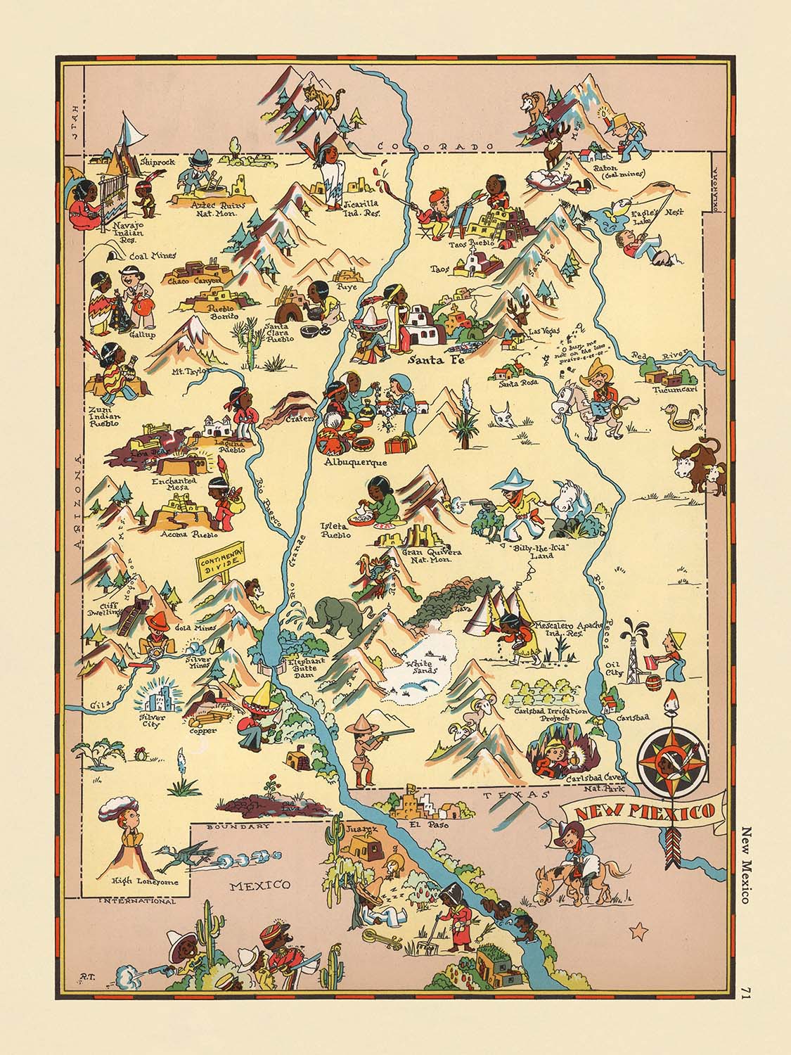
Betreten Sie das lebendige Gewebe des amerikanischen Südwestens mit „New Mexico“, einer faszinierenden bildlichen Karte, die ursprünglich 1935 von der gefeierten Kartografin...
WeiterlesenBetreten Sie das lebendige Gewebe des amerikanischen Südwestens mit „New Mexico“, einer faszinierenden bildlichen Karte, die ursprünglich 1935 von der gefeierten Kartografin Ruth Taylor White erstellt wurde. Diese bezaubernde Karte ist ein herausragendes Beispiel aus Whites skurrilem Atlas, in dem jeder Bundesstaat durch ein Kaleidoskop von Farben, Humor und scharfer Beobachtung zum Leben erweckt wird. Der ursprüngliche Titel „New Mexico“ spiegelt sowohl den geografischen Fokus als auch den kreativen Geist der Epoche wider und lädt die Zuschauer ein, das Land der Verzauberung zu erkunden, wie es zu Beginn des zwanzigsten Jahrhunderts wahrgenommen wurde. Whites Ansatz verwandelt traditionelle Kartografie in eine fesselnde visuelle Erzählung, die Kunstfertigkeit mit geografischer Präzision verbindet.
Ruth Taylor Whites Erbe als Kartenmacherin ist untrennbar mit ihrem einzigartigen Stil verbunden – ihre Karten sind sofort erkennbar für ihre verspielten, cartoonhaften Illustrationen und die akribische Aufmerksamkeit für den regionalen Charakter. Whites Werk geht über bloße Dokumentation hinaus und bietet einen lebendigen Schnappschuss des kulturellen und sozialen Lebens. In „New Mexico“ verwebt sie geschickt die vielfältigen Einflüsse des Bundesstaates, von den Pueblo der amerikanischen Ureinwohner und spanischen Missionen bis zum rauen Leben der Cowboys und Bergleute. Ihre Illustrationen erfassen nicht nur die Landschaft, sondern auch das Wesen ihrer Menschen, Industrien und Traditionen, wodurch jede Karte zu einer wunderbaren Reise durch Zeit und Raum wird.
Das Design dieser Karte ist ein Meisterkurs in der bildlichen Kartografie. Die Landkreisgrenzen sind elegant abgegrenzt, während der ikonische Rio Grande sich durch das Herz des Bundesstaates schlängelt und die Komposition verankert. Die Sangre de Cristo Berge erheben sich majestätisch im Norden, und der Gila National Forest entfaltet sich im Südwesten, jeweils mit künstlerischem Flair dargestellt. Whites skurrile Darstellungen der lokalen Tierwelt, landwirtschaftlicher Szenen und der Wüstenflora – wie Kakteen und Baumwollfelder – fügen Schichten von Textur und Erzählung hinzu und laden den Betrachter ein, über jedes Detail zu verweilen. Die lebendige Farbpalette und die dynamischen Illustrationen der Karte rufen die sonnenverwöhnten Landschaften und das multikulturelle Erbe hervor, die New Mexico definieren.
Ein Höhepunkt dieses bildlichen Meisterwerks ist die Feier von New Mexicos bemerkenswertesten Wahrzeichen und Naturwundern. Die Carlsbad Caverns, ein unterirdisches Wunder, sind prominent dargestellt, ebenso wie die heißen Quellen, die die südliche Landschaft durchziehen. Die Karte zollt dem Pecos River und den Zuni- und Navajo-Regionen Respekt, mit ehrfurchtsvollen Anspielungen auf die indigene Kultur und Kunstfertigkeit. Bergbauaktivitäten, Viehzucht und landwirtschaftliche Bestrebungen werden sowohl mit Genauigkeit als auch mit Charme dargestellt und spiegeln das wirtschaftliche Lebenselixier des Bundesstaates in den 1930er Jahren wider. Durch diese Vignetten wird Whites Karte zu einem lebendigen Dokument der Hoffnungen, Herausforderungen und Errungenschaften der Epoche.
Keine Erkundung von „New Mexico“ wäre vollständig, ohne die Konstellation von Städten und Gemeinden zu erwähnen, die die Karte durchziehen, von Albuquerque und Santa Fe bis zu kleineren Siedlungen wie Socorro und Silver City. Jede ist liebevoll illustriert und spiegelt ihren einzigartigen Charakter und ihre Rolle in der Geschichte des Bundesstaates wider. Der verspielte Stil der Karte verbirgt ihre Informationsfülle und bietet einen Einblick in das soziale und wirtschaftliche Gefüge von New Mexico, wie es vor fast einem Jahrhundert war. Für Sammler und Kenner historischer Kartografie ist Ruth Taylor Whites „New Mexico“ mehr als nur eine Karte – es ist eine Einladung, zu entdecken, sich zu erinnern und ein reichhaltig erzähltes Land zu feiern.
Städte und Gemeinden auf dieser Karte
- Albuquerque
- Las Cruces
- Santa Fe
- Rio Rancho
- Roswell
- Farmington
- Clovis
- Hobbs
- Alamogordo
- Carlsbad
- Gallup
- Deming
- Los Alamos
- Silver City
- Raton
- Tucumcari
- Portales
- Socorro
- Truth or Consequences
- Clayton
Bemerkenswerte Merkmale & Wahrzeichen
- Die Landkreisgrenzen in New Mexico sind deutlich abgegrenzt.
- Der Rio Grande Fluss ist prominent dargestellt und verläuft von Norden nach Süden durch den Bundesstaat.
- Die Carlsbad Caverns sind abgebildet und beschriftet, was ihre Bedeutung als Naturdenkmal hervorhebt.
- Der Gila National Forest ist im südwestlichen Teil des Bundesstaates dargestellt.
- Der Pecos River fließt durch das östliche New Mexico.
- Die Sangre de Cristo Mountains sind im nördlichen Teil des Bundesstaates abgebildet.
- Darstellungen von Pueblo-Indianern und kulturellen Szenen sind vorhanden.
- Bilder von Cowboys und Viehzucht sind zu sehen, die das Erbe der Rinderzucht im Bundesstaat widerspiegeln.
- Darstellungen von Bergbauaktivitäten, wie Bergleute und Bergbaugeräte, sind sichtbar.
- Illustrationen landwirtschaftlicher Tätigkeiten, einschließlich Chili- und Baumwollanbau, sind vorhanden.
- Die Zuni- und Navajo-Regionen sind mit Verweisen auf die Kultur der amerikanischen Ureinwohner dargestellt.
- Die Karte enthält fantasievolle Darstellungen der lokalen Tierwelt, wie Rehe und Schafe.
- Heißwasserquellen sind im südlichen Teil des Bundesstaates dargestellt.
- Die Karte zeigt künstlerische Darstellungen spanischer und mexikanischer kultureller Einflüsse.
- Die Wüstenlandschaft und Kaktuspflanzen sind im südlichen und westlichen Bereich abgebildet.
Historischer und gestalterischer Kontext
- Name der Karte: "New Mexico"
- Erstellungsdatum: 1935
- Kartograf: Ruth Taylor White
- Verleger/Kontext: Teil einer bildlichen Atlasreihe, die von Ruth Taylor White und Frank J. Taylor erstellt wurde, die für ihre fantasievollen und cartoonhaften Darstellungen der US-Bundesstaaten bekannt sind.
- Kartentyp: Landkreis- oder staatliche thematische und bildliche Karte
- Design/Stil: Die Karte bietet lebendige, farbenfrohe Illustrationen mit einem verspielten, cartoonhaften Stil, typisch für bildliche Karten dieser Ära.
- Thematischer Fokus: Die Karte hebt stereotype Szenen und kulturelle Elemente hervor, die mit New Mexico in den 1930er Jahren verbunden sind, einschließlich Darstellungen lokaler Industrien, ethnischer Gruppen und regionaler Aktivitäten.
- Künstlerischer Ansatz: Die Illustrationen sind fantasievoll und übertrieben, um sowohl zu unterhalten als auch zu informieren, und spiegeln die sozialen und kulturellen Erzählungen der Zeit wider.
- Historische Bedeutung: Die Karte gibt Einblick, wie New Mexico in der Populärkultur der 1930er Jahre wahrgenommen und dargestellt wurde, einschließlich gängiger Stereotypen und bemerkenswerter Merkmale des Bundesstaates.
- Bemerkenswerter Kontext über den Kartografen: Ruth Taylor White war bekannt für ihre markanten bildlichen Karten, die Humor, Kunstfertigkeit und geografische Informationen kombinierten und zur Popularisierung der bildlichen Kartografie im frühen 20. Jahrhundert beitrugen.
Bitte überprüfen Sie die Bilder, um sicherzustellen, dass eine bestimmte Stadt oder ein Ort auf dieser Karte dargestellt ist. Sie können uns auch kontaktieren und bitten, die Karte für Sie zu überprüfen.
Diese Karte sieht in jeder Größe großartig aus, aber ich empfehle immer, eine größere Größe zu wählen, wenn Sie Platz haben. So können Sie alle Details leicht erkennen.
Diese Karte sieht in Größen bis zu 50 Zoll (125 cm) erstaunlich aus. Wenn Sie eine größere Karte suchen, kontaktieren Sie uns bitte hier.
Das Modell auf den Abbildungsbildern hält die 18x24 Zoll (45x60 cm) Version dieser Karte.
Das fünfte Abbildungsbild zeigt ein Beispiel für meinen Personalisierungsservice für Karten.
Wenn Sie nach etwas anderem suchen, schauen Sie sich meine Sammlung der besten alten Karten an, um zu sehen, ob etwas anderes Ihr Interesse weckt.
Bitte kontaktieren Sie mich, um zu überprüfen, ob ein bestimmter Ort, Wahrzeichen oder Merkmal auf dieser Karte angezeigt wird.
Dies wäre ein wunderbares Geschenk zum Geburtstag, Weihnachten, Vatertag, Abschied von der Arbeit, Jubiläum oder Einweihung für jemanden aus den Gebieten, die von dieser Karte abgedeckt werden.
Diese Karte ist als Giclée-Druck auf säurefreiem, archivierbarem mattem Papier erhältlich, oder Sie können sie gerahmt kaufen. Der Rahmen ist ein schöner, einfacher schwarzer Rahmen, der zu den meisten Ästhetiken passt. Bitte setzen Sie sich mit mir in Verbindung, wenn Sie eine andere Rahmenfarbe oder -material wünschen. Meine Rahmen sind mit superklarem museumsgüte Acryl (Plexiglas/Acrylt) verglast, das deutlich weniger reflektierend als Glas ist, sicherer ist und immer in einwandfreiem Zustand ankommt.
This map is also available as a float framed canvas, sometimes known as a shadow gap framed canvas or canvas floater. The map is printed on artist's cotton canvas and then stretched over a handmade box frame. We then "float" the canvas inside a wooden frame, which is available in a range of colours (black, dark brown, oak, antique gold and white). This is a wonderful way to present a map without glazing in front. See some examples of float framed canvas maps and explore the differences between my different finishes.
For something truly unique, this map is also available in "Unique 3D", our trademarked process that dramatically transforms the map so that it has a wonderful sense of depth. We combine the original map with detailed topography and elevation data, so that mountains and the terrain really "pop". For more info and examples of 3D maps, check my Unique 3D page.
Betreten Sie das lebendige Gewebe des amerikanischen Südwestens mit „New Mexico“, einer faszinierenden bildlichen Karte, die ursprünglich 1935 von der gefeierten Kartografin Ruth Taylor White erstellt wurde. Diese bezaubernde Karte ist ein herausragendes Beispiel aus Whites skurrilem Atlas, in dem jeder Bundesstaat durch ein Kaleidoskop von Farben, Humor und scharfer Beobachtung zum Leben erweckt wird. Der ursprüngliche Titel „New Mexico“ spiegelt sowohl den geografischen Fokus als auch den kreativen Geist der Epoche wider und lädt die Zuschauer ein, das Land der Verzauberung zu erkunden, wie es zu Beginn des zwanzigsten Jahrhunderts wahrgenommen wurde. Whites Ansatz verwandelt traditionelle Kartografie in eine fesselnde visuelle Erzählung, die Kunstfertigkeit mit geografischer Präzision verbindet.
Ruth Taylor Whites Erbe als Kartenmacherin ist untrennbar mit ihrem einzigartigen Stil verbunden – ihre Karten sind sofort erkennbar für ihre verspielten, cartoonhaften Illustrationen und die akribische Aufmerksamkeit für den regionalen Charakter. Whites Werk geht über bloße Dokumentation hinaus und bietet einen lebendigen Schnappschuss des kulturellen und sozialen Lebens. In „New Mexico“ verwebt sie geschickt die vielfältigen Einflüsse des Bundesstaates, von den Pueblo der amerikanischen Ureinwohner und spanischen Missionen bis zum rauen Leben der Cowboys und Bergleute. Ihre Illustrationen erfassen nicht nur die Landschaft, sondern auch das Wesen ihrer Menschen, Industrien und Traditionen, wodurch jede Karte zu einer wunderbaren Reise durch Zeit und Raum wird.
Das Design dieser Karte ist ein Meisterkurs in der bildlichen Kartografie. Die Landkreisgrenzen sind elegant abgegrenzt, während der ikonische Rio Grande sich durch das Herz des Bundesstaates schlängelt und die Komposition verankert. Die Sangre de Cristo Berge erheben sich majestätisch im Norden, und der Gila National Forest entfaltet sich im Südwesten, jeweils mit künstlerischem Flair dargestellt. Whites skurrile Darstellungen der lokalen Tierwelt, landwirtschaftlicher Szenen und der Wüstenflora – wie Kakteen und Baumwollfelder – fügen Schichten von Textur und Erzählung hinzu und laden den Betrachter ein, über jedes Detail zu verweilen. Die lebendige Farbpalette und die dynamischen Illustrationen der Karte rufen die sonnenverwöhnten Landschaften und das multikulturelle Erbe hervor, die New Mexico definieren.
Ein Höhepunkt dieses bildlichen Meisterwerks ist die Feier von New Mexicos bemerkenswertesten Wahrzeichen und Naturwundern. Die Carlsbad Caverns, ein unterirdisches Wunder, sind prominent dargestellt, ebenso wie die heißen Quellen, die die südliche Landschaft durchziehen. Die Karte zollt dem Pecos River und den Zuni- und Navajo-Regionen Respekt, mit ehrfurchtsvollen Anspielungen auf die indigene Kultur und Kunstfertigkeit. Bergbauaktivitäten, Viehzucht und landwirtschaftliche Bestrebungen werden sowohl mit Genauigkeit als auch mit Charme dargestellt und spiegeln das wirtschaftliche Lebenselixier des Bundesstaates in den 1930er Jahren wider. Durch diese Vignetten wird Whites Karte zu einem lebendigen Dokument der Hoffnungen, Herausforderungen und Errungenschaften der Epoche.
Keine Erkundung von „New Mexico“ wäre vollständig, ohne die Konstellation von Städten und Gemeinden zu erwähnen, die die Karte durchziehen, von Albuquerque und Santa Fe bis zu kleineren Siedlungen wie Socorro und Silver City. Jede ist liebevoll illustriert und spiegelt ihren einzigartigen Charakter und ihre Rolle in der Geschichte des Bundesstaates wider. Der verspielte Stil der Karte verbirgt ihre Informationsfülle und bietet einen Einblick in das soziale und wirtschaftliche Gefüge von New Mexico, wie es vor fast einem Jahrhundert war. Für Sammler und Kenner historischer Kartografie ist Ruth Taylor Whites „New Mexico“ mehr als nur eine Karte – es ist eine Einladung, zu entdecken, sich zu erinnern und ein reichhaltig erzähltes Land zu feiern.
Städte und Gemeinden auf dieser Karte
- Albuquerque
- Las Cruces
- Santa Fe
- Rio Rancho
- Roswell
- Farmington
- Clovis
- Hobbs
- Alamogordo
- Carlsbad
- Gallup
- Deming
- Los Alamos
- Silver City
- Raton
- Tucumcari
- Portales
- Socorro
- Truth or Consequences
- Clayton
Bemerkenswerte Merkmale & Wahrzeichen
- Die Landkreisgrenzen in New Mexico sind deutlich abgegrenzt.
- Der Rio Grande Fluss ist prominent dargestellt und verläuft von Norden nach Süden durch den Bundesstaat.
- Die Carlsbad Caverns sind abgebildet und beschriftet, was ihre Bedeutung als Naturdenkmal hervorhebt.
- Der Gila National Forest ist im südwestlichen Teil des Bundesstaates dargestellt.
- Der Pecos River fließt durch das östliche New Mexico.
- Die Sangre de Cristo Mountains sind im nördlichen Teil des Bundesstaates abgebildet.
- Darstellungen von Pueblo-Indianern und kulturellen Szenen sind vorhanden.
- Bilder von Cowboys und Viehzucht sind zu sehen, die das Erbe der Rinderzucht im Bundesstaat widerspiegeln.
- Darstellungen von Bergbauaktivitäten, wie Bergleute und Bergbaugeräte, sind sichtbar.
- Illustrationen landwirtschaftlicher Tätigkeiten, einschließlich Chili- und Baumwollanbau, sind vorhanden.
- Die Zuni- und Navajo-Regionen sind mit Verweisen auf die Kultur der amerikanischen Ureinwohner dargestellt.
- Die Karte enthält fantasievolle Darstellungen der lokalen Tierwelt, wie Rehe und Schafe.
- Heißwasserquellen sind im südlichen Teil des Bundesstaates dargestellt.
- Die Karte zeigt künstlerische Darstellungen spanischer und mexikanischer kultureller Einflüsse.
- Die Wüstenlandschaft und Kaktuspflanzen sind im südlichen und westlichen Bereich abgebildet.
Historischer und gestalterischer Kontext
- Name der Karte: "New Mexico"
- Erstellungsdatum: 1935
- Kartograf: Ruth Taylor White
- Verleger/Kontext: Teil einer bildlichen Atlasreihe, die von Ruth Taylor White und Frank J. Taylor erstellt wurde, die für ihre fantasievollen und cartoonhaften Darstellungen der US-Bundesstaaten bekannt sind.
- Kartentyp: Landkreis- oder staatliche thematische und bildliche Karte
- Design/Stil: Die Karte bietet lebendige, farbenfrohe Illustrationen mit einem verspielten, cartoonhaften Stil, typisch für bildliche Karten dieser Ära.
- Thematischer Fokus: Die Karte hebt stereotype Szenen und kulturelle Elemente hervor, die mit New Mexico in den 1930er Jahren verbunden sind, einschließlich Darstellungen lokaler Industrien, ethnischer Gruppen und regionaler Aktivitäten.
- Künstlerischer Ansatz: Die Illustrationen sind fantasievoll und übertrieben, um sowohl zu unterhalten als auch zu informieren, und spiegeln die sozialen und kulturellen Erzählungen der Zeit wider.
- Historische Bedeutung: Die Karte gibt Einblick, wie New Mexico in der Populärkultur der 1930er Jahre wahrgenommen und dargestellt wurde, einschließlich gängiger Stereotypen und bemerkenswerter Merkmale des Bundesstaates.
- Bemerkenswerter Kontext über den Kartografen: Ruth Taylor White war bekannt für ihre markanten bildlichen Karten, die Humor, Kunstfertigkeit und geografische Informationen kombinierten und zur Popularisierung der bildlichen Kartografie im frühen 20. Jahrhundert beitrugen.
Bitte überprüfen Sie die Bilder, um sicherzustellen, dass eine bestimmte Stadt oder ein Ort auf dieser Karte dargestellt ist. Sie können uns auch kontaktieren und bitten, die Karte für Sie zu überprüfen.
Diese Karte sieht in jeder Größe großartig aus, aber ich empfehle immer, eine größere Größe zu wählen, wenn Sie Platz haben. So können Sie alle Details leicht erkennen.
Diese Karte sieht in Größen bis zu 50 Zoll (125 cm) erstaunlich aus. Wenn Sie eine größere Karte suchen, kontaktieren Sie uns bitte hier.
Das Modell auf den Abbildungsbildern hält die 18x24 Zoll (45x60 cm) Version dieser Karte.
Das fünfte Abbildungsbild zeigt ein Beispiel für meinen Personalisierungsservice für Karten.
Wenn Sie nach etwas anderem suchen, schauen Sie sich meine Sammlung der besten alten Karten an, um zu sehen, ob etwas anderes Ihr Interesse weckt.
Bitte kontaktieren Sie mich, um zu überprüfen, ob ein bestimmter Ort, Wahrzeichen oder Merkmal auf dieser Karte angezeigt wird.
Dies wäre ein wunderbares Geschenk zum Geburtstag, Weihnachten, Vatertag, Abschied von der Arbeit, Jubiläum oder Einweihung für jemanden aus den Gebieten, die von dieser Karte abgedeckt werden.
Diese Karte ist als Giclée-Druck auf säurefreiem, archivierbarem mattem Papier erhältlich, oder Sie können sie gerahmt kaufen. Der Rahmen ist ein schöner, einfacher schwarzer Rahmen, der zu den meisten Ästhetiken passt. Bitte setzen Sie sich mit mir in Verbindung, wenn Sie eine andere Rahmenfarbe oder -material wünschen. Meine Rahmen sind mit superklarem museumsgüte Acryl (Plexiglas/Acrylt) verglast, das deutlich weniger reflektierend als Glas ist, sicherer ist und immer in einwandfreiem Zustand ankommt.
This map is also available as a float framed canvas, sometimes known as a shadow gap framed canvas or canvas floater. The map is printed on artist's cotton canvas and then stretched over a handmade box frame. We then "float" the canvas inside a wooden frame, which is available in a range of colours (black, dark brown, oak, antique gold and white). This is a wonderful way to present a map without glazing in front. See some examples of float framed canvas maps and explore the differences between my different finishes.
For something truly unique, this map is also available in "Unique 3D", our trademarked process that dramatically transforms the map so that it has a wonderful sense of depth. We combine the original map with detailed topography and elevation data, so that mountains and the terrain really "pop". For more info and examples of 3D maps, check my Unique 3D page.
Many of our maps and art prints are chosen as thoughtful gifts for homes, offices, studies and meaningful places.
Choose a framed option for the easiest ready-to-hang gift, or choose an unframed print if the recipient may prefer to select their own frame.
We make orders locally in 23 countries around the world, so gifts can often be produced close to the recipient. This helps them arrive faster, travel more safely, and avoid customs or import duty surprises.
- We can deliver directly to the recipient
- Framed pieces arrive ready to hang
- Unframed prints are carefully packed in a strong protective tube
- Almost every order is made locally, for faster, safer gifting
- 90-day returns give the recipient time to decide
If you are not sure what to choose, please contact us. We can help you pick the right map, size, finish or delivery option.
Für die meisten Bestellungen beträgt die Lieferzeit etwa 3 Werktage. Personalisierte und maßgeschneiderte Produkte benötigen länger, da ich die Personalisierung durchführen und sie Ihnen zur Genehmigung zusenden muss, was normalerweise 1 oder 2 Tage dauert.
Bitte beachten Sie, dass sehr große gerahmte Bestellungen in der Regel länger für die Herstellung und Lieferung benötigen.
Wenn Sie möchten, dass Ihre Bestellung bis zu einem bestimmten Datum ankommt, bitte kontaktieren Sie mich, bevor Sie bestellen, damit wir den besten Weg finden können, um sicherzustellen, dass Sie Ihre Bestellung rechtzeitig erhalten.
Ich drucke und rahme Karten und Kunstwerke in 23 Ländern weltweit. Das bedeutet, dass Ihre Bestellung lokal gefertigt wird, was die Lieferzeit verkürzt und sicherstellt, dass sie während der Lieferung nicht beschädigt wird. Sie zahlen nie Zoll oder Einfuhrgebühren, und wir stoßen weniger CO2 in die Luft aus.
Alle meine Karten und Kunstdrucke sind gut verpackt und werden in einem robusten Rohr versendet, wenn sie ungerahmt sind, oder von Schaum umgeben, wenn sie gerahmt sind.
Ich versuche, alle Bestellungen innerhalb von 1 oder 2 Tagen nach Erhalt Ihrer Bestellung zu versenden, obwohl einige Produkte (wie Gesichtsmasken, Tassen und Tragetaschen) länger zur Herstellung benötigen können.
Wenn Sie Express-Lieferung an der Kasse auswählen, priorisieren wir Ihre Bestellung und versenden sie per 1-Tages-Kurier (Fedex, DHL, UPS, Parcelforce).
Nächster Tag Lieferung ist auch in einigen Ländern verfügbar (USA, UK, Singapur, VAE), aber bitte versuchen Sie, früh am Tag zu bestellen, damit wir es rechtzeitig versenden können.
Lesen Sie meinen vollständigen Leitfaden zur Lieferung und lokalen Produktion
Mein Standardrahmen ist ein Galerie-Stil-Rahmen aus schwarzem Eschenholz. Er ist einfach und sieht ziemlich modern aus. Mein Standardrahmen ist etwa 20 mm (0,8 Zoll) breit.
Ich verwende super-klares Acryl (Plexiglas/Acrylt) für das Glas des Rahmens. Es ist leichter und sicherer als Glas – und es sieht besser aus, da die Reflexion geringer ist.
Sechs Standardrahmenfarben sind kostenlos erhältlich (schwarz, dunkelbraun, dunkelgrau, Eiche, weiß und antikgold).
Die meisten Karten, Kunstwerke und Illustrationen sind auch als gerahmte Leinwand erhältlich. Wir verwenden matte (nicht glänzende) Baumwollleinwand, spannen sie über einen nachhaltig beschafften Buchenrahmen und 'schweben' dann das Stück innerhalb eines Holzrahmens. Das Endergebnis ist ziemlich schön, und es gibt keine Verglasung, die im Weg ist.
Alle Rahmen werden "bereit zum Aufhängen" geliefert, entweder mit einer Schnur oder Halterungen auf der Rückseite. Sehr große Rahmen haben schwere Aufhängeplatten und/oder eine Montageschiene. Wenn Sie Fragen haben, können Sie bitte Kontakt aufnehmen.
Sehen Sie sich einige Beispiele meiner gerahmten Karten und gerahmten Leinwandkarten an.
Alternativ kann ich auch alte Karten und Kunstwerke auf Leinwand, Schaumstoffplatten, Baumwollrag und andere Materialien liefern.
Wenn Sie Ihre Karte oder Ihr Kunstwerk selbst rahmen möchten, lesen Sie bitte zuerst meinen Größenleitfaden.
Meine Karten sind äußerst hochwertige Reproduktionen von Originalkarten.
Ich beziehe originale, seltene Karten aus Bibliotheken, Auktionshäusern und Privatsammlungen auf der ganzen Welt, restauriere sie in meiner Londoner Werkstatt und erstelle dann mit speziellen Giclée-Tinten und -Druckern wunderschöne Karten, die sogar noch besser aussehen als das Original.
Meine Karten werden auf säurefreiem, mattem Archivpapier (nicht glänzend) gedruckt, das sich sehr hochwertig anfühlt und fast wie Karton aussieht. Technisch gesehen beträgt das Papiergewicht/die Papierdicke 10mil/200g/m². Es eignet sich perfekt zum Einrahmen.
Ich drucke mit UV-lichtbeständigen Ultrachrome-Giclée-Pigmenttinten von Epson – einige der besten Tinten, die Sie finden können.
Ich kann auch machen Karten auf Leinwand, Baumwolllappen und andere exotische Materialien.
Erfahren Sie mehr über The Unique Maps Co.
Kartenpersonalisierung
Wenn Sie nach dem perfekten Geschenk zum Jahrestag oder zur Einweihung suchen, kann ich Ihre Karte personalisieren, um sie wirklich einzigartig zu machen. Ich kann beispielsweise eine kurze Nachricht hinzufügen, einen wichtigen Ort hervorheben oder das Wappen Ihrer Familie hinzufügen.
Die Möglichkeiten sind nahezu unbegrenzt. Bitte sehen Sie sich meine Kartenpersonalisierungsseite für einige wunderbare Beispiele dessen, was möglich ist.
Um eine personalisierte Karte zu bestellen, wählen Sie „Personalisieren Sie Ihre Karte“, bevor Sie sie in den Warenkorb legen.
In Kontakt kommen wenn Sie nach komplexeren Anpassungen und Personalisierungen suchen.
Kartenalterung
Im Laufe der Jahre wurde ich von Kunden hunderte Male gefragt, ob sie eine Karte kaufen könnten, die noch älter.
Nun, jetzt können Sie das, indem Sie „Alter“ auswählen, bevor Sie eine Karte in Ihren Warenkorb legen.
Alle Produktfotos, die Sie auf dieser Seite sehen, zeigen die Karte in ihrer Originalform. So sieht die Karte heute aus.
Wenn Sie „Gealtert“ auswählen, werde ich Ihre Karte von Hand altern lassen. Dazu verwende ich ein spezielles und einzigartiges Verfahren, das ich durch jahrelanges Studium alter Karten und Gespräche mit Forschern zum Verständnis der Chemie alternder Papiere entwickelt habe, und natürlich ... viel Übung!
Wenn Sie sich nicht sicher sind, bleiben Sie bei der Originalfarbe der Karte. Wenn Sie etwas Dunkleres und älter Wenn Sie auf der Suche sind, entscheiden Sie sich für „Aged“.
Sehen Sie einige erstaunliche Beispiele für gealterte Karten.
Wenn Sie aus irgendeinem Grund mit Ihrer Bestellung nicht zufrieden sind, kontaktieren Sie mich für eine unkomplizierte Rückerstattung. Bitte sehen Sie sich unsere Rückgabe- und Rückerstattungsrichtlinien für weitere Informationen an.
Ich bin sehr zuversichtlich, dass Ihnen Ihre restaurierte Karte oder Kunstdruck gefallen wird. Ich mache das seit 1984. Ich bin ein 5-Sterne Etsy-Verkäufer. Ich habe Zehntausende von Karten und Kunstdrucken verkauft und habe über 5.000 echte 5-Sterne-Bewertungen.
Ich verwende einen einzigartigen Prozess, um Karten und Kunstwerke zu restaurieren, der extrem zeitaufwendig und arbeitsintensiv ist. Die Suche nach den Originalkarten und Illustrationen kann Monate dauern. Ich benutze modernste und unglaublich teure Technologie, um sie zu scannen und wiederherzustellen. Daher garantiere ich, dass meine Karten und Kunstdrucke eine Klasse für sich sind - deshalb kann ich eine unkomplizierte Rückerstattung anbieten.
Fast alle meine Karten und Kunstdrucke sehen in großen Größen (200 cm, 6,5 Fuß+) erstaunlich aus und ich kann sie Ihnen auch gerahmt und über einen speziellen Übergrößen-Kurier liefern. Kontaktieren Sie mich, um Ihre speziellen Bedürfnisse zu besprechen.
Or try searching for something!


