


Bildkarte von Florida von Ruth Taylor White, 1935: Everglades, Miami, Orlando, Keys, Zitrushaine
Das Sammlerangebot
Wählen Sie zwei berechtigte Werke und erhalten Sie auf beide 20 % Rabatt. Wählen Sie drei, und das günstigste ist kostenlos – eine maximale Ersparnis von 33 %.
Kombinieren Sie berechtigte Standardkarten und Kunstdrucke nach Belieben. Kein Code erforderlich; das Angebot wird an der Kasse automatisch angewendet.
Standardmäßige Konfigurationen nach Maßanfertigung sind inbegriffen. Maßgeschneiderte Größen, personalisierte Entwürfe und Auftragsarbeiten sind ausgeschlossen.
Benötigen Sie die Lieferung an unterschiedliche Adressen? Kontaktieren Sie uns vor der Bestellung.Das Sammlerangebot
Wählen Sie zwei berechtigte Werke und erhalten Sie auf beide 20 % Rabatt. Wählen Sie drei, und das günstigste ist kostenlos – eine maximale Ersparnis von 33 %.
Kombinieren Sie berechtigte Standardkarten und Kunstdrucke nach Belieben. Kein Code erforderlich; das Angebot wird an der Kasse automatisch angewendet.
Standardmäßige Konfigurationen nach Maßanfertigung sind inbegriffen. Maßgeschneiderte Größen, personalisierte Entwürfe und Auftragsarbeiten sind ausgeschlossen.
Benötigen Sie die Lieferung an unterschiedliche Adressen? Kontaktieren Sie uns vor der Bestellung. In London gestaltet Hergestellt in Australia
In London gestaltet • Hergestellt in Australia
In London gestaltet Hergestellt in Australia
In London gestaltet • Hergestellt in Australia

Aus der Originalkarte von 1935 restauriert und in Museumsqualität gedruckt. Die Geschichte hinter dieser Karte lesen
Choose your size
Choose your finish


(Mehr Infos)
Geschenkmitteilung & individuelle Ausführung

Wenn Sie eine Geschenkmitteilung oder eine Ausführung (Puzzle, Aluminiumplatte usw.) hinzufügen möchten, die hier nicht verfügbar ist, geben Sie dies bitte in der "Bestellnotiz" beim Checkout an.
Jede Bestellung wird individuell angefertigt. Wenn Sie die Größe leicht anpassen oder auf einem ungewöhnlichen Material drucken lassen möchten, lassen Sie es uns einfach wissen. Wir haben im Laufe der Jahre Tausende von individuellen Bestellungen bearbeitet, daher gibt es (fast) nichts, was wir nicht bewältigen können.
Sie können uns auch kontaktieren, bevor Sie bestellen, wenn Sie möchten!

- Lokal gefertigt. Sicher geliefert
- Keine Zölle oder versteckten Gebühren
- Hilfe nötig? Rufen Sie uns an oder WhatsApp schreiben
Own a piece of history
8,000+ five-star reviews


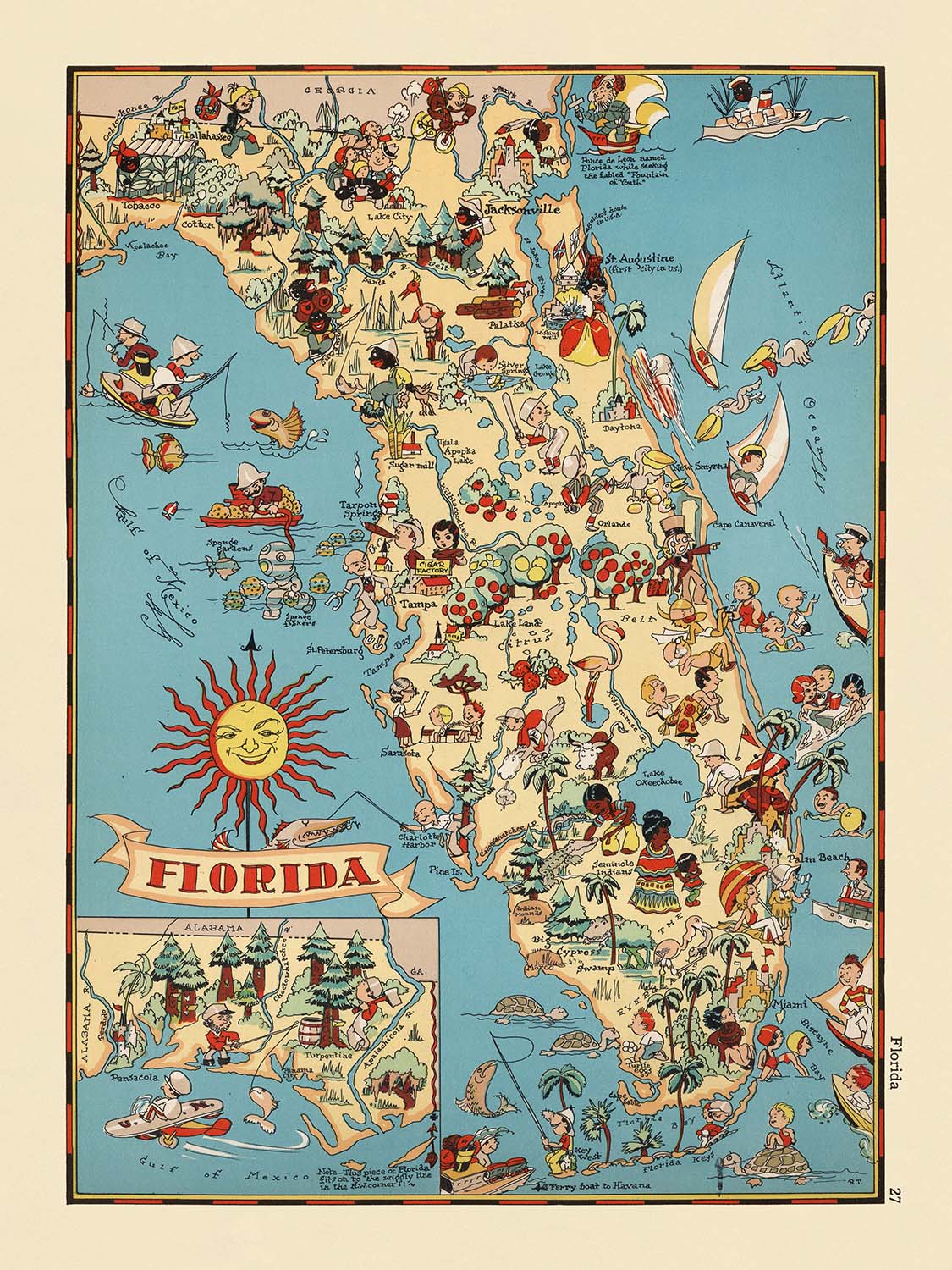
Betreten Sie die lebendige Welt von Florida in den 1930er Jahren mit der fesselnden bildlichen Karte, die einfach "Florida" heißt und 1935...
WeiterlesenBetreten Sie die lebendige Welt von Florida in den 1930er Jahren mit der fesselnden bildlichen Karte, die einfach "Florida" heißt und 1935 von der talentierten Ruth Taylor White erstellt wurde. Dieses bemerkenswerte Werk ist mehr als eine geografische Darstellung; es ist eine Feier des einzigartigen Charakters des Sunshine State, eingefangen durch Whites verspielte und ansprechende künstlerische Linse. Der ursprüngliche Titel der Karte spiegelt ihr breites Ziel wider – die Essenz Floridas in einem entscheidenden Moment seiner Geschichte einzufangen, gerade als der Staat sich als nationales Ziel für Freizeit, Landwirtschaft und Abenteuer entwickelte.
Ruth Taylor White war bekannt für ihren spielerischen, aber informativen Ansatz zur Kartografie, und diese Karte ist ein Zeugnis ihres kreativen Genies. Ihr unverwechselbarer Stil verbindet lebendige Farbpaletten mit cartoonhaften Illustrationen und verwandelt die Landschaft in ein lebendiges Tableau von Floridas Menschen, Industrien und natürlichen Wundern. Whites Werk war Teil einer breiteren Bewegung in den 1930er Jahren, um Karten sowohl lehrreich als auch unterhaltsam zu gestalten, und lädt Zuschauer jeden Alters ein, die Vielfalt der amerikanischen Landschaft zu erkunden und zu schätzen.
Die Karte ist lebendig mit fantasievollen Darstellungen von Floridas ikonischsten Merkmalen. Von den geheimnisvollen Everglades, die von Alligatoren wimmeln, und den sonnenverwöhnten Florida Keys bis hin zu üppigen Orangenplantagen und weitläufigen Zuckerrohrfeldern wird jede Ecke des Staates mit liebevollen Details dargestellt. Die Anwesenheit von Palmen, Flamingos und Szenen des Fischens und Bootfahrens evoziert den anhaltenden Reiz des Staates als Paradies für sowohl Einwohner als auch Besucher. Bemerkenswert ist, dass White Vignetten von Seminolen und Schwammtauchern einfügt, was eine Hommage an Floridas indigene Erbschaft und die Industrien darstellt, die seine Küstengemeinden prägten.
Städte und Gemeinden sind sorgfältig beschriftet, jede eingebettet in Illustrationen, die auf ihre historische und kulturelle Bedeutung hinweisen. Jacksonville, Miami, Tampa und Orlando – jetzt pulsierende städtische Zentren – stehen neben kleineren, geschichtsträchtigen Orten wie Key West, St. Augustine und Tarpon Springs. Die verspielten Szenen der Karte mit Golfplätzen, Rinderfarmen und sogar Alligatorenringen spiegeln sowohl die Realität als auch die Mythologie des Lebens in Florida in den 1930er Jahren wider und machen sie zu einem reichen Teppich der facettenreichen Identität des Staates.
Historisch gesehen ist diese Karte ein Fenster in eine vergangene Ära und fängt den Optimismus und die Vorstellungskraft der Zeit ein. Sie wurde während der Großen Depression erstellt, einer Zeit, in der die Amerikaner Karten und Reisen als Quellen der Hoffnung und des Eskapismus betrachteten. Whites Werk chartiert nicht nur Grenzen und Städte – es verkörpert den Geist Floridas und lädt Sammler und Enthusiasten ein, in eine Zeit zurückzukehren, als sich der Staat schnell verwandelte, aber immer noch tief verwurzelt war in seiner natürlichen Schönheit und kulturellen Traditionen. Diese Karte ist nicht nur ein Stück Geschichte; sie ist ein Kunstwerk, das weiterhin Staunen und Bewunderung inspiriert.
Städte und Gemeinden auf dieser Karte
- Jacksonville
- Miami
- Tampa
- Orlando
- St. Petersburg
- Hialeah
- Fort Lauderdale
- Tallahassee
- Cape Coral
- Port St. Lucie
- Pembroke Pines
- Hollywood
- Gainesville
- Coral Gables
- Key West
- Daytona Beach
- Pensacola
- Lakeland
- Sarasota
- Ocala
- Fort Myers
- St. Augustine
- Sanford
- Winter Haven
- Tarpon Springs
Bemerkenswerte Merkmale & Wahrzeichen
- Die Everglades sind illustriert und beschriftet, was Floridas einzigartiges Feuchtgebiet-Ökosystem hervorhebt.
- Die Florida Keys sind dargestellt, wobei ihre geografische und kulturelle Bedeutung betont wird.
- Eine Illustration von Orangen und Orangenplantagen, die Floridas Zitrusindustrie repräsentiert.
- Palmen und Strände, die Floridas tropisches Klima und seine Anziehungskraft als Touristenziel symbolisieren.
- Krokodile werden gezeigt, die auf die berühmte Tierwelt des Bundesstaates verweisen.
- Segelboote und Wassersport, die auf Freizeitaktivitäten in Floridas Küstengebieten hinweisen.
- Illustrationen von Seminolen, die die Präsenz und das kulturelle Erbe der Ureinwohner Floridas widerspiegeln.
- Flamingos, die die ausgeprägte Vogelwelt des Bundesstaates repräsentieren.
- Rinder und Ranch-Szenen, die landwirtschaftliche Aktivitäten hervorheben.
- Eine Darstellung eines Golfplatzes, die auf Floridas Beliebtheit als Golfziel verweist.
- Ein Dampfschiff auf einem Fluss, das historische Transportmittel anzeigt.
- Angelszenen, die Floridas Ruf für Sportfischen zeigen.
- Eine Darstellung eines Schwammtauchers, die auf die Schwammindustrie, insbesondere rund um Tarpon Springs, verweist.
- Zuckerrohrfelder, die die landwirtschaftliche Produktion in Süd-Florida repräsentieren.
- Eine Szene mit einem Mann, der mit einem Alligator ringt, ein Hinweis auf beliebte Touristenattraktionen und Unterhaltung der damaligen Zeit.
Historischer und gestalterischer Kontext
- Name der Karte: Florida (ursprünglicher Titel, wie auf der Karte gezeigt).
- Kartenmacher: Ruth Taylor White, eine bemerkenswerte Illustratorin, die in den 1930er Jahren für ihre fantasievollen und farbenfrohen bildlichen Karten bekannt war.
- Erstellungsdatum: 1935.
- Verlag/Kontext: Teil einer Reihe von bildlichen oder cartoonhaften Atlanten der Vereinigten Staaten, die sowohl zur Unterhaltung als auch zur Information gedacht sind.
- Kartentyp: Thematische und bildliche Karte des Landkreises oder Bundesstaates.
- Künstlerischer Stil: Die Karte verwendet lebendige, verspielte Illustrationen und cartoonartige Darstellungen, um die Kultur, Wirtschaft und den Lebensstil Floridas in den 1930er Jahren darzustellen.
- Themen/Themenbereiche: Stereotypische Szenen und Aktivitäten, einzigartige kulturelle Elemente und bemerkenswerte Wahrzeichen Floridas, wie sie in den 1930er Jahren wahrgenommen wurden.
- Geografische Abdeckung: Der gesamte Bundesstaat Florida, mit umreißenden und beschrifteten Landkreisen.
- Historische Bedeutung: Reflektiert sowohl die Populärkultur als auch die wirtschaftlichen Aktivitäten Floridas während der Zeit der Großen Depression und bietet Einblicke, wie der Bundesstaat damals wahrgenommen und beworben wurde.
- Sammlerwert: Hoch geschätzt von Sammlern und Enthusiasten historischer Karten und amerikanischer Kunst des frühen 20. Jahrhunderts.
- Bildungszweck: Soll sowohl unterhalten als auch die Zuschauer über Floridas Geografie und kulturelle Identität auf visuell ansprechende Weise informieren.
Bitte überprüfen Sie die Bilder, um sicherzustellen, dass eine bestimmte Stadt oder ein Ort auf dieser Karte angezeigt wird. Sie können uns auch kontaktieren und bitten, die Karte für Sie zu überprüfen.
Diese Karte sieht in jeder Größe großartig aus, aber ich empfehle immer, eine größere Größe zu wählen, wenn Sie Platz haben. So können Sie alle Details leicht erkennen.
Diese Karte sieht bis zu 50 Zoll (125 cm) großartig aus. Wenn Sie nach einer größeren Karte suchen, bitte kontaktieren Sie uns.
Das Modell in den Abbildungsbildern hält die 18x24 Zoll (45x60 cm) Version dieser Karte.
Das fünfte Abbildungsbild zeigt ein Beispiel für meinen Personalisierungsservice für Karten.
Wenn Sie nach etwas anderem suchen, schauen Sie sich meine Sammlung der besten alten Karten an, um zu sehen, ob Ihnen etwas anderes ins Auge fällt.
Bitte kontaktieren Sie mich, um zu überprüfen, ob ein bestimmter Ort, ein Wahrzeichen oder ein Merkmal auf dieser Karte angezeigt wird.
Dies wäre ein wunderbares Geburtstags-, Weihnachts-, Vatertags-, Abschieds-, Jubiläums- oder Einweihungsgeschenk für jemanden aus den in dieser Karte abgedeckten Gebieten.
Diese Karte ist als Giclée-Druck auf säurefreiem, archivfestem mattem Papier erhältlich, oder Sie können sie gerahmt kaufen. Der Rahmen ist ein schöner, einfacher schwarzer Rahmen, der zu den meisten Ästhetiken passt. Bitte kontaktieren Sie mich, wenn Sie eine andere Rahmenfarbe oder -material wünschen. Meine Rahmen sind mit superklarem, museumsgrauem Acryl (Plexiglas/Acrylt) verglast, das erheblich weniger reflektierend ist als Glas, sicherer ist und immer in einwandfreiem Zustand ankommt.
This map is also available as a float framed canvas, sometimes known as a shadow gap framed canvas or canvas floater. The map is printed on artist's cotton canvas and then stretched over a handmade box frame. We then "float" the canvas inside a wooden frame, which is available in a range of colours (black, dark brown, oak, antique gold and white). This is a wonderful way to present a map without glazing in front. See some examples of float framed canvas maps and explore the differences between my different finishes.
For something truly unique, this map is also available in "Unique 3D", our trademarked process that dramatically transforms the map so that it has a wonderful sense of depth. We combine the original map with detailed topography and elevation data, so that mountains and the terrain really "pop". For more info and examples of 3D maps, check my Unique 3D page.
Betreten Sie die lebendige Welt von Florida in den 1930er Jahren mit der fesselnden bildlichen Karte, die einfach "Florida" heißt und 1935 von der talentierten Ruth Taylor White erstellt wurde. Dieses bemerkenswerte Werk ist mehr als eine geografische Darstellung; es ist eine Feier des einzigartigen Charakters des Sunshine State, eingefangen durch Whites verspielte und ansprechende künstlerische Linse. Der ursprüngliche Titel der Karte spiegelt ihr breites Ziel wider – die Essenz Floridas in einem entscheidenden Moment seiner Geschichte einzufangen, gerade als der Staat sich als nationales Ziel für Freizeit, Landwirtschaft und Abenteuer entwickelte.
Ruth Taylor White war bekannt für ihren spielerischen, aber informativen Ansatz zur Kartografie, und diese Karte ist ein Zeugnis ihres kreativen Genies. Ihr unverwechselbarer Stil verbindet lebendige Farbpaletten mit cartoonhaften Illustrationen und verwandelt die Landschaft in ein lebendiges Tableau von Floridas Menschen, Industrien und natürlichen Wundern. Whites Werk war Teil einer breiteren Bewegung in den 1930er Jahren, um Karten sowohl lehrreich als auch unterhaltsam zu gestalten, und lädt Zuschauer jeden Alters ein, die Vielfalt der amerikanischen Landschaft zu erkunden und zu schätzen.
Die Karte ist lebendig mit fantasievollen Darstellungen von Floridas ikonischsten Merkmalen. Von den geheimnisvollen Everglades, die von Alligatoren wimmeln, und den sonnenverwöhnten Florida Keys bis hin zu üppigen Orangenplantagen und weitläufigen Zuckerrohrfeldern wird jede Ecke des Staates mit liebevollen Details dargestellt. Die Anwesenheit von Palmen, Flamingos und Szenen des Fischens und Bootfahrens evoziert den anhaltenden Reiz des Staates als Paradies für sowohl Einwohner als auch Besucher. Bemerkenswert ist, dass White Vignetten von Seminolen und Schwammtauchern einfügt, was eine Hommage an Floridas indigene Erbschaft und die Industrien darstellt, die seine Küstengemeinden prägten.
Städte und Gemeinden sind sorgfältig beschriftet, jede eingebettet in Illustrationen, die auf ihre historische und kulturelle Bedeutung hinweisen. Jacksonville, Miami, Tampa und Orlando – jetzt pulsierende städtische Zentren – stehen neben kleineren, geschichtsträchtigen Orten wie Key West, St. Augustine und Tarpon Springs. Die verspielten Szenen der Karte mit Golfplätzen, Rinderfarmen und sogar Alligatorenringen spiegeln sowohl die Realität als auch die Mythologie des Lebens in Florida in den 1930er Jahren wider und machen sie zu einem reichen Teppich der facettenreichen Identität des Staates.
Historisch gesehen ist diese Karte ein Fenster in eine vergangene Ära und fängt den Optimismus und die Vorstellungskraft der Zeit ein. Sie wurde während der Großen Depression erstellt, einer Zeit, in der die Amerikaner Karten und Reisen als Quellen der Hoffnung und des Eskapismus betrachteten. Whites Werk chartiert nicht nur Grenzen und Städte – es verkörpert den Geist Floridas und lädt Sammler und Enthusiasten ein, in eine Zeit zurückzukehren, als sich der Staat schnell verwandelte, aber immer noch tief verwurzelt war in seiner natürlichen Schönheit und kulturellen Traditionen. Diese Karte ist nicht nur ein Stück Geschichte; sie ist ein Kunstwerk, das weiterhin Staunen und Bewunderung inspiriert.
Städte und Gemeinden auf dieser Karte
- Jacksonville
- Miami
- Tampa
- Orlando
- St. Petersburg
- Hialeah
- Fort Lauderdale
- Tallahassee
- Cape Coral
- Port St. Lucie
- Pembroke Pines
- Hollywood
- Gainesville
- Coral Gables
- Key West
- Daytona Beach
- Pensacola
- Lakeland
- Sarasota
- Ocala
- Fort Myers
- St. Augustine
- Sanford
- Winter Haven
- Tarpon Springs
Bemerkenswerte Merkmale & Wahrzeichen
- Die Everglades sind illustriert und beschriftet, was Floridas einzigartiges Feuchtgebiet-Ökosystem hervorhebt.
- Die Florida Keys sind dargestellt, wobei ihre geografische und kulturelle Bedeutung betont wird.
- Eine Illustration von Orangen und Orangenplantagen, die Floridas Zitrusindustrie repräsentiert.
- Palmen und Strände, die Floridas tropisches Klima und seine Anziehungskraft als Touristenziel symbolisieren.
- Krokodile werden gezeigt, die auf die berühmte Tierwelt des Bundesstaates verweisen.
- Segelboote und Wassersport, die auf Freizeitaktivitäten in Floridas Küstengebieten hinweisen.
- Illustrationen von Seminolen, die die Präsenz und das kulturelle Erbe der Ureinwohner Floridas widerspiegeln.
- Flamingos, die die ausgeprägte Vogelwelt des Bundesstaates repräsentieren.
- Rinder und Ranch-Szenen, die landwirtschaftliche Aktivitäten hervorheben.
- Eine Darstellung eines Golfplatzes, die auf Floridas Beliebtheit als Golfziel verweist.
- Ein Dampfschiff auf einem Fluss, das historische Transportmittel anzeigt.
- Angelszenen, die Floridas Ruf für Sportfischen zeigen.
- Eine Darstellung eines Schwammtauchers, die auf die Schwammindustrie, insbesondere rund um Tarpon Springs, verweist.
- Zuckerrohrfelder, die die landwirtschaftliche Produktion in Süd-Florida repräsentieren.
- Eine Szene mit einem Mann, der mit einem Alligator ringt, ein Hinweis auf beliebte Touristenattraktionen und Unterhaltung der damaligen Zeit.
Historischer und gestalterischer Kontext
- Name der Karte: Florida (ursprünglicher Titel, wie auf der Karte gezeigt).
- Kartenmacher: Ruth Taylor White, eine bemerkenswerte Illustratorin, die in den 1930er Jahren für ihre fantasievollen und farbenfrohen bildlichen Karten bekannt war.
- Erstellungsdatum: 1935.
- Verlag/Kontext: Teil einer Reihe von bildlichen oder cartoonhaften Atlanten der Vereinigten Staaten, die sowohl zur Unterhaltung als auch zur Information gedacht sind.
- Kartentyp: Thematische und bildliche Karte des Landkreises oder Bundesstaates.
- Künstlerischer Stil: Die Karte verwendet lebendige, verspielte Illustrationen und cartoonartige Darstellungen, um die Kultur, Wirtschaft und den Lebensstil Floridas in den 1930er Jahren darzustellen.
- Themen/Themenbereiche: Stereotypische Szenen und Aktivitäten, einzigartige kulturelle Elemente und bemerkenswerte Wahrzeichen Floridas, wie sie in den 1930er Jahren wahrgenommen wurden.
- Geografische Abdeckung: Der gesamte Bundesstaat Florida, mit umreißenden und beschrifteten Landkreisen.
- Historische Bedeutung: Reflektiert sowohl die Populärkultur als auch die wirtschaftlichen Aktivitäten Floridas während der Zeit der Großen Depression und bietet Einblicke, wie der Bundesstaat damals wahrgenommen und beworben wurde.
- Sammlerwert: Hoch geschätzt von Sammlern und Enthusiasten historischer Karten und amerikanischer Kunst des frühen 20. Jahrhunderts.
- Bildungszweck: Soll sowohl unterhalten als auch die Zuschauer über Floridas Geografie und kulturelle Identität auf visuell ansprechende Weise informieren.
Bitte überprüfen Sie die Bilder, um sicherzustellen, dass eine bestimmte Stadt oder ein Ort auf dieser Karte angezeigt wird. Sie können uns auch kontaktieren und bitten, die Karte für Sie zu überprüfen.
Diese Karte sieht in jeder Größe großartig aus, aber ich empfehle immer, eine größere Größe zu wählen, wenn Sie Platz haben. So können Sie alle Details leicht erkennen.
Diese Karte sieht bis zu 50 Zoll (125 cm) großartig aus. Wenn Sie nach einer größeren Karte suchen, bitte kontaktieren Sie uns.
Das Modell in den Abbildungsbildern hält die 18x24 Zoll (45x60 cm) Version dieser Karte.
Das fünfte Abbildungsbild zeigt ein Beispiel für meinen Personalisierungsservice für Karten.
Wenn Sie nach etwas anderem suchen, schauen Sie sich meine Sammlung der besten alten Karten an, um zu sehen, ob Ihnen etwas anderes ins Auge fällt.
Bitte kontaktieren Sie mich, um zu überprüfen, ob ein bestimmter Ort, ein Wahrzeichen oder ein Merkmal auf dieser Karte angezeigt wird.
Dies wäre ein wunderbares Geburtstags-, Weihnachts-, Vatertags-, Abschieds-, Jubiläums- oder Einweihungsgeschenk für jemanden aus den in dieser Karte abgedeckten Gebieten.
Diese Karte ist als Giclée-Druck auf säurefreiem, archivfestem mattem Papier erhältlich, oder Sie können sie gerahmt kaufen. Der Rahmen ist ein schöner, einfacher schwarzer Rahmen, der zu den meisten Ästhetiken passt. Bitte kontaktieren Sie mich, wenn Sie eine andere Rahmenfarbe oder -material wünschen. Meine Rahmen sind mit superklarem, museumsgrauem Acryl (Plexiglas/Acrylt) verglast, das erheblich weniger reflektierend ist als Glas, sicherer ist und immer in einwandfreiem Zustand ankommt.
This map is also available as a float framed canvas, sometimes known as a shadow gap framed canvas or canvas floater. The map is printed on artist's cotton canvas and then stretched over a handmade box frame. We then "float" the canvas inside a wooden frame, which is available in a range of colours (black, dark brown, oak, antique gold and white). This is a wonderful way to present a map without glazing in front. See some examples of float framed canvas maps and explore the differences between my different finishes.
For something truly unique, this map is also available in "Unique 3D", our trademarked process that dramatically transforms the map so that it has a wonderful sense of depth. We combine the original map with detailed topography and elevation data, so that mountains and the terrain really "pop". For more info and examples of 3D maps, check my Unique 3D page.
Many of our maps and art prints are chosen as thoughtful gifts for homes, offices, studies and meaningful places.
Choose a framed option for the easiest ready-to-hang gift, or choose an unframed print if the recipient may prefer to select their own frame.
We make orders locally in 23 countries around the world, so gifts can often be produced close to the recipient. This helps them arrive faster, travel more safely, and avoid customs or import duty surprises.
- We can deliver directly to the recipient
- Framed pieces arrive ready to hang
- Unframed prints are carefully packed in a strong protective tube
- Almost every order is made locally, for faster, safer gifting
- 90-day returns give the recipient time to decide
If you are not sure what to choose, please contact us. We can help you pick the right map, size, finish or delivery option.
Für die meisten Bestellungen beträgt die Lieferzeit etwa 3 Werktage. Personalisierte und maßgeschneiderte Produkte benötigen länger, da ich die Personalisierung durchführen und sie Ihnen zur Genehmigung zusenden muss, was normalerweise 1 oder 2 Tage dauert.
Bitte beachten Sie, dass sehr große gerahmte Bestellungen in der Regel länger für die Herstellung und Lieferung benötigen.
Wenn Sie möchten, dass Ihre Bestellung bis zu einem bestimmten Datum ankommt, bitte kontaktieren Sie mich, bevor Sie bestellen, damit wir den besten Weg finden können, um sicherzustellen, dass Sie Ihre Bestellung rechtzeitig erhalten.
Ich drucke und rahme Karten und Kunstwerke in 23 Ländern weltweit. Das bedeutet, dass Ihre Bestellung lokal gefertigt wird, was die Lieferzeit verkürzt und sicherstellt, dass sie während der Lieferung nicht beschädigt wird. Sie zahlen nie Zoll oder Einfuhrgebühren, und wir stoßen weniger CO2 in die Luft aus.
Alle meine Karten und Kunstdrucke sind gut verpackt und werden in einem robusten Rohr versendet, wenn sie ungerahmt sind, oder von Schaum umgeben, wenn sie gerahmt sind.
Ich versuche, alle Bestellungen innerhalb von 1 oder 2 Tagen nach Erhalt Ihrer Bestellung zu versenden, obwohl einige Produkte (wie Gesichtsmasken, Tassen und Tragetaschen) länger zur Herstellung benötigen können.
Wenn Sie Express-Lieferung an der Kasse auswählen, priorisieren wir Ihre Bestellung und versenden sie per 1-Tages-Kurier (Fedex, DHL, UPS, Parcelforce).
Nächster Tag Lieferung ist auch in einigen Ländern verfügbar (USA, UK, Singapur, VAE), aber bitte versuchen Sie, früh am Tag zu bestellen, damit wir es rechtzeitig versenden können.
Lesen Sie meinen vollständigen Leitfaden zur Lieferung und lokalen Produktion
Mein Standardrahmen ist ein Galerie-Stil-Rahmen aus schwarzem Eschenholz. Er ist einfach und sieht ziemlich modern aus. Mein Standardrahmen ist etwa 20 mm (0,8 Zoll) breit.
Ich verwende super-klares Acryl (Plexiglas/Acrylt) für das Glas des Rahmens. Es ist leichter und sicherer als Glas – und es sieht besser aus, da die Reflexion geringer ist.
Sechs Standardrahmenfarben sind kostenlos erhältlich (schwarz, dunkelbraun, dunkelgrau, Eiche, weiß und antikgold).
Die meisten Karten, Kunstwerke und Illustrationen sind auch als gerahmte Leinwand erhältlich. Wir verwenden matte (nicht glänzende) Baumwollleinwand, spannen sie über einen nachhaltig beschafften Buchenrahmen und 'schweben' dann das Stück innerhalb eines Holzrahmens. Das Endergebnis ist ziemlich schön, und es gibt keine Verglasung, die im Weg ist.
Alle Rahmen werden "bereit zum Aufhängen" geliefert, entweder mit einer Schnur oder Halterungen auf der Rückseite. Sehr große Rahmen haben schwere Aufhängeplatten und/oder eine Montageschiene. Wenn Sie Fragen haben, können Sie bitte Kontakt aufnehmen.
Sehen Sie sich einige Beispiele meiner gerahmten Karten und gerahmten Leinwandkarten an.
Alternativ kann ich auch alte Karten und Kunstwerke auf Leinwand, Schaumstoffplatten, Baumwollrag und andere Materialien liefern.
Wenn Sie Ihre Karte oder Ihr Kunstwerk selbst rahmen möchten, lesen Sie bitte zuerst meinen Größenleitfaden.
Meine Karten sind äußerst hochwertige Reproduktionen von Originalkarten.
Ich beziehe originale, seltene Karten aus Bibliotheken, Auktionshäusern und Privatsammlungen auf der ganzen Welt, restauriere sie in meiner Londoner Werkstatt und erstelle dann mit speziellen Giclée-Tinten und -Druckern wunderschöne Karten, die sogar noch besser aussehen als das Original.
Meine Karten werden auf säurefreiem, mattem Archivpapier (nicht glänzend) gedruckt, das sich sehr hochwertig anfühlt und fast wie Karton aussieht. Technisch gesehen beträgt das Papiergewicht/die Papierdicke 10mil/200g/m². Es eignet sich perfekt zum Einrahmen.
Ich drucke mit UV-lichtbeständigen Ultrachrome-Giclée-Pigmenttinten von Epson – einige der besten Tinten, die Sie finden können.
Ich kann auch machen Karten auf Leinwand, Baumwolllappen und andere exotische Materialien.
Erfahren Sie mehr über The Unique Maps Co.
Kartenpersonalisierung
Wenn Sie nach dem perfekten Geschenk zum Jahrestag oder zur Einweihung suchen, kann ich Ihre Karte personalisieren, um sie wirklich einzigartig zu machen. Ich kann beispielsweise eine kurze Nachricht hinzufügen, einen wichtigen Ort hervorheben oder das Wappen Ihrer Familie hinzufügen.
Die Möglichkeiten sind nahezu unbegrenzt. Bitte sehen Sie sich meine Kartenpersonalisierungsseite für einige wunderbare Beispiele dessen, was möglich ist.
Um eine personalisierte Karte zu bestellen, wählen Sie „Personalisieren Sie Ihre Karte“, bevor Sie sie in den Warenkorb legen.
In Kontakt kommen wenn Sie nach komplexeren Anpassungen und Personalisierungen suchen.
Kartenalterung
Im Laufe der Jahre wurde ich von Kunden hunderte Male gefragt, ob sie eine Karte kaufen könnten, die noch älter.
Nun, jetzt können Sie das, indem Sie „Alter“ auswählen, bevor Sie eine Karte in Ihren Warenkorb legen.
Alle Produktfotos, die Sie auf dieser Seite sehen, zeigen die Karte in ihrer Originalform. So sieht die Karte heute aus.
Wenn Sie „Gealtert“ auswählen, werde ich Ihre Karte von Hand altern lassen. Dazu verwende ich ein spezielles und einzigartiges Verfahren, das ich durch jahrelanges Studium alter Karten und Gespräche mit Forschern zum Verständnis der Chemie alternder Papiere entwickelt habe, und natürlich ... viel Übung!
Wenn Sie sich nicht sicher sind, bleiben Sie bei der Originalfarbe der Karte. Wenn Sie etwas Dunkleres und älter Wenn Sie auf der Suche sind, entscheiden Sie sich für „Aged“.
Sehen Sie einige erstaunliche Beispiele für gealterte Karten.
Wenn Sie aus irgendeinem Grund mit Ihrer Bestellung nicht zufrieden sind, kontaktieren Sie mich für eine unkomplizierte Rückerstattung. Bitte sehen Sie sich unsere Rückgabe- und Rückerstattungsrichtlinien für weitere Informationen an.
Ich bin sehr zuversichtlich, dass Ihnen Ihre restaurierte Karte oder Kunstdruck gefallen wird. Ich mache das seit 1984. Ich bin ein 5-Sterne Etsy-Verkäufer. Ich habe Zehntausende von Karten und Kunstdrucken verkauft und habe über 5.000 echte 5-Sterne-Bewertungen.
Ich verwende einen einzigartigen Prozess, um Karten und Kunstwerke zu restaurieren, der extrem zeitaufwendig und arbeitsintensiv ist. Die Suche nach den Originalkarten und Illustrationen kann Monate dauern. Ich benutze modernste und unglaublich teure Technologie, um sie zu scannen und wiederherzustellen. Daher garantiere ich, dass meine Karten und Kunstdrucke eine Klasse für sich sind - deshalb kann ich eine unkomplizierte Rückerstattung anbieten.
Fast alle meine Karten und Kunstdrucke sehen in großen Größen (200 cm, 6,5 Fuß+) erstaunlich aus und ich kann sie Ihnen auch gerahmt und über einen speziellen Übergrößen-Kurier liefern. Kontaktieren Sie mich, um Ihre speziellen Bedürfnisse zu besprechen.
Or try searching for something!


