


Bildkarte von South Dakota von Ruth Taylor White, 1935: Sioux Falls, Black Hills, Mount Rushmore, Missouri River, Badlands
Das Sammlerangebot
Wählen Sie zwei berechtigte Werke und erhalten Sie auf beide 20 % Rabatt. Wählen Sie drei, und das günstigste ist kostenlos – eine maximale Ersparnis von 33 %.
Kombinieren Sie berechtigte Standardkarten und Kunstdrucke nach Belieben. Kein Code erforderlich; das Angebot wird an der Kasse automatisch angewendet.
Standardmäßige Konfigurationen nach Maßanfertigung sind inbegriffen. Maßgeschneiderte Größen, personalisierte Entwürfe und Auftragsarbeiten sind ausgeschlossen.
Benötigen Sie die Lieferung an unterschiedliche Adressen? Kontaktieren Sie uns vor der Bestellung.Das Sammlerangebot
Wählen Sie zwei berechtigte Werke und erhalten Sie auf beide 20 % Rabatt. Wählen Sie drei, und das günstigste ist kostenlos – eine maximale Ersparnis von 33 %.
Kombinieren Sie berechtigte Standardkarten und Kunstdrucke nach Belieben. Kein Code erforderlich; das Angebot wird an der Kasse automatisch angewendet.
Standardmäßige Konfigurationen nach Maßanfertigung sind inbegriffen. Maßgeschneiderte Größen, personalisierte Entwürfe und Auftragsarbeiten sind ausgeschlossen.
Benötigen Sie die Lieferung an unterschiedliche Adressen? Kontaktieren Sie uns vor der Bestellung. In London gestaltet Hergestellt in Australia
In London gestaltet • Hergestellt in Australia
In London gestaltet Hergestellt in Australia
In London gestaltet • Hergestellt in Australia

Aus der Originalkarte von 1935 restauriert und in Museumsqualität gedruckt. Die Geschichte hinter dieser Karte lesen
Choose your size
Choose your finish


(Mehr Infos)
Geschenkmitteilung & individuelle Ausführung

Wenn Sie eine Geschenkmitteilung oder eine Ausführung (Puzzle, Aluminiumplatte usw.) hinzufügen möchten, die hier nicht verfügbar ist, geben Sie dies bitte in der "Bestellnotiz" beim Checkout an.
Jede Bestellung wird individuell angefertigt. Wenn Sie die Größe leicht anpassen oder auf einem ungewöhnlichen Material drucken lassen möchten, lassen Sie es uns einfach wissen. Wir haben im Laufe der Jahre Tausende von individuellen Bestellungen bearbeitet, daher gibt es (fast) nichts, was wir nicht bewältigen können.
Sie können uns auch kontaktieren, bevor Sie bestellen, wenn Sie möchten!

- Lokal gefertigt. Sicher geliefert
- Keine Zölle oder versteckten Gebühren
- Hilfe nötig? Rufen Sie uns an oder WhatsApp schreiben
Own a piece of history
8,000+ five-star reviews


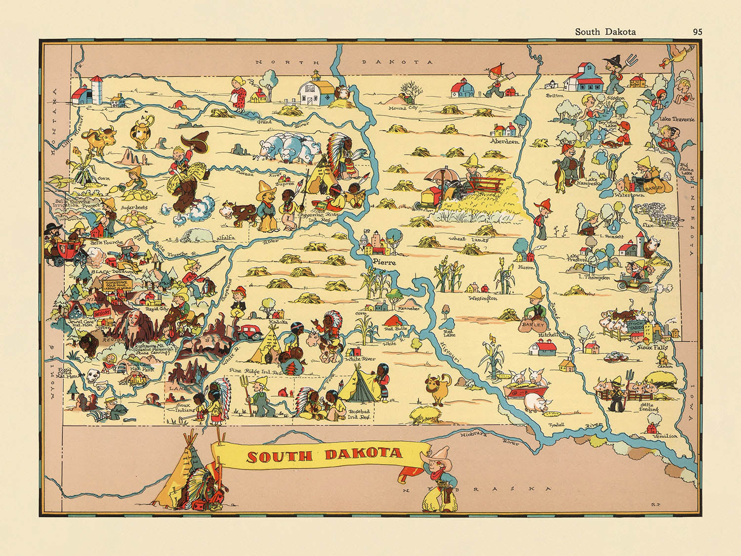
Betreten Sie die skurrile Welt des amerikanischen Lebens der 1930er Jahre mit „South Dakota“, dem ursprünglichen Titel dieser lebendigen bildlichen Karte, die...
WeiterlesenBetreten Sie die skurrile Welt des amerikanischen Lebens der 1930er Jahre mit „South Dakota“, dem ursprünglichen Titel dieser lebendigen bildlichen Karte, die 1935 von der gefeierten Ruth Taylor White erstellt wurde. Als Teil ihrer renommierten bildlichen Atlasreihe bietet diese Karte ein lebhaftes Tableau von South Dakota, das Geographie mit dem lebhaften Charakter seiner Menschen und Landschaften verbindet. Whites verspielte Kunst verwandelt den Staat in eine Leinwand aus Farben und Karikaturen und lädt die Betrachter ein, seine Landkreise, Grenzen und den geschichtsträchtigen Missouri River zu erkunden, der das Land elegant durchschneidet. Jedes Detail ist sorgfältig ausgearbeitet, von den sanften Hügeln bis zu den reichen landwirtschaftlichen Ebenen, und fängt das Wesen eines Staates ein, der im Herzen der amerikanischen Erfahrung liegt.
Ruth Taylor White, die kreative Kraft hinter dieser Karte, wurde für ihre Fähigkeit gefeiert, Kartografie mit Persönlichkeit und Humor zu versehen. Ihre Arbeiten überschritten die traditionellen Grenzen des Kartenmachens und verwandelten jedes Stück in ein narratives Gewebe, das sowohl Kinder als auch Erwachsene erfreute. In „South Dakota“ ist Whites einzigartiger Stil unverkennbar: kräftige Linien, lebendige Farben und animierte Figuren erwecken das Leben der Menschen, der Tierwelt und der Industrien des Staates. Ihre Illustrationen spiegeln nicht nur die Geographie wider, sondern auch den kulturellen Puls der Ära, wodurch ihre Karten bei Sammlern und Enthusiasten historischer Americana sehr begehrt sind.
Das Design der Karte ist ein Fest für die Augen und bietet eine harmonische Mischung aus thematischen und bildlichen Elementen. Die Landkreise von South Dakota sind deutlich abgebildet, jeder mit charmanten Vignetten geschmückt, die regionale Aktivitäten und lokale Farben hervorheben. Die Black Hills erheben sich in dramatischer Weise, Heimat des ikonischen Mount Rushmore, der liebevoll illustriert ist, um seine nationale Bedeutung zu unterstreichen. Die Badlands, mit ihren markanten Felsformationen, werden mit einem Gefühl des Staunens dargestellt, während die weiten Prärien mit Szenen von Viehzucht, Weizenanbau und dem majestätischen Bison, einem beständigen Symbol des amerikanischen Westens, wimmeln.
Historische und kulturelle Referenzen sind auf der Karte reichlich vorhanden und spiegeln die Faszination der Ära für sowohl Fortschritt als auch Erbe wider. Indigene amerikanische Motive und Figuren sind durchdacht integriert, um die indigenen Wurzeln des Staates und die beständige Präsenz seiner ersten Völker anzuerkennen. Bergbauaktivitäten in der Nähe der Black Hills, Szenen von Jagd und Angeln sowie Hinweise auf die robuste landwirtschaftliche Tradition des Staates zeichnen ein lebendiges Bild vom wirtschaftlichen und sozialen Leben South Dakotas zu Beginn des zwanzigsten Jahrhunderts. Der heitere Ton der Karte, vor dem Hintergrund der Großen Depression, vermittelt ein Gefühl von Optimismus und Widerstandsfähigkeit.
Die Städte und Gemeinden, die die Geschichte South Dakotas geprägt haben, verankern die Karte, von den geschäftigen Straßen von Sioux Falls und Rapid City bis zum historischen Charme von Pierre, Aberdeen und Brookings. Jede Siedlung ist sorgfältig beschriftet und spiegelt ihre Bedeutung in der modernen Landschaft des Staates wider. Die verspielte, aber präzise Darstellung dieser Gemeinschaften, eingebettet zwischen Flüssen, Bergen und offenen Ebenen, dient sowohl als Feier des Ortes als auch als historische Aufzeichnung. „South Dakota“ von Ruth Taylor White steht als Zeugnis für die beständige Kraft der kunstvollen Kartografie und lädt Sammler ein, ein Stück Geschichte zu besitzen, das ebenso bezaubernd wie informativ ist.
Städte und Gemeinden auf dieser Karte
- Sioux Falls
- Rapid City
- Aberdeen
- Brookings
- Watertown
- Mitchell
- Yankton
- Pierre (Landeshauptstadt)
- Huron
- Vermillion
- Spearfish
- Mobridge
- Madison
- Belle Fourche
- Chamberlain
- Winner
- Milbank
- Sisseton
- Hot Springs
- Lemmon
Bedeutende Merkmale & Wahrzeichen
- Der Missouri River ist prominent dargestellt und fließt durch den Bundesstaat.
- Die Region Black Hills wird mit bergigen Illustrationen und verwandten Bildern dargestellt.
- Der Mount Rushmore ist abgebildet, was seine Bedeutung als nationales Denkmal hervorhebt.
- Ureinwohnerfiguren und -motive sind dargestellt, die das indigene Erbe des Bundesstaates widerspiegeln.
- Landwirtschaftliche Szenen, wie Viehzucht und Weizenanbau, sind im ganzen Bundesstaat abgebildet.
- Bison (Büffel) werden gezeigt, was auf die Tierwelt und Geschichte der Region verweist.
- Bergbauaktivitäten sind im westlichen Teil des Bundesstaates dargestellt, insbesondere in der Nähe der Black Hills.
- Die Badlands sind mit dramatischen Felsformationen illustriert.
- Freizeitaktivitäten, wie Angeln und Jagen, werden gezeigt.
- Die Staatsgrenze ist deutlich markiert, während die benachbarten Staaten schwach angedeutet sind.
- Landkreisgrenzen und -namen sind auf der Karte beschriftet.
Historischer und gestalterischer Kontext
- Name der Karte: South Dakota
- Originaltitel: South Dakota.
- Erstellungsdatum: 1935
- Kartograf: Ruth Taylor White
- Verlag/Kontext: Die Karte ist Teil eines skurrilen bildlichen Atlas der Vereinigten Staaten, bekannt für seine ansprechenden und bunten Illustrationen.
- Stil: Thematische und bildliche Karte von Landkreis oder Bundesstaat, gekennzeichnet durch verspielte, cartoonartige Kunstwerke.
- Künstlerischer Zweck: Die Karte verwendet charmante und humorvolle Illustrationen, um den Geist, die Kultur und die Stereotypen von South Dakota in den 1930er Jahren einzufangen.
- Thematischer Fokus: Die Karte hebt regionale Aktivitäten, Industrien und kulturelle Elemente hervor, die sowohl die Geografie als auch den sozialen Charakter des Bundesstaates widerspiegeln.
- Gestaltungselemente: Die Karte zeigt lebendige Farben, übertriebene Figuren und lebhafte Szenen, was sie visuell ansprechend und zugänglich macht.
- Historischer Kontext: In der Zeit der Großen Depression erstellt, bietet die Karte eine heitere Perspektive auf das amerikanische Leben und die Identität und dient sowohl der Unterhaltung als auch der Bildung.
- Sammlerwert: Diese Karte wird als einzigartiges Stück Americana angesehen und ist bei Sammlern historischer Karten und bildlicher Atlanten begehrt.
- Bemerkenswerter Mangel: Die Karte konzentriert sich nicht auf präzise geografische Genauigkeit, sondern auf thematische und kulturelle Darstellung.
Bitte überprüfen Sie die Bilder, um sicherzustellen, dass eine bestimmte Stadt oder ein Ort auf dieser Karte gezeigt wird. Sie können uns auch kontaktieren und bitten, die Karte für Sie zu überprüfen.
Diese Karte sieht in jeder Größe großartig aus, aber ich empfehle immer, eine größere Größe zu wählen, wenn Sie Platz haben. So können Sie alle Details leicht erkennen.
Diese Karte sieht in Größen bis zu 50 Zoll (125 cm) erstaunlich aus. Wenn Sie nach einer größeren Karte suchen, bitte kontaktieren Sie uns.
Das Modell in den Abbildungsbildern hält die 18x24 Zoll (45x60 cm) Version dieser Karte.
Das fünfte Abbildungsbild zeigt ein Beispiel für meinen Personalisierungsservice für Karten.
Wenn Sie nach etwas leicht anderem suchen, schauen Sie sich meine Sammlung der besten alten Karten an, um zu sehen, ob etwas anderes Ihr Interesse weckt.
Bitte kontaktieren Sie mich, um zu überprüfen, ob ein bestimmter Standort, ein Wahrzeichen oder ein Merkmal auf dieser Karte dargestellt ist.
Dies wäre ein wunderbares Geschenk zum Geburtstag, Weihnachten, Vatertag, zum Verlassen der Arbeit, zum Jubiläum oder zur Einweihung für jemanden aus den in dieser Karte abgedeckten Bereichen.
Diese Karte ist als Giclée-Druck auf säurefreiem, archivfestem mattem Papier erhältlich, oder Sie können sie gerahmt kaufen. Der Rahmen ist ein schöner, einfacher schwarzer Rahmen, der zu den meisten Ästhetiken passt. Bitte kontaktieren Sie mich, wenn Sie eine andere Rahmenfarbe oder -material wünschen. Meine Rahmen sind mit superklarem, museumsgüte Acryl (Perspex/Acrylit) verglast, das deutlich weniger reflektierend ist als Glas, sicherer ist und immer in perfektem Zustand ankommt.
This map is also available as a float framed canvas, sometimes known as a shadow gap framed canvas or canvas floater. The map is printed on artist's cotton canvas and then stretched over a handmade box frame. We then "float" the canvas inside a wooden frame, which is available in a range of colours (black, dark brown, oak, antique gold and white). This is a wonderful way to present a map without glazing in front. See some examples of float framed canvas maps and explore the differences between my different finishes.
For something truly unique, this map is also available in "Unique 3D", our trademarked process that dramatically transforms the map so that it has a wonderful sense of depth. We combine the original map with detailed topography and elevation data, so that mountains and the terrain really "pop". For more info and examples of 3D maps, check my Unique 3D page.
Betreten Sie die skurrile Welt des amerikanischen Lebens der 1930er Jahre mit „South Dakota“, dem ursprünglichen Titel dieser lebendigen bildlichen Karte, die 1935 von der gefeierten Ruth Taylor White erstellt wurde. Als Teil ihrer renommierten bildlichen Atlasreihe bietet diese Karte ein lebhaftes Tableau von South Dakota, das Geographie mit dem lebhaften Charakter seiner Menschen und Landschaften verbindet. Whites verspielte Kunst verwandelt den Staat in eine Leinwand aus Farben und Karikaturen und lädt die Betrachter ein, seine Landkreise, Grenzen und den geschichtsträchtigen Missouri River zu erkunden, der das Land elegant durchschneidet. Jedes Detail ist sorgfältig ausgearbeitet, von den sanften Hügeln bis zu den reichen landwirtschaftlichen Ebenen, und fängt das Wesen eines Staates ein, der im Herzen der amerikanischen Erfahrung liegt.
Ruth Taylor White, die kreative Kraft hinter dieser Karte, wurde für ihre Fähigkeit gefeiert, Kartografie mit Persönlichkeit und Humor zu versehen. Ihre Arbeiten überschritten die traditionellen Grenzen des Kartenmachens und verwandelten jedes Stück in ein narratives Gewebe, das sowohl Kinder als auch Erwachsene erfreute. In „South Dakota“ ist Whites einzigartiger Stil unverkennbar: kräftige Linien, lebendige Farben und animierte Figuren erwecken das Leben der Menschen, der Tierwelt und der Industrien des Staates. Ihre Illustrationen spiegeln nicht nur die Geographie wider, sondern auch den kulturellen Puls der Ära, wodurch ihre Karten bei Sammlern und Enthusiasten historischer Americana sehr begehrt sind.
Das Design der Karte ist ein Fest für die Augen und bietet eine harmonische Mischung aus thematischen und bildlichen Elementen. Die Landkreise von South Dakota sind deutlich abgebildet, jeder mit charmanten Vignetten geschmückt, die regionale Aktivitäten und lokale Farben hervorheben. Die Black Hills erheben sich in dramatischer Weise, Heimat des ikonischen Mount Rushmore, der liebevoll illustriert ist, um seine nationale Bedeutung zu unterstreichen. Die Badlands, mit ihren markanten Felsformationen, werden mit einem Gefühl des Staunens dargestellt, während die weiten Prärien mit Szenen von Viehzucht, Weizenanbau und dem majestätischen Bison, einem beständigen Symbol des amerikanischen Westens, wimmeln.
Historische und kulturelle Referenzen sind auf der Karte reichlich vorhanden und spiegeln die Faszination der Ära für sowohl Fortschritt als auch Erbe wider. Indigene amerikanische Motive und Figuren sind durchdacht integriert, um die indigenen Wurzeln des Staates und die beständige Präsenz seiner ersten Völker anzuerkennen. Bergbauaktivitäten in der Nähe der Black Hills, Szenen von Jagd und Angeln sowie Hinweise auf die robuste landwirtschaftliche Tradition des Staates zeichnen ein lebendiges Bild vom wirtschaftlichen und sozialen Leben South Dakotas zu Beginn des zwanzigsten Jahrhunderts. Der heitere Ton der Karte, vor dem Hintergrund der Großen Depression, vermittelt ein Gefühl von Optimismus und Widerstandsfähigkeit.
Die Städte und Gemeinden, die die Geschichte South Dakotas geprägt haben, verankern die Karte, von den geschäftigen Straßen von Sioux Falls und Rapid City bis zum historischen Charme von Pierre, Aberdeen und Brookings. Jede Siedlung ist sorgfältig beschriftet und spiegelt ihre Bedeutung in der modernen Landschaft des Staates wider. Die verspielte, aber präzise Darstellung dieser Gemeinschaften, eingebettet zwischen Flüssen, Bergen und offenen Ebenen, dient sowohl als Feier des Ortes als auch als historische Aufzeichnung. „South Dakota“ von Ruth Taylor White steht als Zeugnis für die beständige Kraft der kunstvollen Kartografie und lädt Sammler ein, ein Stück Geschichte zu besitzen, das ebenso bezaubernd wie informativ ist.
Städte und Gemeinden auf dieser Karte
- Sioux Falls
- Rapid City
- Aberdeen
- Brookings
- Watertown
- Mitchell
- Yankton
- Pierre (Landeshauptstadt)
- Huron
- Vermillion
- Spearfish
- Mobridge
- Madison
- Belle Fourche
- Chamberlain
- Winner
- Milbank
- Sisseton
- Hot Springs
- Lemmon
Bedeutende Merkmale & Wahrzeichen
- Der Missouri River ist prominent dargestellt und fließt durch den Bundesstaat.
- Die Region Black Hills wird mit bergigen Illustrationen und verwandten Bildern dargestellt.
- Der Mount Rushmore ist abgebildet, was seine Bedeutung als nationales Denkmal hervorhebt.
- Ureinwohnerfiguren und -motive sind dargestellt, die das indigene Erbe des Bundesstaates widerspiegeln.
- Landwirtschaftliche Szenen, wie Viehzucht und Weizenanbau, sind im ganzen Bundesstaat abgebildet.
- Bison (Büffel) werden gezeigt, was auf die Tierwelt und Geschichte der Region verweist.
- Bergbauaktivitäten sind im westlichen Teil des Bundesstaates dargestellt, insbesondere in der Nähe der Black Hills.
- Die Badlands sind mit dramatischen Felsformationen illustriert.
- Freizeitaktivitäten, wie Angeln und Jagen, werden gezeigt.
- Die Staatsgrenze ist deutlich markiert, während die benachbarten Staaten schwach angedeutet sind.
- Landkreisgrenzen und -namen sind auf der Karte beschriftet.
Historischer und gestalterischer Kontext
- Name der Karte: South Dakota
- Originaltitel: South Dakota.
- Erstellungsdatum: 1935
- Kartograf: Ruth Taylor White
- Verlag/Kontext: Die Karte ist Teil eines skurrilen bildlichen Atlas der Vereinigten Staaten, bekannt für seine ansprechenden und bunten Illustrationen.
- Stil: Thematische und bildliche Karte von Landkreis oder Bundesstaat, gekennzeichnet durch verspielte, cartoonartige Kunstwerke.
- Künstlerischer Zweck: Die Karte verwendet charmante und humorvolle Illustrationen, um den Geist, die Kultur und die Stereotypen von South Dakota in den 1930er Jahren einzufangen.
- Thematischer Fokus: Die Karte hebt regionale Aktivitäten, Industrien und kulturelle Elemente hervor, die sowohl die Geografie als auch den sozialen Charakter des Bundesstaates widerspiegeln.
- Gestaltungselemente: Die Karte zeigt lebendige Farben, übertriebene Figuren und lebhafte Szenen, was sie visuell ansprechend und zugänglich macht.
- Historischer Kontext: In der Zeit der Großen Depression erstellt, bietet die Karte eine heitere Perspektive auf das amerikanische Leben und die Identität und dient sowohl der Unterhaltung als auch der Bildung.
- Sammlerwert: Diese Karte wird als einzigartiges Stück Americana angesehen und ist bei Sammlern historischer Karten und bildlicher Atlanten begehrt.
- Bemerkenswerter Mangel: Die Karte konzentriert sich nicht auf präzise geografische Genauigkeit, sondern auf thematische und kulturelle Darstellung.
Bitte überprüfen Sie die Bilder, um sicherzustellen, dass eine bestimmte Stadt oder ein Ort auf dieser Karte gezeigt wird. Sie können uns auch kontaktieren und bitten, die Karte für Sie zu überprüfen.
Diese Karte sieht in jeder Größe großartig aus, aber ich empfehle immer, eine größere Größe zu wählen, wenn Sie Platz haben. So können Sie alle Details leicht erkennen.
Diese Karte sieht in Größen bis zu 50 Zoll (125 cm) erstaunlich aus. Wenn Sie nach einer größeren Karte suchen, bitte kontaktieren Sie uns.
Das Modell in den Abbildungsbildern hält die 18x24 Zoll (45x60 cm) Version dieser Karte.
Das fünfte Abbildungsbild zeigt ein Beispiel für meinen Personalisierungsservice für Karten.
Wenn Sie nach etwas leicht anderem suchen, schauen Sie sich meine Sammlung der besten alten Karten an, um zu sehen, ob etwas anderes Ihr Interesse weckt.
Bitte kontaktieren Sie mich, um zu überprüfen, ob ein bestimmter Standort, ein Wahrzeichen oder ein Merkmal auf dieser Karte dargestellt ist.
Dies wäre ein wunderbares Geschenk zum Geburtstag, Weihnachten, Vatertag, zum Verlassen der Arbeit, zum Jubiläum oder zur Einweihung für jemanden aus den in dieser Karte abgedeckten Bereichen.
Diese Karte ist als Giclée-Druck auf säurefreiem, archivfestem mattem Papier erhältlich, oder Sie können sie gerahmt kaufen. Der Rahmen ist ein schöner, einfacher schwarzer Rahmen, der zu den meisten Ästhetiken passt. Bitte kontaktieren Sie mich, wenn Sie eine andere Rahmenfarbe oder -material wünschen. Meine Rahmen sind mit superklarem, museumsgüte Acryl (Perspex/Acrylit) verglast, das deutlich weniger reflektierend ist als Glas, sicherer ist und immer in perfektem Zustand ankommt.
This map is also available as a float framed canvas, sometimes known as a shadow gap framed canvas or canvas floater. The map is printed on artist's cotton canvas and then stretched over a handmade box frame. We then "float" the canvas inside a wooden frame, which is available in a range of colours (black, dark brown, oak, antique gold and white). This is a wonderful way to present a map without glazing in front. See some examples of float framed canvas maps and explore the differences between my different finishes.
For something truly unique, this map is also available in "Unique 3D", our trademarked process that dramatically transforms the map so that it has a wonderful sense of depth. We combine the original map with detailed topography and elevation data, so that mountains and the terrain really "pop". For more info and examples of 3D maps, check my Unique 3D page.
Many of our maps and art prints are chosen as thoughtful gifts for homes, offices, studies and meaningful places.
Choose a framed option for the easiest ready-to-hang gift, or choose an unframed print if the recipient may prefer to select their own frame.
We make orders locally in 23 countries around the world, so gifts can often be produced close to the recipient. This helps them arrive faster, travel more safely, and avoid customs or import duty surprises.
- We can deliver directly to the recipient
- Framed pieces arrive ready to hang
- Unframed prints are carefully packed in a strong protective tube
- Almost every order is made locally, for faster, safer gifting
- 90-day returns give the recipient time to decide
If you are not sure what to choose, please contact us. We can help you pick the right map, size, finish or delivery option.
Für die meisten Bestellungen beträgt die Lieferzeit etwa 3 Werktage. Personalisierte und maßgeschneiderte Produkte benötigen länger, da ich die Personalisierung durchführen und sie Ihnen zur Genehmigung zusenden muss, was normalerweise 1 oder 2 Tage dauert.
Bitte beachten Sie, dass sehr große gerahmte Bestellungen in der Regel länger für die Herstellung und Lieferung benötigen.
Wenn Sie möchten, dass Ihre Bestellung bis zu einem bestimmten Datum ankommt, bitte kontaktieren Sie mich, bevor Sie bestellen, damit wir den besten Weg finden können, um sicherzustellen, dass Sie Ihre Bestellung rechtzeitig erhalten.
Ich drucke und rahme Karten und Kunstwerke in 23 Ländern weltweit. Das bedeutet, dass Ihre Bestellung lokal gefertigt wird, was die Lieferzeit verkürzt und sicherstellt, dass sie während der Lieferung nicht beschädigt wird. Sie zahlen nie Zoll oder Einfuhrgebühren, und wir stoßen weniger CO2 in die Luft aus.
Alle meine Karten und Kunstdrucke sind gut verpackt und werden in einem robusten Rohr versendet, wenn sie ungerahmt sind, oder von Schaum umgeben, wenn sie gerahmt sind.
Ich versuche, alle Bestellungen innerhalb von 1 oder 2 Tagen nach Erhalt Ihrer Bestellung zu versenden, obwohl einige Produkte (wie Gesichtsmasken, Tassen und Tragetaschen) länger zur Herstellung benötigen können.
Wenn Sie Express-Lieferung an der Kasse auswählen, priorisieren wir Ihre Bestellung und versenden sie per 1-Tages-Kurier (Fedex, DHL, UPS, Parcelforce).
Nächster Tag Lieferung ist auch in einigen Ländern verfügbar (USA, UK, Singapur, VAE), aber bitte versuchen Sie, früh am Tag zu bestellen, damit wir es rechtzeitig versenden können.
Lesen Sie meinen vollständigen Leitfaden zur Lieferung und lokalen Produktion
Mein Standardrahmen ist ein Galerie-Stil-Rahmen aus schwarzem Eschenholz. Er ist einfach und sieht ziemlich modern aus. Mein Standardrahmen ist etwa 20 mm (0,8 Zoll) breit.
Ich verwende super-klares Acryl (Plexiglas/Acrylt) für das Glas des Rahmens. Es ist leichter und sicherer als Glas – und es sieht besser aus, da die Reflexion geringer ist.
Sechs Standardrahmenfarben sind kostenlos erhältlich (schwarz, dunkelbraun, dunkelgrau, Eiche, weiß und antikgold).
Die meisten Karten, Kunstwerke und Illustrationen sind auch als gerahmte Leinwand erhältlich. Wir verwenden matte (nicht glänzende) Baumwollleinwand, spannen sie über einen nachhaltig beschafften Buchenrahmen und 'schweben' dann das Stück innerhalb eines Holzrahmens. Das Endergebnis ist ziemlich schön, und es gibt keine Verglasung, die im Weg ist.
Alle Rahmen werden "bereit zum Aufhängen" geliefert, entweder mit einer Schnur oder Halterungen auf der Rückseite. Sehr große Rahmen haben schwere Aufhängeplatten und/oder eine Montageschiene. Wenn Sie Fragen haben, können Sie bitte Kontakt aufnehmen.
Sehen Sie sich einige Beispiele meiner gerahmten Karten und gerahmten Leinwandkarten an.
Alternativ kann ich auch alte Karten und Kunstwerke auf Leinwand, Schaumstoffplatten, Baumwollrag und andere Materialien liefern.
Wenn Sie Ihre Karte oder Ihr Kunstwerk selbst rahmen möchten, lesen Sie bitte zuerst meinen Größenleitfaden.
Meine Karten sind äußerst hochwertige Reproduktionen von Originalkarten.
Ich beziehe originale, seltene Karten aus Bibliotheken, Auktionshäusern und Privatsammlungen auf der ganzen Welt, restauriere sie in meiner Londoner Werkstatt und erstelle dann mit speziellen Giclée-Tinten und -Druckern wunderschöne Karten, die sogar noch besser aussehen als das Original.
Meine Karten werden auf säurefreiem, mattem Archivpapier (nicht glänzend) gedruckt, das sich sehr hochwertig anfühlt und fast wie Karton aussieht. Technisch gesehen beträgt das Papiergewicht/die Papierdicke 10mil/200g/m². Es eignet sich perfekt zum Einrahmen.
Ich drucke mit UV-lichtbeständigen Ultrachrome-Giclée-Pigmenttinten von Epson – einige der besten Tinten, die Sie finden können.
Ich kann auch machen Karten auf Leinwand, Baumwolllappen und andere exotische Materialien.
Erfahren Sie mehr über The Unique Maps Co.
Kartenpersonalisierung
Wenn Sie nach dem perfekten Geschenk zum Jahrestag oder zur Einweihung suchen, kann ich Ihre Karte personalisieren, um sie wirklich einzigartig zu machen. Ich kann beispielsweise eine kurze Nachricht hinzufügen, einen wichtigen Ort hervorheben oder das Wappen Ihrer Familie hinzufügen.
Die Möglichkeiten sind nahezu unbegrenzt. Bitte sehen Sie sich meine Kartenpersonalisierungsseite für einige wunderbare Beispiele dessen, was möglich ist.
Um eine personalisierte Karte zu bestellen, wählen Sie „Personalisieren Sie Ihre Karte“, bevor Sie sie in den Warenkorb legen.
In Kontakt kommen wenn Sie nach komplexeren Anpassungen und Personalisierungen suchen.
Kartenalterung
Im Laufe der Jahre wurde ich von Kunden hunderte Male gefragt, ob sie eine Karte kaufen könnten, die noch älter.
Nun, jetzt können Sie das, indem Sie „Alter“ auswählen, bevor Sie eine Karte in Ihren Warenkorb legen.
Alle Produktfotos, die Sie auf dieser Seite sehen, zeigen die Karte in ihrer Originalform. So sieht die Karte heute aus.
Wenn Sie „Gealtert“ auswählen, werde ich Ihre Karte von Hand altern lassen. Dazu verwende ich ein spezielles und einzigartiges Verfahren, das ich durch jahrelanges Studium alter Karten und Gespräche mit Forschern zum Verständnis der Chemie alternder Papiere entwickelt habe, und natürlich ... viel Übung!
Wenn Sie sich nicht sicher sind, bleiben Sie bei der Originalfarbe der Karte. Wenn Sie etwas Dunkleres und älter Wenn Sie auf der Suche sind, entscheiden Sie sich für „Aged“.
Sehen Sie einige erstaunliche Beispiele für gealterte Karten.
Wenn Sie aus irgendeinem Grund mit Ihrer Bestellung nicht zufrieden sind, kontaktieren Sie mich für eine unkomplizierte Rückerstattung. Bitte sehen Sie sich unsere Rückgabe- und Rückerstattungsrichtlinien für weitere Informationen an.
Ich bin sehr zuversichtlich, dass Ihnen Ihre restaurierte Karte oder Kunstdruck gefallen wird. Ich mache das seit 1984. Ich bin ein 5-Sterne Etsy-Verkäufer. Ich habe Zehntausende von Karten und Kunstdrucken verkauft und habe über 5.000 echte 5-Sterne-Bewertungen.
Ich verwende einen einzigartigen Prozess, um Karten und Kunstwerke zu restaurieren, der extrem zeitaufwendig und arbeitsintensiv ist. Die Suche nach den Originalkarten und Illustrationen kann Monate dauern. Ich benutze modernste und unglaublich teure Technologie, um sie zu scannen und wiederherzustellen. Daher garantiere ich, dass meine Karten und Kunstdrucke eine Klasse für sich sind - deshalb kann ich eine unkomplizierte Rückerstattung anbieten.
Fast alle meine Karten und Kunstdrucke sehen in großen Größen (200 cm, 6,5 Fuß+) erstaunlich aus und ich kann sie Ihnen auch gerahmt und über einen speziellen Übergrößen-Kurier liefern. Kontaktieren Sie mich, um Ihre speziellen Bedürfnisse zu besprechen.
Or try searching for something!


