

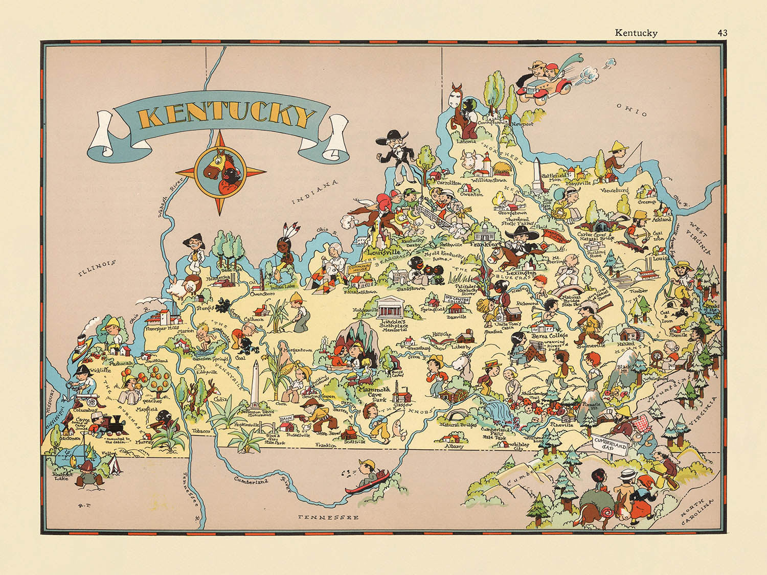


Bildkarte von Kentucky von Ruth Taylor White, 1935: Louisville, Lexington, Pferderennen, Bourbon, Appalachen
Kaufe 2, Erhalte 1 Kostenlos
Wenn Sie 2 Artikel in Ihren Warenkorb legen, können Sie ein drittes Produkt kostenlos hinzufügen.
Dies gilt für alle Karten und Kunstwerke, einschließlich individuell gestalteter und personalisierter Stücke. Sie können 3 von derselben Sache oder 3 verschiedene Dinge bestellen.
Das entspricht einem Rabatt von 33 %, der in diesem Jahr der größte Rabatt in meinem Shop sein wird.
Bitte nutzen Sie das Angebot und dekorieren Sie Ihre Wände mit schönen Karten und Kunst!
Kontaktieren Sie mich, wenn Sie Fragen haben.

-
![]() Handmade in Australia
Handmade in Australia
-
Free delivery &
usually dispatched next day
Dispatched next working day
Your map should be dispatched the next working day.
Deliveries over the Christmas and New Year period may be slightly delayed, as couriers and postal services catch up with a huge backlog of packages.
Express delivery is available at checkout.
If you need your order to arrive by a certain date, contact me and we can discuss your options.
Please note that personalised maps, and some larger framed maps can take longer to produce and deliver.
-
FREE gift preview
ⓘ
Digital gift preview
After you complete your order, you can send a beautiful digital preview to the gift recipient. Just provide their email address and we'll do the rest. (Their email address will not be stored or used for any other purpose.)
This is perfect if you're concerned that your order might not arrive in time.
You can also buy a real non-expiring gift card, and email it directly to the recipient, so they can buy their own map or artwork.
-
90 day money back guarantee
ⓘ
90 Tage für Rückgabe und Rückerstattung
Produkte können innerhalb von 90 Tagen für eine vollständige Rückerstattung oder einen Umtausch gegen ein anderes Produkt zurückgegeben werden.
Für personalisierte und maßgefertigte Artikel können wir Ihnen möglicherweise einen Gutschein oder eine nicht ablaufende Geschenkkarte anbieten, da wir personalisierte Bestellungen nicht weiterverkaufen können.
Wenn Sie Fragen haben, kontaktieren Sie uns. Für weitere Informationen siehe unsere vollständige Rückgabe- und Umtauschrichtlinie.

My maps are rare, museum-grade, restored old maps sourced from libraries, auction houses and private collections across the globe.
Framing & free personalisation available
1. Select your size
Click here to order a custom size.
2. Frame & personalise your map
Make your map unique with framing, hand-drawn customisation, vintage ageing, pop art text, unique 3D styling and more.


Geschenkmitteilung & individuelle Ausführung

Wenn Sie eine Geschenkmitteilung oder eine Ausführung (Puzzle, Aluminiumplatte usw.) hinzufügen möchten, die hier nicht verfügbar ist, geben Sie dies bitte in der "Bestellnotiz" beim Checkout an.
Jede Bestellung wird individuell angefertigt. Wenn Sie die Größe leicht anpassen oder auf einem ungewöhnlichen Material drucken lassen möchten, lassen Sie es uns einfach wissen. Wir haben im Laufe der Jahre Tausende von individuellen Bestellungen bearbeitet, daher gibt es (fast) nichts, was wir nicht bewältigen können.
Sie können uns auch kontaktieren, bevor Sie bestellen, wenn Sie möchten!

- Handmade locally. No import duty or tax
- FREE worldwide delivery
- Love it or your money back (90 days)
- Questions? WhatsApp me any time
Own a piece of history
5,000+ 5 star reviews


Betreten Sie die lebendige Welt der amerikanischen 1930er Jahre mit „Kentucky“, dem ursprünglichen Titel dieser faszinierenden bildlichen Karte, die 1935 von Ruth Taylor White erstellt wurde. Weit mehr als ein bloßer geografischer Bezug, ist diese Karte eine Feier des einzigartigen Charakters von Kentucky, dargestellt in einem skurrilen, cartoonhaften Stil, der sofort ins Auge fällt. Jedes County ist umreißt und beschriftet, aber es sind die bunten Illustrationen – die alles von lebhaften Pferderennen bis zu geschäftigen Dampfschiffen darstellen – die den Bluegrass State wirklich zum Leben erwecken. Der dekorative Rand und die Titelkartusche der Karte verleihen ihr einen Hauch von verspielter Eleganz und machen sie zu einer entzückenden Fusion aus Kunst und kartografischer Tradition.
Ruth Taylor White, die Visionärin hinter dieser Karte, war bekannt für ihre Fähigkeit, Humor, Kunstfertigkeit und soziale Kommentierung in ihren bildlichen Werken zu verbinden. Häufig in Zusammenarbeit mit ihrem Ehemann, Frank Taylor, trug sie zu einer Reihe von fantasievollen Atlanten bei, die das Wesen der amerikanischen Bundesstaaten durch die Linse der Popkultur und lokalen Überlieferung einfingen. Ihre Karten sind nicht nur wegen ihrer ästhetischen Anziehungskraft geschätzt, sondern auch wegen ihrer aufschlussreichen Darstellung der regionalen Identitäten und Stereotypen der damaligen Zeit. „Kentucky“ steht als Zeugnis ihres Talents und bietet einen Einblick in die kulturelle Landschaft des Staates, wie sie zu Beginn des 20. Jahrhunderts wahrgenommen wurde.
Das Design der Karte ist eine Meisterklasse in thematischer Kartografie, wobei jede illustrierte Vignette ausgewählt wurde, um einen prägnanten Aspekt des Erbes von Kentucky hervorzuheben. Szenen von Vollblutpferden und Rennbahnen zollen den legendären reiterlichen Traditionen des Staates Tribut, während Darstellungen von Tabakscheunen und Bourbonfässern seine landwirtschaftlichen und destillierenden Fähigkeiten unterstreichen. Die Einbeziehung von Kohlenbergwerken und Appalachen-Gebirgen spricht für die Vielfalt der Wirtschaft und Geographie Kentuckys. Diese lebhaften Illustrationen verschönern nicht nur die Karte – sie erzählen die Geschichte einer Region, die von ihrem Land, ihrer Arbeit und ihrer Freizeit geprägt ist.
Was diese Karte auszeichnet, ist ihre Fähigkeit, die natürlichen und menschlichen Elemente Kentuckys sowohl mit Genauigkeit als auch mit Charme miteinander zu verweben. Große Flüsse wie der Ohio sind mit Radschleppern belebt, während die sanften Hügel und Täler des Staates mit Vieh und Musikern gespickt sind, die die Rhythmen der Bluegrass-Kultur hervorrufen. Anstatt sich auf spezifische historische Wahrzeichen oder Ereignisse zu konzentrieren, erfasst die Karte das breitere Gewebe des täglichen Lebens, von geschäftigen Städten bis zu ruhigen Farmlandschaften. Jede Szene ist mit einem Gefühl von Humor und Zuneigung dargestellt, was die Karte ebenso unterhaltsam zu erkunden macht wie informativ.
Die dargestellten Städte und Gemeinden – von Louisville und Lexington bis zu kleineren Gemeinschaften wie Hazard und Pineville – sind sorgfältig platziert und spiegeln die Siedlungsmuster des Staates in den 1930er Jahren wider. Ihre Präsenz verankert die fantasievollen Illustrationen der Karte in einer realen Geographie und lädt die Betrachter ein, die Konturen von Kentuckys Vergangenheit und Gegenwart nachzuvollziehen. Als historisches Artefakt ist „Kentucky“ mehr als nur eine Karte; es ist eine visuelle Erzählung, die Sammler und Enthusiasten gleichermaßen einlädt, den Geist einer vergangenen Ära zu erleben, in der Kunstfertigkeit und Kartografie in einer Feier von Ort und Identität zusammentreffen.
Städte und Gemeinden auf dieser Karte
- Louisville
- Lexington
- Bowling Green
- Owensboro
- Covington
- Hopkinsville
- Paducah
- Ashland
- Frankfort
- Henderson
- Winchester
- Somerset
- Middlesboro
- Mayfield
- Danville
- Hazard
- Pineville
Bemerkenswerte Merkmale & Wahrzeichen
- Illustrationen von Pferden und Pferderennen, die auf Kentuckys berühmte Pferdeindustrie verweisen.
- Darstellungen des Tabakanbaus und von Scheunen, die das agrarische Erbe des Staates hervorheben.
- Bilder von Bourbonfässern und Brennereien, die auf Kentuckys Bourbonindustrie verweisen.
- Cartoonfiguren in traditioneller Tracht, die die lokale Kultur und Folklore repräsentieren.
- Zeichnungen von Kohlenbergbauszenen, die die Bedeutung der Kohle für Kentuckys Wirtschaft anzeigen.
- Illustrationen von Dampfschiffen auf dem Ohio River, die auf Kentuckys Flusshandel verweisen.
- Künstlerische Darstellungen der Appalachen im östlichen Teil des Staates.
- Szenen von Bluegrass-Musik und Musikern, die auf Kentuckys musikalische Traditionen anspielen.
- Bilder von Vieh, wie Rindern und Schweinen, die die landwirtschaftlichen Aktivitäten des Staates widerspiegeln.
- Beschriftete Landkreisgrenzen und -namen, obwohl nicht alle auf den ersten Blick lesbar sind.
- Dekorativer Rand und Titelkartusche in einem verspielten Stil.
- Die Karte ist mit bunten, verspielten Illustrationen gefüllt, anstatt mit standardmäßigen Kartensymbolen.
Historischer und gestalterischer Kontext
- Name der Karte: Kentucky (ursprünglicher Titel: Kentucky.)
- Kartenmacherin: Ruth Taylor White, bekannt für ihre verspielten und künstlerischen bildlichen Karten.
- Erstellungsdatum: 1935.
- Teil eines fantasievollen bildlichen oder Cartoon-Atlas der Vereinigten Staaten, der Kunst, Humor und Geografie verbindet.
- Die Karte verwendet lebendige, cartoonartige Illustrationen, um stereotype und bemerkenswerte Szenen, Personen und Aktivitäten darzustellen, die mit Kentucky in den 1930er Jahren verbunden sind.
- Die Karte spiegelt die Wahrnehmungen und Stereotypen von Kentucky zu Beginn des 20. Jahrhunderts wider und bietet Einblicke, wie der Staat zu dieser Zeit kulturell und wirtschaftlich gesehen wurde.
- Die Karte dient sowohl als geografische Darstellung als auch als kulturelles Artefakt und fängt den Geist und die Identität Kentuckys in den 1930er Jahren ein.
- Die Karte ist ein Produkt ihrer Zeit und spiegelt den Humor, die Vorurteile und die künstlerischen Konventionen der 1930er Jahre wider.
- Die Karte ist Teil eines größeren Trends in den 1930er Jahren, bildliche Karten zu erstellen, die Kunst, Humor und Geografie verbinden.
- Die Karte ist ein charmantes Artefakt für Sammler und Interessierte an der Schnittstelle von Kunst und Kartografie.
Bitte überprüfen Sie die Bilder, um sicherzustellen, dass eine bestimmte Stadt oder ein bestimmter Ort auf dieser Karte gezeigt wird. Sie können uns auch kontaktieren und bitten, die Karte für Sie zu überprüfen.
Diese Karte sieht in jeder Größe großartig aus, aber ich empfehle immer, eine größere Größe zu wählen, wenn Sie Platz haben. So können Sie alle Details leicht erkennen.
Diese Karte sieht in Größen bis zu 50 Zoll (125 cm) erstaunlich aus. Wenn Sie nach einer größeren Karte suchen, bitte kontaktieren Sie uns.
Das Modell auf den Listing-Bildern hält die 18x24 Zoll (45x60 cm) Version dieser Karte.
Das fünfte Listing-Bild zeigt ein Beispiel für meinen Personalisierungsservice für Karten.
Wenn Sie nach etwas etwas anderem suchen, schauen Sie sich meine Sammlung der besten alten Karten an, um zu sehen, ob etwas anderes Ihr Interesse weckt.
Bitte kontaktieren Sie mich, um zu überprüfen, ob ein bestimmter Standort, ein Wahrzeichen oder ein Merkmal auf dieser Karte dargestellt ist.
Das wäre ein wunderbares Geburtstags-, Weihnachts-, Vatertags-, Abschieds-, Jubiläums- oder Einweihungsgeschenk für jemanden aus den in dieser Karte abgedeckten Gebieten.
Diese Karte ist als Giclée-Druck auf säurefreiem, archivierbarem mattem Papier erhältlich, oder Sie können sie gerahmt kaufen. Der Rahmen ist ein schöner, schlichter schwarzer Rahmen, der zu den meisten Ästhetiken passt. Bitte kontaktieren Sie mich, wenn Sie eine andere Rahmenfarbe oder -material wünschen. Meine Rahmen sind mit superklarem, museumstauglichem Acryl (Plexiglas/Acrylt) verglast, das deutlich weniger reflektierend als Glas ist, sicherer und immer in einwandfreiem Zustand ankommt.
This map is also available as a float framed canvas, sometimes known as a shadow gap framed canvas or canvas floater. The map is printed on artist's cotton canvas and then stretched over a handmade box frame. We then "float" the canvas inside a wooden frame, which is available in a range of colours (black, dark brown, oak, antique gold and white). This is a wonderful way to present a map without glazing in front. See some examples of float framed canvas maps and explore the differences between my different finishes.
For something truly unique, this map is also available in "Unique 3D", our trademarked process that dramatically transforms the map so that it has a wonderful sense of depth. We combine the original map with detailed topography and elevation data, so that mountains and the terrain really "pop". For more info and examples of 3D maps, check my Unique 3D page.
Für die meisten Bestellungen beträgt die Lieferzeit etwa 3 Werktage. Personalisierte und maßgeschneiderte Produkte benötigen länger, da ich die Personalisierung durchführen und sie Ihnen zur Genehmigung zusenden muss, was normalerweise 1 oder 2 Tage dauert.
Bitte beachten Sie, dass sehr große gerahmte Bestellungen in der Regel länger für die Herstellung und Lieferung benötigen.
Wenn Sie möchten, dass Ihre Bestellung bis zu einem bestimmten Datum ankommt, bitte kontaktieren Sie mich, bevor Sie bestellen, damit wir den besten Weg finden können, um sicherzustellen, dass Sie Ihre Bestellung rechtzeitig erhalten.
Ich drucke und rahme Karten und Kunstwerke in 23 Ländern weltweit. Das bedeutet, dass Ihre Bestellung lokal gefertigt wird, was die Lieferzeit verkürzt und sicherstellt, dass sie während der Lieferung nicht beschädigt wird. Sie zahlen nie Zoll oder Einfuhrgebühren, und wir stoßen weniger CO2 in die Luft aus.
Alle meine Karten und Kunstdrucke sind gut verpackt und werden in einem robusten Rohr versendet, wenn sie ungerahmt sind, oder von Schaum umgeben, wenn sie gerahmt sind.
Ich versuche, alle Bestellungen innerhalb von 1 oder 2 Tagen nach Erhalt Ihrer Bestellung zu versenden, obwohl einige Produkte (wie Gesichtsmasken, Tassen und Tragetaschen) länger zur Herstellung benötigen können.
Wenn Sie Express-Lieferung an der Kasse auswählen, priorisieren wir Ihre Bestellung und versenden sie per 1-Tages-Kurier (Fedex, DHL, UPS, Parcelforce).
Nächster Tag Lieferung ist auch in einigen Ländern verfügbar (USA, UK, Singapur, VAE), aber bitte versuchen Sie, früh am Tag zu bestellen, damit wir es rechtzeitig versenden können.
Lesen Sie meinen vollständigen Leitfaden zur Lieferung und lokalen Produktion
Mein Standardrahmen ist ein Galerie-Stil-Rahmen aus schwarzem Eschenholz. Er ist einfach und sieht ziemlich modern aus. Mein Standardrahmen ist etwa 20 mm (0,8 Zoll) breit.
Ich verwende super-klares Acryl (Plexiglas/Acrylt) für das Glas des Rahmens. Es ist leichter und sicherer als Glas – und es sieht besser aus, da die Reflexion geringer ist.
Sechs Standardrahmenfarben sind kostenlos erhältlich (schwarz, dunkelbraun, dunkelgrau, Eiche, weiß und antikgold).
Die meisten Karten, Kunstwerke und Illustrationen sind auch als gerahmte Leinwand erhältlich. Wir verwenden matte (nicht glänzende) Baumwollleinwand, spannen sie über einen nachhaltig beschafften Buchenrahmen und 'schweben' dann das Stück innerhalb eines Holzrahmens. Das Endergebnis ist ziemlich schön, und es gibt keine Verglasung, die im Weg ist.
Alle Rahmen werden "bereit zum Aufhängen" geliefert, entweder mit einer Schnur oder Halterungen auf der Rückseite. Sehr große Rahmen haben schwere Aufhängeplatten und/oder eine Montageschiene. Wenn Sie Fragen haben, können Sie bitte Kontakt aufnehmen.
Sehen Sie sich einige Beispiele meiner gerahmten Karten und gerahmten Leinwandkarten an.
Alternativ kann ich auch alte Karten und Kunstwerke auf Leinwand, Schaumstoffplatten, Baumwollrag und andere Materialien liefern.
Wenn Sie Ihre Karte oder Ihr Kunstwerk selbst rahmen möchten, lesen Sie bitte zuerst meinen Größenleitfaden.
Einige meiner alten Karten sind jetzt als gerahmte Leinwände erhältlich. Bitte kontaktiere mich, wenn du eine Größe bestellen möchtest, die in meinem Shop nicht verfügbar ist.
Leinwand alte Karten sind eine interessante Alternative zu konventionell gerahmten Karten. Je nach deinem persönlichen Geschmack und der Raumdekoration können Leinwandkarten etwas mehr „herausstechen“ als eine gerahmte Karte.
Meine Karten sind äußerst hochwertige Reproduktionen von Originalkarten.
Ich beziehe originale, seltene Karten aus Bibliotheken, Auktionshäusern und Privatsammlungen auf der ganzen Welt, restauriere sie in meiner Londoner Werkstatt und erstelle dann mit speziellen Giclée-Tinten und -Druckern wunderschöne Karten, die sogar noch besser aussehen als das Original.
Meine Karten werden auf säurefreiem, mattem Archivpapier (nicht glänzend) gedruckt, das sich sehr hochwertig anfühlt und fast wie Karton aussieht. Technisch gesehen beträgt das Papiergewicht/die Papierdicke 10mil/200g/m². Es eignet sich perfekt zum Einrahmen.
Ich drucke mit UV-lichtbeständigen Ultrachrome-Giclée-Pigmenttinten von Epson – einige der besten Tinten, die Sie finden können.
Ich kann auch machen Karten auf Leinwand, Baumwolllappen und andere exotische Materialien.
Erfahren Sie mehr über The Unique Maps Co.
Kartenpersonalisierung
Wenn Sie nach dem perfekten Geschenk zum Jahrestag oder zur Einweihung suchen, kann ich Ihre Karte personalisieren, um sie wirklich einzigartig zu machen. Ich kann beispielsweise eine kurze Nachricht hinzufügen, einen wichtigen Ort hervorheben oder das Wappen Ihrer Familie hinzufügen.
Die Möglichkeiten sind nahezu unbegrenzt. Bitte sehen Sie sich meine Kartenpersonalisierungsseite für einige wunderbare Beispiele dessen, was möglich ist.
Um eine personalisierte Karte zu bestellen, wählen Sie „Personalisieren Sie Ihre Karte“, bevor Sie sie in den Warenkorb legen.
In Kontakt kommen wenn Sie nach komplexeren Anpassungen und Personalisierungen suchen.
Kartenalterung
Im Laufe der Jahre wurde ich von Kunden hunderte Male gefragt, ob sie eine Karte kaufen könnten, die noch älter.
Nun, jetzt können Sie das, indem Sie „Alter“ auswählen, bevor Sie eine Karte in Ihren Warenkorb legen.
Alle Produktfotos, die Sie auf dieser Seite sehen, zeigen die Karte in ihrer Originalform. So sieht die Karte heute aus.
Wenn Sie „Gealtert“ auswählen, werde ich Ihre Karte von Hand altern lassen. Dazu verwende ich ein spezielles und einzigartiges Verfahren, das ich durch jahrelanges Studium alter Karten und Gespräche mit Forschern zum Verständnis der Chemie alternder Papiere entwickelt habe, und natürlich ... viel Übung!
Wenn Sie sich nicht sicher sind, bleiben Sie bei der Originalfarbe der Karte. Wenn Sie etwas Dunkleres und älter Wenn Sie auf der Suche sind, entscheiden Sie sich für „Aged“.
Sehen Sie einige erstaunliche Beispiele für gealterte Karten.
Wenn Sie aus irgendeinem Grund mit Ihrer Bestellung nicht zufrieden sind, kontaktieren Sie mich für eine unkomplizierte Rückerstattung. Bitte sehen Sie sich unsere Rückgabe- und Rückerstattungsrichtlinien für weitere Informationen an.
Ich bin sehr zuversichtlich, dass Ihnen Ihre restaurierte Karte oder Kunstdruck gefallen wird. Ich mache das seit 1984. Ich bin ein 5-Sterne Etsy-Verkäufer. Ich habe Zehntausende von Karten und Kunstdrucken verkauft und habe über 5.000 echte 5-Sterne-Bewertungen.
Ich verwende einen einzigartigen Prozess, um Karten und Kunstwerke zu restaurieren, der extrem zeitaufwendig und arbeitsintensiv ist. Die Suche nach den Originalkarten und Illustrationen kann Monate dauern. Ich benutze modernste und unglaublich teure Technologie, um sie zu scannen und wiederherzustellen. Daher garantiere ich, dass meine Karten und Kunstdrucke eine Klasse für sich sind - deshalb kann ich eine unkomplizierte Rückerstattung anbieten.
Fast alle meine Karten und Kunstdrucke sehen in großen Größen (200 cm, 6,5 Fuß+) erstaunlich aus und ich kann sie Ihnen auch gerahmt und über einen speziellen Übergrößen-Kurier liefern. Kontaktieren Sie mich, um Ihre speziellen Bedürfnisse zu besprechen.
Or try searching for something!


