


Bildkarte von Georgia von Ruth Taylor White, 1935: Atlanta, Savannah, Augusta, Macon, Flussboote
20% Rabatt auf 2 — 33% Rabatt auf 3
Fügen Sie beliebige zwei berechtigte Artikel zu Ihrem Warenkorb hinzu, um 20% Rabatt zu erhalten. Fügen Sie einen dritten hinzu und er ist kostenlos (entspricht 33% Rabatt, wenn Sie drei kaufen).
Kein Code erforderlich — das Angebot wird automatisch an der Kasse angewendet.
Gültig für alle Standardkarten und Kunstdrucke. Sie können beliebige Designs kombinieren.
Wenn Sie Artikel an mehrere Adressen versenden möchten, kontaktieren Sie uns bitte, bevor Sie Ihre Bestellung aufgeben.
Maßanfertigungen und individuelle Aufträge sind ausgeschlossen.
Kontaktieren Sie uns wenn Sie Fragen haben
 In London gestaltet Hergestellt in Australia
In London gestaltet • Hergestellt in Australia
In London gestaltet Hergestellt in Australia
In London gestaltet • Hergestellt in Australia

Choose your size
Choose your finish


(Mehr Infos)
Geschenkmitteilung & individuelle Ausführung

Wenn Sie eine Geschenkmitteilung oder eine Ausführung (Puzzle, Aluminiumplatte usw.) hinzufügen möchten, die hier nicht verfügbar ist, geben Sie dies bitte in der "Bestellnotiz" beim Checkout an.
Jede Bestellung wird individuell angefertigt. Wenn Sie die Größe leicht anpassen oder auf einem ungewöhnlichen Material drucken lassen möchten, lassen Sie es uns einfach wissen. Wir haben im Laufe der Jahre Tausende von individuellen Bestellungen bearbeitet, daher gibt es (fast) nichts, was wir nicht bewältigen können.
Sie können uns auch kontaktieren, bevor Sie bestellen, wenn Sie möchten!

- Made locally for fast, safe delivery
- No import duty or hidden fees
- Need advice? Message us on WhatsApp
Own a piece of history
7,000+ 5 star reviews


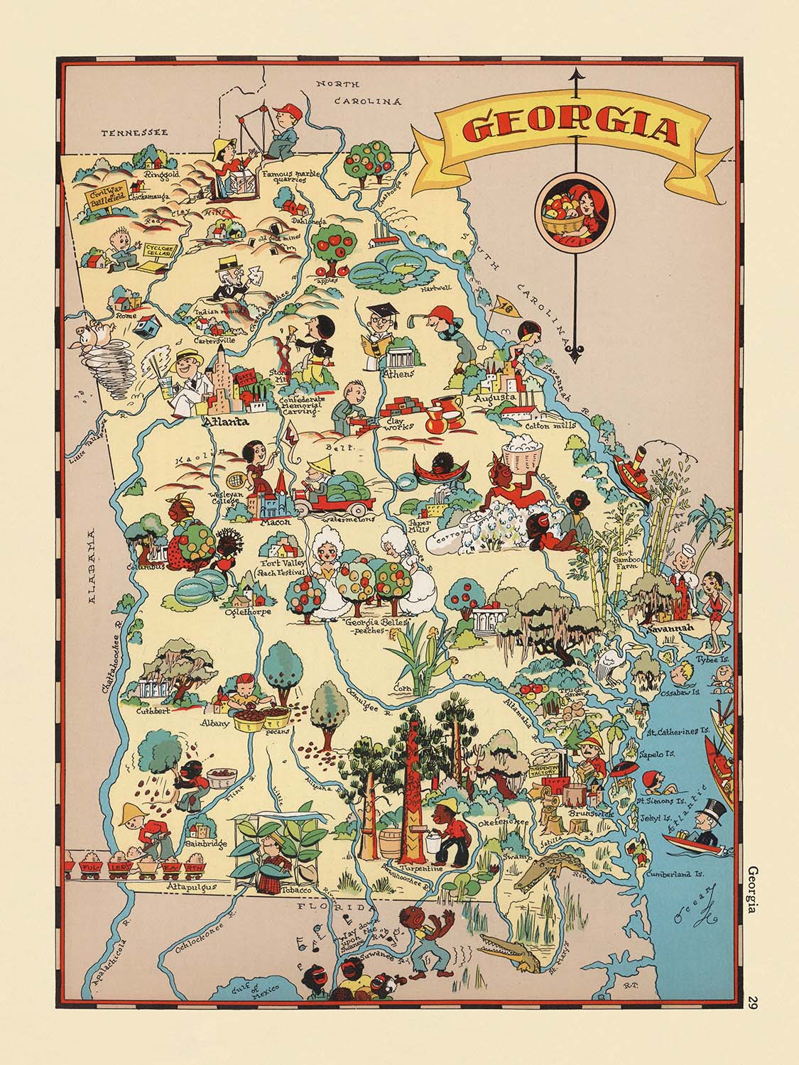
Betreten Sie die lebendige Welt von Georgia in den 1930er Jahren mit der exquisit illustrierten Karte, die einfach "Georgia" heißt und 1935 von der gefeierten Ruth Taylor White geschaffen wurde. Dieses bildliche Meisterwerk ist weit mehr als ein bloßes geografisches Dokument - es ist eine fröhliche Feier des einzigartigen Charakters des Bundesstaates, dargestellt in einem Stil, der sowohl verspielt als auch akribisch detailliert ist. Jeder Zentimeter der Karte ist lebendig mit Farbe und Energie und lädt die Betrachter ein, Georgia so zu erleben, wie es in einer Zeit voller Schwierigkeiten und Hoffnungen vorgestellt wurde. Die verspielte Kunstfertigkeit der Karte und die ansprechenden Vignetten wecken ein Gefühl der Nostalgie und machen sie zu einem fesselnden Gesprächsthema für Sammler und Kenner gleichermaßen.
Ruth Taylor White, bekannt für ihre Arbeiten im Bereich der bildlichen Karten, bringt ihren charakteristischen Stil in diese Darstellung Georgias ein. Zusammen mit ihrem Mann, Frank Taylor White, schuf sie eine Reihe von Cartoon-Atlanten, die die Sichtweise der Amerikaner auf ihre eigene Geographie neu definierten. Ihr Ansatz ist sofort erkennbar: kräftige, gesättigte Farben, lebhafte Karikaturen und ein sanfter Humor, der zur Erkundung einlädt. Jede Landkreisgrenze ist sorgfältig gezeichnet, während die Illustrationen - die alles von geschäftigen Dampfschiffen bis zu ruhigen Kiefernwäldern darstellen - das Wesen der vielfältigen Landschaften und der geschichtsträchtigen Vergangenheit des Bundesstaates einfangen.
Die Karte ist ein thematisches Gewebe, das Georgias landwirtschaftliches Erbe mit Szenen aus dem täglichen Leben und der Industrie verwebt. Baumwollfelder und Pfirsichplantagen breiten sich über das Land aus, während Bilder von Vieh und Landarbeitern die Rhythmen des Landes widerspiegeln. Dampfschiffe befahren die illustrierten Flüsse und erinnern an die wichtige Rolle der Wasserwege in der Entwicklung des Bundesstaates. Die Küste wird mit einem Schwung dargestellt, der auf maritime Traditionen und die Bedeutung von Georgias atlantischer Küste hinweist. Durch diese Bilder erzählt die Karte die Geschichte eines Staates, der von seinen natürlichen Ressourcen und dem Durchhaltevermögen seiner Menschen geprägt ist.
Was diese Karte wirklich auszeichnet, ist ihre Fähigkeit, historischen Kontext mit künstlerischem Ausdruck zu verbinden. Sie wurde während der Großen Depression geschaffen und bietet einen Einblick in den Optimismus und die Widerstandsfähigkeit der Ära, selbst während sie die Bräuche und Kostüme der Einwohner Georgias sanft karikiert. Die verspielten Szenen der Karte - Angeln, Jagen und ländliche Feste - werden von einer respektvollen Beachtung der demografischen und wirtschaftlichen Realitäten des Bundesstaates ausgeglichen. Während sie keine Nationalparks oder historischen Wahrzeichen spezifisch kennzeichnet, wecken die Illustrationen der Karte die natürliche Schönheit und den kulturellen Reichtum, die Georgia definieren.
Im Mittelpunkt der Karte stehen die prominentesten Städte und Gemeinden des Bundesstaates, die jeweils sorgfältig in der illustrierten Landschaft positioniert sind. Atlanta, Savannah, Augusta und Macon stechen als Zentren des Handels und der Kultur hervor, während kleinere Städte wie Albany, Athen und Brunswick mit gleicher Anziehungskraft dargestellt werden. Die akribische Beachtung sowohl der Geographie als auch der Fantasie der Karte sorgt dafür, dass jeder Betrachter in eine reizvolle Reise durch Georgia hineingezogen wird - ein Zeugnis von Ruth Taylor Whites bleibendem Erbe als eine der großen bildlichen Kartographen Amerikas.
Städte und Gemeinden auf dieser Karte
- Atlanta
- Augusta
- Savannah
- Macon
- Columbus
- Albany
- Athen
- Rom
- Brunswick
- Valdosta
Bemerkenswerte Merkmale & Wahrzeichen
- Landkreisgrenzen und -namen sind im gesamten Bundesstaat deutlich markiert.
- Illustrationen landwirtschaftlicher Tätigkeiten, wie Baumwollpflücken und Pfirsichernte, die Georgias landwirtschaftliches Erbe repräsentieren.
- Karikaturdarstellungen von Menschen in traditioneller südlicher Kleidung.
- Zeichnungen von Dampfschiffen und Flusslandschaften, die die Geschichte des Flusstransports in Georgia hervorheben.
- Bildliche Darstellung von Kiefernwäldern und Holzaktivitäten.
- Illustrationen von Vieh und Nutztieren, die das Landleben betonen.
- Bilder von afroamerikanischen Arbeitern, die die Demografie und den sozialen Kontext der Epoche widerspiegeln.
- Darstellung der Küstenlinie und maritimer Aktivitäten entlang der Atlantikküste.
- Karikaturhafte Darstellungen von Freizeitaktivitäten wie Angeln und Jagen.
- Künstlerische Darstellungen von Georgias natürlichen Landschaften, einschließlich Hügeln und Wäldern.
Historischer und gestalterischer Kontext
- Ursprüngliche Kartenmacherin: Ruth Taylor White, bekannt für ihre bildlichen Karten in den 1930er Jahren.
- Erstellungsdatum: 1935.
- Teil einer Karikaturen-Atlas-Serie, die die Vereinigten Staaten darstellt und für ihren charakteristischen bildlichen und thematischen Stil bekannt ist.
- Enthält lebendige, farbenfrohe und verspielte Illustrationen mit cartoonhaften Darstellungen von Menschen, Aktivitäten und Wahrzeichen.
- Gestaltet, um sowohl unterhaltsam als auch informativ zu sein und den Geist und Charme Georgias durch spielerische Visualisierungen einzufangen.
- Während der Großen Depression erstellt, spiegelt die Karte sowohl den Optimismus als auch die Populärkultur der Zeit wider.
- Bemerkenswert für ihre Mischung aus Geografie und Kunst, was sie sowohl zu einem Sammlerstück als auch zu einem Bildungsstück macht.
Bitte überprüfen Sie die Bilder, um sicherzustellen, dass eine bestimmte Stadt oder ein bestimmter Ort auf dieser Karte gezeigt wird. Sie können auch Kontakt aufnehmen und uns bitten, die Karte für Sie zu überprüfen.
Diese Karte sieht in jeder Größe großartig aus, aber ich empfehle immer, eine größere Größe zu wählen, wenn Sie Platz haben. So können Sie alle Details leicht erkennen.
Diese Karte sieht bei Größen bis zu 50in (125cm) erstaunlich aus. Wenn Sie nach einer größeren Karte suchen, bitte nehmen Sie Kontakt auf.
Das Modell in den Angebotsbildern hält die 18x24in (45x60cm) Version dieser Karte.
Das fünfte Angebotsbild zeigt ein Beispiel für meinen Personalisierungsservice für Karten.
Wenn Sie nach etwas etwas anderem suchen, schauen Sie sich meine Sammlung der besten alten Karten an, um zu sehen, ob etwas anderes Ihr Interesse weckt.
Bitte kontaktieren Sie mich, um zu prüfen, ob ein bestimmter Standort, ein Wahrzeichen oder ein Merkmal auf dieser Karte angezeigt wird.
Dies wäre ein wunderbares Geschenk zum Geburtstag, zu Weihnachten, zum Vatertag, zum Abschied von der Arbeit, zum Jubiläum oder zur Einweihung für jemanden aus den Gebieten, die von dieser Karte abgedeckt werden.
Diese Karte ist als Giclée-Druck auf säurefreiem, archivierbarem mattem Papier erhältlich, oder Sie können sie gerahmt kaufen. Der Rahmen ist ein schöner, einfacher schwarzer Rahmen, der zu den meisten Ästhetiken passt. Bitte kontaktieren Sie mich, wenn Sie eine andere Rahmenfarbe oder -material wünschen. Meine Rahmen sind mit superklarem Museumsglas (Plexiglas/Acryllit) verglast, das deutlich weniger reflektierend ist als Glas, sicherer ist und immer in perfektem Zustand ankommt.
This map is also available as a float framed canvas, sometimes known as a shadow gap framed canvas or canvas floater. The map is printed on artist's cotton canvas and then stretched over a handmade box frame. We then "float" the canvas inside a wooden frame, which is available in a range of colours (black, dark brown, oak, antique gold and white). This is a wonderful way to present a map without glazing in front. See some examples of float framed canvas maps and explore the differences between my different finishes.
For something truly unique, this map is also available in "Unique 3D", our trademarked process that dramatically transforms the map so that it has a wonderful sense of depth. We combine the original map with detailed topography and elevation data, so that mountains and the terrain really "pop". For more info and examples of 3D maps, check my Unique 3D page.
Many of our maps and art prints are chosen as thoughtful gifts for homes, offices, studies and meaningful places.
Choose a framed option for the easiest ready-to-hang gift, or choose an unframed print if the recipient may prefer to select their own frame.
We make orders locally in 23 countries around the world, so gifts can often be produced close to the recipient. This helps them arrive faster, travel more safely, and avoid customs or import duty surprises.
- We can deliver directly to the recipient
- Framed pieces arrive ready to hang
- Unframed prints are carefully packed in a strong protective tube
- Almost every order is made locally, for faster, safer gifting
- 90-day returns give the recipient time to decide
If you are not sure what to choose, please contact us. We can help you pick the right map, size, finish or delivery option.
Für die meisten Bestellungen beträgt die Lieferzeit etwa 3 Werktage. Personalisierte und maßgeschneiderte Produkte benötigen länger, da ich die Personalisierung durchführen und sie Ihnen zur Genehmigung zusenden muss, was normalerweise 1 oder 2 Tage dauert.
Bitte beachten Sie, dass sehr große gerahmte Bestellungen in der Regel länger für die Herstellung und Lieferung benötigen.
Wenn Sie möchten, dass Ihre Bestellung bis zu einem bestimmten Datum ankommt, bitte kontaktieren Sie mich, bevor Sie bestellen, damit wir den besten Weg finden können, um sicherzustellen, dass Sie Ihre Bestellung rechtzeitig erhalten.
Ich drucke und rahme Karten und Kunstwerke in 23 Ländern weltweit. Das bedeutet, dass Ihre Bestellung lokal gefertigt wird, was die Lieferzeit verkürzt und sicherstellt, dass sie während der Lieferung nicht beschädigt wird. Sie zahlen nie Zoll oder Einfuhrgebühren, und wir stoßen weniger CO2 in die Luft aus.
Alle meine Karten und Kunstdrucke sind gut verpackt und werden in einem robusten Rohr versendet, wenn sie ungerahmt sind, oder von Schaum umgeben, wenn sie gerahmt sind.
Ich versuche, alle Bestellungen innerhalb von 1 oder 2 Tagen nach Erhalt Ihrer Bestellung zu versenden, obwohl einige Produkte (wie Gesichtsmasken, Tassen und Tragetaschen) länger zur Herstellung benötigen können.
Wenn Sie Express-Lieferung an der Kasse auswählen, priorisieren wir Ihre Bestellung und versenden sie per 1-Tages-Kurier (Fedex, DHL, UPS, Parcelforce).
Nächster Tag Lieferung ist auch in einigen Ländern verfügbar (USA, UK, Singapur, VAE), aber bitte versuchen Sie, früh am Tag zu bestellen, damit wir es rechtzeitig versenden können.
Lesen Sie meinen vollständigen Leitfaden zur Lieferung und lokalen Produktion
Mein Standardrahmen ist ein Galerie-Stil-Rahmen aus schwarzem Eschenholz. Er ist einfach und sieht ziemlich modern aus. Mein Standardrahmen ist etwa 20 mm (0,8 Zoll) breit.
Ich verwende super-klares Acryl (Plexiglas/Acrylt) für das Glas des Rahmens. Es ist leichter und sicherer als Glas – und es sieht besser aus, da die Reflexion geringer ist.
Sechs Standardrahmenfarben sind kostenlos erhältlich (schwarz, dunkelbraun, dunkelgrau, Eiche, weiß und antikgold).
Die meisten Karten, Kunstwerke und Illustrationen sind auch als gerahmte Leinwand erhältlich. Wir verwenden matte (nicht glänzende) Baumwollleinwand, spannen sie über einen nachhaltig beschafften Buchenrahmen und 'schweben' dann das Stück innerhalb eines Holzrahmens. Das Endergebnis ist ziemlich schön, und es gibt keine Verglasung, die im Weg ist.
Alle Rahmen werden "bereit zum Aufhängen" geliefert, entweder mit einer Schnur oder Halterungen auf der Rückseite. Sehr große Rahmen haben schwere Aufhängeplatten und/oder eine Montageschiene. Wenn Sie Fragen haben, können Sie bitte Kontakt aufnehmen.
Sehen Sie sich einige Beispiele meiner gerahmten Karten und gerahmten Leinwandkarten an.
Alternativ kann ich auch alte Karten und Kunstwerke auf Leinwand, Schaumstoffplatten, Baumwollrag und andere Materialien liefern.
Wenn Sie Ihre Karte oder Ihr Kunstwerk selbst rahmen möchten, lesen Sie bitte zuerst meinen Größenleitfaden.
Meine Karten sind äußerst hochwertige Reproduktionen von Originalkarten.
Ich beziehe originale, seltene Karten aus Bibliotheken, Auktionshäusern und Privatsammlungen auf der ganzen Welt, restauriere sie in meiner Londoner Werkstatt und erstelle dann mit speziellen Giclée-Tinten und -Druckern wunderschöne Karten, die sogar noch besser aussehen als das Original.
Meine Karten werden auf säurefreiem, mattem Archivpapier (nicht glänzend) gedruckt, das sich sehr hochwertig anfühlt und fast wie Karton aussieht. Technisch gesehen beträgt das Papiergewicht/die Papierdicke 10mil/200g/m². Es eignet sich perfekt zum Einrahmen.
Ich drucke mit UV-lichtbeständigen Ultrachrome-Giclée-Pigmenttinten von Epson – einige der besten Tinten, die Sie finden können.
Ich kann auch machen Karten auf Leinwand, Baumwolllappen und andere exotische Materialien.
Erfahren Sie mehr über The Unique Maps Co.
Kartenpersonalisierung
Wenn Sie nach dem perfekten Geschenk zum Jahrestag oder zur Einweihung suchen, kann ich Ihre Karte personalisieren, um sie wirklich einzigartig zu machen. Ich kann beispielsweise eine kurze Nachricht hinzufügen, einen wichtigen Ort hervorheben oder das Wappen Ihrer Familie hinzufügen.
Die Möglichkeiten sind nahezu unbegrenzt. Bitte sehen Sie sich meine Kartenpersonalisierungsseite für einige wunderbare Beispiele dessen, was möglich ist.
Um eine personalisierte Karte zu bestellen, wählen Sie „Personalisieren Sie Ihre Karte“, bevor Sie sie in den Warenkorb legen.
In Kontakt kommen wenn Sie nach komplexeren Anpassungen und Personalisierungen suchen.
Kartenalterung
Im Laufe der Jahre wurde ich von Kunden hunderte Male gefragt, ob sie eine Karte kaufen könnten, die noch älter.
Nun, jetzt können Sie das, indem Sie „Alter“ auswählen, bevor Sie eine Karte in Ihren Warenkorb legen.
Alle Produktfotos, die Sie auf dieser Seite sehen, zeigen die Karte in ihrer Originalform. So sieht die Karte heute aus.
Wenn Sie „Gealtert“ auswählen, werde ich Ihre Karte von Hand altern lassen. Dazu verwende ich ein spezielles und einzigartiges Verfahren, das ich durch jahrelanges Studium alter Karten und Gespräche mit Forschern zum Verständnis der Chemie alternder Papiere entwickelt habe, und natürlich ... viel Übung!
Wenn Sie sich nicht sicher sind, bleiben Sie bei der Originalfarbe der Karte. Wenn Sie etwas Dunkleres und älter Wenn Sie auf der Suche sind, entscheiden Sie sich für „Aged“.
Sehen Sie einige erstaunliche Beispiele für gealterte Karten.
Wenn Sie aus irgendeinem Grund mit Ihrer Bestellung nicht zufrieden sind, kontaktieren Sie mich für eine unkomplizierte Rückerstattung. Bitte sehen Sie sich unsere Rückgabe- und Rückerstattungsrichtlinien für weitere Informationen an.
Ich bin sehr zuversichtlich, dass Ihnen Ihre restaurierte Karte oder Kunstdruck gefallen wird. Ich mache das seit 1984. Ich bin ein 5-Sterne Etsy-Verkäufer. Ich habe Zehntausende von Karten und Kunstdrucken verkauft und habe über 5.000 echte 5-Sterne-Bewertungen.
Ich verwende einen einzigartigen Prozess, um Karten und Kunstwerke zu restaurieren, der extrem zeitaufwendig und arbeitsintensiv ist. Die Suche nach den Originalkarten und Illustrationen kann Monate dauern. Ich benutze modernste und unglaublich teure Technologie, um sie zu scannen und wiederherzustellen. Daher garantiere ich, dass meine Karten und Kunstdrucke eine Klasse für sich sind - deshalb kann ich eine unkomplizierte Rückerstattung anbieten.
Fast alle meine Karten und Kunstdrucke sehen in großen Größen (200 cm, 6,5 Fuß+) erstaunlich aus und ich kann sie Ihnen auch gerahmt und über einen speziellen Übergrößen-Kurier liefern. Kontaktieren Sie mich, um Ihre speziellen Bedürfnisse zu besprechen.
Or try searching for something!


