

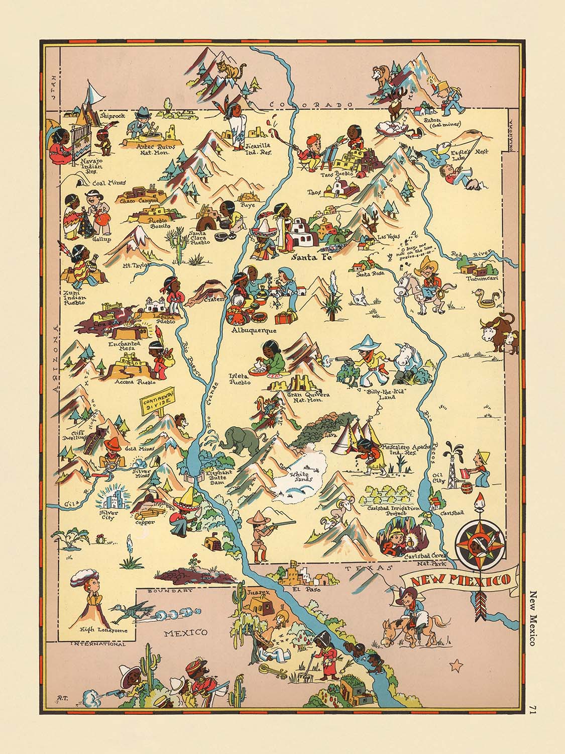


Carte picturale du Nouveau-Mexique par Ruth Taylor White, 1935: Albuquerque, Santa Fe, Rio Grande, Grottes de Carlsbad, Forêt nationale de Gila
L’offre du collectionneur
Choisissez deux œuvres éligibles et bénéficiez de 20 % de réduction sur les deux. Choisissez-en trois et celle au prix le plus bas est offerte, pour une économie maximale de 33 %.
Associez librement des cartes standard éligibles et des tirages d’art. Aucun code n’est requis ; l’offre est appliquée automatiquement lors du paiement.
Les configurations standard réalisées sur commande sont incluses. Les formats sur mesure, les créations personnalisées et les œuvres commissionnées sont exclus.
Besoin d’une livraison à différentes adresses ? Contactez-nous avant de commander.L’offre du collectionneur
Choisissez deux œuvres éligibles et bénéficiez de 20 % de réduction sur les deux. Choisissez-en trois et celle au prix le plus bas est offerte, pour une économie maximale de 33 %.
Associez librement des cartes standard éligibles et des tirages d’art. Aucun code n’est requis ; l’offre est appliquée automatiquement lors du paiement.
Les configurations standard réalisées sur commande sont incluses. Les formats sur mesure, les créations personnalisées et les œuvres commissionnées sont exclus.
Besoin d’une livraison à différentes adresses ? Contactez-nous avant de commander. Conçu à Londres Fabriqué en Australia
Conçu à Londres • Fabriqué en Australia
Conçu à Londres Fabriqué en Australia
Conçu à Londres • Fabriqué en Australia

Restaurée à partir de la carte originale de 1935 et imprimée en qualité musée. Lire l’histoire de cette carte
Choose your size
Choose your finish


(Plus d’infos)
Message cadeau & finition personnalisée

Si vous souhaitez ajouter un message cadeau, ou une finition (puzzle, panneau en aluminium, etc.) qui n'est pas disponible ici, veuillez le demander dans la "note de commande" lors de votre passage à la caisse.
Chaque commande est fabriquée sur mesure, donc si vous avez besoin d'ajuster légèrement la taille, ou d'imprimer sur un matériau inhabituel, faites-le nous savoir. Nous avons réalisé des milliers de commandes personnalisées au fil des ans, donc il n'y a (presque) rien que nous ne puissions gérer.
Vous pouvez également nous contacter avant de passer votre commande, si vous le souhaitez !

- Fabriqué localement. Livraison sûre
- Sans droits ni frais cachés
- Besoin d’aide ? Appelez-nous ou message WhatsApp
Own a piece of history
8,000+ five-star reviews


Entrez dans la tapisserie vibrante du sud-ouest américain avec « Nouveau Mexique », une carte picturale captivante réalisée en 1935 par la...
Continuer la lectureEntrez dans la tapisserie vibrante du sud-ouest américain avec « Nouveau Mexique », une carte picturale captivante réalisée en 1935 par la célèbre cartographe Ruth Taylor White. Cette carte enchanteuse se distingue dans la série d'atlas fantaisistes de White, où chaque État prend vie à travers un kaléidoscope de couleurs, d'humour et d'observation aiguë. Le titre original, « Nouveau Mexique », reflète à la fois l'accent géographique et l'esprit créatif de l'époque, invitant les spectateurs à explorer la Terre de l'Enchantement telle qu'elle était perçue au début du XXe siècle. L'approche de White transforme la cartographie traditionnelle en un récit visuel engageant, mêlant art et précision géographique.
Le legs de Ruth Taylor White en tant que cartographe est indissociable de son style unique : ses cartes sont instantanément reconnaissables par leurs illustrations ludiques et de type cartoon, ainsi que par une attention méticuleuse au caractère régional. Le travail de White transcende la simple documentation, offrant un instantané vivant de la vie culturelle et sociale. Dans « Nouveau Mexique », elle tisse habilement les diverses influences de l'État, des pueblos amérindiens et des missions espagnoles à la vie rude des cow-boys et des mineurs. Ses illustrations capturent non seulement le paysage, mais aussi l'essence de ses habitants, de ses industries et de ses traditions, faisant de chaque carte un voyage délicieux à travers le temps et l'espace.
Le design de cette carte est une masterclass en cartographie picturale. Les limites des comtés sont élégamment délimitées, tandis que le célèbre Rio Grande serpente à travers le cœur de l'État, ancrant la composition. Les montagnes Sangre de Cristo s'élèvent majestueusement au nord, et la forêt nationale de Gila s'étend à travers le sud-ouest, chacune rendue avec une touche artistique. Les représentations fantaisistes de White de la faune locale, des scènes agricoles et de la flore désertique—comme les cactus et les champs de coton—ajoutent des couches de texture et de narration, invitant le spectateur à s'attarder sur chaque détail. La palette vibrante de la carte et ses illustrations dynamiques évoquent les paysages baignés de soleil et le patrimoine multiculturel qui définissent le Nouveau Mexique.
Un point culminant de ce chef-d'œuvre pictural est sa célébration des monuments les plus notables et des merveilles naturelles du Nouveau Mexique. Les Grottes de Carlsbad, une merveille souterraine, sont mises en avant, tout comme les sources chaudes qui parsèment le paysage du sud. La carte rend hommage au fleuve Pecos et aux régions Zuni et Navajo, avec des hommages respectueux à la culture et à l'art autochtones. L'activité minière, l'élevage de bétail et les activités agricoles sont représentés avec précision et charme, reflétant le pouls économique de l'État durant les années 1930. À travers ces vignettes, la carte de White devient un document vivant des espoirs, des défis et des réalisations de l'époque.
Aucune exploration du « Nouveau Mexique » ne serait complète sans noter la constellation de villes et de villages qui ponctuent la carte, d'Albuquerque et Santa Fe à des établissements plus petits comme Socorro et Silver City. Chacun est illustré avec soin, reflétant son caractère unique et son rôle dans l'histoire de l'État. Le style ludique de la carte cache sa richesse d'informations, offrant une fenêtre sur le tissu social et économique du Nouveau Mexique tel qu'il était il y a près d'un siècle. Pour les collectionneurs et les connaisseurs de la cartographie historique, « Nouveau Mexique » de Ruth Taylor White est plus qu'une carte—c'est une invitation à découvrir, se souvenir et célébrer une terre riche en histoires.
Villes et villages sur cette carte
- Albuquerque
- Las Cruces
- Santa Fe
- Rio Rancho
- Roswell
- Farmington
- Clovis
- Hobbs
- Alamogordo
- Carlsbad
- Gallup
- Deming
- Los Alamos
- Silver City
- Raton
- Tucumcari
- Portales
- Socorro
- Truth or Consequences
- Clayton
Caractéristiques et monuments notables
- Les limites des comtés au Nouveau-Mexique sont clairement délimitées.
- Le fleuve Rio Grande est illustré de manière proéminente, courant du nord au sud à travers l'état.
- Les Cavernes de Carlsbad sont représentées et étiquetées, soulignant leur importance en tant que monument naturel.
- La forêt nationale de Gila est illustrée dans la partie sud-ouest de l'état.
- Le fleuve Pecos est montré coulant à travers l'est du Nouveau-Mexique.
- Les montagnes Sangre de Cristo sont représentées dans la partie nord de l'état.
- Des illustrations de pueblos amérindiens et de scènes culturelles sont présentes.
- Des images de cowboys et d'élevage de bétail sont montrées, reflétant l'héritage rancher de l'état.
- Des représentations d'activités minières, comme des mineurs et de l'équipement minier, sont visibles.
- Des illustrations d'activités agricoles, y compris la culture de piments et de coton, sont présentes.
- Les régions Zuni et Navajo sont illustrées avec des références à la culture amérindienne.
- La carte inclut des illustrations fantaisistes de la faune locale, comme des cerfs et des moutons.
- Des sources chaudes sont représentées dans la partie sud de l'état.
- La carte présente des représentations artistiques des influences culturelles espagnoles et mexicaines.
- Le paysage désertique et les cactus sont illustrés dans les régions sud et ouest.
Contexte historique et de conception
- Nom de la carte : "Nouveau-Mexique"
- Date de création : 1935
- Cartographe : Ruth Taylor White
- Éditeur/contexte : Partie d'une série d'atlas pictural créée par Ruth Taylor White et Frank J. Taylor, connus pour leurs représentations fantaisistes et de style cartoon des états américains.
- Type de carte : Carte thématique et picturale des comtés ou des états
- Conception/style : La carte présente des illustrations vibrantes et colorées avec un style ludique et cartoon, typique des cartes picturales de cette époque.
- Focus thématique : La carte met en avant des scènes stéréotypées et des éléments culturels associés au Nouveau-Mexique dans les années 1930, y compris des représentations des industries locales, des groupes ethniques et des activités régionales.
- Approche artistique : Les illustrations sont fantaisistes et exagérées, destinées à divertir autant qu'à informer, reflétant les récits sociaux et culturels de l'époque.
- Importance historique : La carte offre un aperçu de la façon dont le Nouveau-Mexique était perçu et représenté dans la culture populaire des années 1930, y compris les stéréotypes communs et les caractéristiques notables de l'état.
- Contexte notable sur le cartographe : Ruth Taylor White était connue pour ses cartes picturales distinctives, qui combinaient humour, art et informations géographiques, et ont contribué à la popularisation de la cartographie picturale au début du 20ème siècle.
Veuillez vérifier les images pour vous assurer qu'une ville ou un lieu spécifique est montré sur cette carte. Vous pouvez également nous contacter et nous demander de vérifier la carte pour vous.
Cette carte a l'air géniale à toutes les tailles, mais je recommande toujours d'opter pour une taille plus grande si vous avez de l'espace. De cette façon, vous pouvez facilement distinguer tous les détails.
Cette carte a l'air incroyable à des tailles allant jusqu'à 50 pouces (125 cm). Si vous recherchez une carte plus grande, veuillez nous contacter.
Le modèle sur les images de l'annonce tient la version de cette carte de 18x24 pouces (45x60 cm).
La cinquième image de l'annonce montre un exemple de mon service de personnalisation de cartes.
Si vous recherchez quelque chose de légèrement différent, consultez ma collection des meilleures anciennes cartes pour voir si quelque chose d'autre attire votre attention.
Veuillez me contacter pour vérifier si un certain emplacement, monument ou caractéristique est représenté sur cette carte.
Cela ferait un merveilleux cadeau d'anniversaire, de Noël, pour la fête des pères, un départ au travail, un anniversaire de mariage ou une pendaison de crémaillère pour quelqu'un des zones couvertes par cette carte.
Cette carte est disponible en tant qu'impression giclée sur papier mat d'archivage sans acide, ou vous pouvez l'acheter encadrée. Le cadre est un joli cadre noir simple qui convient à la plupart des esthétiques. Veuillez me contacter si vous souhaitez une couleur ou un matériau de cadre différent. Mes cadres sont vitrifiés avec un acrylique de musée super clair (perspex/acrylite), qui est significativement moins réfléchissant que le verre, plus sûr, et arrivera toujours en parfait état.
This map is also available as a float framed canvas, sometimes known as a shadow gap framed canvas or canvas floater. The map is printed on artist's cotton canvas and then stretched over a handmade box frame. We then "float" the canvas inside a wooden frame, which is available in a range of colours (black, dark brown, oak, antique gold and white). This is a wonderful way to present a map without glazing in front. See some examples of float framed canvas maps and explore the differences between my different finishes.
For something truly unique, this map is also available in "Unique 3D", our trademarked process that dramatically transforms the map so that it has a wonderful sense of depth. We combine the original map with detailed topography and elevation data, so that mountains and the terrain really "pop". For more info and examples of 3D maps, check my Unique 3D page.
Entrez dans la tapisserie vibrante du sud-ouest américain avec « Nouveau Mexique », une carte picturale captivante réalisée en 1935 par la célèbre cartographe Ruth Taylor White. Cette carte enchanteuse se distingue dans la série d'atlas fantaisistes de White, où chaque État prend vie à travers un kaléidoscope de couleurs, d'humour et d'observation aiguë. Le titre original, « Nouveau Mexique », reflète à la fois l'accent géographique et l'esprit créatif de l'époque, invitant les spectateurs à explorer la Terre de l'Enchantement telle qu'elle était perçue au début du XXe siècle. L'approche de White transforme la cartographie traditionnelle en un récit visuel engageant, mêlant art et précision géographique.
Le legs de Ruth Taylor White en tant que cartographe est indissociable de son style unique : ses cartes sont instantanément reconnaissables par leurs illustrations ludiques et de type cartoon, ainsi que par une attention méticuleuse au caractère régional. Le travail de White transcende la simple documentation, offrant un instantané vivant de la vie culturelle et sociale. Dans « Nouveau Mexique », elle tisse habilement les diverses influences de l'État, des pueblos amérindiens et des missions espagnoles à la vie rude des cow-boys et des mineurs. Ses illustrations capturent non seulement le paysage, mais aussi l'essence de ses habitants, de ses industries et de ses traditions, faisant de chaque carte un voyage délicieux à travers le temps et l'espace.
Le design de cette carte est une masterclass en cartographie picturale. Les limites des comtés sont élégamment délimitées, tandis que le célèbre Rio Grande serpente à travers le cœur de l'État, ancrant la composition. Les montagnes Sangre de Cristo s'élèvent majestueusement au nord, et la forêt nationale de Gila s'étend à travers le sud-ouest, chacune rendue avec une touche artistique. Les représentations fantaisistes de White de la faune locale, des scènes agricoles et de la flore désertique—comme les cactus et les champs de coton—ajoutent des couches de texture et de narration, invitant le spectateur à s'attarder sur chaque détail. La palette vibrante de la carte et ses illustrations dynamiques évoquent les paysages baignés de soleil et le patrimoine multiculturel qui définissent le Nouveau Mexique.
Un point culminant de ce chef-d'œuvre pictural est sa célébration des monuments les plus notables et des merveilles naturelles du Nouveau Mexique. Les Grottes de Carlsbad, une merveille souterraine, sont mises en avant, tout comme les sources chaudes qui parsèment le paysage du sud. La carte rend hommage au fleuve Pecos et aux régions Zuni et Navajo, avec des hommages respectueux à la culture et à l'art autochtones. L'activité minière, l'élevage de bétail et les activités agricoles sont représentés avec précision et charme, reflétant le pouls économique de l'État durant les années 1930. À travers ces vignettes, la carte de White devient un document vivant des espoirs, des défis et des réalisations de l'époque.
Aucune exploration du « Nouveau Mexique » ne serait complète sans noter la constellation de villes et de villages qui ponctuent la carte, d'Albuquerque et Santa Fe à des établissements plus petits comme Socorro et Silver City. Chacun est illustré avec soin, reflétant son caractère unique et son rôle dans l'histoire de l'État. Le style ludique de la carte cache sa richesse d'informations, offrant une fenêtre sur le tissu social et économique du Nouveau Mexique tel qu'il était il y a près d'un siècle. Pour les collectionneurs et les connaisseurs de la cartographie historique, « Nouveau Mexique » de Ruth Taylor White est plus qu'une carte—c'est une invitation à découvrir, se souvenir et célébrer une terre riche en histoires.
Villes et villages sur cette carte
- Albuquerque
- Las Cruces
- Santa Fe
- Rio Rancho
- Roswell
- Farmington
- Clovis
- Hobbs
- Alamogordo
- Carlsbad
- Gallup
- Deming
- Los Alamos
- Silver City
- Raton
- Tucumcari
- Portales
- Socorro
- Truth or Consequences
- Clayton
Caractéristiques et monuments notables
- Les limites des comtés au Nouveau-Mexique sont clairement délimitées.
- Le fleuve Rio Grande est illustré de manière proéminente, courant du nord au sud à travers l'état.
- Les Cavernes de Carlsbad sont représentées et étiquetées, soulignant leur importance en tant que monument naturel.
- La forêt nationale de Gila est illustrée dans la partie sud-ouest de l'état.
- Le fleuve Pecos est montré coulant à travers l'est du Nouveau-Mexique.
- Les montagnes Sangre de Cristo sont représentées dans la partie nord de l'état.
- Des illustrations de pueblos amérindiens et de scènes culturelles sont présentes.
- Des images de cowboys et d'élevage de bétail sont montrées, reflétant l'héritage rancher de l'état.
- Des représentations d'activités minières, comme des mineurs et de l'équipement minier, sont visibles.
- Des illustrations d'activités agricoles, y compris la culture de piments et de coton, sont présentes.
- Les régions Zuni et Navajo sont illustrées avec des références à la culture amérindienne.
- La carte inclut des illustrations fantaisistes de la faune locale, comme des cerfs et des moutons.
- Des sources chaudes sont représentées dans la partie sud de l'état.
- La carte présente des représentations artistiques des influences culturelles espagnoles et mexicaines.
- Le paysage désertique et les cactus sont illustrés dans les régions sud et ouest.
Contexte historique et de conception
- Nom de la carte : "Nouveau-Mexique"
- Date de création : 1935
- Cartographe : Ruth Taylor White
- Éditeur/contexte : Partie d'une série d'atlas pictural créée par Ruth Taylor White et Frank J. Taylor, connus pour leurs représentations fantaisistes et de style cartoon des états américains.
- Type de carte : Carte thématique et picturale des comtés ou des états
- Conception/style : La carte présente des illustrations vibrantes et colorées avec un style ludique et cartoon, typique des cartes picturales de cette époque.
- Focus thématique : La carte met en avant des scènes stéréotypées et des éléments culturels associés au Nouveau-Mexique dans les années 1930, y compris des représentations des industries locales, des groupes ethniques et des activités régionales.
- Approche artistique : Les illustrations sont fantaisistes et exagérées, destinées à divertir autant qu'à informer, reflétant les récits sociaux et culturels de l'époque.
- Importance historique : La carte offre un aperçu de la façon dont le Nouveau-Mexique était perçu et représenté dans la culture populaire des années 1930, y compris les stéréotypes communs et les caractéristiques notables de l'état.
- Contexte notable sur le cartographe : Ruth Taylor White était connue pour ses cartes picturales distinctives, qui combinaient humour, art et informations géographiques, et ont contribué à la popularisation de la cartographie picturale au début du 20ème siècle.
Veuillez vérifier les images pour vous assurer qu'une ville ou un lieu spécifique est montré sur cette carte. Vous pouvez également nous contacter et nous demander de vérifier la carte pour vous.
Cette carte a l'air géniale à toutes les tailles, mais je recommande toujours d'opter pour une taille plus grande si vous avez de l'espace. De cette façon, vous pouvez facilement distinguer tous les détails.
Cette carte a l'air incroyable à des tailles allant jusqu'à 50 pouces (125 cm). Si vous recherchez une carte plus grande, veuillez nous contacter.
Le modèle sur les images de l'annonce tient la version de cette carte de 18x24 pouces (45x60 cm).
La cinquième image de l'annonce montre un exemple de mon service de personnalisation de cartes.
Si vous recherchez quelque chose de légèrement différent, consultez ma collection des meilleures anciennes cartes pour voir si quelque chose d'autre attire votre attention.
Veuillez me contacter pour vérifier si un certain emplacement, monument ou caractéristique est représenté sur cette carte.
Cela ferait un merveilleux cadeau d'anniversaire, de Noël, pour la fête des pères, un départ au travail, un anniversaire de mariage ou une pendaison de crémaillère pour quelqu'un des zones couvertes par cette carte.
Cette carte est disponible en tant qu'impression giclée sur papier mat d'archivage sans acide, ou vous pouvez l'acheter encadrée. Le cadre est un joli cadre noir simple qui convient à la plupart des esthétiques. Veuillez me contacter si vous souhaitez une couleur ou un matériau de cadre différent. Mes cadres sont vitrifiés avec un acrylique de musée super clair (perspex/acrylite), qui est significativement moins réfléchissant que le verre, plus sûr, et arrivera toujours en parfait état.
This map is also available as a float framed canvas, sometimes known as a shadow gap framed canvas or canvas floater. The map is printed on artist's cotton canvas and then stretched over a handmade box frame. We then "float" the canvas inside a wooden frame, which is available in a range of colours (black, dark brown, oak, antique gold and white). This is a wonderful way to present a map without glazing in front. See some examples of float framed canvas maps and explore the differences between my different finishes.
For something truly unique, this map is also available in "Unique 3D", our trademarked process that dramatically transforms the map so that it has a wonderful sense of depth. We combine the original map with detailed topography and elevation data, so that mountains and the terrain really "pop". For more info and examples of 3D maps, check my Unique 3D page.
Many of our maps and art prints are chosen as thoughtful gifts for homes, offices, studies and meaningful places.
Choose a framed option for the easiest ready-to-hang gift, or choose an unframed print if the recipient may prefer to select their own frame.
We make orders locally in 23 countries around the world, so gifts can often be produced close to the recipient. This helps them arrive faster, travel more safely, and avoid customs or import duty surprises.
- We can deliver directly to the recipient
- Framed pieces arrive ready to hang
- Unframed prints are carefully packed in a strong protective tube
- Almost every order is made locally, for faster, safer gifting
- 90-day returns give the recipient time to decide
If you are not sure what to choose, please contact us. We can help you pick the right map, size, finish or delivery option.
Pour la plupart des commandes, le délai de livraison est d'environ 3 jours ouvrables. Les produits personnalisés et sur mesure prennent plus de temps, car je dois faire la personnalisation et vous l'envoyer pour approbation, ce qui prend généralement 1 ou 2 jours.
Veuillez noter que les grandes commandes encadrées prennent généralement plus de temps à réaliser et à livrer.
Si vous avez besoin que votre commande arrive à une date précise, veuillez me contacter avant de passer votre commande afin que nous puissions trouver le meilleur moyen de nous assurer que vous receviez votre commande à temps.
J'imprime et encadre des cartes et des œuvres d'art dans 23 pays à travers le monde. Cela signifie que votre commande sera réalisée localement, ce qui réduit le temps de livraison et garantit qu'elle ne sera pas endommagée pendant le transport. Vous ne paierez jamais de droits de douane ou d'importation, et nous mettrons moins de CO2 dans l'air.
Toutes mes cartes et impressions artistiques sont bien emballées et envoyées dans un tube robuste si non encadrées, ou entourées de mousse si encadrées.
J'essaie d'envoyer toutes les commandes dans les 1 ou 2 jours suivant la réception de votre commande, bien que certains produits (comme les masques, les mugs et les sacs fourre-tout) puissent prendre plus de temps à réaliser.
Si vous choisissez Livraison Express lors du paiement, nous donnerons la priorité à votre commande et l'enverrons par un service de messagerie de 1 jour (Fedex, DHL, UPS, Parcelforce).
La livraison le lendemain est également disponible dans certains pays (États-Unis, Royaume-Uni, Singapour, Émirats Arabes Unis), mais veuillez essayer de commander tôt dans la journée afin que nous puissions l'envoyer à temps.
Lisez mon guide complet sur la livraison et la production locale
Mon cadre standard est un cadre en bois dur noir de style galerie. Il est simple et a un aspect assez moderne. Mon cadre standard mesure environ 20 mm (0,8 po) de large.
J'utilise de l'acrylique super clair (perspex/acrylite) pour le verre du cadre. C'est plus léger et plus sûr que le verre - et cela a meilleur aspect, car la réflexivité est plus faible.
Six couleurs de cadre standard sont disponibles gratuitement (noir, marron foncé, gris foncé, chêne, blanc et or antique). Des encadrements et montages/matelassages personnalisés sont disponibles si vous recherchez autre chose.
La plupart des cartes, œuvres d'art et illustrations sont également disponibles sous forme de toile encadrée. Nous utilisons une toile en coton mate (non brillante), que nous tendons sur un cadre en bois de boîte provenant de sources durables, puis nous 'flottions' la pièce à l'intérieur d'un cadre en bois. Le résultat final est assez beau, et il n'y a pas de vitrage qui gêne.
Tous les cadres sont fournis "prêts à accrocher", avec soit une corde, soit des supports à l'arrière. Les très grands cadres auront des plaques de suspension lourdes et/ou une latte de montage. Si vous avez des questions, veuillez nous contacter.
Voir quelques exemples de mes cartes encadrées et de cartes en toile encadrées.
Alternativement, je peux également fournir de vieilles cartes et œuvres d'art sur toile, sur panneau en mousse, en coton et d'autres matériaux.
Si vous souhaitez encadrer votre carte ou œuvre d'art vous-même, veuillez lire d'abord mon guide des tailles.
Mes cartes sont des reproductions de cartes originales de très haute qualité.
Je recherche des cartes originales et rares auprès de bibliothèques, de maisons de ventes aux enchères et de collections privées du monde entier, je les restaure dans mon atelier de Londres, puis j'utilise des encres et des imprimantes giclées spécialisées pour créer de magnifiques cartes encore plus belles que l'originale.
Mes cartes sont imprimées sur du papier d’archives mat (non brillant) sans acide qui semble de très haute qualité et ressemble presque à une carte. En termes techniques, le grammage/épaisseur du papier est de 10 mil/200 g/m². C'est parfait pour l'encadrement.
J’imprime avec des encres pigmentaires Epson ultrachrome giclée UV résistantes à la décoloration – certaines des meilleures encres que vous puissiez trouver.
je peux aussi faire cartes sur toile, chiffon en coton et autres matériaux exotiques.
En savoir plus sur Unique Maps Co..
Personnalisation de la carte
Si vous recherchez le cadeau parfait pour un anniversaire ou une pendaison de crémaillère, je peux personnaliser votre carte pour la rendre vraiment unique. Par exemple, je peux ajouter un court message, mettre en évidence un lieu important ou ajouter les armoiries de votre famille.
Les options sont presque infinies. S'il vous plaît voir mon page de personnalisation de la carte pour quelques merveilleux exemples de ce qui est possible.
Pour commander une carte personnalisée, sélectionnez « personnaliser votre carte » avant de l'ajouter à votre panier.
Entrer en contact si vous recherchez des personnalisations et des personnalisations plus complexes.
Vieillissement de la carte
Au fil des ans, des clients m'ont demandé des centaines de fois s'ils pouvaient acheter une carte qui semble uniforme. plus vieux.
Eh bien, vous pouvez désormais le faire en sélectionnant Aged avant d'ajouter une carte à votre panier.
Toutes les photos de produits que vous voyez sur cette page montrent la carte dans sa forme originale. Voilà à quoi ressemble la carte aujourd'hui.
Si vous sélectionnez Vieilli, je vieillirai votre carte à la main, en utilisant un processus spécial et unique développé au cours d'années d'étude de cartes anciennes, de discussions avec des chercheurs pour comprendre la chimie du vieillissement du papier, et bien sûr... beaucoup de pratique !
Si vous n'êtes pas sûr, respectez la couleur originale de la carte. Si vous voulez quelque chose d'un peu plus sombre et plus vieux à la recherche, optez pour Aged.
Si vous n'êtes pas satisfait de votre commande pour une raison quelconque, contactez-moi pour un remboursement sans conditions. Veuillez consulter notre politique de retours et de remboursements pour plus d'informations.
Je suis très confiant que vous aimerez votre carte restaurée ou votre impression artistique. Je fais cela depuis 1984. Je suis un vendeur Etsy 5 étoiles. J'ai vendu des dizaines de milliers de cartes et d'impressions artistiques et j'ai plus de 5 000 vrais avis 5 étoiles.
J'utilise un processus unique pour restaurer des cartes et des œuvres d'art qui est extrêmement chronophage et exigeant en main-d'œuvre. Trouver les cartes et illustrations originales peut prendre des mois. J'utilise une technologie de pointe et incroyablement coûteuse pour les numériser et les restaurer. En conséquence, je garantis que mes cartes et impressions artistiques sont d'une qualité supérieure - c'est pourquoi je peux offrir un remboursement sans conditions.
Presque toutes mes cartes et impressions artistiques ont l'air incroyables en grandes tailles (200 cm, 6,5 pieds+) et je peux également les encadrer et vous les livrer, via un transporteur spécial surdimensionné. Contactez-moi pour discuter de vos besoins spécifiques.
Or try searching for something!


