


Carte picturale de la Floride par Ruth Taylor White, 1935: Everglades, Miami, Orlando, Keys, vergers d'agrumes
L’offre du collectionneur
Choisissez deux œuvres éligibles et bénéficiez de 20 % de réduction sur les deux. Choisissez-en trois et celle au prix le plus bas est offerte, pour une économie maximale de 33 %.
Associez librement des cartes standard éligibles et des tirages d’art. Aucun code n’est requis ; l’offre est appliquée automatiquement lors du paiement.
Les configurations standard réalisées sur commande sont incluses. Les formats sur mesure, les créations personnalisées et les œuvres commissionnées sont exclus.
Besoin d’une livraison à différentes adresses ? Contactez-nous avant de commander.L’offre du collectionneur
Choisissez deux œuvres éligibles et bénéficiez de 20 % de réduction sur les deux. Choisissez-en trois et celle au prix le plus bas est offerte, pour une économie maximale de 33 %.
Associez librement des cartes standard éligibles et des tirages d’art. Aucun code n’est requis ; l’offre est appliquée automatiquement lors du paiement.
Les configurations standard réalisées sur commande sont incluses. Les formats sur mesure, les créations personnalisées et les œuvres commissionnées sont exclus.
Besoin d’une livraison à différentes adresses ? Contactez-nous avant de commander. Conçu à Londres Fabriqué en Australia
Conçu à Londres • Fabriqué en Australia
Conçu à Londres Fabriqué en Australia
Conçu à Londres • Fabriqué en Australia

Restaurée à partir de la carte originale de 1935 et imprimée en qualité musée. Lire l’histoire de cette carte
Choose your size
Choose your finish


(Plus d’infos)
Message cadeau & finition personnalisée

Si vous souhaitez ajouter un message cadeau, ou une finition (puzzle, panneau en aluminium, etc.) qui n'est pas disponible ici, veuillez le demander dans la "note de commande" lors de votre passage à la caisse.
Chaque commande est fabriquée sur mesure, donc si vous avez besoin d'ajuster légèrement la taille, ou d'imprimer sur un matériau inhabituel, faites-le nous savoir. Nous avons réalisé des milliers de commandes personnalisées au fil des ans, donc il n'y a (presque) rien que nous ne puissions gérer.
Vous pouvez également nous contacter avant de passer votre commande, si vous le souhaitez !

- Fabriqué localement. Livraison sûre
- Sans droits ni frais cachés
- Besoin d’aide ? Appelez-nous ou message WhatsApp
Own a piece of history
8,000+ five-star reviews


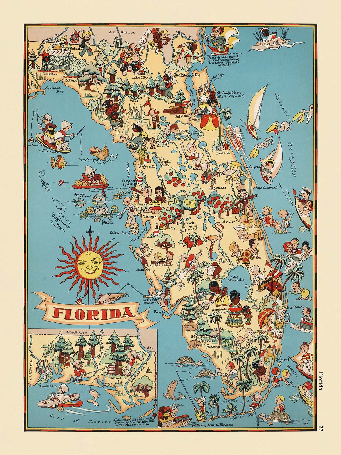
Entrez dans le monde vibrant de la Floride des années 1930 avec la carte picturale captivante intitulée simplement "Floride," créée par la...
Continuer la lectureEntrez dans le monde vibrant de la Floride des années 1930 avec la carte picturale captivante intitulée simplement "Floride," créée par la talentueuse Ruth Taylor White en 1935. Cette œuvre remarquable est plus qu'une représentation géographique ; c'est une célébration du caractère unique de l'État ensoleillé, capturée à travers l'objectif artistique fantaisiste et engageant de White. Le titre original de la carte reflète son ambition large : encapsuler l'essence de la Floride à un moment charnière de son histoire, alors que l'État émergeait comme une destination nationale pour les loisirs, l'agriculture et l'aventure.
Ruth Taylor White était renommée pour son approche ludique mais informative de la cartographie, et cette carte se dresse comme un témoignage de son génie créatif. Son style distinctif mêle palettes de couleurs vives et illustrations de type cartoon, transformant le paysage en un tableau vivant des gens, des industries et des merveilles naturelles de la Floride. Le travail de White faisait partie d'un mouvement plus large dans les années 1930 visant à rendre les cartes à la fois éducatives et divertissantes, invitant les spectateurs de tous âges à explorer et apprécier la diversité du paysage américain.
La carte est vivante avec des représentations imaginatives des caractéristiques les plus emblématiques de la Floride. Des mystérieux Everglades grouillant d'alligators et des Florida Keys baignées de soleil, aux luxuriantes vergers d'orangers et aux vastes champs de canne à sucre, chaque coin de l'État est rendu avec un détail affectueux. La présence de palmiers, de flamants roses et de scènes de pêche et de navigation évoque l'attrait durable de l'État en tant que paradis pour les résidents et les visiteurs. Notamment, White inclut des vignettes de personnes Seminoles et de plongeurs de spongiaires, offrant un clin d'œil au patrimoine indigène de la Floride et aux industries qui ont façonné ses communautés côtières.
Les villes et villages sont méticuleusement étiquetés, chacun niché parmi des illustrations qui suggèrent leur signification historique et culturelle. Jacksonville, Miami, Tampa et Orlando — maintenant des centres urbains animés — sont placés aux côtés de plus petites localités chargées d'histoire comme Key West, St. Augustine et Tarpon Springs. Les scènes ludiques de la carte représentant des terrains de golf, des ranchs de bovins et même de la lutte avec des alligators reflètent à la fois la réalité et la mythologie de la vie en Floride dans les années 1930, en faisant une riche tapisserie de l'identité multifacette de l'État.
Historiquement, cette carte est une fenêtre sur une époque révolue, capturant l'optimisme et l'imagination de l'époque. Elle a été créée pendant la Grande Dépression, une période où les Américains se tournaient vers les cartes et le voyage comme sources d'espoir et d'évasion. L'œuvre de White fait plus que tracer des frontières et des villes — elle encapsule l'esprit de la Floride, invitant les collectionneurs et les passionnés à revenir à une époque où l'État se transformait rapidement, tout en restant profondément ancré dans sa beauté naturelle et ses traditions culturelles. Cette carte n'est pas seulement un morceau d'histoire ; c'est une œuvre d'art qui continue d'inspirer l'émerveillement et l'admiration.
Villes et villages sur cette carte
- Jacksonville
- Miami
- Tampa
- Orlando
- St. Petersburg
- Hialeah
- Fort Lauderdale
- Tallahassee
- Cape Coral
- Port St. Lucie
- Pembroke Pines
- Hollywood
- Gainesville
- Coral Gables
- Key West
- Daytona Beach
- Pensacola
- Lakeland
- Sarasota
- Ocala
- Fort Myers
- St. Augustine
- Sanford
- Winter Haven
- Tarpon Springs
Caractéristiques et monuments notables
- Les Everglades sont illustrées et étiquetées, mettant en évidence l'écosystème unique des zones humides de la Floride.
- Les Keys de Floride sont représentées, soulignant leur importance géographique et culturelle.
- Une illustration d'oranges et de vergers d'orangers, représentant l'industrie des agrumes de la Floride.
- Des palmiers et des plages, symbolisant le climat tropical de la Floride et son attrait en tant que destination touristique.
- Des alligators sont montrés, faisant référence à la faune célèbre de l'État.
- Des voiliers et des sports nautiques, indiquant les activités récréatives dans les zones côtières de la Floride.
- Des illustrations de personnes séminoles, reflétant la présence et le patrimoine culturel des Amérindiens en Floride.
- Des flamants roses, représentant la faune aviaire distinctive de l'État.
- Des scènes de bétail et d'élevage, mettant en avant les activités agricoles.
- Une représentation d'un terrain de golf, faisant référence à la popularité de la Floride en tant que destination de golf.
- Un bateau à vapeur sur une rivière, indiquant les modes de transport historiques.
- Des scènes de pêche, mettant en valeur la réputation de la Floride pour la pêche sportive.
- Une représentation d'un plongeur de l'éponge, faisant référence à l'industrie de l'éponge, en particulier autour de Tarpon Springs.
- Des champs de canne à sucre, représentant la production agricole dans le sud de la Floride.
- Une scène avec un homme luttant contre un alligator, un clin d'œil aux attractions touristiques populaires et aux divertissements de l'époque.
Contexte historique et de design
- Nom de la carte : Floride (titre original tel qu'indiqué sur la carte).
- Cartographe : Ruth Taylor White, une illustratrice notable connue pour ses cartes picturales fantaisistes et colorées dans les années 1930.
- Date de création : 1935.
- Éditeur/contexte : Faisant partie d'une série d'atlas picturaux ou de dessins animés des États-Unis, conçus pour divertir et informer.
- Type de carte : Carte thématique et picturale de comté ou d'État.
- Style artistique : La carte utilise des illustrations vibrantes et ludiques et des représentations de style cartoon pour représenter la culture, l'économie et le mode de vie de la Floride dans les années 1930.
- Thèmes/sujets : Scènes et activités stéréotypées, éléments culturels uniques et points de repère notables de la Floride tels que perçus dans les années 1930.
- Couverture géographique : L'ensemble de l'État de Floride, avec les comtés délimités et étiquetés.
- Importance historique : Réflecteur de la culture populaire et des activités économiques de la Floride durant l'ère de la Grande Dépression, offrant un aperçu de la façon dont l'État était perçu et promu à l'époque.
- Valeur de collection : Très prisée par les collectionneurs et les passionnés de cartes historiques et d'art américain du début du 20e siècle.
- But éducatif : Destinée à divertir et à éduquer les spectateurs sur la géographie et l'identité culturelle de la Floride de manière visuellement engageante.
Veuillez vérifier les images pour vous assurer qu'une ville ou un lieu spécifique est représenté sur cette carte. Vous pouvez également nous contacter et nous demander de vérifier la carte pour vous.
Cette carte a fière allure à toutes les tailles, mais je recommande toujours d'opter pour une taille plus grande si vous avez de l'espace. De cette façon, vous pouvez facilement distinguer tous les détails.
Cette carte est incroyable à des tailles allant jusqu'à 50 pouces (125 cm). Si vous recherchez une carte plus grande, veuillez nous contacter.
Le modèle dans les images de la liste tient la version 18x24 pouces (45x60 cm) de cette carte.
La cinquième image de la liste montre un exemple de mon service de personnalisation de cartes.
Si vous cherchez quelque chose de légèrement différent, consultez ma collection des meilleures anciennes cartes pour voir si quelque chose d'autre attire votre attention.
Veuillez me contacter pour vérifier si un certain emplacement, un point de repère ou une caractéristique est représenté sur cette carte.
Cela ferait un merveilleux cadeau d'anniversaire, de Noël, pour la fête des pères, un départ au travail, un anniversaire de mariage ou une pendaison de crémaillère pour quelqu'un des zones couvertes par cette carte.
Cette carte est disponible en tant qu'impression giclée sur papier mat archival sans acide, ou vous pouvez l'acheter encadrée. Le cadre est un joli cadre noir simple qui convient à la plupart des esthétiques. Veuillez me contacter si vous souhaitez une couleur ou un matériau de cadre différent. Mes cadres sont vitrées avec un acrylique de musée super clair (perspex/acrylite), qui est significativement moins réfléchissant que le verre, plus sûr, et arrivera toujours en parfait état.
This map is also available as a float framed canvas, sometimes known as a shadow gap framed canvas or canvas floater. The map is printed on artist's cotton canvas and then stretched over a handmade box frame. We then "float" the canvas inside a wooden frame, which is available in a range of colours (black, dark brown, oak, antique gold and white). This is a wonderful way to present a map without glazing in front. See some examples of float framed canvas maps and explore the differences between my different finishes.
For something truly unique, this map is also available in "Unique 3D", our trademarked process that dramatically transforms the map so that it has a wonderful sense of depth. We combine the original map with detailed topography and elevation data, so that mountains and the terrain really "pop". For more info and examples of 3D maps, check my Unique 3D page.
Entrez dans le monde vibrant de la Floride des années 1930 avec la carte picturale captivante intitulée simplement "Floride," créée par la talentueuse Ruth Taylor White en 1935. Cette œuvre remarquable est plus qu'une représentation géographique ; c'est une célébration du caractère unique de l'État ensoleillé, capturée à travers l'objectif artistique fantaisiste et engageant de White. Le titre original de la carte reflète son ambition large : encapsuler l'essence de la Floride à un moment charnière de son histoire, alors que l'État émergeait comme une destination nationale pour les loisirs, l'agriculture et l'aventure.
Ruth Taylor White était renommée pour son approche ludique mais informative de la cartographie, et cette carte se dresse comme un témoignage de son génie créatif. Son style distinctif mêle palettes de couleurs vives et illustrations de type cartoon, transformant le paysage en un tableau vivant des gens, des industries et des merveilles naturelles de la Floride. Le travail de White faisait partie d'un mouvement plus large dans les années 1930 visant à rendre les cartes à la fois éducatives et divertissantes, invitant les spectateurs de tous âges à explorer et apprécier la diversité du paysage américain.
La carte est vivante avec des représentations imaginatives des caractéristiques les plus emblématiques de la Floride. Des mystérieux Everglades grouillant d'alligators et des Florida Keys baignées de soleil, aux luxuriantes vergers d'orangers et aux vastes champs de canne à sucre, chaque coin de l'État est rendu avec un détail affectueux. La présence de palmiers, de flamants roses et de scènes de pêche et de navigation évoque l'attrait durable de l'État en tant que paradis pour les résidents et les visiteurs. Notamment, White inclut des vignettes de personnes Seminoles et de plongeurs de spongiaires, offrant un clin d'œil au patrimoine indigène de la Floride et aux industries qui ont façonné ses communautés côtières.
Les villes et villages sont méticuleusement étiquetés, chacun niché parmi des illustrations qui suggèrent leur signification historique et culturelle. Jacksonville, Miami, Tampa et Orlando — maintenant des centres urbains animés — sont placés aux côtés de plus petites localités chargées d'histoire comme Key West, St. Augustine et Tarpon Springs. Les scènes ludiques de la carte représentant des terrains de golf, des ranchs de bovins et même de la lutte avec des alligators reflètent à la fois la réalité et la mythologie de la vie en Floride dans les années 1930, en faisant une riche tapisserie de l'identité multifacette de l'État.
Historiquement, cette carte est une fenêtre sur une époque révolue, capturant l'optimisme et l'imagination de l'époque. Elle a été créée pendant la Grande Dépression, une période où les Américains se tournaient vers les cartes et le voyage comme sources d'espoir et d'évasion. L'œuvre de White fait plus que tracer des frontières et des villes — elle encapsule l'esprit de la Floride, invitant les collectionneurs et les passionnés à revenir à une époque où l'État se transformait rapidement, tout en restant profondément ancré dans sa beauté naturelle et ses traditions culturelles. Cette carte n'est pas seulement un morceau d'histoire ; c'est une œuvre d'art qui continue d'inspirer l'émerveillement et l'admiration.
Villes et villages sur cette carte
- Jacksonville
- Miami
- Tampa
- Orlando
- St. Petersburg
- Hialeah
- Fort Lauderdale
- Tallahassee
- Cape Coral
- Port St. Lucie
- Pembroke Pines
- Hollywood
- Gainesville
- Coral Gables
- Key West
- Daytona Beach
- Pensacola
- Lakeland
- Sarasota
- Ocala
- Fort Myers
- St. Augustine
- Sanford
- Winter Haven
- Tarpon Springs
Caractéristiques et monuments notables
- Les Everglades sont illustrées et étiquetées, mettant en évidence l'écosystème unique des zones humides de la Floride.
- Les Keys de Floride sont représentées, soulignant leur importance géographique et culturelle.
- Une illustration d'oranges et de vergers d'orangers, représentant l'industrie des agrumes de la Floride.
- Des palmiers et des plages, symbolisant le climat tropical de la Floride et son attrait en tant que destination touristique.
- Des alligators sont montrés, faisant référence à la faune célèbre de l'État.
- Des voiliers et des sports nautiques, indiquant les activités récréatives dans les zones côtières de la Floride.
- Des illustrations de personnes séminoles, reflétant la présence et le patrimoine culturel des Amérindiens en Floride.
- Des flamants roses, représentant la faune aviaire distinctive de l'État.
- Des scènes de bétail et d'élevage, mettant en avant les activités agricoles.
- Une représentation d'un terrain de golf, faisant référence à la popularité de la Floride en tant que destination de golf.
- Un bateau à vapeur sur une rivière, indiquant les modes de transport historiques.
- Des scènes de pêche, mettant en valeur la réputation de la Floride pour la pêche sportive.
- Une représentation d'un plongeur de l'éponge, faisant référence à l'industrie de l'éponge, en particulier autour de Tarpon Springs.
- Des champs de canne à sucre, représentant la production agricole dans le sud de la Floride.
- Une scène avec un homme luttant contre un alligator, un clin d'œil aux attractions touristiques populaires et aux divertissements de l'époque.
Contexte historique et de design
- Nom de la carte : Floride (titre original tel qu'indiqué sur la carte).
- Cartographe : Ruth Taylor White, une illustratrice notable connue pour ses cartes picturales fantaisistes et colorées dans les années 1930.
- Date de création : 1935.
- Éditeur/contexte : Faisant partie d'une série d'atlas picturaux ou de dessins animés des États-Unis, conçus pour divertir et informer.
- Type de carte : Carte thématique et picturale de comté ou d'État.
- Style artistique : La carte utilise des illustrations vibrantes et ludiques et des représentations de style cartoon pour représenter la culture, l'économie et le mode de vie de la Floride dans les années 1930.
- Thèmes/sujets : Scènes et activités stéréotypées, éléments culturels uniques et points de repère notables de la Floride tels que perçus dans les années 1930.
- Couverture géographique : L'ensemble de l'État de Floride, avec les comtés délimités et étiquetés.
- Importance historique : Réflecteur de la culture populaire et des activités économiques de la Floride durant l'ère de la Grande Dépression, offrant un aperçu de la façon dont l'État était perçu et promu à l'époque.
- Valeur de collection : Très prisée par les collectionneurs et les passionnés de cartes historiques et d'art américain du début du 20e siècle.
- But éducatif : Destinée à divertir et à éduquer les spectateurs sur la géographie et l'identité culturelle de la Floride de manière visuellement engageante.
Veuillez vérifier les images pour vous assurer qu'une ville ou un lieu spécifique est représenté sur cette carte. Vous pouvez également nous contacter et nous demander de vérifier la carte pour vous.
Cette carte a fière allure à toutes les tailles, mais je recommande toujours d'opter pour une taille plus grande si vous avez de l'espace. De cette façon, vous pouvez facilement distinguer tous les détails.
Cette carte est incroyable à des tailles allant jusqu'à 50 pouces (125 cm). Si vous recherchez une carte plus grande, veuillez nous contacter.
Le modèle dans les images de la liste tient la version 18x24 pouces (45x60 cm) de cette carte.
La cinquième image de la liste montre un exemple de mon service de personnalisation de cartes.
Si vous cherchez quelque chose de légèrement différent, consultez ma collection des meilleures anciennes cartes pour voir si quelque chose d'autre attire votre attention.
Veuillez me contacter pour vérifier si un certain emplacement, un point de repère ou une caractéristique est représenté sur cette carte.
Cela ferait un merveilleux cadeau d'anniversaire, de Noël, pour la fête des pères, un départ au travail, un anniversaire de mariage ou une pendaison de crémaillère pour quelqu'un des zones couvertes par cette carte.
Cette carte est disponible en tant qu'impression giclée sur papier mat archival sans acide, ou vous pouvez l'acheter encadrée. Le cadre est un joli cadre noir simple qui convient à la plupart des esthétiques. Veuillez me contacter si vous souhaitez une couleur ou un matériau de cadre différent. Mes cadres sont vitrées avec un acrylique de musée super clair (perspex/acrylite), qui est significativement moins réfléchissant que le verre, plus sûr, et arrivera toujours en parfait état.
This map is also available as a float framed canvas, sometimes known as a shadow gap framed canvas or canvas floater. The map is printed on artist's cotton canvas and then stretched over a handmade box frame. We then "float" the canvas inside a wooden frame, which is available in a range of colours (black, dark brown, oak, antique gold and white). This is a wonderful way to present a map without glazing in front. See some examples of float framed canvas maps and explore the differences between my different finishes.
For something truly unique, this map is also available in "Unique 3D", our trademarked process that dramatically transforms the map so that it has a wonderful sense of depth. We combine the original map with detailed topography and elevation data, so that mountains and the terrain really "pop". For more info and examples of 3D maps, check my Unique 3D page.
Many of our maps and art prints are chosen as thoughtful gifts for homes, offices, studies and meaningful places.
Choose a framed option for the easiest ready-to-hang gift, or choose an unframed print if the recipient may prefer to select their own frame.
We make orders locally in 23 countries around the world, so gifts can often be produced close to the recipient. This helps them arrive faster, travel more safely, and avoid customs or import duty surprises.
- We can deliver directly to the recipient
- Framed pieces arrive ready to hang
- Unframed prints are carefully packed in a strong protective tube
- Almost every order is made locally, for faster, safer gifting
- 90-day returns give the recipient time to decide
If you are not sure what to choose, please contact us. We can help you pick the right map, size, finish or delivery option.
Pour la plupart des commandes, le délai de livraison est d'environ 3 jours ouvrables. Les produits personnalisés et sur mesure prennent plus de temps, car je dois faire la personnalisation et vous l'envoyer pour approbation, ce qui prend généralement 1 ou 2 jours.
Veuillez noter que les grandes commandes encadrées prennent généralement plus de temps à réaliser et à livrer.
Si vous avez besoin que votre commande arrive à une date précise, veuillez me contacter avant de passer votre commande afin que nous puissions trouver le meilleur moyen de nous assurer que vous receviez votre commande à temps.
J'imprime et encadre des cartes et des œuvres d'art dans 23 pays à travers le monde. Cela signifie que votre commande sera réalisée localement, ce qui réduit le temps de livraison et garantit qu'elle ne sera pas endommagée pendant le transport. Vous ne paierez jamais de droits de douane ou d'importation, et nous mettrons moins de CO2 dans l'air.
Toutes mes cartes et impressions artistiques sont bien emballées et envoyées dans un tube robuste si non encadrées, ou entourées de mousse si encadrées.
J'essaie d'envoyer toutes les commandes dans les 1 ou 2 jours suivant la réception de votre commande, bien que certains produits (comme les masques, les mugs et les sacs fourre-tout) puissent prendre plus de temps à réaliser.
Si vous choisissez Livraison Express lors du paiement, nous donnerons la priorité à votre commande et l'enverrons par un service de messagerie de 1 jour (Fedex, DHL, UPS, Parcelforce).
La livraison le lendemain est également disponible dans certains pays (États-Unis, Royaume-Uni, Singapour, Émirats Arabes Unis), mais veuillez essayer de commander tôt dans la journée afin que nous puissions l'envoyer à temps.
Lisez mon guide complet sur la livraison et la production locale
Mon cadre standard est un cadre en bois dur noir de style galerie. Il est simple et a un aspect assez moderne. Mon cadre standard mesure environ 20 mm (0,8 po) de large.
J'utilise de l'acrylique super clair (perspex/acrylite) pour le verre du cadre. C'est plus léger et plus sûr que le verre - et cela a meilleur aspect, car la réflexivité est plus faible.
Six couleurs de cadre standard sont disponibles gratuitement (noir, marron foncé, gris foncé, chêne, blanc et or antique). Des encadrements et montages/matelassages personnalisés sont disponibles si vous recherchez autre chose.
La plupart des cartes, œuvres d'art et illustrations sont également disponibles sous forme de toile encadrée. Nous utilisons une toile en coton mate (non brillante), que nous tendons sur un cadre en bois de boîte provenant de sources durables, puis nous 'flottions' la pièce à l'intérieur d'un cadre en bois. Le résultat final est assez beau, et il n'y a pas de vitrage qui gêne.
Tous les cadres sont fournis "prêts à accrocher", avec soit une corde, soit des supports à l'arrière. Les très grands cadres auront des plaques de suspension lourdes et/ou une latte de montage. Si vous avez des questions, veuillez nous contacter.
Voir quelques exemples de mes cartes encadrées et de cartes en toile encadrées.
Alternativement, je peux également fournir de vieilles cartes et œuvres d'art sur toile, sur panneau en mousse, en coton et d'autres matériaux.
Si vous souhaitez encadrer votre carte ou œuvre d'art vous-même, veuillez lire d'abord mon guide des tailles.
Mes cartes sont des reproductions de cartes originales de très haute qualité.
Je recherche des cartes originales et rares auprès de bibliothèques, de maisons de ventes aux enchères et de collections privées du monde entier, je les restaure dans mon atelier de Londres, puis j'utilise des encres et des imprimantes giclées spécialisées pour créer de magnifiques cartes encore plus belles que l'originale.
Mes cartes sont imprimées sur du papier d’archives mat (non brillant) sans acide qui semble de très haute qualité et ressemble presque à une carte. En termes techniques, le grammage/épaisseur du papier est de 10 mil/200 g/m². C'est parfait pour l'encadrement.
J’imprime avec des encres pigmentaires Epson ultrachrome giclée UV résistantes à la décoloration – certaines des meilleures encres que vous puissiez trouver.
je peux aussi faire cartes sur toile, chiffon en coton et autres matériaux exotiques.
En savoir plus sur Unique Maps Co..
Personnalisation de la carte
Si vous recherchez le cadeau parfait pour un anniversaire ou une pendaison de crémaillère, je peux personnaliser votre carte pour la rendre vraiment unique. Par exemple, je peux ajouter un court message, mettre en évidence un lieu important ou ajouter les armoiries de votre famille.
Les options sont presque infinies. S'il vous plaît voir mon page de personnalisation de la carte pour quelques merveilleux exemples de ce qui est possible.
Pour commander une carte personnalisée, sélectionnez « personnaliser votre carte » avant de l'ajouter à votre panier.
Entrer en contact si vous recherchez des personnalisations et des personnalisations plus complexes.
Vieillissement de la carte
Au fil des ans, des clients m'ont demandé des centaines de fois s'ils pouvaient acheter une carte qui semble uniforme. plus vieux.
Eh bien, vous pouvez désormais le faire en sélectionnant Aged avant d'ajouter une carte à votre panier.
Toutes les photos de produits que vous voyez sur cette page montrent la carte dans sa forme originale. Voilà à quoi ressemble la carte aujourd'hui.
Si vous sélectionnez Vieilli, je vieillirai votre carte à la main, en utilisant un processus spécial et unique développé au cours d'années d'étude de cartes anciennes, de discussions avec des chercheurs pour comprendre la chimie du vieillissement du papier, et bien sûr... beaucoup de pratique !
Si vous n'êtes pas sûr, respectez la couleur originale de la carte. Si vous voulez quelque chose d'un peu plus sombre et plus vieux à la recherche, optez pour Aged.
Si vous n'êtes pas satisfait de votre commande pour une raison quelconque, contactez-moi pour un remboursement sans conditions. Veuillez consulter notre politique de retours et de remboursements pour plus d'informations.
Je suis très confiant que vous aimerez votre carte restaurée ou votre impression artistique. Je fais cela depuis 1984. Je suis un vendeur Etsy 5 étoiles. J'ai vendu des dizaines de milliers de cartes et d'impressions artistiques et j'ai plus de 5 000 vrais avis 5 étoiles.
J'utilise un processus unique pour restaurer des cartes et des œuvres d'art qui est extrêmement chronophage et exigeant en main-d'œuvre. Trouver les cartes et illustrations originales peut prendre des mois. J'utilise une technologie de pointe et incroyablement coûteuse pour les numériser et les restaurer. En conséquence, je garantis que mes cartes et impressions artistiques sont d'une qualité supérieure - c'est pourquoi je peux offrir un remboursement sans conditions.
Presque toutes mes cartes et impressions artistiques ont l'air incroyables en grandes tailles (200 cm, 6,5 pieds+) et je peux également les encadrer et vous les livrer, via un transporteur spécial surdimensionné. Contactez-moi pour discuter de vos besoins spécifiques.
Or try searching for something!


