


Carte picturale de l'Oklahoma par Ruth Taylor White, 1935: Oklahoma City, Tulsa, champs pétroliers, motifs amérindiens, époque de la poussière
20% de réduction sur 2 — 33% de réduction sur 3
Ajoutez n'importe quel deux articles éligibles à votre panier pour recevoir 20% de réduction. Ajoutez un troisième et il sera offert (équivalent à 33% de réduction lors de l'achat de trois).
Aucun code nécessaire — l'offre s'applique automatiquement au moment du paiement.
Valide sur toutes les cartes standard et les impressions d'art. Vous pouvez mélanger et assortir n'importe quel design.
Si vous souhaitez expédier des articles à plusieurs adresses, veuillez nous contacter avant de passer votre commande.
Les commandes personnalisées et sur mesure sont exclues.
Contactez-nous si vous avez des questions
 Conçu à Londres Fabriqué en Australia
Conçu à Londres • Fabriqué en Australia
Conçu à Londres Fabriqué en Australia
Conçu à Londres • Fabriqué en Australia

Choose your size
Choose your finish


(Plus d’infos)
Message cadeau & finition personnalisée

Si vous souhaitez ajouter un message cadeau, ou une finition (puzzle, panneau en aluminium, etc.) qui n'est pas disponible ici, veuillez le demander dans la "note de commande" lors de votre passage à la caisse.
Chaque commande est fabriquée sur mesure, donc si vous avez besoin d'ajuster légèrement la taille, ou d'imprimer sur un matériau inhabituel, faites-le nous savoir. Nous avons réalisé des milliers de commandes personnalisées au fil des ans, donc il n'y a (presque) rien que nous ne puissions gérer.
Vous pouvez également nous contacter avant de passer votre commande, si vous le souhaitez !

- Made locally for fast, safe delivery
- No import duty or hidden fees
- Need advice? Message us on WhatsApp
Own a piece of history
7,000+ 5 star reviews


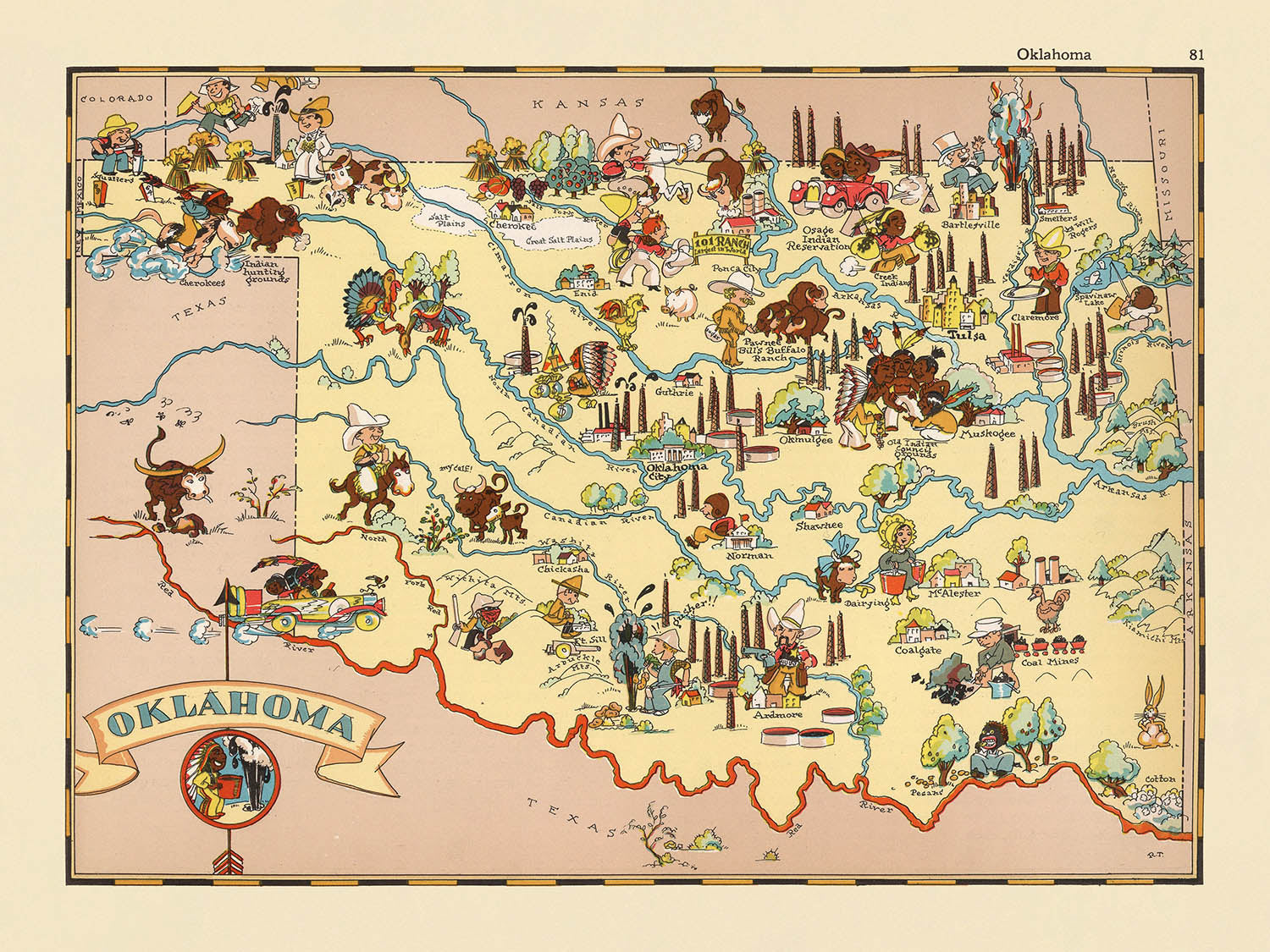
Entrez dans le monde vibrant de l'Oklahoma des années 1930 avec la carte picturale captivante intitulée "Oklahoma," créée par la renommée Ruth Taylor White en 1935. Cette carte est un mélange magistral d'art et de documentation historique, offrant une fenêtre unique sur le caractère et la culture de l'État de Sooner durant une époque charnière. Richement ornée d'illustrations fantaisistes, la carte attire immédiatement l'œil avec ses représentations ludiques de la vie quotidienne, des industries régionales et de la beauté naturelle qui définissait l'Oklahoma au début du XXe siècle. Chaque détail est méticuleusement rendu, faisant de cette carte non seulement un outil de navigation mais aussi un artefact historique vivant qui encapsule l'esprit de son temps.
Ruth Taylor White, célébrée pour ses œuvres cartographiques imaginatives, donne vie à l'Oklahoma à travers son style signature—une fusion engageante d'humour, de couleur et d'insight culturel. Ses cartes, souvent produites en collaboration avec son mari Frank Taylor, sont prisées par les collectionneurs pour leur capacité à transformer la géographie en narration. Ici, la vision artistique de White est pleinement exposée : des derricks pétroliers se dressent au-dessus des plaines, des cowboys et des éleveurs s'occupent du bétail, et des motifs amérindiens honorent l'héritage indigène profond de l'État. Chaque illustration sert un double objectif, à la fois ravissant le spectateur et offrant un aperçu de l'économie diversifiée et des traditions vibrantes de l'Oklahoma.
Le design de la carte témoigne de l'approche thématique et picturale qui a défini l'œuvre de Ruth Taylor White. Les frontières des comtés sont nettement délimitées, invitant à l'exploration des régions variées de l'Oklahoma, tandis que des vignettes colorées mettent en avant l'abondance agricole—des champs de blé, des plants de coton et des équipements agricoles en abondance. La présence de bisons, de tornades et de rivières ancre encore plus la carte dans les réalités physiques et les phénomènes naturels de l'État. Ces éléments non seulement améliorent l'attrait visuel de la carte mais offrent également un aperçu éducatif des paysages et des moyens de subsistance qui ont façonné l'identité de l'Oklahoma durant les années 1930.
Au-delà de son charme esthétique, cette carte offre un contexte historique remarquable. Créée durant l'ère de la Dust Bowl, elle reflète à la fois les défis et la résilience des Oklahomains à une époque où l'État subissait une transformation significative. Les illustrations capturent l'interaction entre tradition et progrès, avec des scènes de musique folklorique et de rodéos aux côtés d'industries en plein essor. Le cartouche décoratif du titre de la carte et les designs de bordure animés renforcent son rôle à la fois d'objet de collection et de pièce de conversation, comblant le fossé entre le passé et le présent avec esprit et chaleur.
Pour ceux qui sont passionnés par l'histoire américaine, la cartographie vintage ou l'histoire unique de l'Oklahoma, cette carte est un trésor de découvertes. Les grandes villes et les towns telles qu'Oklahoma City, Tulsa, Norman et Lawton sont mises en avant, leur signification moderne étant présagée par leur présence sur cette toile historique. La célébration par la carte des icônes culturelles de l'État, des merveilles naturelles et des jalons économiques garantit qu'elle reste un hommage intemporel à l'héritage durable de l'Oklahoma. "Oklahoma" de Ruth Taylor White n'est pas simplement une carte—c'est une tapisserie vibrante, vous invitant à voyager à travers une époque révolue à chaque regard.
Villes et towns sur cette carte
- Oklahoma City
- Tulsa
- Norman
- Lawton
- Broken Arrow
- Edmond
- Moore
- Midwest City
- Enid
- Stillwater
- Muskogee
- Bartlesville
- Shawnee
- Owasso
- Yukon
- Ponca City
- Ardmore
- Duncan
- Del City
- Sapulpa
Caractéristiques et monuments notables
- Les limites des comtés sont clairement délimitées et étiquetées à travers l'Oklahoma.
- Illustrations de derricks de pétrole, faisant référence à l'industrie pétrolière prédominante en Oklahoma.
- Représentations de figures et motifs amérindiens, reflétant l'histoire indigène significative de l'État.
- Illustrations de bovins et de scènes de ranch, mettant en évidence l'économie agricole et d'élevage de l'Oklahoma.
- Images de blé et d'équipements agricoles, représentant l'importance de l'agriculture.
- Dessins de cowboys et de scènes de rodéo, soulignant des thèmes culturels occidentaux.
- Représentations picturales de bisons, symbole des Grandes Plaines et de la faune de l'Oklahoma.
- Illustrations d'instruments de musique et de danseurs, faisant référence aux traditions folkloriques et musicales de l'Oklahoma.
- Images de plants de coton, indiquant la culture du coton dans l'État.
- Références visuelles aux tornades, faisant allusion aux schémas météorologiques de l'Oklahoma.
- Représentations artistiques des rivières et lacs de l'État.
- La carte comprend un cartouche décoratif avec le nom "Oklahoma."
- Illustrations thématiques évoquant l'ère de la poussière, pertinentes à l'histoire de l'Oklahoma des années 1930.
Contexte historique et de conception
- Nom de la carte : Oklahoma.
- Cartographe : Ruth Taylor White.
- Date de création : 1935.
- Faisant partie d'un atlas pictural des États-Unis, connu pour son style fantaisiste et divertissant.
- Style artistique : Richement orné d'illustrations vibrantes et colorées et de représentations ludiques, de style cartoon.
- Thèmes : Scènes stéréotypées de la culture, de l'économie et de la géographie de l'Oklahoma telles que perçues dans les années 1930.
- But : À la fois navigational et décoratif ; sert d'artefact historique reflétant les normes sociétales et l'imagerie populaire de l'Oklahoma au début du 20ème siècle.
- Couverture géographique : L'ensemble de l'État de l'Oklahoma, avec des limites de comté clairement marquées.
- Notable pour : Art fantaisiste et représentation informative, attirant les collectionneurs de cartes vintage et ceux intéressés par l'histoire des États américains.
- Contexte sur le cartographe : Ruth Taylor White était connue pour ses cartes picturales qui combinaient humour, art et contenu informatif, collaborant souvent avec son mari Frank Taylor.
Veuillez vérifier les images pour vous assurer qu'une ville ou un lieu spécifique est représenté sur cette carte. Vous pouvez également nous contacter et nous demander de vérifier la carte pour vous.
Cette carte a fière allure à toutes les tailles, mais je recommande toujours d'opter pour une taille plus grande si vous avez de l'espace. De cette façon, vous pouvez facilement distinguer tous les détails.
Cette carte est magnifique à des tailles allant jusqu'à 50in (125cm). Si vous recherchez une carte plus grande, veuillez nous contacter.
Le modèle dans les images de la liste tient la version 18x24in (45x60cm) de cette carte.
La cinquième image de la liste montre un exemple de mon service de personnalisation de cartes.
Si vous cherchez quelque chose de légèrement différent, consultez ma collection des meilleures anciennes cartes pour voir si quelque chose d'autre attire votre attention.
Veuillez me contacter pour vérifier si un certain emplacement, monument ou caractéristique est représenté sur cette carte.
Ceci ferait un merveilleux cadeau d'anniversaire, de Noël, pour la fête des pères, pour un départ au travail, un anniversaire de mariage ou une pendaison de crémaillère pour quelqu'un des zones couvertes par cette carte.
Cette carte est disponible en tant qu'impression giclée sur papier mat d'archives sans acide, ou vous pouvez l'acheter encadrée. Le cadre est un joli cadre noir simple qui convient à la plupart des esthétiques. Veuillez me contacter si vous souhaitez une couleur ou un matériau de cadre différent. Mes cadres sont vitrifiés avec un acrylique de musée super clair (perspex/acrylite), qui est significativement moins réfléchissant que le verre, plus sûr, et arrivera toujours en parfait état.
This map is also available as a float framed canvas, sometimes known as a shadow gap framed canvas or canvas floater. The map is printed on artist's cotton canvas and then stretched over a handmade box frame. We then "float" the canvas inside a wooden frame, which is available in a range of colours (black, dark brown, oak, antique gold and white). This is a wonderful way to present a map without glazing in front. See some examples of float framed canvas maps and explore the differences between my different finishes.
For something truly unique, this map is also available in "Unique 3D", our trademarked process that dramatically transforms the map so that it has a wonderful sense of depth. We combine the original map with detailed topography and elevation data, so that mountains and the terrain really "pop". For more info and examples of 3D maps, check my Unique 3D page.
Many of our maps and art prints are chosen as thoughtful gifts for homes, offices, studies and meaningful places.
Choose a framed option for the easiest ready-to-hang gift, or choose an unframed print if the recipient may prefer to select their own frame.
We make orders locally in 23 countries around the world, so gifts can often be produced close to the recipient. This helps them arrive faster, travel more safely, and avoid customs or import duty surprises.
- We can deliver directly to the recipient
- Framed pieces arrive ready to hang
- Unframed prints are carefully packed in a strong protective tube
- Almost every order is made locally, for faster, safer gifting
- 90-day returns give the recipient time to decide
If you are not sure what to choose, please contact us. We can help you pick the right map, size, finish or delivery option.
Pour la plupart des commandes, le délai de livraison est d'environ 3 jours ouvrables. Les produits personnalisés et sur mesure prennent plus de temps, car je dois faire la personnalisation et vous l'envoyer pour approbation, ce qui prend généralement 1 ou 2 jours.
Veuillez noter que les grandes commandes encadrées prennent généralement plus de temps à réaliser et à livrer.
Si vous avez besoin que votre commande arrive à une date précise, veuillez me contacter avant de passer votre commande afin que nous puissions trouver le meilleur moyen de nous assurer que vous receviez votre commande à temps.
J'imprime et encadre des cartes et des œuvres d'art dans 23 pays à travers le monde. Cela signifie que votre commande sera réalisée localement, ce qui réduit le temps de livraison et garantit qu'elle ne sera pas endommagée pendant le transport. Vous ne paierez jamais de droits de douane ou d'importation, et nous mettrons moins de CO2 dans l'air.
Toutes mes cartes et impressions artistiques sont bien emballées et envoyées dans un tube robuste si non encadrées, ou entourées de mousse si encadrées.
J'essaie d'envoyer toutes les commandes dans les 1 ou 2 jours suivant la réception de votre commande, bien que certains produits (comme les masques, les mugs et les sacs fourre-tout) puissent prendre plus de temps à réaliser.
Si vous choisissez Livraison Express lors du paiement, nous donnerons la priorité à votre commande et l'enverrons par un service de messagerie de 1 jour (Fedex, DHL, UPS, Parcelforce).
La livraison le lendemain est également disponible dans certains pays (États-Unis, Royaume-Uni, Singapour, Émirats Arabes Unis), mais veuillez essayer de commander tôt dans la journée afin que nous puissions l'envoyer à temps.
Lisez mon guide complet sur la livraison et la production locale
Mon cadre standard est un cadre en bois dur noir de style galerie. Il est simple et a un aspect assez moderne. Mon cadre standard mesure environ 20 mm (0,8 po) de large.
J'utilise de l'acrylique super clair (perspex/acrylite) pour le verre du cadre. C'est plus léger et plus sûr que le verre - et cela a meilleur aspect, car la réflexivité est plus faible.
Six couleurs de cadre standard sont disponibles gratuitement (noir, marron foncé, gris foncé, chêne, blanc et or antique). Des encadrements et montages/matelassages personnalisés sont disponibles si vous recherchez autre chose.
La plupart des cartes, œuvres d'art et illustrations sont également disponibles sous forme de toile encadrée. Nous utilisons une toile en coton mate (non brillante), que nous tendons sur un cadre en bois de boîte provenant de sources durables, puis nous 'flottions' la pièce à l'intérieur d'un cadre en bois. Le résultat final est assez beau, et il n'y a pas de vitrage qui gêne.
Tous les cadres sont fournis "prêts à accrocher", avec soit une corde, soit des supports à l'arrière. Les très grands cadres auront des plaques de suspension lourdes et/ou une latte de montage. Si vous avez des questions, veuillez nous contacter.
Voir quelques exemples de mes cartes encadrées et de cartes en toile encadrées.
Alternativement, je peux également fournir de vieilles cartes et œuvres d'art sur toile, sur panneau en mousse, en coton et d'autres matériaux.
Si vous souhaitez encadrer votre carte ou œuvre d'art vous-même, veuillez lire d'abord mon guide des tailles.
Mes cartes sont des reproductions de cartes originales de très haute qualité.
Je recherche des cartes originales et rares auprès de bibliothèques, de maisons de ventes aux enchères et de collections privées du monde entier, je les restaure dans mon atelier de Londres, puis j'utilise des encres et des imprimantes giclées spécialisées pour créer de magnifiques cartes encore plus belles que l'originale.
Mes cartes sont imprimées sur du papier d’archives mat (non brillant) sans acide qui semble de très haute qualité et ressemble presque à une carte. En termes techniques, le grammage/épaisseur du papier est de 10 mil/200 g/m². C'est parfait pour l'encadrement.
J’imprime avec des encres pigmentaires Epson ultrachrome giclée UV résistantes à la décoloration – certaines des meilleures encres que vous puissiez trouver.
je peux aussi faire cartes sur toile, chiffon en coton et autres matériaux exotiques.
En savoir plus sur Unique Maps Co..
Personnalisation de la carte
Si vous recherchez le cadeau parfait pour un anniversaire ou une pendaison de crémaillère, je peux personnaliser votre carte pour la rendre vraiment unique. Par exemple, je peux ajouter un court message, mettre en évidence un lieu important ou ajouter les armoiries de votre famille.
Les options sont presque infinies. S'il vous plaît voir mon page de personnalisation de la carte pour quelques merveilleux exemples de ce qui est possible.
Pour commander une carte personnalisée, sélectionnez « personnaliser votre carte » avant de l'ajouter à votre panier.
Entrer en contact si vous recherchez des personnalisations et des personnalisations plus complexes.
Vieillissement de la carte
Au fil des ans, des clients m'ont demandé des centaines de fois s'ils pouvaient acheter une carte qui semble uniforme. plus vieux.
Eh bien, vous pouvez désormais le faire en sélectionnant Aged avant d'ajouter une carte à votre panier.
Toutes les photos de produits que vous voyez sur cette page montrent la carte dans sa forme originale. Voilà à quoi ressemble la carte aujourd'hui.
Si vous sélectionnez Vieilli, je vieillirai votre carte à la main, en utilisant un processus spécial et unique développé au cours d'années d'étude de cartes anciennes, de discussions avec des chercheurs pour comprendre la chimie du vieillissement du papier, et bien sûr... beaucoup de pratique !
Si vous n'êtes pas sûr, respectez la couleur originale de la carte. Si vous voulez quelque chose d'un peu plus sombre et plus vieux à la recherche, optez pour Aged.
Si vous n'êtes pas satisfait de votre commande pour une raison quelconque, contactez-moi pour un remboursement sans conditions. Veuillez consulter notre politique de retours et de remboursements pour plus d'informations.
Je suis très confiant que vous aimerez votre carte restaurée ou votre impression artistique. Je fais cela depuis 1984. Je suis un vendeur Etsy 5 étoiles. J'ai vendu des dizaines de milliers de cartes et d'impressions artistiques et j'ai plus de 5 000 vrais avis 5 étoiles.
J'utilise un processus unique pour restaurer des cartes et des œuvres d'art qui est extrêmement chronophage et exigeant en main-d'œuvre. Trouver les cartes et illustrations originales peut prendre des mois. J'utilise une technologie de pointe et incroyablement coûteuse pour les numériser et les restaurer. En conséquence, je garantis que mes cartes et impressions artistiques sont d'une qualité supérieure - c'est pourquoi je peux offrir un remboursement sans conditions.
Presque toutes mes cartes et impressions artistiques ont l'air incroyables en grandes tailles (200 cm, 6,5 pieds+) et je peux également les encadrer et vous les livrer, via un transporteur spécial surdimensionné. Contactez-moi pour discuter de vos besoins spécifiques.
Or try searching for something!


