


Rare Old Colonial Map of Western Australia by Arrowsmith, 1844: Perth inset, Bunbury, Albany, Fremantle, Geraldton
20% de descuento en 2 — 33% de descuento en 3
Añade dos artículos elegibles a tu carrito para recibir 20% de descuento. Añade un tercero y será complementario (equivalente a 33% de descuento al comprar tres).
No se necesita código — la oferta se aplica automáticamente al finalizar la compra.
Válido en todos los mapas estándar y impresiones de arte fino. Puedes mezclar y combinar cualquier diseño.
Si deseas enviar artículos a múltiples direcciones, por favor contáctanos antes de realizar tu pedido.
Las comisiones personalizadas y a medida están excluidas.
Contáctanos si tienes alguna pregunta
 Diseñado en Londres Hecho en Australia
Diseñado en Londres • Hecho en Australia
Diseñado en Londres Hecho en Australia
Diseñado en Londres • Hecho en Australia

Choose your size
Choose your finish


(Más información)
Mensaje de regalo y acabado personalizado

Si deseas agregar un mensaje de regalo, o un acabado (rompecabezas, tablero de aluminio, etc.) que no esté disponible aquí, por favor solicítalo en la "nota del pedido" cuando realices la compra.
Cada pedido es hecho a medida, así que si necesitas que el tamaño se ajuste ligeramente, o que se imprima en un material inusual, háznoslo saber. Hemos realizado miles de pedidos personalizados a lo largo de los años, así que hay (casi) nada que no podamos gestionar.
También puedes contactarnos antes de hacer tu pedido, ¡si lo prefieres!

- Made locally for fast, safe delivery
- No import duty or hidden fees
- Need advice? Message us on WhatsApp
Own a piece of history
7,000+ 5 star reviews


Titled The Colony of Western Australia, John Arrowsmith’s 1844 sheet presents a poised, contemporary vision of a young colony rendered with the clean assurance that made his London Atlas a landmark of the nineteenth century. The title sits within a refined cartouche that balances elegance and restraint, while the land is divided into counties picked out in delicate outline color, a modern aesthetic choice that heightens legibility without showmanship. Political boundaries are crisply declared, towns cleanly lettered, and rivers and capes traced with judicious exactitude. Issued during the London Atlas’s most innovative period—when additional sheets dated 1844 expanded its remit—this map embodies Arrowsmith’s celebrated clarity, framing Western Australia at a pivotal moment when official surveys, coastal soundings, and the first inland traverses were beginning to cohere into a persuasive geography.
Arrowsmith’s draughtsmanship favors structure over ornament, so the geography speaks first: an intricately serrated coastline, bays and headlands precisely notated, and a river network that anchors settlement to water. Major towns and ports—Perth, Fremantle, Albany, Bunbury, and Geraldton among them—are clearly labeled, their roles within a growing maritime and overland system unmistakable. Political boundaries are distinguished in distinct colors, guiding the eye across counties and districts while preserving the primacy of terrain. An inset focuses on Perth and its environs, distilling the Swan River’s sinuous course, the relationship between the colonial capital and its harbor at Fremantle, and the emerging roadways that ran between them and out toward southern settlements. Routes radiate from these nuclei, mapping the measured reach of administration and commerce across a vast littoral.
Historically, the sheet captures the colony in its formative decades, when European understanding of the continent’s west was advancing from the shore inward. The maritime frame—etched over centuries by Dutch and British navigators—meets colonial surveys that anchor the Swan River Colony and the southern outpost at King George Sound, while inland tracts remain spacious, suggestive, and ripe for future discovery. Rivers such as the Swan, Canning, Avon, Murray, and Blackwood are carefully plotted, not merely as hydrographic facts but as the lifelines along which agriculture, timber, and pastoral interests would take hold. The map’s early road connections, threading Perth to Fremantle, Albany, and Bunbury, register the colony’s immediate logistical needs, even as the interior beyond Geraldton and toward later goldfields around Kalgoorlie-Boulder stands as an invitation to exploration.
John Arrowsmith’s authority lies as much in method as in line. Nephew to Aaron Arrowsmith, he distilled Admiralty charts, colonial surveys, and explorers’ journals into maps whose economy of style masked a wealth of vetted intelligence. The London Atlas—praised for its understated elegance and exemplary clarity—set a new standard for modern cartography, replacing decorative flourishes with disciplined typography, precise engraving, and a rigorous hierarchy of information. In this Western Australia sheet, that philosophy is unmistakable: counties glow with restrained outline color; typography differentiates towns, rivers, and coastal features without crowding; and the cartouche provides title and authorship with cool authority. The result is at once beautiful and useful, a document whose beauty emerges from its exactness and its careful orchestration of spatial knowledge.
Within the broader context of the London Atlas—whose 1842 edition offered a sweeping view of Africa, Asia, Australia, and the Caribbean and was augmented by rare sheets dated 1844—this map stands out for the freshness of its colonial intelligence and the tact with which it is presented. It records Western Australia before statehood, at a moment when political divisions were newly inscribed, settlement was consolidating, and routes stitched isolated communities into a nascent network. Unrecorded in major collections and exemplary of Arrowsmith’s peak period, it distills an era’s ambitions and uncertainties into a legible whole: a finely balanced portrait where colored borders, named towns, and carefully chased rivers converge to show a colony poised between shoreline certainty and interior possibility.
Cities and towns on this map
- Perth (modern population: approx. 2 million)
- Fremantle (modern population: approx. 30,000)
- Albany (modern population: approx. 40,000)
- Bunbury (modern population: approx. 90,000)
- Geraldton (modern population: approx. 30,000)
- Kalgoorlie-Boulder (modern population: approx. 30,000)
Notable Features & Landmarks
- Political boundaries marked with distinct colors.
- Major towns and rivers labeled.
- Detailed depiction of the coastline and geographical features.
- Insets showing specific areas, such as the city of Perth and surrounding regions.
- Roadways and routes connecting various settlements.
- The cartouche providing the title, author, and publication details.
Historical and design context
- Noted for understated elegance and clarity, marking it as one of the first modern atlases of the 19th century.
- The 1842 edition features fifty sheets with additional maps, including rare maps dated 1844.
- Offers insights into regions like Africa, Asia, Australia, and the Caribbean during that period.
- The atlas is unrecorded in major collections, highlighting its uniqueness and rarity.
- Bound in half-leather brown boards with "The London Atlas, by J. Arrowsmith." embossed on the cover.
- Most maps are in outline color, with inset maps remaining uncolored.
- Clear and colorful outline for different counties, offering a modern aesthetic for the time.
- Usage of labeled cartouche detailing the map's title and author in a clear, elegant style.
- Reflects the early cartographic efforts of European settlers and their understanding of Australian geography.
- Captures a moment in time in Western Australia's development before it became a state.
Please double check the images to make sure that a specific town or place is shown on this map. You can also get in touch and ask us to check the map for you.
This map looks great at every size, but I always recommend going for a larger size if you have space. That way you can easily make out all of the details.
This map looks amazing at sizes all the way up to 70in (180cm). If you are looking for a larger map, please get in touch.
Please note: the labels on this map are hard to read if you order a map that is 16in (40cm) or smaller. The map is still very attractive, but if you would like to read the map easily, please buy a larger size.
The model in the listing images is holding the 16x20in (40x50cm) version of this map.
The fifth listing image shows an example of my map personalisation service.
If you’re looking for something slightly different, check out my collection of the best old maps to see if something else catches your eye.
Please contact me to check if a certain location, landmark or feature is shown on this map.
This would make a wonderful birthday, Christmas, Father's Day, work leaving, anniversary or housewarming gift for someone from the areas covered by this map.
This map is available as a giclée print on acid free archival matte paper, or you can buy it framed. The frame is a nice, simple black frame that suits most aesthetics. Please get in touch if you'd like a different frame colour or material. My frames are glazed with super-clear museum-grade acrylic (perspex/acrylite), which is significantly less reflective than glass, safer, and will always arrive in perfect condition.
This map is also available as a float framed canvas, sometimes known as a shadow gap framed canvas or canvas floater. The map is printed on artist's cotton canvas and then stretched over a handmade box frame. We then "float" the canvas inside a wooden frame, which is available in a range of colours (black, dark brown, oak, antique gold and white). This is a wonderful way to present a map without glazing in front. See some examples of float framed canvas maps and explore the differences between my different finishes.
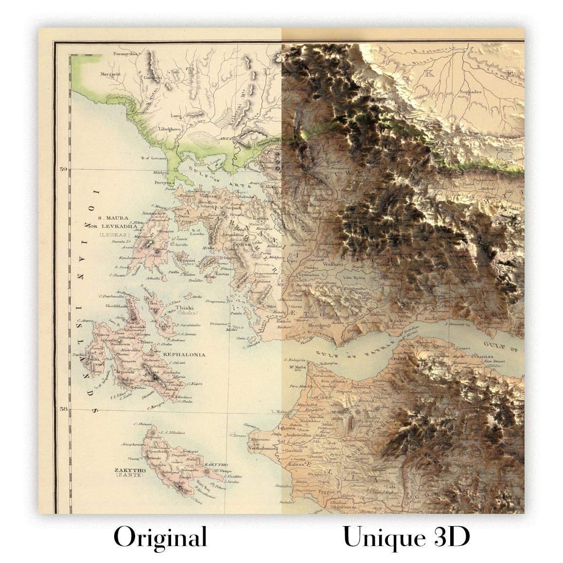
For something truly unique, this map is also available in "Unique 3D", our trademarked process that dramatically transforms the map so that it has a wonderful sense of depth. We combine the original map with detailed topography and elevation data, so that mountains and the terrain really "pop". For more info and examples of 3D maps, check my Unique 3D page.
Many of our maps and art prints are chosen as thoughtful gifts for homes, offices, studies and meaningful places.
Choose a framed option for the easiest ready-to-hang gift, or choose an unframed print if the recipient may prefer to select their own frame.
We make orders locally in 23 countries around the world, so gifts can often be produced close to the recipient. This helps them arrive faster, travel more safely, and avoid customs or import duty surprises.
- We can deliver directly to the recipient
- Framed pieces arrive ready to hang
- Unframed prints are carefully packed in a strong protective tube
- Almost every order is made locally, for faster, safer gifting
- 90-day returns give the recipient time to decide
If you are not sure what to choose, please contact us. We can help you pick the right map, size, finish or delivery option.
Para la mayoría de los pedidos, el tiempo de entrega es de aproximadamente 3 días laborables. Los productos personalizados y a medida tardan más, ya que tengo que hacer la personalización y enviártelo para su aprobación, lo cual suele tardar 1 o 2 días.
Tenga en cuenta que los pedidos enmarcados muy grandes suelen tardar más en fabricarse y entregarse.
Si necesitas que tu pedido llegue para una fecha determinada, por favor contáctame antes de hacer el pedido para que podamos encontrar la mejor manera de asegurarnos de que recibas tu pedido a tiempo.
Imprimo y enmarco mapas y obras de arte en 23 países alrededor del mundo. Esto significa que tu pedido se fabricará localmente, lo que reduce el tiempo de entrega y asegura que no se dañe durante el envío. Nunca pagarás aranceles de aduana o impuestos de importación, y pondremos menos CO2 en el aire.
Todos mis mapas y impresiones artísticas están bien empaquetados y enviados en un tubo resistente si no están enmarcados, o rodeados de espuma si están enmarcados.
Intento enviar todos los pedidos dentro de 1 o 2 días después de recibir tu pedido, aunque algunos productos (como mascarillas, tazas y bolsas de tela) pueden tardar más en fabricarse.
Si seleccionas Entrega Exprés al finalizar la compra, priorizaremos tu pedido y lo enviaremos por mensajería de 1 día (Fedex, DHL, UPS, Parcelforce).
La entrega al día siguiente también está disponible en algunos países (EE. UU., Reino Unido, Singapur, EAU), pero por favor intenta hacer tu pedido temprano en el día para que podamos enviarlo a tiempo.
Mi marco estándar es un marco de madera de fresno negro estilo galería. Es simple y tiene un aspecto bastante moderno. Mi marco estándar tiene alrededor de 20 mm (0.8 in) de ancho.
Utilizo acrílico super claro (perspex/acrylite) para el vidrio del marco. Es más ligero y seguro que el vidrio, y se ve mejor, ya que la reflectividad es menor.
Seis colores de marco estándar están disponibles de forma gratuita (negro, marrón oscuro, gris oscuro, roble, blanco y oro antiguo).El enmarcado y montaje/matizado personalizado está disponible si buscas algo diferente.
La mayoría de los mapas, arte e ilustraciones también están disponibles como un lienzo enmarcado. Utilizamos lienzo de algodón mate (no brillante), lo estiramos sobre un marco de madera de caja de origen sostenible, y luego 'flotamos' la pieza dentro de un marco de madera. El resultado final es bastante hermoso, y no hay cristal que se interponga.
Todos los marcos se proporcionan "listos para colgar", con una cuerda o soportes en la parte posterior. Los marcos muy grandes tendrán placas de colgar de alta resistencia y/o un listón de montaje. Si tienes alguna pregunta, por favor ponte en contacto.
Mira algunos ejemplos de mis mapas enmarcados y mapas en lienzo enmarcados.
Alternativamente, también puedo proporcionar mapas antiguos y obras de arte en lienzo, tablero de espuma, papel de algodón y otros materiales.
Si deseas enmarcar tu mapa o obra de arte tú mismo, por favor lee mi guía de tamaños primero.
Mis mapas son reproducciones de mapas originales de altísima calidad.
Obtengo mapas originales y raros de bibliotecas, casas de subastas y colecciones privadas de todo el mundo, los restauro en mi taller de Londres y luego uso tintas e impresoras giclée especializadas para crear hermosos mapas que lucen incluso mejor que el original.
Mis mapas están impresos en papel de archivo mate (no brillante) sin ácido que se siente de muy alta calidad y casi como una tarjeta. En términos técnicos, el peso/grosor del papel es de 10 mil/200 g/m². Es perfecto para enmarcar.
Imprimo con tintas pigmentadas Epson ultrachrome giclée UV resistentes a la decoloración, algunas de las mejores tintas que puedes encontrar.
yo también puedo hacer mapas sobre lienzo, trapo de algodón y otros materiales exóticos.
Obtenga más información sobre The Unique Maps Co..
Personalización de mapas
Si está buscando el regalo perfecto de aniversario o inauguración de la casa, puedo personalizar su mapa para hacerlo verdaderamente único. Por ejemplo, puedo agregar un mensaje corto, resaltar una ubicación importante o agregar el escudo de armas de su familia.
Las opciones son casi infinitas. Por favor mira mi página de personalización de mapas para ver algunos maravillosos ejemplos de lo que es posible.
Para pedir un mapa personalizado, seleccione "personalizar su mapa" antes de agregarlo a su carrito.
Ponerse en contacto si buscas personalizaciones y personalizaciones más complejas.
Envejecimiento del mapa
A lo largo de los años, los clientes me han preguntado cientos de veces si podían comprar un mapa que se viera uniforme. más viejo.
Bueno, ahora puedes hacerlo seleccionando Envejecido antes de agregar un mapa a tu carrito.
Todas las fotografías de productos que ve en esta página muestran el mapa en su forma original. Así es como se ve el mapa hoy.
Si selecciona Envejecido, envejeceré su mapa a mano, usando un proceso especial y único desarrollado a través de años de estudiar mapas antiguos, hablar con investigadores para comprender la química del envejecimiento del papel y, por supuesto... ¡mucha práctica!
Si no estás seguro, quédate con el color original del mapa. Si quieres algo un poco más oscuro y más viejo buscando, opte por Envejecido.
Si no estás satisfecho con tu pedido por cualquier motivo, contáctame para un reembolso sin complicaciones. Por favor, consulta nuestra política de devoluciones y reembolsos para más información.
Estoy muy seguro de que te gustará tu mapa o impresión artística restaurada. He estado haciendo esto desde 1984. Soy un vendedor de 5 estrellas en Etsy. He vendido decenas de miles de mapas e impresiones artísticas y tengo más de 5,000 opiniones reales de 5 estrellas.
Utilizo un proceso único para restaurar mapas y obras de arte que consume mucho tiempo y mano de obra. Buscar los mapas e ilustraciones originales puede llevar meses. Utilizo tecnología de última generación y extremadamente cara para escanear y restaurarlos. Como resultado, garantizo que mis mapas e impresiones artísticas son superiores a los demás - por eso puedo ofrecer un reembolso sin complicaciones.
Casi todos mis mapas e impresiones artísticas se ven increíbles en tamaños grandes (200cm, 6.5ft+) y también puedo enmarcarlos y entregártelos a través de un servicio de mensajería especial para tamaños grandes. Contáctame para discutir tus necesidades específicas.
Or try searching for something!


