


Mapa antiguo del norte de Italia de Tallis, 1851: Venecia, Alpes, Basílica de San Pedro, Lago de Garda
La oferta del coleccionista
Elija dos obras elegibles y obtenga un 20 % de descuento en ambas. Elija tres y la de menor precio será gratuita, con un ahorro máximo del 33 %.
Combine y mezcle mapas estándar elegibles y reproducciones de bellas artes. No se requiere código; la oferta se aplica automáticamente al finalizar la compra.
Se incluyen las configuraciones estándar hechas por encargo. Quedan excluidos los tamaños a medida, los diseños personalizados y los trabajos por encargo.
¿Necesita entrega en diferentes direcciones? Contáctenos antes de realizar el pedido.La oferta del coleccionista
Elija dos obras elegibles y obtenga un 20 % de descuento en ambas. Elija tres y la de menor precio será gratuita, con un ahorro máximo del 33 %.
Combine y mezcle mapas estándar elegibles y reproducciones de bellas artes. No se requiere código; la oferta se aplica automáticamente al finalizar la compra.
Se incluyen las configuraciones estándar hechas por encargo. Quedan excluidos los tamaños a medida, los diseños personalizados y los trabajos por encargo.
¿Necesita entrega en diferentes direcciones? Contáctenos antes de realizar el pedido. Diseñado en Londres Hecho en Australia
Diseñado en Londres • Hecho en Australia
Diseñado en Londres Hecho en Australia
Diseñado en Londres • Hecho en Australia

Restaurado a partir del mapa original de 1851 e impreso en calidad museo. Leer la historia detrás de este mapa
Choose your size
Choose your finish


(Más información)
Mensaje de regalo y acabado personalizado

Si deseas agregar un mensaje de regalo, o un acabado (rompecabezas, tablero de aluminio, etc.) que no esté disponible aquí, por favor solicítalo en la "nota del pedido" cuando realices la compra.
Cada pedido es hecho a medida, así que si necesitas que el tamaño se ajuste ligeramente, o que se imprima en un material inusual, háznoslo saber. Hemos realizado miles de pedidos personalizados a lo largo de los años, así que hay (casi) nada que no podamos gestionar.
También puedes contactarnos antes de hacer tu pedido, ¡si lo prefieres!

- Hecho localmente. Entrega segura
- Sin aranceles ni cargos ocultos
- ¿Necesitas ayuda? Llámanos o mensaje por WhatsApp
Own a piece of history
8,000+ five-star reviews


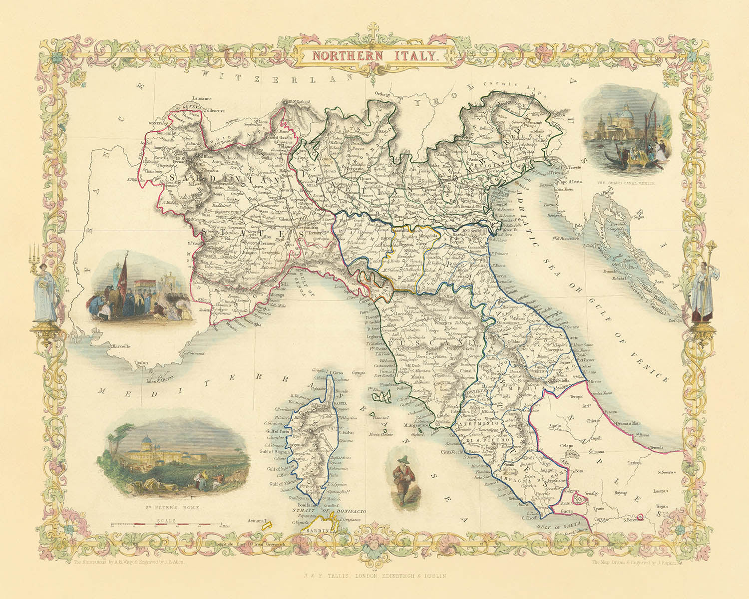
Adéntrese en la grandeza de la cartografía del siglo XIX con "Northern Italy," un exquisito mapa originalmente grabado por John Tallis en...
Seguir leyendoAdéntrese en la grandeza de la cartografía del siglo XIX con "Northern Italy," un exquisito mapa originalmente grabado por John Tallis en 1851 para el célebre Illustrated Atlas de R. Montgomery Martin. El título completo del mapa, “Northern Italy,” refleja su cobertura integral de los intrincados paisajes políticos y físicos de la región en una época de profundo cambio histórico. Creado en los albores de la unificación de Italia, este mapa ofrece una visión cautivadora de un mosaico de ducados, reinos y ciudades-estado independientes, cada uno representado con precisión y arte. El estilo decorativo característico de Tallis, con sus bordes ornamentados y viñetas detalladas, eleva esta pieza de mero registro cartográfico a auténtica obra de arte.
John Tallis, uno de los últimos grandes cartógrafos decorativos, era célebre por su capacidad para combinar la precisión geográfica con la narrativa visual. Sus mapas son apreciados por sus elaborados adornos y escenas evocadoras, y este mapa de Northern Italy no es la excepción. Las viñetas decorativas—como el bullicioso Gran Canal de Venecia y la majestuosa Basílica de San Pedro en Roma—invitan al espectador a recorrer el corazón cultural de Italia. Estos ornamentos artísticos no solo muestran el dominio técnico de Tallis, sino también su aprecio por el espíritu y la vitalidad de las regiones que representó.
El diseño del mapa es una armoniosa unión de geografía política y física. Delimita minuciosamente las fronteras de los diversos estados y provincias que existían antes de la unificación italiana, captando la compleja historia y las lealtades cambiantes de la región. Las montañas alpinas se elevan en un elegante relieve a lo largo del borde norte, mientras que las fértiles llanuras de la cuenca del río Po se extienden por el corazón del mapa. Los principales ríos, como el Po, y lagos emblemáticos como Garda, Como y Maggiore, están representados con claridad, subrayando los rasgos naturales que han dado forma a la historia y al desarrollo del norte de Italia.
Más allá de su belleza física, el mapa es un tesoro de contexto histórico y cultural. Señala la ubicación de célebres ciudades y localidades—Milán, Venecia, Florencia, Génova, Bolonia y muchas más—cada una un centro de arte, comercio e innovación. La cuidada representación de estos asentamientos, ordenados según su importancia, ofrece una fascinante instantánea de la vida urbana a mediados del siglo XIX. Se invita al espectador a trazar las conexiones entre estas grandes ciudades, imaginando el flujo de ideas, bienes y personas a través de un paisaje que, en aquel momento, estaba a la vez dividido y en dinámica evolución.
La inclusión de bordes decorativos y viñetas artísticas distingue a este mapa como una pieza de coleccionista, encarnando la cima de la cartografía de la era victoriana. La obra de Tallis es celebrada no solo por su precisión cartográfica, sino también por su evocadora sensación de lugar y tiempo. Poseer este mapa es tener una ventana abierta a una era decisiva de la historia italiana, cuando los sueños de unificación apenas comenzaban a despertar. Es un testimonio del perdurable atractivo de los paisajes, las ciudades y el patrimonio cultural de Italia—una pieza de herencia para quienes aprecian tanto el arte como la ciencia de la cartografía.
Ciudades y localidades en este mapa
- Milán
- Roma
- Venecia
- Florencia
- Bolonia
- Verona
- Padua (Padova)
- Génova (Genova)
- Parma
- Módena
- Ferrara
- Mantua (Mantova)
- Pisa
- Lucca
- Cremona
- Vicenza
- Rávena
- Livorno
- Alessandria
- Bérgamo
- Brescia
- Como
- Novara
- Pavía
- Piacenza
- Treviso
- Udine
- Ancona
- Rimini
- Siena
- Asti
- Vercelli
Características destacadas y lugares emblemáticos
- Vigneta del Gran Canal de Venecia, que pone de relieve los emblemáticos canales y la arquitectura de la ciudad.
- Vigneta que representa la Basílica de San Pedro en Roma, ilustrando su grandeza arquitectónica y su importancia religiosa.
- Borde decorativo y enmarcado artístico característicos de los mapas de Tallis, con intrincados patrones y ornamentos.
- Fronteras políticas claramente delimitadas de los diversos estados y ducados independientes del norte de Italia en 1851.
- Los principales ríos y lagos, como el río Po, el lago de Garda, el lago de Como y el lago Mayor, se muestran de forma destacada.
- Las cordilleras, en particular los Alpes, se representan con claridad, destacando la geografía física de la región.
- Perfiles costeros y bahías importantes a lo largo de los mares de Liguria y Adriático.
Contexto histórico y de diseño
- Creado por John Tallis en 1851, uno de los últimos grandes cartógrafos decorativos del siglo XIX.
- Grabado para el Illustrated Atlas de R. Montgomery Martin, una reconocida publicación cartográfica del siglo XIX.
- Refleja la fragmentación política de Italia antes de la unificación, con un mosaico de estados, ducados y reinos independientes.
- Presenta el estilo decorativo característico de Tallis, conocido por sus elaborados bordes y viñetas artísticas que ilustran escenas locales, lugares emblemáticos y elementos culturales.
- Ofrece una visión completa de la geografía y las fronteras políticas del norte de Italia durante una época crucial de la historia italiana.
Por favor, compruebe detenidamente las imágenes para asegurarse de que este mapa muestra una ciudad o lugar concreto. También puede ponerse en contacto con nosotros y pedirnos que revisemos el mapa por usted.
Este mapa queda estupendo en cualquier tamaño, pero siempre recomiendo optar por un tamaño mayor si dispone de espacio. Así podrá apreciar fácilmente todos los detalles.
Este mapa se ve increíble en tamaños de hasta 50in (125cm). Si busca un mapa más grande, por favor póngase en contacto.
La modelo de las imágenes del anuncio sostiene la versión de 16x20in (40x50cm) de este mapa.
La quinta imagen del anuncio muestra un ejemplo de mi servicio de personalización de mapas.
Si busca algo ligeramente distinto, eche un vistazo a mi colección de los mejores mapas antiguos para ver si algo más llama su atención.
Por favor, contácteme para comprobar si una determinada ubicación, lugar emblemático o elemento aparece en este mapa.
Sería un regalo maravilloso de cumpleaños, Navidad, Día del Padre, despedida del trabajo, aniversario o inauguración de casa para alguien de las zonas cubiertas por este mapa.
Este mapa está disponible como impresión giclée en papel mate de archivo libre de ácido, o puede adquirirse enmarcado. El marco es un sencillo y elegante marco negro que se adapta a la mayoría de las estéticas. Por favor, póngase en contacto si desea otro color o material para el marco. Nuestros marcos llevan un acristalamiento de acrílico de calidad museística, ultratransparente (perspex/acrylite), que es considerablemente menos reflectante que el vidrio, más seguro y siempre llegará en perfectas condiciones.
This map is also available as a float framed canvas, sometimes known as a shadow gap framed canvas or canvas floater. The map is printed on artist's cotton canvas and then stretched over a handmade box frame. We then "float" the canvas inside a wooden frame, which is available in a range of colours (black, dark brown, oak, antique gold and white). This is a wonderful way to present a map without glazing in front. See some examples of float framed canvas maps and explore the differences between my different finishes.
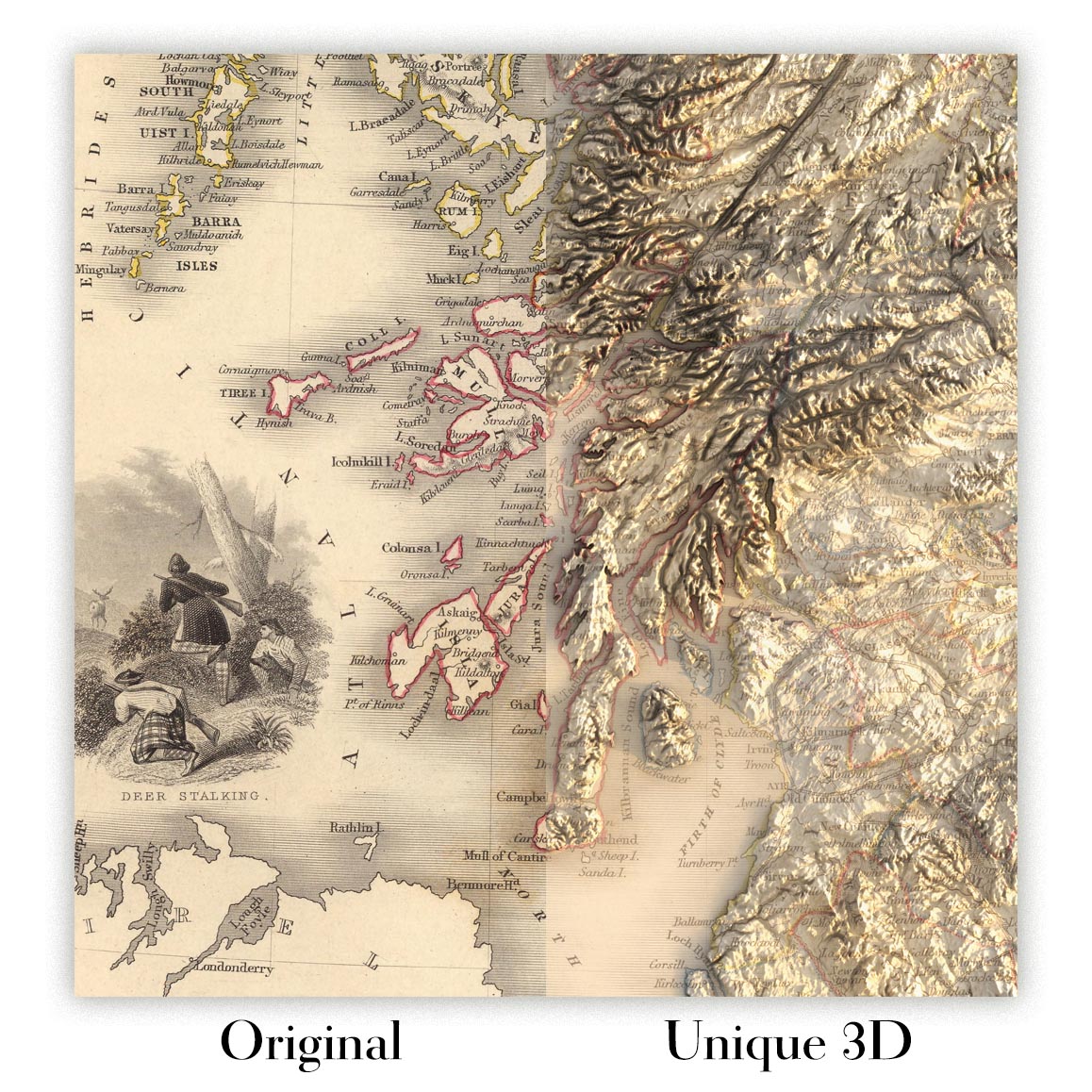
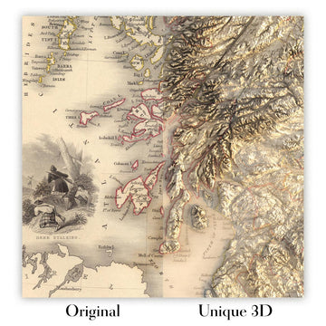
For something truly unique, this map is also available in "Unique 3D", our trademarked process that dramatically transforms the map so that it has a wonderful sense of depth. We combine the original map with detailed topography and elevation data, so that mountains and the terrain really "pop". For more info and examples of 3D maps, check my Unique 3D page.
Adéntrese en la grandeza de la cartografía del siglo XIX con "Northern Italy," un exquisito mapa originalmente grabado por John Tallis en 1851 para el célebre Illustrated Atlas de R. Montgomery Martin. El título completo del mapa, “Northern Italy,” refleja su cobertura integral de los intrincados paisajes políticos y físicos de la región en una época de profundo cambio histórico. Creado en los albores de la unificación de Italia, este mapa ofrece una visión cautivadora de un mosaico de ducados, reinos y ciudades-estado independientes, cada uno representado con precisión y arte. El estilo decorativo característico de Tallis, con sus bordes ornamentados y viñetas detalladas, eleva esta pieza de mero registro cartográfico a auténtica obra de arte.
John Tallis, uno de los últimos grandes cartógrafos decorativos, era célebre por su capacidad para combinar la precisión geográfica con la narrativa visual. Sus mapas son apreciados por sus elaborados adornos y escenas evocadoras, y este mapa de Northern Italy no es la excepción. Las viñetas decorativas—como el bullicioso Gran Canal de Venecia y la majestuosa Basílica de San Pedro en Roma—invitan al espectador a recorrer el corazón cultural de Italia. Estos ornamentos artísticos no solo muestran el dominio técnico de Tallis, sino también su aprecio por el espíritu y la vitalidad de las regiones que representó.
El diseño del mapa es una armoniosa unión de geografía política y física. Delimita minuciosamente las fronteras de los diversos estados y provincias que existían antes de la unificación italiana, captando la compleja historia y las lealtades cambiantes de la región. Las montañas alpinas se elevan en un elegante relieve a lo largo del borde norte, mientras que las fértiles llanuras de la cuenca del río Po se extienden por el corazón del mapa. Los principales ríos, como el Po, y lagos emblemáticos como Garda, Como y Maggiore, están representados con claridad, subrayando los rasgos naturales que han dado forma a la historia y al desarrollo del norte de Italia.
Más allá de su belleza física, el mapa es un tesoro de contexto histórico y cultural. Señala la ubicación de célebres ciudades y localidades—Milán, Venecia, Florencia, Génova, Bolonia y muchas más—cada una un centro de arte, comercio e innovación. La cuidada representación de estos asentamientos, ordenados según su importancia, ofrece una fascinante instantánea de la vida urbana a mediados del siglo XIX. Se invita al espectador a trazar las conexiones entre estas grandes ciudades, imaginando el flujo de ideas, bienes y personas a través de un paisaje que, en aquel momento, estaba a la vez dividido y en dinámica evolución.
La inclusión de bordes decorativos y viñetas artísticas distingue a este mapa como una pieza de coleccionista, encarnando la cima de la cartografía de la era victoriana. La obra de Tallis es celebrada no solo por su precisión cartográfica, sino también por su evocadora sensación de lugar y tiempo. Poseer este mapa es tener una ventana abierta a una era decisiva de la historia italiana, cuando los sueños de unificación apenas comenzaban a despertar. Es un testimonio del perdurable atractivo de los paisajes, las ciudades y el patrimonio cultural de Italia—una pieza de herencia para quienes aprecian tanto el arte como la ciencia de la cartografía.
Ciudades y localidades en este mapa
- Milán
- Roma
- Venecia
- Florencia
- Bolonia
- Verona
- Padua (Padova)
- Génova (Genova)
- Parma
- Módena
- Ferrara
- Mantua (Mantova)
- Pisa
- Lucca
- Cremona
- Vicenza
- Rávena
- Livorno
- Alessandria
- Bérgamo
- Brescia
- Como
- Novara
- Pavía
- Piacenza
- Treviso
- Udine
- Ancona
- Rimini
- Siena
- Asti
- Vercelli
Características destacadas y lugares emblemáticos
- Vigneta del Gran Canal de Venecia, que pone de relieve los emblemáticos canales y la arquitectura de la ciudad.
- Vigneta que representa la Basílica de San Pedro en Roma, ilustrando su grandeza arquitectónica y su importancia religiosa.
- Borde decorativo y enmarcado artístico característicos de los mapas de Tallis, con intrincados patrones y ornamentos.
- Fronteras políticas claramente delimitadas de los diversos estados y ducados independientes del norte de Italia en 1851.
- Los principales ríos y lagos, como el río Po, el lago de Garda, el lago de Como y el lago Mayor, se muestran de forma destacada.
- Las cordilleras, en particular los Alpes, se representan con claridad, destacando la geografía física de la región.
- Perfiles costeros y bahías importantes a lo largo de los mares de Liguria y Adriático.
Contexto histórico y de diseño
- Creado por John Tallis en 1851, uno de los últimos grandes cartógrafos decorativos del siglo XIX.
- Grabado para el Illustrated Atlas de R. Montgomery Martin, una reconocida publicación cartográfica del siglo XIX.
- Refleja la fragmentación política de Italia antes de la unificación, con un mosaico de estados, ducados y reinos independientes.
- Presenta el estilo decorativo característico de Tallis, conocido por sus elaborados bordes y viñetas artísticas que ilustran escenas locales, lugares emblemáticos y elementos culturales.
- Ofrece una visión completa de la geografía y las fronteras políticas del norte de Italia durante una época crucial de la historia italiana.
Por favor, compruebe detenidamente las imágenes para asegurarse de que este mapa muestra una ciudad o lugar concreto. También puede ponerse en contacto con nosotros y pedirnos que revisemos el mapa por usted.
Este mapa queda estupendo en cualquier tamaño, pero siempre recomiendo optar por un tamaño mayor si dispone de espacio. Así podrá apreciar fácilmente todos los detalles.
Este mapa se ve increíble en tamaños de hasta 50in (125cm). Si busca un mapa más grande, por favor póngase en contacto.
La modelo de las imágenes del anuncio sostiene la versión de 16x20in (40x50cm) de este mapa.
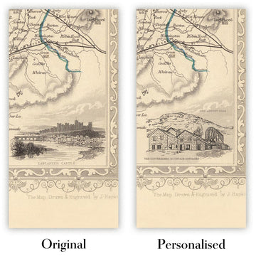
La quinta imagen del anuncio muestra un ejemplo de mi servicio de personalización de mapas.
Si busca algo ligeramente distinto, eche un vistazo a mi colección de los mejores mapas antiguos para ver si algo más llama su atención.
Por favor, contácteme para comprobar si una determinada ubicación, lugar emblemático o elemento aparece en este mapa.
Sería un regalo maravilloso de cumpleaños, Navidad, Día del Padre, despedida del trabajo, aniversario o inauguración de casa para alguien de las zonas cubiertas por este mapa.
Este mapa está disponible como impresión giclée en papel mate de archivo libre de ácido, o puede adquirirse enmarcado. El marco es un sencillo y elegante marco negro que se adapta a la mayoría de las estéticas. Por favor, póngase en contacto si desea otro color o material para el marco. Nuestros marcos llevan un acristalamiento de acrílico de calidad museística, ultratransparente (perspex/acrylite), que es considerablemente menos reflectante que el vidrio, más seguro y siempre llegará en perfectas condiciones.
This map is also available as a float framed canvas, sometimes known as a shadow gap framed canvas or canvas floater. The map is printed on artist's cotton canvas and then stretched over a handmade box frame. We then "float" the canvas inside a wooden frame, which is available in a range of colours (black, dark brown, oak, antique gold and white). This is a wonderful way to present a map without glazing in front. See some examples of float framed canvas maps and explore the differences between my different finishes.
For something truly unique, this map is also available in "Unique 3D", our trademarked process that dramatically transforms the map so that it has a wonderful sense of depth. We combine the original map with detailed topography and elevation data, so that mountains and the terrain really "pop". For more info and examples of 3D maps, check my Unique 3D page.
Many of our maps and art prints are chosen as thoughtful gifts for homes, offices, studies and meaningful places.
Choose a framed option for the easiest ready-to-hang gift, or choose an unframed print if the recipient may prefer to select their own frame.
We make orders locally in 23 countries around the world, so gifts can often be produced close to the recipient. This helps them arrive faster, travel more safely, and avoid customs or import duty surprises.
- We can deliver directly to the recipient
- Framed pieces arrive ready to hang
- Unframed prints are carefully packed in a strong protective tube
- Almost every order is made locally, for faster, safer gifting
- 90-day returns give the recipient time to decide
If you are not sure what to choose, please contact us. We can help you pick the right map, size, finish or delivery option.
Para la mayoría de los pedidos, el tiempo de entrega es de aproximadamente 3 días laborables. Los productos personalizados y a medida tardan más, ya que tengo que hacer la personalización y enviártelo para su aprobación, lo cual suele tardar 1 o 2 días.
Tenga en cuenta que los pedidos enmarcados muy grandes suelen tardar más en fabricarse y entregarse.
Si necesitas que tu pedido llegue para una fecha determinada, por favor contáctame antes de hacer el pedido para que podamos encontrar la mejor manera de asegurarnos de que recibas tu pedido a tiempo.
Imprimo y enmarco mapas y obras de arte en 23 países alrededor del mundo. Esto significa que tu pedido se fabricará localmente, lo que reduce el tiempo de entrega y asegura que no se dañe durante el envío. Nunca pagarás aranceles de aduana o impuestos de importación, y pondremos menos CO2 en el aire.
Todos mis mapas y impresiones artísticas están bien empaquetados y enviados en un tubo resistente si no están enmarcados, o rodeados de espuma si están enmarcados.
Intento enviar todos los pedidos dentro de 1 o 2 días después de recibir tu pedido, aunque algunos productos (como mascarillas, tazas y bolsas de tela) pueden tardar más en fabricarse.
Si seleccionas Entrega Exprés al finalizar la compra, priorizaremos tu pedido y lo enviaremos por mensajería de 1 día (Fedex, DHL, UPS, Parcelforce).
La entrega al día siguiente también está disponible en algunos países (EE. UU., Reino Unido, Singapur, EAU), pero por favor intenta hacer tu pedido temprano en el día para que podamos enviarlo a tiempo.
Mi marco estándar es un marco de madera de fresno negro estilo galería. Es simple y tiene un aspecto bastante moderno. Mi marco estándar tiene alrededor de 20 mm (0.8 in) de ancho.
Utilizo acrílico super claro (perspex/acrylite) para el vidrio del marco. Es más ligero y seguro que el vidrio, y se ve mejor, ya que la reflectividad es menor.
Seis colores de marco estándar están disponibles de forma gratuita (negro, marrón oscuro, gris oscuro, roble, blanco y oro antiguo).El enmarcado y montaje/matizado personalizado está disponible si buscas algo diferente.
La mayoría de los mapas, arte e ilustraciones también están disponibles como un lienzo enmarcado. Utilizamos lienzo de algodón mate (no brillante), lo estiramos sobre un marco de madera de caja de origen sostenible, y luego 'flotamos' la pieza dentro de un marco de madera. El resultado final es bastante hermoso, y no hay cristal que se interponga.
Todos los marcos se proporcionan "listos para colgar", con una cuerda o soportes en la parte posterior. Los marcos muy grandes tendrán placas de colgar de alta resistencia y/o un listón de montaje. Si tienes alguna pregunta, por favor ponte en contacto.
Mira algunos ejemplos de mis mapas enmarcados y mapas en lienzo enmarcados.
Alternativamente, también puedo proporcionar mapas antiguos y obras de arte en lienzo, tablero de espuma, papel de algodón y otros materiales.
Si deseas enmarcar tu mapa o obra de arte tú mismo, por favor lee mi guía de tamaños primero.
Mis mapas son reproducciones de mapas originales de altísima calidad.
Obtengo mapas originales y raros de bibliotecas, casas de subastas y colecciones privadas de todo el mundo, los restauro en mi taller de Londres y luego uso tintas e impresoras giclée especializadas para crear hermosos mapas que lucen incluso mejor que el original.
Mis mapas están impresos en papel de archivo mate (no brillante) sin ácido que se siente de muy alta calidad y casi como una tarjeta. En términos técnicos, el peso/grosor del papel es de 10 mil/200 g/m². Es perfecto para enmarcar.
Imprimo con tintas pigmentadas Epson ultrachrome giclée UV resistentes a la decoloración, algunas de las mejores tintas que puedes encontrar.
yo también puedo hacer mapas sobre lienzo, trapo de algodón y otros materiales exóticos.
Obtenga más información sobre The Unique Maps Co..
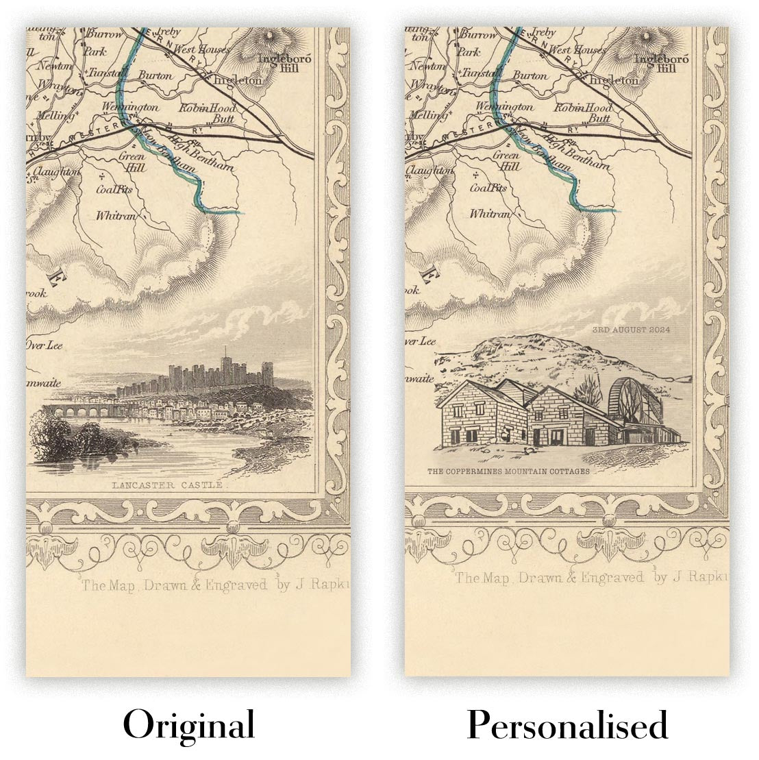
Personalización de mapas
Si está buscando el regalo perfecto de aniversario o inauguración de la casa, puedo personalizar su mapa para hacerlo verdaderamente único. Por ejemplo, puedo agregar un mensaje corto, resaltar una ubicación importante o agregar el escudo de armas de su familia.
Las opciones son casi infinitas. Por favor mira mi página de personalización de mapas para ver algunos maravillosos ejemplos de lo que es posible.
Para pedir un mapa personalizado, seleccione "personalizar su mapa" antes de agregarlo a su carrito.
Ponerse en contacto si buscas personalizaciones y personalizaciones más complejas.
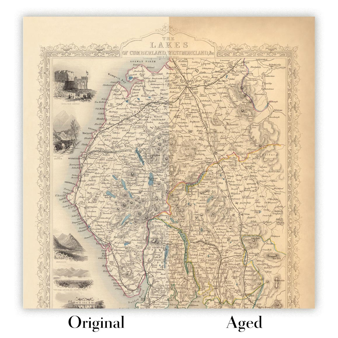
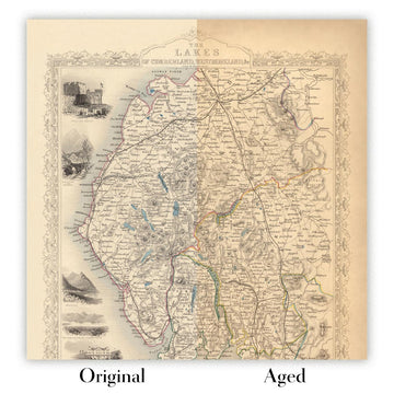
Envejecimiento del mapa
A lo largo de los años, los clientes me han preguntado cientos de veces si podían comprar un mapa que se viera uniforme. más viejo.
Bueno, ahora puedes hacerlo seleccionando Envejecido antes de agregar un mapa a tu carrito.
Todas las fotografías de productos que ve en esta página muestran el mapa en su forma original. Así es como se ve el mapa hoy.
Si selecciona Envejecido, envejeceré su mapa a mano, usando un proceso especial y único desarrollado a través de años de estudiar mapas antiguos, hablar con investigadores para comprender la química del envejecimiento del papel y, por supuesto... ¡mucha práctica!
Si no estás seguro, quédate con el color original del mapa. Si quieres algo un poco más oscuro y más viejo buscando, opte por Envejecido.
Si no estás satisfecho con tu pedido por cualquier motivo, contáctame para un reembolso sin complicaciones. Por favor, consulta nuestra política de devoluciones y reembolsos para más información.
Estoy muy seguro de que te gustará tu mapa o impresión artística restaurada. He estado haciendo esto desde 1984. Soy un vendedor de 5 estrellas en Etsy. He vendido decenas de miles de mapas e impresiones artísticas y tengo más de 5,000 opiniones reales de 5 estrellas.
Utilizo un proceso único para restaurar mapas y obras de arte que consume mucho tiempo y mano de obra. Buscar los mapas e ilustraciones originales puede llevar meses. Utilizo tecnología de última generación y extremadamente cara para escanear y restaurarlos. Como resultado, garantizo que mis mapas e impresiones artísticas son superiores a los demás - por eso puedo ofrecer un reembolso sin complicaciones.
Casi todos mis mapas e impresiones artísticas se ven increíbles en tamaños grandes (200cm, 6.5ft+) y también puedo enmarcarlos y entregártelos a través de un servicio de mensajería especial para tamaños grandes. Contáctame para discutir tus necesidades específicas.
Or try searching for something!


