


Mapa antiguo del Océano Índico y las Indias Orientales de François Valentijn, 1724: rutas comerciales de la VOC neerlandesa, Australia temprana
La oferta del coleccionista
Elija dos obras elegibles y obtenga un 20 % de descuento en ambas. Elija tres y la de menor precio será gratuita, con un ahorro máximo del 33 %.
Combine y mezcle mapas estándar elegibles y reproducciones de bellas artes. No se requiere código; la oferta se aplica automáticamente al finalizar la compra.
Se incluyen las configuraciones estándar hechas por encargo. Quedan excluidos los tamaños a medida, los diseños personalizados y los trabajos por encargo.
¿Necesita entrega en diferentes direcciones? Contáctenos antes de realizar el pedido.La oferta del coleccionista
Elija dos obras elegibles y obtenga un 20 % de descuento en ambas. Elija tres y la de menor precio será gratuita, con un ahorro máximo del 33 %.
Combine y mezcle mapas estándar elegibles y reproducciones de bellas artes. No se requiere código; la oferta se aplica automáticamente al finalizar la compra.
Se incluyen las configuraciones estándar hechas por encargo. Quedan excluidos los tamaños a medida, los diseños personalizados y los trabajos por encargo.
¿Necesita entrega en diferentes direcciones? Contáctenos antes de realizar el pedido. Diseñado en Londres Hecho en Australia
Diseñado en Londres • Hecho en Australia
Diseñado en Londres Hecho en Australia
Diseñado en Londres • Hecho en Australia

Restaurado a partir del mapa original de 1724 e impreso en calidad museo. Leer la historia detrás de este mapa
Choose your size
Choose your finish


(Más información)
Mensaje de regalo y acabado personalizado

Si deseas agregar un mensaje de regalo, o un acabado (rompecabezas, tablero de aluminio, etc.) que no esté disponible aquí, por favor solicítalo en la "nota del pedido" cuando realices la compra.
Cada pedido es hecho a medida, así que si necesitas que el tamaño se ajuste ligeramente, o que se imprima en un material inusual, háznoslo saber. Hemos realizado miles de pedidos personalizados a lo largo de los años, así que hay (casi) nada que no podamos gestionar.
También puedes contactarnos antes de hacer tu pedido, ¡si lo prefieres!

- Hecho localmente. Entrega segura
- Sin aranceles ni cargos ocultos
- ¿Necesitas ayuda? Llámanos o mensaje por WhatsApp
Own a piece of history
8,000+ five-star reviews


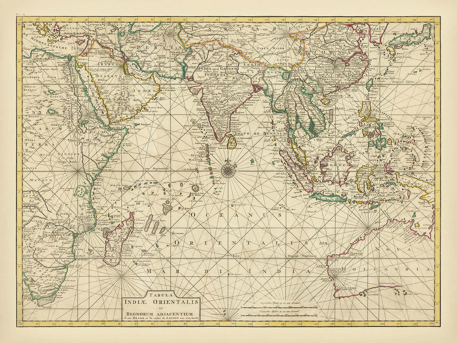
Adéntrese en el mundo de la exploración de comienzos del siglo XVIII con la obra maestra de François Valentijn, "Tabula Indiae Orientalis...
Seguir leyendoAdéntrese en el mundo de la exploración de comienzos del siglo XVIII con la obra maestra de François Valentijn, "Tabula Indiae Orientalis et Regnorum Adjacentium," creada en 1724. Este extraordinario mapa es testimonio de la edad de oro de la cartografía neerlandesa, cuando la Compañía Neerlandesa de las Indias Orientales (VOC) custodiaba celosamente sus secretos de navegación y moldeaba la comprensión del mundo sobre Oriente. Valentijn, ministro, naturalista y prolífico cronista, se encontraba en una posición única para acceder al tesoro de información geográfica de la VOC, que entretejió en este mapa con rigor erudito y talento narrativo. El propio título del mapa evoca la grandeza y el alcance de la visión de Valentijn, capturando la extensión del océano Índico y el rico mosaico de reinos e imperios que bordeaban sus costas.
El alcance geográfico del mapa es sobrecogedor, abarcando el océano Índico, el mar Arábigo, la bahía de Bengala y extendiéndose hacia el este hasta el mar de China Meridional y el mar de Java. El virtuosismo cartográfico de Valentijn se despliega plenamente al representar con meticuloso detalle las costas de África, Arabia, India, el Sudeste Asiático y Australia. Las costas occidental y septentrional de Australia son especialmente significativas, ya que reflejan los descubrimientos pioneros de exploradores de la VOC neerlandesa como Willem Jansz, Dirk Hartog y Pieter Nuyts. Estos contornos, trazados a partir de relatos náuticos de primera mano, representan algunos de los primeros intentos europeos de cartografiar el misterioso continente austral.
El mapa de Valentijn no es meramente un registro de costas e islas; es una vívida crónica de la era de la exploración, el comercio y el encuentro intercultural. El archipiélago indonesio se representa con precisión, reflejando la profunda implicación de la VOC en el comercio de especias y su alcance marítimo sin parangón. Filipinas, representadas en su configuración anterior a 1744, y la forma ambigua de Nueva Guinea hablan de la naturaleza evolutiva del conocimiento geográfico europeo. En el interior, el mapa ofrece una representación inusualmente detallada del sur de la India, basada en la labor pionera del jesuita francés Jean-Venant Bouchet, cuyas mapas manuscritos apenas habían llegado recientemente a Europa.
El arte del mapa se extiende a su densa red de ciudades, puertos y puestos comerciales rotulados, cada uno testimonio de un mundo interconectado del comercio de la Edad Moderna. Elementos notables como la "I. St. Maria" de Madagascar —entonces célebre como refugio de piratas— están señalados con el agudo sentido del cartógrafo tanto del peligro como de la oportunidad. Las costas de China, Corea y Japón se representan con información obtenida de levantamientos jesuitas y marineros de la VOC, revelando un mundo en transformación, moldeado tanto por la ambición europea como por la resiliencia asiática. Ríos, cordilleras y otras características físicas están delicadamente consignados, ofreciendo una ventana a los paisajes que forjaron los destinos de los imperios.
"Tabula Indiae Orientalis et Regnorum Adjacentium" de François Valentijn se alza como un monumento a la curiosidad intelectual y al alcance global de la Edad de Oro neerlandesa. Es un mapa que invita al espectador a seguir las rutas de exploradores, comerciantes y misioneros, y a imaginar el vasto mundo interconectado que ayudaron a crear. Con su combinación de profundidad histórica, precisión cartográfica y riqueza narrativa, este mapa no solo es un tesoro para coleccionistas, sino también un profundo testimonio del esfuerzo humano y el descubrimiento.
Countries and regions on this map
- África (costa oriental)
- Arabia (península arábiga)
- Persia (Irán)
- India (incluido el detallado interior meridional)
- Ceylon (Sri Lanka)
- Maldivas
- Sudeste Asiático (incluyendo Siam/Tailandia, Birmania/Myanmar, Vietnam, Camboya, Laos, Malasia, Indonesia, Filipinas)
- Asia Oriental (China, Corea, Japón)
- Australia (costas occidental y septentrional)
- Madagascar
- Nueva Guinea (parcialmente representada)
Características y monumentos destacados
- Océano Índico
- Mar Arábigo
- Bahía de Bengala
- Mar de China Meridional
- Mar de Java
- Madagascar (incluida "I. St. Maria," un conocido refugio de piratas en la época)
- Maldivas
- Sri Lanka (Ceilán)
- Sumatra, Java, Borneo, Célebes (Sulawesi), Timor y otras islas de Indonesia
- Islas Filipinas
- Partes de Nueva Guinea (forma parcialmente ambigua)
- Costa australiana detallada, rotulada a partir de las exploraciones de la VOC neerlandesa, incluyendo zonas nombradas como "Carpentaria"
- Abundante rotulación de ciudades costeras, puertos y enclaves comerciales
- Rotulación interior detallada del sur de la India que refleja la cartografía pionera de Bouchet de la región del Decán
- Algunos ríos y cordilleras visibles y rotulados, especialmente en la India y el Sudeste Asiático
Contexto histórico y de diseño
- Creado por François Valentijn en 1724, un ministro, naturalista y cronista neerlandés
- Representa uno de los primeros mapas contemporáneos que incorpora conocimiento geográfico detallado de la Compañía Neerlandesa de las Indias Orientales (VOC)
- Valentijn tuvo acceso al archivo de mapas y secretos geográficos de la VOC, anteriormente guardados del público
- Enfatiza la exploración, la navegación marítima, las rutas comerciales coloniales y los descubrimientos geográficos de los exploradores europeos, especialmente de la VOC neerlandesa
- Incluye descubrimientos de exploradores neerlandeses como Willem Jansz, Dirk Hartog y Pieter Nuyts a lo largo de la costa australiana
- Representa el archipiélago indonesio basado en el conocimiento de la VOC, con la forma de Nueva Guinea aún ambigua
- Costas chinas basadas en reconocimientos jesuitas (Martino Martini, décadas de 1640-1650); Corea representada como península; el sur de Japón detallado a partir de cartas de marinos de la VOC
- Detalle avanzado del interior del sur de la India basado en los mapas del jesuita francés Jean-Venant Bouchet
- Detallado y cuidadosamente grabado, típico del estilo cartográfico de principios del siglo XVIII, con una clara rotulación de elementos costeros, islas y lugares interiores destacados
- La erudición de Valentijn fue amplia, pero se sabe que tomó prestado en gran medida de otras fuentes, reflejando los estándares del siglo XVIII en materia de referencia y originalidad
Por favor, compruebe las imágenes para asegurarse de que una ciudad o lugar concreto aparezca en este mapa. También puede ponerse en contacto con nosotros y pedirnos que revisemos el mapa por usted.
Este mapa luce magnífico en cualquier tamaño, pero siempre recomiendo optar por un tamaño mayor si tiene espacio. Así podrá distinguir fácilmente todos los detalles.
Este mapa luce increíble en tamaños de hasta 100in (250cm). Si busca un mapa de mayor tamaño, por favor póngase en contacto.
La persona del modelo en las imágenes del anuncio sostiene la versión de 18x24in (45x60cm) de este mapa.
La quinta imagen del anuncio muestra un ejemplo de mi servicio de personalización de mapas.
Si busca algo un poco diferente, eche un vistazo a mi colección de los mejores mapas antiguos para ver si algo más le llama la atención.
Por favor, contácteme para comprobar si una determinada ubicación, monumento o elemento aparece en este mapa.
Sería un regalo maravilloso de cumpleaños, Navidad, Día del Padre, despedida de trabajo, aniversario o inauguración de casa para alguien de las zonas cubiertas por este mapa.
Este mapa está disponible como impresión giclée en papel mate de archivo libre de ácido, o puede adquirirse enmarcado. El marco es un marco negro, sencillo y elegante, que se adapta a la mayoría de las estéticas. Póngase en contacto si desea un color o material de marco diferente. Mis marcos llevan acristalamiento con acrílico de calidad museística, supertransparente (perspex/acrylite), que es considerablemente menos reflectante que el vidrio, más seguro y llegará siempre en perfectas condiciones.
This map is also available as a float framed canvas, sometimes known as a shadow gap framed canvas or canvas floater. The map is printed on artist's cotton canvas and then stretched over a handmade box frame. We then "float" the canvas inside a wooden frame, which is available in a range of colours (black, dark brown, oak, antique gold and white). This is a wonderful way to present a map without glazing in front. See some examples of float framed canvas maps and explore the differences between my different finishes.
For something truly unique, this map is also available in "Unique 3D", our trademarked process that dramatically transforms the map so that it has a wonderful sense of depth. We combine the original map with detailed topography and elevation data, so that mountains and the terrain really "pop". For more info and examples of 3D maps, check my Unique 3D page.
Adéntrese en el mundo de la exploración de comienzos del siglo XVIII con la obra maestra de François Valentijn, "Tabula Indiae Orientalis et Regnorum Adjacentium," creada en 1724. Este extraordinario mapa es testimonio de la edad de oro de la cartografía neerlandesa, cuando la Compañía Neerlandesa de las Indias Orientales (VOC) custodiaba celosamente sus secretos de navegación y moldeaba la comprensión del mundo sobre Oriente. Valentijn, ministro, naturalista y prolífico cronista, se encontraba en una posición única para acceder al tesoro de información geográfica de la VOC, que entretejió en este mapa con rigor erudito y talento narrativo. El propio título del mapa evoca la grandeza y el alcance de la visión de Valentijn, capturando la extensión del océano Índico y el rico mosaico de reinos e imperios que bordeaban sus costas.
El alcance geográfico del mapa es sobrecogedor, abarcando el océano Índico, el mar Arábigo, la bahía de Bengala y extendiéndose hacia el este hasta el mar de China Meridional y el mar de Java. El virtuosismo cartográfico de Valentijn se despliega plenamente al representar con meticuloso detalle las costas de África, Arabia, India, el Sudeste Asiático y Australia. Las costas occidental y septentrional de Australia son especialmente significativas, ya que reflejan los descubrimientos pioneros de exploradores de la VOC neerlandesa como Willem Jansz, Dirk Hartog y Pieter Nuyts. Estos contornos, trazados a partir de relatos náuticos de primera mano, representan algunos de los primeros intentos europeos de cartografiar el misterioso continente austral.
El mapa de Valentijn no es meramente un registro de costas e islas; es una vívida crónica de la era de la exploración, el comercio y el encuentro intercultural. El archipiélago indonesio se representa con precisión, reflejando la profunda implicación de la VOC en el comercio de especias y su alcance marítimo sin parangón. Filipinas, representadas en su configuración anterior a 1744, y la forma ambigua de Nueva Guinea hablan de la naturaleza evolutiva del conocimiento geográfico europeo. En el interior, el mapa ofrece una representación inusualmente detallada del sur de la India, basada en la labor pionera del jesuita francés Jean-Venant Bouchet, cuyas mapas manuscritos apenas habían llegado recientemente a Europa.
El arte del mapa se extiende a su densa red de ciudades, puertos y puestos comerciales rotulados, cada uno testimonio de un mundo interconectado del comercio de la Edad Moderna. Elementos notables como la "I. St. Maria" de Madagascar —entonces célebre como refugio de piratas— están señalados con el agudo sentido del cartógrafo tanto del peligro como de la oportunidad. Las costas de China, Corea y Japón se representan con información obtenida de levantamientos jesuitas y marineros de la VOC, revelando un mundo en transformación, moldeado tanto por la ambición europea como por la resiliencia asiática. Ríos, cordilleras y otras características físicas están delicadamente consignados, ofreciendo una ventana a los paisajes que forjaron los destinos de los imperios.
"Tabula Indiae Orientalis et Regnorum Adjacentium" de François Valentijn se alza como un monumento a la curiosidad intelectual y al alcance global de la Edad de Oro neerlandesa. Es un mapa que invita al espectador a seguir las rutas de exploradores, comerciantes y misioneros, y a imaginar el vasto mundo interconectado que ayudaron a crear. Con su combinación de profundidad histórica, precisión cartográfica y riqueza narrativa, este mapa no solo es un tesoro para coleccionistas, sino también un profundo testimonio del esfuerzo humano y el descubrimiento.
Countries and regions on this map
- África (costa oriental)
- Arabia (península arábiga)
- Persia (Irán)
- India (incluido el detallado interior meridional)
- Ceylon (Sri Lanka)
- Maldivas
- Sudeste Asiático (incluyendo Siam/Tailandia, Birmania/Myanmar, Vietnam, Camboya, Laos, Malasia, Indonesia, Filipinas)
- Asia Oriental (China, Corea, Japón)
- Australia (costas occidental y septentrional)
- Madagascar
- Nueva Guinea (parcialmente representada)
Características y monumentos destacados
- Océano Índico
- Mar Arábigo
- Bahía de Bengala
- Mar de China Meridional
- Mar de Java
- Madagascar (incluida "I. St. Maria," un conocido refugio de piratas en la época)
- Maldivas
- Sri Lanka (Ceilán)
- Sumatra, Java, Borneo, Célebes (Sulawesi), Timor y otras islas de Indonesia
- Islas Filipinas
- Partes de Nueva Guinea (forma parcialmente ambigua)
- Costa australiana detallada, rotulada a partir de las exploraciones de la VOC neerlandesa, incluyendo zonas nombradas como "Carpentaria"
- Abundante rotulación de ciudades costeras, puertos y enclaves comerciales
- Rotulación interior detallada del sur de la India que refleja la cartografía pionera de Bouchet de la región del Decán
- Algunos ríos y cordilleras visibles y rotulados, especialmente en la India y el Sudeste Asiático
Contexto histórico y de diseño
- Creado por François Valentijn en 1724, un ministro, naturalista y cronista neerlandés
- Representa uno de los primeros mapas contemporáneos que incorpora conocimiento geográfico detallado de la Compañía Neerlandesa de las Indias Orientales (VOC)
- Valentijn tuvo acceso al archivo de mapas y secretos geográficos de la VOC, anteriormente guardados del público
- Enfatiza la exploración, la navegación marítima, las rutas comerciales coloniales y los descubrimientos geográficos de los exploradores europeos, especialmente de la VOC neerlandesa
- Incluye descubrimientos de exploradores neerlandeses como Willem Jansz, Dirk Hartog y Pieter Nuyts a lo largo de la costa australiana
- Representa el archipiélago indonesio basado en el conocimiento de la VOC, con la forma de Nueva Guinea aún ambigua
- Costas chinas basadas en reconocimientos jesuitas (Martino Martini, décadas de 1640-1650); Corea representada como península; el sur de Japón detallado a partir de cartas de marinos de la VOC
- Detalle avanzado del interior del sur de la India basado en los mapas del jesuita francés Jean-Venant Bouchet
- Detallado y cuidadosamente grabado, típico del estilo cartográfico de principios del siglo XVIII, con una clara rotulación de elementos costeros, islas y lugares interiores destacados
- La erudición de Valentijn fue amplia, pero se sabe que tomó prestado en gran medida de otras fuentes, reflejando los estándares del siglo XVIII en materia de referencia y originalidad
Por favor, compruebe las imágenes para asegurarse de que una ciudad o lugar concreto aparezca en este mapa. También puede ponerse en contacto con nosotros y pedirnos que revisemos el mapa por usted.
Este mapa luce magnífico en cualquier tamaño, pero siempre recomiendo optar por un tamaño mayor si tiene espacio. Así podrá distinguir fácilmente todos los detalles.
Este mapa luce increíble en tamaños de hasta 100in (250cm). Si busca un mapa de mayor tamaño, por favor póngase en contacto.
La persona del modelo en las imágenes del anuncio sostiene la versión de 18x24in (45x60cm) de este mapa.
La quinta imagen del anuncio muestra un ejemplo de mi servicio de personalización de mapas.
Si busca algo un poco diferente, eche un vistazo a mi colección de los mejores mapas antiguos para ver si algo más le llama la atención.
Por favor, contácteme para comprobar si una determinada ubicación, monumento o elemento aparece en este mapa.
Sería un regalo maravilloso de cumpleaños, Navidad, Día del Padre, despedida de trabajo, aniversario o inauguración de casa para alguien de las zonas cubiertas por este mapa.
Este mapa está disponible como impresión giclée en papel mate de archivo libre de ácido, o puede adquirirse enmarcado. El marco es un marco negro, sencillo y elegante, que se adapta a la mayoría de las estéticas. Póngase en contacto si desea un color o material de marco diferente. Mis marcos llevan acristalamiento con acrílico de calidad museística, supertransparente (perspex/acrylite), que es considerablemente menos reflectante que el vidrio, más seguro y llegará siempre en perfectas condiciones.
This map is also available as a float framed canvas, sometimes known as a shadow gap framed canvas or canvas floater. The map is printed on artist's cotton canvas and then stretched over a handmade box frame. We then "float" the canvas inside a wooden frame, which is available in a range of colours (black, dark brown, oak, antique gold and white). This is a wonderful way to present a map without glazing in front. See some examples of float framed canvas maps and explore the differences between my different finishes.
For something truly unique, this map is also available in "Unique 3D", our trademarked process that dramatically transforms the map so that it has a wonderful sense of depth. We combine the original map with detailed topography and elevation data, so that mountains and the terrain really "pop". For more info and examples of 3D maps, check my Unique 3D page.
Many of our maps and art prints are chosen as thoughtful gifts for homes, offices, studies and meaningful places.
Choose a framed option for the easiest ready-to-hang gift, or choose an unframed print if the recipient may prefer to select their own frame.
We make orders locally in 23 countries around the world, so gifts can often be produced close to the recipient. This helps them arrive faster, travel more safely, and avoid customs or import duty surprises.
- We can deliver directly to the recipient
- Framed pieces arrive ready to hang
- Unframed prints are carefully packed in a strong protective tube
- Almost every order is made locally, for faster, safer gifting
- 90-day returns give the recipient time to decide
If you are not sure what to choose, please contact us. We can help you pick the right map, size, finish or delivery option.
Para la mayoría de los pedidos, el tiempo de entrega es de aproximadamente 3 días laborables. Los productos personalizados y a medida tardan más, ya que tengo que hacer la personalización y enviártelo para su aprobación, lo cual suele tardar 1 o 2 días.
Tenga en cuenta que los pedidos enmarcados muy grandes suelen tardar más en fabricarse y entregarse.
Si necesitas que tu pedido llegue para una fecha determinada, por favor contáctame antes de hacer el pedido para que podamos encontrar la mejor manera de asegurarnos de que recibas tu pedido a tiempo.
Imprimo y enmarco mapas y obras de arte en 23 países alrededor del mundo. Esto significa que tu pedido se fabricará localmente, lo que reduce el tiempo de entrega y asegura que no se dañe durante el envío. Nunca pagarás aranceles de aduana o impuestos de importación, y pondremos menos CO2 en el aire.
Todos mis mapas y impresiones artísticas están bien empaquetados y enviados en un tubo resistente si no están enmarcados, o rodeados de espuma si están enmarcados.
Intento enviar todos los pedidos dentro de 1 o 2 días después de recibir tu pedido, aunque algunos productos (como mascarillas, tazas y bolsas de tela) pueden tardar más en fabricarse.
Si seleccionas Entrega Exprés al finalizar la compra, priorizaremos tu pedido y lo enviaremos por mensajería de 1 día (Fedex, DHL, UPS, Parcelforce).
La entrega al día siguiente también está disponible en algunos países (EE. UU., Reino Unido, Singapur, EAU), pero por favor intenta hacer tu pedido temprano en el día para que podamos enviarlo a tiempo.
Mi marco estándar es un marco de madera de fresno negro estilo galería. Es simple y tiene un aspecto bastante moderno. Mi marco estándar tiene alrededor de 20 mm (0.8 in) de ancho.
Utilizo acrílico super claro (perspex/acrylite) para el vidrio del marco. Es más ligero y seguro que el vidrio, y se ve mejor, ya que la reflectividad es menor.
Seis colores de marco estándar están disponibles de forma gratuita (negro, marrón oscuro, gris oscuro, roble, blanco y oro antiguo).El enmarcado y montaje/matizado personalizado está disponible si buscas algo diferente.
La mayoría de los mapas, arte e ilustraciones también están disponibles como un lienzo enmarcado. Utilizamos lienzo de algodón mate (no brillante), lo estiramos sobre un marco de madera de caja de origen sostenible, y luego 'flotamos' la pieza dentro de un marco de madera. El resultado final es bastante hermoso, y no hay cristal que se interponga.
Todos los marcos se proporcionan "listos para colgar", con una cuerda o soportes en la parte posterior. Los marcos muy grandes tendrán placas de colgar de alta resistencia y/o un listón de montaje. Si tienes alguna pregunta, por favor ponte en contacto.
Mira algunos ejemplos de mis mapas enmarcados y mapas en lienzo enmarcados.
Alternativamente, también puedo proporcionar mapas antiguos y obras de arte en lienzo, tablero de espuma, papel de algodón y otros materiales.
Si deseas enmarcar tu mapa o obra de arte tú mismo, por favor lee mi guía de tamaños primero.
Mis mapas son reproducciones de mapas originales de altísima calidad.
Obtengo mapas originales y raros de bibliotecas, casas de subastas y colecciones privadas de todo el mundo, los restauro en mi taller de Londres y luego uso tintas e impresoras giclée especializadas para crear hermosos mapas que lucen incluso mejor que el original.
Mis mapas están impresos en papel de archivo mate (no brillante) sin ácido que se siente de muy alta calidad y casi como una tarjeta. En términos técnicos, el peso/grosor del papel es de 10 mil/200 g/m². Es perfecto para enmarcar.
Imprimo con tintas pigmentadas Epson ultrachrome giclée UV resistentes a la decoloración, algunas de las mejores tintas que puedes encontrar.
yo también puedo hacer mapas sobre lienzo, trapo de algodón y otros materiales exóticos.
Obtenga más información sobre The Unique Maps Co..
Personalización de mapas
Si está buscando el regalo perfecto de aniversario o inauguración de la casa, puedo personalizar su mapa para hacerlo verdaderamente único. Por ejemplo, puedo agregar un mensaje corto, resaltar una ubicación importante o agregar el escudo de armas de su familia.
Las opciones son casi infinitas. Por favor mira mi página de personalización de mapas para ver algunos maravillosos ejemplos de lo que es posible.
Para pedir un mapa personalizado, seleccione "personalizar su mapa" antes de agregarlo a su carrito.
Ponerse en contacto si buscas personalizaciones y personalizaciones más complejas.
Envejecimiento del mapa
A lo largo de los años, los clientes me han preguntado cientos de veces si podían comprar un mapa que se viera uniforme. más viejo.
Bueno, ahora puedes hacerlo seleccionando Envejecido antes de agregar un mapa a tu carrito.
Todas las fotografías de productos que ve en esta página muestran el mapa en su forma original. Así es como se ve el mapa hoy.
Si selecciona Envejecido, envejeceré su mapa a mano, usando un proceso especial y único desarrollado a través de años de estudiar mapas antiguos, hablar con investigadores para comprender la química del envejecimiento del papel y, por supuesto... ¡mucha práctica!
Si no estás seguro, quédate con el color original del mapa. Si quieres algo un poco más oscuro y más viejo buscando, opte por Envejecido.
Si no estás satisfecho con tu pedido por cualquier motivo, contáctame para un reembolso sin complicaciones. Por favor, consulta nuestra política de devoluciones y reembolsos para más información.
Estoy muy seguro de que te gustará tu mapa o impresión artística restaurada. He estado haciendo esto desde 1984. Soy un vendedor de 5 estrellas en Etsy. He vendido decenas de miles de mapas e impresiones artísticas y tengo más de 5,000 opiniones reales de 5 estrellas.
Utilizo un proceso único para restaurar mapas y obras de arte que consume mucho tiempo y mano de obra. Buscar los mapas e ilustraciones originales puede llevar meses. Utilizo tecnología de última generación y extremadamente cara para escanear y restaurarlos. Como resultado, garantizo que mis mapas e impresiones artísticas son superiores a los demás - por eso puedo ofrecer un reembolso sin complicaciones.
Casi todos mis mapas e impresiones artísticas se ven increíbles en tamaños grandes (200cm, 6.5ft+) y también puedo enmarcarlos y entregártelos a través de un servicio de mensajería especial para tamaños grandes. Contáctame para discutir tus necesidades específicas.
Or try searching for something!


