


Mapa pictórico de Maine de Ruth Taylor White, 1935: Portland, Bangor, madera, pesca de langosta, Katahdin
La oferta del coleccionista
Elija dos obras elegibles y obtenga un 20 % de descuento en ambas. Elija tres y la de menor precio será gratuita, con un ahorro máximo del 33 %.
Combine y mezcle mapas estándar elegibles y reproducciones de bellas artes. No se requiere código; la oferta se aplica automáticamente al finalizar la compra.
Se incluyen las configuraciones estándar hechas por encargo. Quedan excluidos los tamaños a medida, los diseños personalizados y los trabajos por encargo.
¿Necesita entrega en diferentes direcciones? Contáctenos antes de realizar el pedido.La oferta del coleccionista
Elija dos obras elegibles y obtenga un 20 % de descuento en ambas. Elija tres y la de menor precio será gratuita, con un ahorro máximo del 33 %.
Combine y mezcle mapas estándar elegibles y reproducciones de bellas artes. No se requiere código; la oferta se aplica automáticamente al finalizar la compra.
Se incluyen las configuraciones estándar hechas por encargo. Quedan excluidos los tamaños a medida, los diseños personalizados y los trabajos por encargo.
¿Necesita entrega en diferentes direcciones? Contáctenos antes de realizar el pedido. Diseñado en Londres Hecho en Australia
Diseñado en Londres • Hecho en Australia
Diseñado en Londres Hecho en Australia
Diseñado en Londres • Hecho en Australia

Restaurado a partir del mapa original de 1935 e impreso en calidad museo. Leer la historia detrás de este mapa
Choose your size
Choose your finish


(Más información)
Mensaje de regalo y acabado personalizado

Si deseas agregar un mensaje de regalo, o un acabado (rompecabezas, tablero de aluminio, etc.) que no esté disponible aquí, por favor solicítalo en la "nota del pedido" cuando realices la compra.
Cada pedido es hecho a medida, así que si necesitas que el tamaño se ajuste ligeramente, o que se imprima en un material inusual, háznoslo saber. Hemos realizado miles de pedidos personalizados a lo largo de los años, así que hay (casi) nada que no podamos gestionar.
También puedes contactarnos antes de hacer tu pedido, ¡si lo prefieres!

- Hecho localmente. Entrega segura
- Sin aranceles ni cargos ocultos
- ¿Necesitas ayuda? Llámanos o mensaje por WhatsApp
Own a piece of history
8,000+ five-star reviews


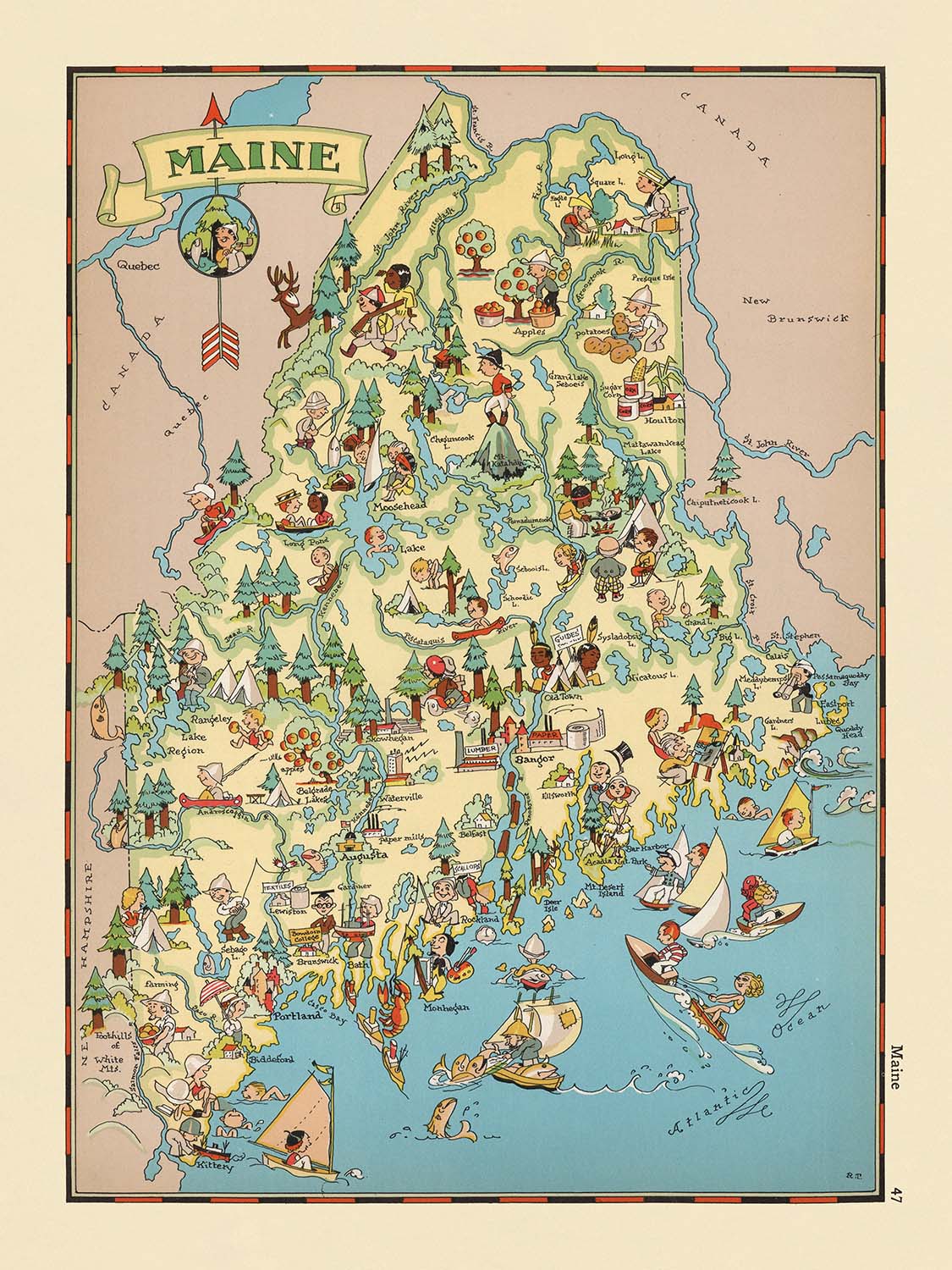
Adéntrese en el mundo caprichoso de la América de los años 30 con "Maine", el título original de este encantador mapa pictórico...
Seguir leyendoAdéntrese en el mundo caprichoso de la América de los años 30 con "Maine", el título original de este encantador mapa pictórico creado por Ruth Taylor White en 1935. Esta cautivadora pieza cartográfica es un testimonio de una época pasada, cuando la elaboración de mapas se ocupaba tanto de contar historias y de la expresión artística como de la navegación. El mapa es una vibrante celebración de la identidad única de Maine, cobrada vida a través de un encantador conjunto de ilustraciones coloridas que capturan el espíritu y el carácter del Estado del Pino. Desde sus bulliciosos pueblos costeros hasta sus tranquilosos bosques, cada centímetro del estado está representado con un detalle lúdico, convirtiendo este mapa en un festín visual tanto para coleccionistas como para amantes de la historia.
Ruth Taylor White, la fuerza creativa detrás de este mapa, fue reconocida por su enfoque distintivo de la cartografía durante comienzos del siglo XX. Su obra, a menudo publicada en colaboración con Frank J. Taylor, es inmediatamente reconocible por su estilo vivaz, de aire caricaturesco, y por su representación afectuosa de las particularidades y costumbres regionales. Los mapas de White no son meros registros geográficos; son ventanas al corazón cultural de cada estado, combinando la precisión factual con el encanto del arte popular. Su mapa de Maine, en particular, destaca por su capacidad para condensar la esencia del estado en un único y atractivo cuadro que invita a la exploración y el descubrimiento.
El diseño del mapa es una lección magistral de cartografía temática y pictórica. Los límites de los condados están claramente delimitados, mientras que las características más significativas del estado cobran vida mediante ilustraciones caprichosas. Leñadores trabajan en los vastos bosques del norte, en alusión a la célebre industria maderera de Maine, mientras que pescadores y recolectores de langostas faenan a lo largo de la escarpada costa atlántica, destacando la perdurable importancia de la vida marítima. Los fértiles campos del condado de Aroostook se celebran con imágenes del cultivo de la patata, y la riqueza natural del estado se exhibe además con representaciones de arándanos, alces y densos bosques. Cada ilustración sirve tanto como punto de referencia educativo como celebración de los diversos paisajes de Maine.
Una mirada más atenta revela la cuidada atención del mapa a la geografía humana de Maine. Ciudades y localidades principales como Portland, Lewiston, Bangor y Augusta aparecen de forma destacada, subrayándose su importancia actual mediante su inclusión. Estos núcleos se encuentran enclavados entre referencias visuales a las montañas, ríos y emblemáticos faros del estado, todo ello sobre el telón de fondo del océano Atlántico. La ausencia de referencias explícitas a parques nacionales se compensa con evocadoras representaciones de los espacios salvajes de Maine, como el área general del monte Katahdin, invitando al espectador a imaginar las aventuras que aguardan en estas regiones indómitas.
Desde una perspectiva histórica, este mapa es un fascinante artefacto de la era de la Gran Depresión, que refleja el optimismo y el orgullo regional que caracterizaron la cultura estadounidense durante la década de 1930. Su estilo lúdico y sus estereotipos afectuosos ofrecen una ventana a las actitudes de la época, mientras que su meticulosa ejecución garantiza su atractivo perdurable. Ya sea exhibido como pieza central en una colección curada o apreciado por su valor artístico e histórico, "Maine" de Ruth Taylor White es más que un mapa: es una vibrante narración de un estado y su gente, plasmada con calidez, ingenio y una destreza extraordinaria.
Cities and towns on this map
- Portland
- Lewiston
- Bangor
- South Portland
- Auburn
- Biddeford
- Sanford
- Augusta
- Saco
- Westbrook
- Waterville
- Presque Isle
- Brewer
- Bath
- Caribou
- Old Town
- Rockland
- Ellsworth
- Belfast
- Gardiner
Características destacadas y lugares de interés
- Ilustraciones coloridas de leñadores y actividades de tala, destacando la histórica industria maderera de Maine
- Representaciones de la pesca y la captura de langostas a lo largo de la costa, enfatizando la economía marítima de Maine
- Ilustraciones de patatas y del cultivo de patatas, en referencia a la importancia agrícola del condado de Aroostook
- Imágenes de alces y otra fauna silvestre, representando el entorno natural de Maine
- Escenas costeras con barcos y faros, ilustrando la escarpada línea de costa del estado
- Representación de actividades recreativas como el esquí y el piragüismo
- Representación visual de los arándanos, otro cultivo clave de Maine
- Representaciones artísticas de bosques y montañas, incluida la zona general del monte Katahdin (no señalada específicamente)
- Los límites de los condados están delineados y etiquetados
- El océano Atlántico está señalado a lo largo del borde sur y este del estado
Contexto histórico y de diseño
- Título original: "Maine"
- Creado por Ruth Taylor White en 1935
- Publicado en colaboración con Frank J. Taylor
- Mapa temático y pictórico de condado o estado
- Ilustraciones caprichosas, coloridas y de estilo caricaturesco, típicas de los mapas pictóricos de Ruth Taylor White de la década de 1930
- Parte de un atlas pictórico más amplio de Estados Unidos, conocido por sus representaciones entretenidas y fantásticas de cada estado
- Ofrece una narrativa visual de la cultura, geografía y economía de Maine mediante un arte lúdico
- Históricamente significativo como ejemplo de la cartografía pictórica estadounidense de la época de la Depresión, reflejando actitudes y estereotipos contemporáneos
- Popular entre coleccionistas y aficionados a la Americana y a los mapas históricos
Por favor, revise cuidadosamente las imágenes para asegurarse de que una ciudad o lugar específico aparezca en este mapa. También puede ponerse en contacto con nosotros y pedirnos que comprobemos el mapa por usted.
Este mapa luce magnífico en cualquier tamaño, pero siempre recomiendo optar por un tamaño mayor si dispone de espacio. Así podrá distinguir fácilmente todos los detalles.
Este mapa se ve increíble en tamaños de hasta 50in (125cm). Si está buscando un mapa más grande, por favor póngase en contacto.
El modelo en las imágenes del anuncio está sosteniendo la versión de 18x24in (45x60cm) de este mapa.
La quinta imagen del anuncio muestra un ejemplo de mi servicio de personalización de mapas.
Si busca algo un poco diferente, eche un vistazo a mi colección de los mejores mapas antiguos para ver si algo más llama su atención.
Por favor, contácteme para comprobar si en este mapa aparece una determinada ubicación, lugar de interés o elemento destacado.
Sería un regalo maravilloso de cumpleaños, Navidad, Día del Padre, despedida del trabajo, aniversario o inauguración de casa para alguien de las zonas cubiertas por este mapa.
Este mapa está disponible como impresión giclée sobre papel mate de archivo libre de ácido, o puede adquirirlo enmarcado. El marco es un marco negro sencillo y elegante que se adapta a la mayoría de los estilos decorativos. Póngase en contacto si desea un color o material de marco diferente. Mis marcos están acristalados con acrílico de grado museo supertransparente (plexiglás/acrilito), que es significativamente menos reflectante que el vidrio, más seguro y siempre llegará en perfecto estado.
This map is also available as a float framed canvas, sometimes known as a shadow gap framed canvas or canvas floater. The map is printed on artist's cotton canvas and then stretched over a handmade box frame. We then "float" the canvas inside a wooden frame, which is available in a range of colours (black, dark brown, oak, antique gold and white). This is a wonderful way to present a map without glazing in front. See some examples of float framed canvas maps and explore the differences between my different finishes.
For something truly unique, this map is also available in "Unique 3D", our trademarked process that dramatically transforms the map so that it has a wonderful sense of depth. We combine the original map with detailed topography and elevation data, so that mountains and the terrain really "pop". For more info and examples of 3D maps, check my Unique 3D page.
Adéntrese en el mundo caprichoso de la América de los años 30 con "Maine", el título original de este encantador mapa pictórico creado por Ruth Taylor White en 1935. Esta cautivadora pieza cartográfica es un testimonio de una época pasada, cuando la elaboración de mapas se ocupaba tanto de contar historias y de la expresión artística como de la navegación. El mapa es una vibrante celebración de la identidad única de Maine, cobrada vida a través de un encantador conjunto de ilustraciones coloridas que capturan el espíritu y el carácter del Estado del Pino. Desde sus bulliciosos pueblos costeros hasta sus tranquilosos bosques, cada centímetro del estado está representado con un detalle lúdico, convirtiendo este mapa en un festín visual tanto para coleccionistas como para amantes de la historia.
Ruth Taylor White, la fuerza creativa detrás de este mapa, fue reconocida por su enfoque distintivo de la cartografía durante comienzos del siglo XX. Su obra, a menudo publicada en colaboración con Frank J. Taylor, es inmediatamente reconocible por su estilo vivaz, de aire caricaturesco, y por su representación afectuosa de las particularidades y costumbres regionales. Los mapas de White no son meros registros geográficos; son ventanas al corazón cultural de cada estado, combinando la precisión factual con el encanto del arte popular. Su mapa de Maine, en particular, destaca por su capacidad para condensar la esencia del estado en un único y atractivo cuadro que invita a la exploración y el descubrimiento.
El diseño del mapa es una lección magistral de cartografía temática y pictórica. Los límites de los condados están claramente delimitados, mientras que las características más significativas del estado cobran vida mediante ilustraciones caprichosas. Leñadores trabajan en los vastos bosques del norte, en alusión a la célebre industria maderera de Maine, mientras que pescadores y recolectores de langostas faenan a lo largo de la escarpada costa atlántica, destacando la perdurable importancia de la vida marítima. Los fértiles campos del condado de Aroostook se celebran con imágenes del cultivo de la patata, y la riqueza natural del estado se exhibe además con representaciones de arándanos, alces y densos bosques. Cada ilustración sirve tanto como punto de referencia educativo como celebración de los diversos paisajes de Maine.
Una mirada más atenta revela la cuidada atención del mapa a la geografía humana de Maine. Ciudades y localidades principales como Portland, Lewiston, Bangor y Augusta aparecen de forma destacada, subrayándose su importancia actual mediante su inclusión. Estos núcleos se encuentran enclavados entre referencias visuales a las montañas, ríos y emblemáticos faros del estado, todo ello sobre el telón de fondo del océano Atlántico. La ausencia de referencias explícitas a parques nacionales se compensa con evocadoras representaciones de los espacios salvajes de Maine, como el área general del monte Katahdin, invitando al espectador a imaginar las aventuras que aguardan en estas regiones indómitas.
Desde una perspectiva histórica, este mapa es un fascinante artefacto de la era de la Gran Depresión, que refleja el optimismo y el orgullo regional que caracterizaron la cultura estadounidense durante la década de 1930. Su estilo lúdico y sus estereotipos afectuosos ofrecen una ventana a las actitudes de la época, mientras que su meticulosa ejecución garantiza su atractivo perdurable. Ya sea exhibido como pieza central en una colección curada o apreciado por su valor artístico e histórico, "Maine" de Ruth Taylor White es más que un mapa: es una vibrante narración de un estado y su gente, plasmada con calidez, ingenio y una destreza extraordinaria.
Cities and towns on this map
- Portland
- Lewiston
- Bangor
- South Portland
- Auburn
- Biddeford
- Sanford
- Augusta
- Saco
- Westbrook
- Waterville
- Presque Isle
- Brewer
- Bath
- Caribou
- Old Town
- Rockland
- Ellsworth
- Belfast
- Gardiner
Características destacadas y lugares de interés
- Ilustraciones coloridas de leñadores y actividades de tala, destacando la histórica industria maderera de Maine
- Representaciones de la pesca y la captura de langostas a lo largo de la costa, enfatizando la economía marítima de Maine
- Ilustraciones de patatas y del cultivo de patatas, en referencia a la importancia agrícola del condado de Aroostook
- Imágenes de alces y otra fauna silvestre, representando el entorno natural de Maine
- Escenas costeras con barcos y faros, ilustrando la escarpada línea de costa del estado
- Representación de actividades recreativas como el esquí y el piragüismo
- Representación visual de los arándanos, otro cultivo clave de Maine
- Representaciones artísticas de bosques y montañas, incluida la zona general del monte Katahdin (no señalada específicamente)
- Los límites de los condados están delineados y etiquetados
- El océano Atlántico está señalado a lo largo del borde sur y este del estado
Contexto histórico y de diseño
- Título original: "Maine"
- Creado por Ruth Taylor White en 1935
- Publicado en colaboración con Frank J. Taylor
- Mapa temático y pictórico de condado o estado
- Ilustraciones caprichosas, coloridas y de estilo caricaturesco, típicas de los mapas pictóricos de Ruth Taylor White de la década de 1930
- Parte de un atlas pictórico más amplio de Estados Unidos, conocido por sus representaciones entretenidas y fantásticas de cada estado
- Ofrece una narrativa visual de la cultura, geografía y economía de Maine mediante un arte lúdico
- Históricamente significativo como ejemplo de la cartografía pictórica estadounidense de la época de la Depresión, reflejando actitudes y estereotipos contemporáneos
- Popular entre coleccionistas y aficionados a la Americana y a los mapas históricos
Por favor, revise cuidadosamente las imágenes para asegurarse de que una ciudad o lugar específico aparezca en este mapa. También puede ponerse en contacto con nosotros y pedirnos que comprobemos el mapa por usted.
Este mapa luce magnífico en cualquier tamaño, pero siempre recomiendo optar por un tamaño mayor si dispone de espacio. Así podrá distinguir fácilmente todos los detalles.
Este mapa se ve increíble en tamaños de hasta 50in (125cm). Si está buscando un mapa más grande, por favor póngase en contacto.
El modelo en las imágenes del anuncio está sosteniendo la versión de 18x24in (45x60cm) de este mapa.
La quinta imagen del anuncio muestra un ejemplo de mi servicio de personalización de mapas.
Si busca algo un poco diferente, eche un vistazo a mi colección de los mejores mapas antiguos para ver si algo más llama su atención.
Por favor, contácteme para comprobar si en este mapa aparece una determinada ubicación, lugar de interés o elemento destacado.
Sería un regalo maravilloso de cumpleaños, Navidad, Día del Padre, despedida del trabajo, aniversario o inauguración de casa para alguien de las zonas cubiertas por este mapa.
Este mapa está disponible como impresión giclée sobre papel mate de archivo libre de ácido, o puede adquirirlo enmarcado. El marco es un marco negro sencillo y elegante que se adapta a la mayoría de los estilos decorativos. Póngase en contacto si desea un color o material de marco diferente. Mis marcos están acristalados con acrílico de grado museo supertransparente (plexiglás/acrilito), que es significativamente menos reflectante que el vidrio, más seguro y siempre llegará en perfecto estado.
This map is also available as a float framed canvas, sometimes known as a shadow gap framed canvas or canvas floater. The map is printed on artist's cotton canvas and then stretched over a handmade box frame. We then "float" the canvas inside a wooden frame, which is available in a range of colours (black, dark brown, oak, antique gold and white). This is a wonderful way to present a map without glazing in front. See some examples of float framed canvas maps and explore the differences between my different finishes.
For something truly unique, this map is also available in "Unique 3D", our trademarked process that dramatically transforms the map so that it has a wonderful sense of depth. We combine the original map with detailed topography and elevation data, so that mountains and the terrain really "pop". For more info and examples of 3D maps, check my Unique 3D page.
Many of our maps and art prints are chosen as thoughtful gifts for homes, offices, studies and meaningful places.
Choose a framed option for the easiest ready-to-hang gift, or choose an unframed print if the recipient may prefer to select their own frame.
We make orders locally in 23 countries around the world, so gifts can often be produced close to the recipient. This helps them arrive faster, travel more safely, and avoid customs or import duty surprises.
- We can deliver directly to the recipient
- Framed pieces arrive ready to hang
- Unframed prints are carefully packed in a strong protective tube
- Almost every order is made locally, for faster, safer gifting
- 90-day returns give the recipient time to decide
If you are not sure what to choose, please contact us. We can help you pick the right map, size, finish or delivery option.
Para la mayoría de los pedidos, el tiempo de entrega es de aproximadamente 3 días laborables. Los productos personalizados y a medida tardan más, ya que tengo que hacer la personalización y enviártelo para su aprobación, lo cual suele tardar 1 o 2 días.
Tenga en cuenta que los pedidos enmarcados muy grandes suelen tardar más en fabricarse y entregarse.
Si necesitas que tu pedido llegue para una fecha determinada, por favor contáctame antes de hacer el pedido para que podamos encontrar la mejor manera de asegurarnos de que recibas tu pedido a tiempo.
Imprimo y enmarco mapas y obras de arte en 23 países alrededor del mundo. Esto significa que tu pedido se fabricará localmente, lo que reduce el tiempo de entrega y asegura que no se dañe durante el envío. Nunca pagarás aranceles de aduana o impuestos de importación, y pondremos menos CO2 en el aire.
Todos mis mapas y impresiones artísticas están bien empaquetados y enviados en un tubo resistente si no están enmarcados, o rodeados de espuma si están enmarcados.
Intento enviar todos los pedidos dentro de 1 o 2 días después de recibir tu pedido, aunque algunos productos (como mascarillas, tazas y bolsas de tela) pueden tardar más en fabricarse.
Si seleccionas Entrega Exprés al finalizar la compra, priorizaremos tu pedido y lo enviaremos por mensajería de 1 día (Fedex, DHL, UPS, Parcelforce).
La entrega al día siguiente también está disponible en algunos países (EE. UU., Reino Unido, Singapur, EAU), pero por favor intenta hacer tu pedido temprano en el día para que podamos enviarlo a tiempo.
Mi marco estándar es un marco de madera de fresno negro estilo galería. Es simple y tiene un aspecto bastante moderno. Mi marco estándar tiene alrededor de 20 mm (0.8 in) de ancho.
Utilizo acrílico super claro (perspex/acrylite) para el vidrio del marco. Es más ligero y seguro que el vidrio, y se ve mejor, ya que la reflectividad es menor.
Seis colores de marco estándar están disponibles de forma gratuita (negro, marrón oscuro, gris oscuro, roble, blanco y oro antiguo).El enmarcado y montaje/matizado personalizado está disponible si buscas algo diferente.
La mayoría de los mapas, arte e ilustraciones también están disponibles como un lienzo enmarcado. Utilizamos lienzo de algodón mate (no brillante), lo estiramos sobre un marco de madera de caja de origen sostenible, y luego 'flotamos' la pieza dentro de un marco de madera. El resultado final es bastante hermoso, y no hay cristal que se interponga.
Todos los marcos se proporcionan "listos para colgar", con una cuerda o soportes en la parte posterior. Los marcos muy grandes tendrán placas de colgar de alta resistencia y/o un listón de montaje. Si tienes alguna pregunta, por favor ponte en contacto.
Mira algunos ejemplos de mis mapas enmarcados y mapas en lienzo enmarcados.
Alternativamente, también puedo proporcionar mapas antiguos y obras de arte en lienzo, tablero de espuma, papel de algodón y otros materiales.
Si deseas enmarcar tu mapa o obra de arte tú mismo, por favor lee mi guía de tamaños primero.
Mis mapas son reproducciones de mapas originales de altísima calidad.
Obtengo mapas originales y raros de bibliotecas, casas de subastas y colecciones privadas de todo el mundo, los restauro en mi taller de Londres y luego uso tintas e impresoras giclée especializadas para crear hermosos mapas que lucen incluso mejor que el original.
Mis mapas están impresos en papel de archivo mate (no brillante) sin ácido que se siente de muy alta calidad y casi como una tarjeta. En términos técnicos, el peso/grosor del papel es de 10 mil/200 g/m². Es perfecto para enmarcar.
Imprimo con tintas pigmentadas Epson ultrachrome giclée UV resistentes a la decoloración, algunas de las mejores tintas que puedes encontrar.
yo también puedo hacer mapas sobre lienzo, trapo de algodón y otros materiales exóticos.
Obtenga más información sobre The Unique Maps Co..
Personalización de mapas
Si está buscando el regalo perfecto de aniversario o inauguración de la casa, puedo personalizar su mapa para hacerlo verdaderamente único. Por ejemplo, puedo agregar un mensaje corto, resaltar una ubicación importante o agregar el escudo de armas de su familia.
Las opciones son casi infinitas. Por favor mira mi página de personalización de mapas para ver algunos maravillosos ejemplos de lo que es posible.
Para pedir un mapa personalizado, seleccione "personalizar su mapa" antes de agregarlo a su carrito.
Ponerse en contacto si buscas personalizaciones y personalizaciones más complejas.
Envejecimiento del mapa
A lo largo de los años, los clientes me han preguntado cientos de veces si podían comprar un mapa que se viera uniforme. más viejo.
Bueno, ahora puedes hacerlo seleccionando Envejecido antes de agregar un mapa a tu carrito.
Todas las fotografías de productos que ve en esta página muestran el mapa en su forma original. Así es como se ve el mapa hoy.
Si selecciona Envejecido, envejeceré su mapa a mano, usando un proceso especial y único desarrollado a través de años de estudiar mapas antiguos, hablar con investigadores para comprender la química del envejecimiento del papel y, por supuesto... ¡mucha práctica!
Si no estás seguro, quédate con el color original del mapa. Si quieres algo un poco más oscuro y más viejo buscando, opte por Envejecido.
Si no estás satisfecho con tu pedido por cualquier motivo, contáctame para un reembolso sin complicaciones. Por favor, consulta nuestra política de devoluciones y reembolsos para más información.
Estoy muy seguro de que te gustará tu mapa o impresión artística restaurada. He estado haciendo esto desde 1984. Soy un vendedor de 5 estrellas en Etsy. He vendido decenas de miles de mapas e impresiones artísticas y tengo más de 5,000 opiniones reales de 5 estrellas.
Utilizo un proceso único para restaurar mapas y obras de arte que consume mucho tiempo y mano de obra. Buscar los mapas e ilustraciones originales puede llevar meses. Utilizo tecnología de última generación y extremadamente cara para escanear y restaurarlos. Como resultado, garantizo que mis mapas e impresiones artísticas son superiores a los demás - por eso puedo ofrecer un reembolso sin complicaciones.
Casi todos mis mapas e impresiones artísticas se ven increíbles en tamaños grandes (200cm, 6.5ft+) y también puedo enmarcarlos y entregártelos a través de un servicio de mensajería especial para tamaños grandes. Contáctame para discutir tus necesidades específicas.
Or try searching for something!


