


Antiguo mapa pictórico de la isla de Vancouver de Kennedy, 1913: Victoria, ferrocarriles, rutas de vapor, explotación forestal, Alberni
20% de descuento en 2 — 33% de descuento en 3
Añade dos artículos elegibles a tu carrito para recibir 20% de descuento. Añade un tercero y será complementario (equivalente a 33% de descuento al comprar tres).
No se necesita código — la oferta se aplica automáticamente al finalizar la compra.
Válido en todos los mapas estándar y impresiones de arte fino. Puedes mezclar y combinar cualquier diseño.
Si deseas enviar artículos a múltiples direcciones, por favor contáctanos antes de realizar tu pedido.
Las comisiones personalizadas y a medida están excluidas.
Contáctanos si tienes alguna pregunta
 Diseñado en Londres Hecho en Australia
Diseñado en Londres • Hecho en Australia
Diseñado en Londres Hecho en Australia
Diseñado en Londres • Hecho en Australia

Choose your size
Choose your finish


(Más información)
Mensaje de regalo y acabado personalizado

Si deseas agregar un mensaje de regalo, o un acabado (rompecabezas, tablero de aluminio, etc.) que no esté disponible aquí, por favor solicítalo en la "nota del pedido" cuando realices la compra.
Cada pedido es hecho a medida, así que si necesitas que el tamaño se ajuste ligeramente, o que se imprima en un material inusual, háznoslo saber. Hemos realizado miles de pedidos personalizados a lo largo de los años, así que hay (casi) nada que no podamos gestionar.
También puedes contactarnos antes de hacer tu pedido, ¡si lo prefieres!

- Made locally for fast, safe delivery
- No import duty or hidden fees
- Need advice? Message us on WhatsApp
Own a piece of history
7,000+ 5 star reviews


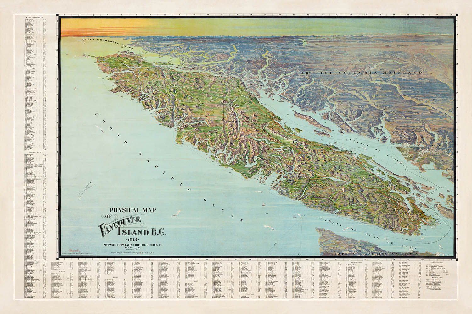
Adéntrese en los albores del siglo XX con este exquisito “Physical Map of Vancouver Island, B.C.” de 1913, meticulosamente elaborado por el renombrado cartógrafo J. H. Kennedy. Este mapa no solo es una cautivadora vista panorámica de la Isla de Vancouver, sino también un notable documento histórico que captura una era crucial en el desarrollo de la isla. La atención de Kennedy al detalle da vida a la intrincada red de carreteras, ferrocarriles y líneas de vapores que conectaban comunidades y facilitaban el comercio, ofreciendo una rara visión de la infraestructura que moldeó el crecimiento de la región durante un período de cambio dinámico.
El estilo artístico del mapa combina utilidad y elegancia, con rasgos topográficos cuidadosamente representados, como cordilleras, ríos, lagos y la espectacular costa de la isla. Ciudades importantes como Victoria, Nanaimo y Alberni están claramente señaladas, junto con asentamientos menores y puestos avanzados, proporcionando una visión completa de la geografía humana de la Isla de Vancouver tal como era en 1913. La inclusión de un índice detallado en los márgenes mejora aún más el valor orientativo del mapa, convirtiéndolo en un recurso indispensable tanto para historiadores como para coleccionistas.
Lo que realmente distingue a este mapa es su capacidad para transmitir la interacción entre los paisajes naturales y la actividad humana. La representación de los ferrocarriles y las rutas de vapores subraya la importancia del transporte para conectar las comunidades remotas de la isla, mientras que la representación pictórica de los bosques, la naturaleza salvaje y los rasgos costeros evoca la belleza agreste que ha definido durante mucho tiempo a la Isla de Vancouver. El mapa también señala áreas de actividad económica, como regiones de tala y minería, destacando las industrias que en aquel momento eran centrales para la prosperidad de la isla.
Más allá de sus usos prácticos, este mapa sirve como una ventana al pasado, capturando un momento en que la Isla de Vancouver estaba al borde de la modernidad. El cuidadoso señalamiento de asentamientos indígenas, faros, terminales de ferry y ayudas a la navegación habla de las diversas comunidades y del patrimonio marítimo que han moldeado la identidad de la isla. La importancia histórica del mapa se ve aún más reforzada por su papel en la documentación de los patrones de asentamiento y las redes de transporte que sentaron las bases de la vibrante y conectada región que conocemos hoy.
Poseer este mapa es como poseer una parte de la historia viva de la Isla de Vancouver, testimonio de la visión y la maestría artesanal de J. H. Kennedy, y una celebración del espíritu perdurable de la isla. Ya sea exhibido como una obra de arte o estudiado como un artefacto histórico, este mapa de 1913 le invita a explorar los paisajes, las historias y los trayectos que han definido la Isla de Vancouver durante generaciones.
Lugares en este mapa
- Victoria
- Nanaimo
- Alberni
- Esquimalt
- Duncan
- Ladysmith
- Courtenay
- Campbell River
- Port Alberni
- Qualicum
- Cowichan
- Chemainus
- Parksville
- Cumberland
- Union
- Sooke
- Sidney
- Ucluelet
- Port Renfrew
- Cape Scott
Características destacadas y monumentos
- Ferrocarriles claramente señalados que atraviesan la isla, incluido el Esquimalt & Nanaimo Railway
- Carreteras principales que conectan asentamientos y regiones clave
- Rutas de vapores a lo largo de la costa y conexión con el continente
- Representación detallada de cordilleras y picos prominentes
- Numerosos ríos y lagos señalados en toda la isla
- Características costeras como bahías, ensenadas y puertos
- Índice en los márgenes del mapa con poblaciones y rasgos físicos
- Áreas boscosas y regiones silvestres indicadas de forma pictórica
- Representación visual del terreno escarpado y del paisaje variado de la isla
- Anotaciones de comunidades más pequeñas y puestos avanzados
- Ubicaciones de faros y otras ayudas a la navegación
- Terminales de ferry y puntos de desembarco para vapores
- Límites definidos para las regiones y distritos dentro de la isla de Vancouver
- Representación destacada de la costa de la isla y de las islas cercanas
- Ríos y lagos nombrados, incluidos el lago Cowichan y el río Campbell
- Caminos y senderos que conducen a zonas remotas y sitios de recursos
- Áreas de actividad económica, como regiones de tala o minería, indicadas
- Anotaciones de asentamientos indígenas o reservas (cuando están etiquetados)
- Símbolos pictóricos para hitos significativos o rasgos naturales
- Incrustaciones o notas adicionales que proporcionan contexto o información sobre la isla
- La orientación y la escala del mapa claramente marcadas
- Elementos decorativos como un cartucho del título y un borde
Contexto histórico y de diseño
- Nombre del mapa: Mapa físico de la isla de Vancouver B.C.
- Cartógrafo: J. H. Kennedy, conocido por sus detallados e informativos mapas pictóricos a principios del siglo XX
- Fecha de creación: 1913
- Región representada: Isla de Vancouver, Columbia Británica, Canadá
- Mapa pictórico en vista de pájaro, que ofrece una perspectiva visualmente atractiva e informativa
- Destaca la topografía de la isla, incluidas montañas, ríos, lagos y costas
- Enfatiza tanto la geografía física como la infraestructura humana, como carreteras, ferrocarriles y líneas de vapores
- Los márgenes incluyen un índice de poblaciones y rasgos físicos significativos, lo que facilita la orientación y la comprensión
- Montado sobre lino para mayor durabilidad, adecuado para exhibición o manipulación frecuente
- Captura el desarrollo del sistema de transporte y los patrones de asentamiento de la isla de Vancouver a principios del siglo XX
- La inclusión de líneas de vapores refleja la importancia del transporte marítimo en la conexión de la isla de Vancouver con la Columbia Británica continental
- Recurso valioso para investigadores interesados en la geografía histórica de la isla de Vancouver
Por favor, compruebe cuidadosamente las imágenes para asegurarse de que se muestra una ciudad o lugar específico en este mapa. También puede ponerse en contacto con nosotros y pedirnos que revisemos el mapa por usted.
Este mapa luce magnífico en cualquier tamaño, pero siempre recomiendo optar por un tamaño mayor si dispone de espacio. Así podrá distinguir fácilmente todos los detalles.
Este mapa luce increíble en tamaños de hasta 100in (250cm). Si busca un mapa más grande, por favor póngase en contacto.
Tenga en cuenta: las etiquetas de este mapa son difíciles de leer si pide un mapa de 16in (40cm) o menos. El mapa sigue siendo muy atractivo, pero si desea leerlo con facilidad, por favor compre un tamaño mayor.
El modelo en las imágenes del anuncio sostiene la versión de 24x36in (60x90cm) de este mapa.
La quinta imagen del anuncio muestra un ejemplo de mi servicio de personalización de mapas.
Si busca algo un poco diferente, eche un vistazo a mi colección de los mejores mapas antiguos para ver si algo más le llama la atención.
Por favor contácteme para comprobar si una determinada ubicación, punto de referencia o rasgo aparece en este mapa.
Esto sería un regalo maravilloso de cumpleaños, Navidad, Día del Padre, despedida laboral, aniversario o inauguración de casa para alguien de las zonas cubiertas por este mapa.
Este mapa está disponible como impresión giclée en papel mate de archivo libre de ácido, o puede adquirirlo enmarcado. El marco es un bonito y sencillo marco negro que se adapta a la mayoría de las estéticas. Póngase en contacto con nosotros si desea un marco de otro color o material. Mis marcos están acristalados con acrílico de calidad museo supertransparente (perspex/acrylite), que es considerablemente menos reflectante que el vidrio, más seguro y que siempre llegará en perfectas condiciones.
This map is also available as a float framed canvas, sometimes known as a shadow gap framed canvas or canvas floater. The map is printed on artist's cotton canvas and then stretched over a handmade box frame. We then "float" the canvas inside a wooden frame, which is available in a range of colours (black, dark brown, oak, antique gold and white). This is a wonderful way to present a map without glazing in front. See some examples of float framed canvas maps and explore the differences between my different finishes.
For something truly unique, this map is also available in "Unique 3D", our trademarked process that dramatically transforms the map so that it has a wonderful sense of depth. We combine the original map with detailed topography and elevation data, so that mountains and the terrain really "pop". For more info and examples of 3D maps, check my Unique 3D page.
Many of our maps and art prints are chosen as thoughtful gifts for homes, offices, studies and meaningful places.
Choose a framed option for the easiest ready-to-hang gift, or choose an unframed print if the recipient may prefer to select their own frame.
We make orders locally in 23 countries around the world, so gifts can often be produced close to the recipient. This helps them arrive faster, travel more safely, and avoid customs or import duty surprises.
- We can deliver directly to the recipient
- Framed pieces arrive ready to hang
- Unframed prints are carefully packed in a strong protective tube
- Almost every order is made locally, for faster, safer gifting
- 90-day returns give the recipient time to decide
If you are not sure what to choose, please contact us. We can help you pick the right map, size, finish or delivery option.
Para la mayoría de los pedidos, el tiempo de entrega es de aproximadamente 3 días laborables. Los productos personalizados y a medida tardan más, ya que tengo que hacer la personalización y enviártelo para su aprobación, lo cual suele tardar 1 o 2 días.
Tenga en cuenta que los pedidos enmarcados muy grandes suelen tardar más en fabricarse y entregarse.
Si necesitas que tu pedido llegue para una fecha determinada, por favor contáctame antes de hacer el pedido para que podamos encontrar la mejor manera de asegurarnos de que recibas tu pedido a tiempo.
Imprimo y enmarco mapas y obras de arte en 23 países alrededor del mundo. Esto significa que tu pedido se fabricará localmente, lo que reduce el tiempo de entrega y asegura que no se dañe durante el envío. Nunca pagarás aranceles de aduana o impuestos de importación, y pondremos menos CO2 en el aire.
Todos mis mapas y impresiones artísticas están bien empaquetados y enviados en un tubo resistente si no están enmarcados, o rodeados de espuma si están enmarcados.
Intento enviar todos los pedidos dentro de 1 o 2 días después de recibir tu pedido, aunque algunos productos (como mascarillas, tazas y bolsas de tela) pueden tardar más en fabricarse.
Si seleccionas Entrega Exprés al finalizar la compra, priorizaremos tu pedido y lo enviaremos por mensajería de 1 día (Fedex, DHL, UPS, Parcelforce).
La entrega al día siguiente también está disponible en algunos países (EE. UU., Reino Unido, Singapur, EAU), pero por favor intenta hacer tu pedido temprano en el día para que podamos enviarlo a tiempo.
Mi marco estándar es un marco de madera de fresno negro estilo galería. Es simple y tiene un aspecto bastante moderno. Mi marco estándar tiene alrededor de 20 mm (0.8 in) de ancho.
Utilizo acrílico super claro (perspex/acrylite) para el vidrio del marco. Es más ligero y seguro que el vidrio, y se ve mejor, ya que la reflectividad es menor.
Seis colores de marco estándar están disponibles de forma gratuita (negro, marrón oscuro, gris oscuro, roble, blanco y oro antiguo).El enmarcado y montaje/matizado personalizado está disponible si buscas algo diferente.
La mayoría de los mapas, arte e ilustraciones también están disponibles como un lienzo enmarcado. Utilizamos lienzo de algodón mate (no brillante), lo estiramos sobre un marco de madera de caja de origen sostenible, y luego 'flotamos' la pieza dentro de un marco de madera. El resultado final es bastante hermoso, y no hay cristal que se interponga.
Todos los marcos se proporcionan "listos para colgar", con una cuerda o soportes en la parte posterior. Los marcos muy grandes tendrán placas de colgar de alta resistencia y/o un listón de montaje. Si tienes alguna pregunta, por favor ponte en contacto.
Mira algunos ejemplos de mis mapas enmarcados y mapas en lienzo enmarcados.
Alternativamente, también puedo proporcionar mapas antiguos y obras de arte en lienzo, tablero de espuma, papel de algodón y otros materiales.
Si deseas enmarcar tu mapa o obra de arte tú mismo, por favor lee mi guía de tamaños primero.
Mis mapas son reproducciones de mapas originales de altísima calidad.
Obtengo mapas originales y raros de bibliotecas, casas de subastas y colecciones privadas de todo el mundo, los restauro en mi taller de Londres y luego uso tintas e impresoras giclée especializadas para crear hermosos mapas que lucen incluso mejor que el original.
Mis mapas están impresos en papel de archivo mate (no brillante) sin ácido que se siente de muy alta calidad y casi como una tarjeta. En términos técnicos, el peso/grosor del papel es de 10 mil/200 g/m². Es perfecto para enmarcar.
Imprimo con tintas pigmentadas Epson ultrachrome giclée UV resistentes a la decoloración, algunas de las mejores tintas que puedes encontrar.
yo también puedo hacer mapas sobre lienzo, trapo de algodón y otros materiales exóticos.
Obtenga más información sobre The Unique Maps Co..
Personalización de mapas
Si está buscando el regalo perfecto de aniversario o inauguración de la casa, puedo personalizar su mapa para hacerlo verdaderamente único. Por ejemplo, puedo agregar un mensaje corto, resaltar una ubicación importante o agregar el escudo de armas de su familia.
Las opciones son casi infinitas. Por favor mira mi página de personalización de mapas para ver algunos maravillosos ejemplos de lo que es posible.
Para pedir un mapa personalizado, seleccione "personalizar su mapa" antes de agregarlo a su carrito.
Ponerse en contacto si buscas personalizaciones y personalizaciones más complejas.
Envejecimiento del mapa
A lo largo de los años, los clientes me han preguntado cientos de veces si podían comprar un mapa que se viera uniforme. más viejo.
Bueno, ahora puedes hacerlo seleccionando Envejecido antes de agregar un mapa a tu carrito.
Todas las fotografías de productos que ve en esta página muestran el mapa en su forma original. Así es como se ve el mapa hoy.
Si selecciona Envejecido, envejeceré su mapa a mano, usando un proceso especial y único desarrollado a través de años de estudiar mapas antiguos, hablar con investigadores para comprender la química del envejecimiento del papel y, por supuesto... ¡mucha práctica!
Si no estás seguro, quédate con el color original del mapa. Si quieres algo un poco más oscuro y más viejo buscando, opte por Envejecido.
Si no estás satisfecho con tu pedido por cualquier motivo, contáctame para un reembolso sin complicaciones. Por favor, consulta nuestra política de devoluciones y reembolsos para más información.
Estoy muy seguro de que te gustará tu mapa o impresión artística restaurada. He estado haciendo esto desde 1984. Soy un vendedor de 5 estrellas en Etsy. He vendido decenas de miles de mapas e impresiones artísticas y tengo más de 5,000 opiniones reales de 5 estrellas.
Utilizo un proceso único para restaurar mapas y obras de arte que consume mucho tiempo y mano de obra. Buscar los mapas e ilustraciones originales puede llevar meses. Utilizo tecnología de última generación y extremadamente cara para escanear y restaurarlos. Como resultado, garantizo que mis mapas e impresiones artísticas son superiores a los demás - por eso puedo ofrecer un reembolso sin complicaciones.
Casi todos mis mapas e impresiones artísticas se ven increíbles en tamaños grandes (200cm, 6.5ft+) y también puedo enmarcarlos y entregártelos a través de un servicio de mensajería especial para tamaños grandes. Contáctame para discutir tus necesidades específicas.
Or try searching for something!


