


Mapa pictórico de Oklahoma de Ruth Taylor White, 1935: Oklahoma City, Tulsa, campos petrolíferos, motivos nativos americanos, era del Dust Bowl
20% de descuento en 2 — 33% de descuento en 3
Añade dos artículos elegibles a tu carrito para recibir 20% de descuento. Añade un tercero y será complementario (equivalente a 33% de descuento al comprar tres).
No se necesita código — la oferta se aplica automáticamente al finalizar la compra.
Válido en todos los mapas estándar y impresiones de arte fino. Puedes mezclar y combinar cualquier diseño.
Si deseas enviar artículos a múltiples direcciones, por favor contáctanos antes de realizar tu pedido.
Las comisiones personalizadas y a medida están excluidas.
Contáctanos si tienes alguna pregunta
 Diseñado en Londres Hecho en Australia
Diseñado en Londres • Hecho en Australia
Diseñado en Londres Hecho en Australia
Diseñado en Londres • Hecho en Australia

Choose your size
Choose your finish


(Más información)
Mensaje de regalo y acabado personalizado

Si deseas agregar un mensaje de regalo, o un acabado (rompecabezas, tablero de aluminio, etc.) que no esté disponible aquí, por favor solicítalo en la "nota del pedido" cuando realices la compra.
Cada pedido es hecho a medida, así que si necesitas que el tamaño se ajuste ligeramente, o que se imprima en un material inusual, háznoslo saber. Hemos realizado miles de pedidos personalizados a lo largo de los años, así que hay (casi) nada que no podamos gestionar.
También puedes contactarnos antes de hacer tu pedido, ¡si lo prefieres!

- Made locally for fast, safe delivery
- No import duty or hidden fees
- Need advice? Message us on WhatsApp
Own a piece of history
7,000+ 5 star reviews


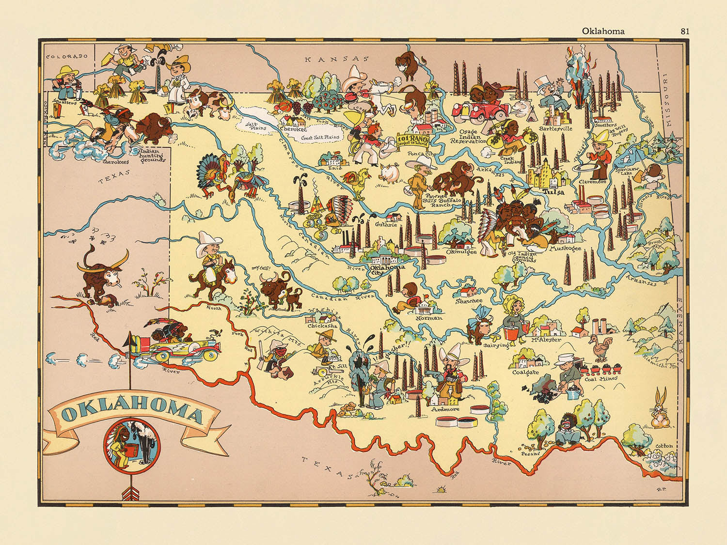
Adéntrese en el vibrante mundo del Oklahoma de la década de 1930 con el cautivador mapa pictórico titulado "Oklahoma", creado por la reconocida Ruth Taylor White en 1935. Este mapa es una magistral combinación de arte y documentación histórica, que ofrece una ventana única al carácter y la cultura del Estado Sooner durante una época decisiva. Ricamente adornado con ilustraciones caprichosas, el mapa atrae de inmediato la mirada con sus representaciones lúdicas de la vida cotidiana, las industrias regionales y la belleza natural que definían Oklahoma a principios del siglo XX. Cada detalle está meticulosamente realizado, convirtiendo este mapa no solo en una herramienta de orientación, sino también en un vívido artefacto histórico que encapsula el espíritu de su tiempo.
Ruth Taylor White, célebre por sus imaginativas obras cartográficas, da vida a Oklahoma mediante su estilo distintivo: una cautivadora fusión de humor, color y conocimiento cultural. Sus mapas, a menudo realizados en colaboración con su esposo Frank Taylor, son muy apreciados por los coleccionistas por su capacidad de transformar la geografía en narración. Aquí, la visión artística de White se despliega en todo su esplendor: torres de extracción petrolera se alzan sobre las llanuras, vaqueros y rancheros cuidan el ganado, y motivos indígenas rinden homenaje al profundo legado nativo del estado. Cada ilustración cumple una doble función: deleitar al observador y ofrecer una instantánea de la diversa economía y las vibrantes tradiciones de Oklahoma.
El diseño del mapa es un testimonio del enfoque temático y pictórico que definió la obra de Ruth Taylor White. Los límites de los condados están trazados con nitidez, invitando a explorar las diversas regiones de Oklahoma, mientras que coloridas viñetas ponen de relieve la abundancia agrícola: campos de trigo, plantas de algodón y equipos agrícolas abundan. La presencia de bisontes, tornados y ríos ancla además el mapa en las realidades físicas y los fenómenos naturales del estado. Estos elementos no solo realzan el atractivo visual del mapa, sino que también ofrecen una valiosa mirada educativa a los paisajes y medios de vida que forjaron la identidad de Oklahoma durante la década de 1930.
Más allá de su encanto estético, este mapa ofrece un notable contexto histórico. Creado durante la era del Dust Bowl, refleja tanto los desafíos como la resiliencia de los habitantes de Oklahoma en un momento de profunda transformación para el estado. Las ilustraciones captan la interacción entre tradición y progreso, con escenas de música folklórica y rodeos junto a industrias en auge. El decorativo cartucho del título y los animados diseños del borde refuerzan su papel como pieza de coleccionista y tema de conversación, tendiendo un puente entre pasado y presente con ingenio y calidez.
Para quienes sienten pasión por la historia estadounidense, la cartografía antigua o la singular historia de Oklahoma, este mapa es un auténtico tesoro por descubrir. Ciudades y localidades importantes como Oklahoma City, Tulsa, Norman y Lawton aparecen de forma prominente, con su relevancia actual prefigurada por su presencia en este histórico lienzo. La celebración de los iconos culturales, las maravillas naturales y los hitos económicos del estado garantiza que siga siendo un tributo atemporal al perdurable legado de Oklahoma. "Oklahoma" de Ruth Taylor White no es simplemente un mapa: es un vibrante tapiz que invita a recorrer una época pasada con cada mirada.
Ciudades y localidades en este mapa
- Oklahoma City
- Tulsa
- Norman
- Lawton
- Broken Arrow
- Edmond
- Moore
- Midwest City
- Enid
- Stillwater
- Muskogee
- Bartlesville
- Shawnee
- Owasso
- Yukon
- Ponca City
- Ardmore
- Duncan
- Del City
- Sapulpa
Características destacadas y lugares de interés
- Los límites de los condados están claramente delineados y etiquetados en todo Oklahoma.
- Ilustraciones de torres de extracción petrolera, en referencia a la industria petrolera prominente en Oklahoma.
- Representaciones de figuras y motivos nativos americanos, que reflejan la importante historia indígena del estado.
- Ilustraciones de escenas de ganado y ranchos, que destacan la economía agrícola y ganadera de Oklahoma.
- Imágenes de trigo y equipo agrícola, que representan la importancia de la agricultura.
- Dibujos de vaqueros y escenas de rodeo, que enfatizan los temas culturales del Oeste.
- Representaciones pictóricas de bisontes (búfalos), símbolo de las Grandes Llanuras y de la fauna de Oklahoma.
- Ilustraciones de instrumentos musicales y bailarines, en referencia a las tradiciones folclóricas y musicales de Oklahoma.
- Imágenes de plantas de algodón, que indican el cultivo de algodón en el estado.
- Referencias visuales a tornados, aludiendo a los patrones meteorológicos de Oklahoma.
- Representaciones artísticas de los ríos y lagos del estado.
- El mapa incluye una cartela ornamental con el nombre "Oklahoma."
- Ilustraciones temáticas que evocan la era del Dust Bowl, relevantes para la historia de Oklahoma en la década de 1930.
Contexto histórico y de diseño
- Nombre del mapa: Oklahoma.
- Cartógrafa: Ruth Taylor White.
- Fecha de creación: 1935.
- Parte de un atlas pictórico de los Estados Unidos, conocido por su estilo caprichoso y entretenido.
- Estilo artístico: ricamente adornado con ilustraciones vibrantes y coloridas, y representaciones juguetonas de estilo caricaturesco.
- Temas: escenas estereotípicas de la cultura, la economía y la geografía de Oklahoma tal como se percibían en la década de 1930.
- Propósito: tanto orientativo como decorativo; sirve como artefacto histórico que refleja las normas sociales y la imaginería popular de Oklahoma a principios del siglo XX.
- Alcance geográfico: todo el estado de Oklahoma, con los límites de los condados claramente marcados.
- Destacado por: su arte caprichoso y su representación informativa, atractivo para coleccionistas de mapas antiguos y para quienes se interesan por la historia de los estados estadounidenses.
- Contexto sobre la cartógrafa: Ruth Taylor White era conocida por sus mapas pictóricos que combinaban humor, arte y contenido informativo, colaborando a menudo con su esposo Frank Taylor.
Por favor, revise las imágenes cuidadosamente para asegurarse de que una ciudad o lugar específico aparece en este mapa. También puede ponerse en contacto con nosotros y pedirnos que revisemos el mapa por usted.
Este mapa luce великолепoso en cualquier tamaño, pero siempre recomiendo optar por un tamaño mayor si dispone de espacio. De ese modo, podrá apreciar fácilmente todos los detalles.
Este mapa se ve increíble en tamaños de hasta 50in (125cm). Si busca un mapa más grande, por favor póngase en contacto.
El modelo en las imágenes del anuncio está sosteniendo la versión de 18x24in (45x60cm) de este mapa.
La quinta imagen del anuncio muestra un ejemplo de mi servicio de personalización de mapas.
Si busca algo ligeramente diferente, explore mi colección de los mejores mapas antiguos para ver si algo más llama su atención.
Por favor, contácteme para comprobar si una determinada ubicación, lugar de interés o característica aparece en este mapa.
Sería un regalo maravilloso de cumpleaños, Navidad, Día del Padre, despedida del trabajo, aniversario o inauguración del hogar para alguien de las zonas cubiertas por este mapa.
Este mapa está disponible como impresión giclée en papel mate de archivo libre de ácido, o puede adquirirlo enmarcado. El marco es bonito, sencillo y negro, y combina con la mayoría de los estilos decorativos. No dude en ponerse en contacto si desea un color o material de marco diferente. Mis marcos llevan un acristalamiento de acrílico de grado museo ultratransparente (perspex/acrylite), que es considerablemente menos reflectante que el vidrio, más seguro y llegará siempre en perfectas condiciones.
This map is also available as a float framed canvas, sometimes known as a shadow gap framed canvas or canvas floater. The map is printed on artist's cotton canvas and then stretched over a handmade box frame. We then "float" the canvas inside a wooden frame, which is available in a range of colours (black, dark brown, oak, antique gold and white). This is a wonderful way to present a map without glazing in front. See some examples of float framed canvas maps and explore the differences between my different finishes.
For something truly unique, this map is also available in "Unique 3D", our trademarked process that dramatically transforms the map so that it has a wonderful sense of depth. We combine the original map with detailed topography and elevation data, so that mountains and the terrain really "pop". For more info and examples of 3D maps, check my Unique 3D page.
Many of our maps and art prints are chosen as thoughtful gifts for homes, offices, studies and meaningful places.
Choose a framed option for the easiest ready-to-hang gift, or choose an unframed print if the recipient may prefer to select their own frame.
We make orders locally in 23 countries around the world, so gifts can often be produced close to the recipient. This helps them arrive faster, travel more safely, and avoid customs or import duty surprises.
- We can deliver directly to the recipient
- Framed pieces arrive ready to hang
- Unframed prints are carefully packed in a strong protective tube
- Almost every order is made locally, for faster, safer gifting
- 90-day returns give the recipient time to decide
If you are not sure what to choose, please contact us. We can help you pick the right map, size, finish or delivery option.
Para la mayoría de los pedidos, el tiempo de entrega es de aproximadamente 3 días laborables. Los productos personalizados y a medida tardan más, ya que tengo que hacer la personalización y enviártelo para su aprobación, lo cual suele tardar 1 o 2 días.
Tenga en cuenta que los pedidos enmarcados muy grandes suelen tardar más en fabricarse y entregarse.
Si necesitas que tu pedido llegue para una fecha determinada, por favor contáctame antes de hacer el pedido para que podamos encontrar la mejor manera de asegurarnos de que recibas tu pedido a tiempo.
Imprimo y enmarco mapas y obras de arte en 23 países alrededor del mundo. Esto significa que tu pedido se fabricará localmente, lo que reduce el tiempo de entrega y asegura que no se dañe durante el envío. Nunca pagarás aranceles de aduana o impuestos de importación, y pondremos menos CO2 en el aire.
Todos mis mapas y impresiones artísticas están bien empaquetados y enviados en un tubo resistente si no están enmarcados, o rodeados de espuma si están enmarcados.
Intento enviar todos los pedidos dentro de 1 o 2 días después de recibir tu pedido, aunque algunos productos (como mascarillas, tazas y bolsas de tela) pueden tardar más en fabricarse.
Si seleccionas Entrega Exprés al finalizar la compra, priorizaremos tu pedido y lo enviaremos por mensajería de 1 día (Fedex, DHL, UPS, Parcelforce).
La entrega al día siguiente también está disponible en algunos países (EE. UU., Reino Unido, Singapur, EAU), pero por favor intenta hacer tu pedido temprano en el día para que podamos enviarlo a tiempo.
Mi marco estándar es un marco de madera de fresno negro estilo galería. Es simple y tiene un aspecto bastante moderno. Mi marco estándar tiene alrededor de 20 mm (0.8 in) de ancho.
Utilizo acrílico super claro (perspex/acrylite) para el vidrio del marco. Es más ligero y seguro que el vidrio, y se ve mejor, ya que la reflectividad es menor.
Seis colores de marco estándar están disponibles de forma gratuita (negro, marrón oscuro, gris oscuro, roble, blanco y oro antiguo).El enmarcado y montaje/matizado personalizado está disponible si buscas algo diferente.
La mayoría de los mapas, arte e ilustraciones también están disponibles como un lienzo enmarcado. Utilizamos lienzo de algodón mate (no brillante), lo estiramos sobre un marco de madera de caja de origen sostenible, y luego 'flotamos' la pieza dentro de un marco de madera. El resultado final es bastante hermoso, y no hay cristal que se interponga.
Todos los marcos se proporcionan "listos para colgar", con una cuerda o soportes en la parte posterior. Los marcos muy grandes tendrán placas de colgar de alta resistencia y/o un listón de montaje. Si tienes alguna pregunta, por favor ponte en contacto.
Mira algunos ejemplos de mis mapas enmarcados y mapas en lienzo enmarcados.
Alternativamente, también puedo proporcionar mapas antiguos y obras de arte en lienzo, tablero de espuma, papel de algodón y otros materiales.
Si deseas enmarcar tu mapa o obra de arte tú mismo, por favor lee mi guía de tamaños primero.
Mis mapas son reproducciones de mapas originales de altísima calidad.
Obtengo mapas originales y raros de bibliotecas, casas de subastas y colecciones privadas de todo el mundo, los restauro en mi taller de Londres y luego uso tintas e impresoras giclée especializadas para crear hermosos mapas que lucen incluso mejor que el original.
Mis mapas están impresos en papel de archivo mate (no brillante) sin ácido que se siente de muy alta calidad y casi como una tarjeta. En términos técnicos, el peso/grosor del papel es de 10 mil/200 g/m². Es perfecto para enmarcar.
Imprimo con tintas pigmentadas Epson ultrachrome giclée UV resistentes a la decoloración, algunas de las mejores tintas que puedes encontrar.
yo también puedo hacer mapas sobre lienzo, trapo de algodón y otros materiales exóticos.
Obtenga más información sobre The Unique Maps Co..
Personalización de mapas
Si está buscando el regalo perfecto de aniversario o inauguración de la casa, puedo personalizar su mapa para hacerlo verdaderamente único. Por ejemplo, puedo agregar un mensaje corto, resaltar una ubicación importante o agregar el escudo de armas de su familia.
Las opciones son casi infinitas. Por favor mira mi página de personalización de mapas para ver algunos maravillosos ejemplos de lo que es posible.
Para pedir un mapa personalizado, seleccione "personalizar su mapa" antes de agregarlo a su carrito.
Ponerse en contacto si buscas personalizaciones y personalizaciones más complejas.
Envejecimiento del mapa
A lo largo de los años, los clientes me han preguntado cientos de veces si podían comprar un mapa que se viera uniforme. más viejo.
Bueno, ahora puedes hacerlo seleccionando Envejecido antes de agregar un mapa a tu carrito.
Todas las fotografías de productos que ve en esta página muestran el mapa en su forma original. Así es como se ve el mapa hoy.
Si selecciona Envejecido, envejeceré su mapa a mano, usando un proceso especial y único desarrollado a través de años de estudiar mapas antiguos, hablar con investigadores para comprender la química del envejecimiento del papel y, por supuesto... ¡mucha práctica!
Si no estás seguro, quédate con el color original del mapa. Si quieres algo un poco más oscuro y más viejo buscando, opte por Envejecido.
Si no estás satisfecho con tu pedido por cualquier motivo, contáctame para un reembolso sin complicaciones. Por favor, consulta nuestra política de devoluciones y reembolsos para más información.
Estoy muy seguro de que te gustará tu mapa o impresión artística restaurada. He estado haciendo esto desde 1984. Soy un vendedor de 5 estrellas en Etsy. He vendido decenas de miles de mapas e impresiones artísticas y tengo más de 5,000 opiniones reales de 5 estrellas.
Utilizo un proceso único para restaurar mapas y obras de arte que consume mucho tiempo y mano de obra. Buscar los mapas e ilustraciones originales puede llevar meses. Utilizo tecnología de última generación y extremadamente cara para escanear y restaurarlos. Como resultado, garantizo que mis mapas e impresiones artísticas son superiores a los demás - por eso puedo ofrecer un reembolso sin complicaciones.
Casi todos mis mapas e impresiones artísticas se ven increíbles en tamaños grandes (200cm, 6.5ft+) y también puedo enmarcarlos y entregártelos a través de un servicio de mensajería especial para tamaños grandes. Contáctame para discutir tus necesidades específicas.
Or try searching for something!


