


Grande vieille carte d'Oxford par Hoggar, 1850: Collèges, St. Giles', High St, Magdalen St, rivière Thames
Achetez 2, obtenez 1 gratuit
Si vous ajoutez 2 articles à votre panier, vous pouvez ajouter un troisième produit gratuitement.
Cela fonctionne pour toutes les cartes et œuvres d'art, y compris les pièces personnalisées et sur mesure. Vous pouvez commander 3 de la même chose, ou 3 choses différentes.
Cela équivaut à une remise de 33 %, qui sera la plus grande remise disponible dans ma boutique cette année.
Veuillez profiter de l'offre et couvrir vos murs de belles cartes et œuvres d'art !
Contactez-moi si vous avez des questions.

-
![]() Handmade in Australia
Handmade in Australia
-
Free delivery &
usually dispatched next day
Dispatched next working day
Your map should be dispatched the next working day.
Express delivery is available at checkout.
If you need your order to arrive by a certain date, contact me and we can discuss your options.
Please note that personalised maps, and some larger framed maps can take longer to produce and deliver.
-
90 day money back guarantee
ⓘ
90 jours pour retourner et obtenir un remboursement
Les produits peuvent être retournés dans les 90 jours pour un remboursement complet, ou un échange contre un autre produit.
Pour les articles personnalisés ou sur mesure, nous pouvons vous offrir un crédit en magasin ou une carte-cadeau sans date d'expiration, car nous ne pouvons pas revendre les commandes personnalisées.
Si vous avez des questions, contactez-nous. Pour plus d'informations, consultez notre politique de retours et d'échanges.

My maps are rare, museum-grade, restored old maps sourced from libraries, auction houses and private collections across the globe.
Framing & free personalisation available
1. Select your size
2. Customise your map
Personalise your map with framing, hand-drawn customisation, vintage ageing, pop art text, unique 3D styling and moreMessage cadeau & finition personnalisée

Si vous souhaitez ajouter un message cadeau, ou une finition (puzzle, panneau en aluminium, etc.) qui n'est pas disponible ici, veuillez le demander dans la "note de commande" lors de votre passage à la caisse.
Chaque commande est fabriquée sur mesure, donc si vous avez besoin d'ajuster légèrement la taille, ou d'imprimer sur un matériau inhabituel, faites-le nous savoir. Nous avons réalisé des milliers de commandes personnalisées au fil des ans, donc il n'y a (presque) rien que nous ne puissions gérer.
Vous pouvez également nous contacter avant de passer votre commande, si vous le souhaitez !

- Handmade locally. No import duty or tax
- FREE Delivery. Arrives in 2-3 days
- Love it or your money back
- Questions? WhatsApp me any time
Own a piece of history
5,000+ 5 star reviews


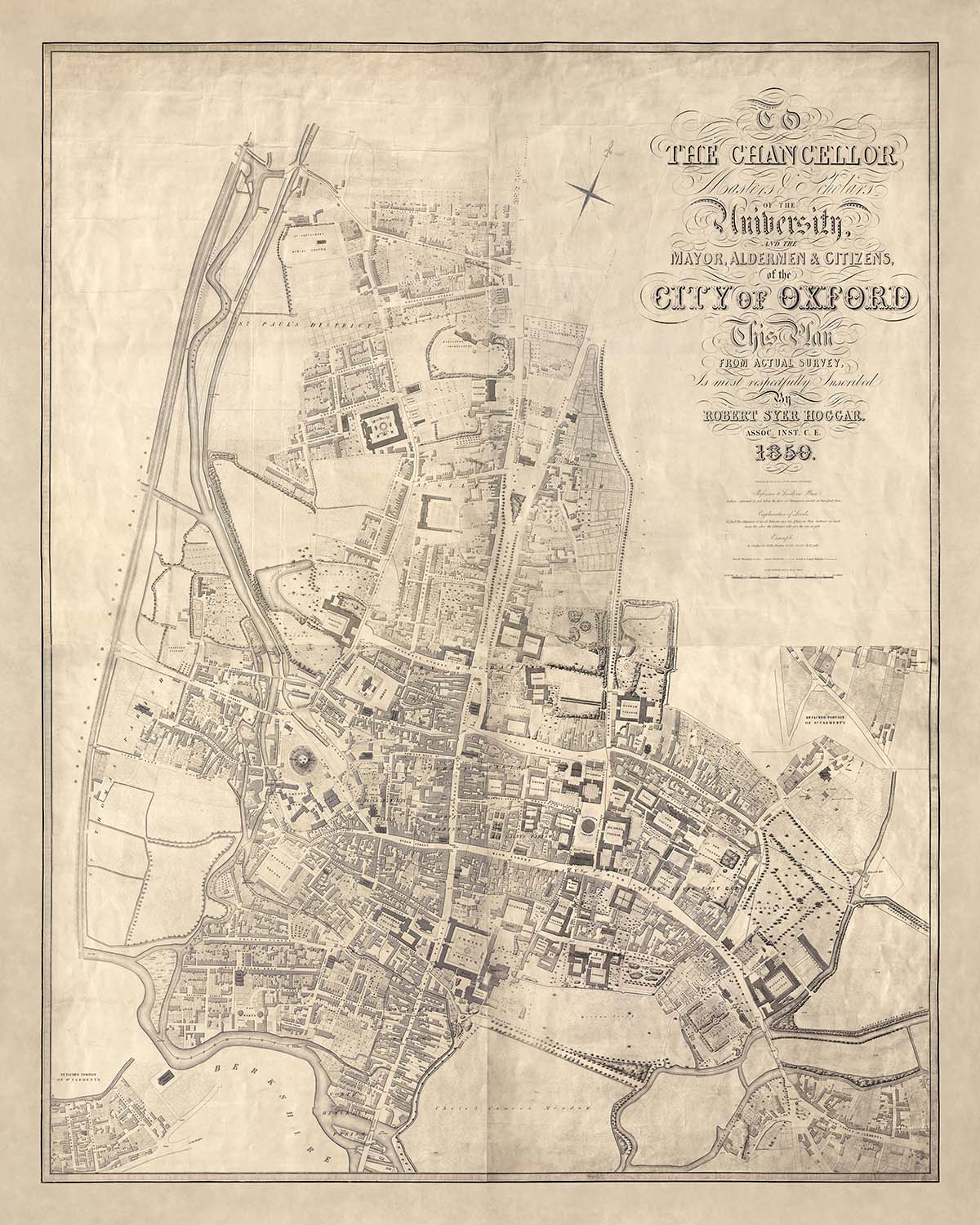
Le "Plan de la ville d'Oxford" par Robert Syer Hoggar, réalisé en 1850, est un aperçu captivant du cœur historique de l'une des villes les plus renommées d'Angleterre. Cette carte, produite pour l'enquête sanitaire des commissaires de pavage d'Oxford de 1851, n'est pas seulement un outil de navigation mais un portrait détaillé de la vie urbaine au milieu du 19e siècle. Avec sa représentation méticuleuse des principaux bâtiments d'Oxford, des collèges et des limites de comté et de paroisse clairement marquées, elle offre une fenêtre sur le paysage architectural et civique de l'époque. La précision et l'élégance de la carte reflètent l'expertise de Hoggar en tant qu'associé de l'Institution des ingénieurs civils.
Le travail de Robert Syer Hoggar est un témoignage de l'art et de la science de la cartographie au 19e siècle. Son association avec l'Institution des ingénieurs civils souligne son engagement envers la précision et le détail, faisant de cette carte une ressource inestimable pour les historiens et les passionnés. Gravée par Thos. Jones, la carte est un chef-d'œuvre de design, mettant en valeur les motifs de rues complexes et les points de repère significatifs qui définissent Oxford. Le dévouement de Hoggar à son art est évident dans chaque ligne et contour, capturant l'essence d'une ville imprégnée d'histoire et de tradition.
Oxford, avec sa riche tapisserie de quartiers et de monuments, prend vie à travers la carte de Hoggar. La représentation de zones telles que St. Giles' et Cornmarket Street révèle le tissu urbain vibrant de la ville. Chaque rue et bâtiment est soigneusement rendu, offrant des aperçus sur la vie quotidienne et la structure sociale de l'époque. L'inclusion de voies significatives comme High Street et Magdalen Street met en évidence les activités commerciales et académiques animées qui ont longtemps été la marque de la ville.
La carte offre également un regard fascinant sur l'environnement naturel et bâti d'Oxford. La présence de la rivière Thames, serpentant à travers la ville, ajoute un élément dynamique au paysage urbain. Le marquage soigné des parcs et des espaces ouverts reflète l'engagement de la ville envers les zones vertes au milieu de sa splendeur architecturale. Cet équilibre entre la nature et l'urbanité est une caractéristique déterminante d'Oxford, et la carte de Hoggar le capture avec une clarté et une beauté remarquables.
En essence, le "Plan de la ville d'Oxford" est plus qu'une simple carte ; c'est un document historique qui capture l'esprit d'une ville à un moment charnière de son développement. Sa représentation détaillée des rues, des bâtiments et des limites d'Oxford offre une perspective unique sur l'évolution de la ville et son héritage durable. Pour les collectionneurs et les historiens, cette carte est un trésor d'informations et un témoignage de l'art et de la précision de la cartographie du 19e siècle.
Rues et routes sur cette carte
- Banbury Road
- Beaumont Street
- Broad Street
- Cornmarket Street
- George Street
- High Street
- Holywell Street
- Longwall Street
- Magdalen Street
- New Inn Hall Street
- New Road
- Parks Road
- Queen Street
- St. Aldate's
- St. Clement's Street
- St. Giles'
- St. John Street
- Turl Street
- Walton Street
- Wellington Square
- Worcester Street
Caractéristiques et monuments notables
- Cartes insets :
- Deux cartes insets de portions détachées de la paroisse de St. Clement's.
- Monuments :
- De nombreux bâtiments principaux sont nommés.
- Quartiers :
- Disposition détaillée des rues et des quartiers au sein d'Oxford.
- Collèges :
- Tous les collèges d'Oxford existants en 1850 sont clairement indiqués sur cette carte
Contexte historique et de conception
- Date de création : 1850
- Cartographe / Éditeur : Robert Syer Hoggar, gravé par Thos. Jones
- Objectif : Produit pour l'enquête sanitaire des commissaires des pavés d'Oxford de 1851.
- Thèmes et sujets :
- Illustre les bâtiments principaux et marque les limites des comtés et des paroisses.
- Échelle : 1 pouce pour 44 pieds (1:1584).
- Régions montrées : La ville d'Oxford, Angleterre.
- Design / Style : Carte de rue détaillée mettant l'accent sur les bâtiments et les limites, typique de la planification urbaine et des cartes d'arpentage du milieu du XIXe siècle.
- Signification historique : Réflecte la planification urbaine et les préoccupations sanitaires de l'époque, fournissant des aperçus sur Oxford au milieu du XIXe siècle.
Veuillez vérifier les images pour vous assurer qu'une ville ou un lieu spécifique est montré sur cette carte. Vous pouvez également nous contacter et nous demander de vérifier la carte pour vous.
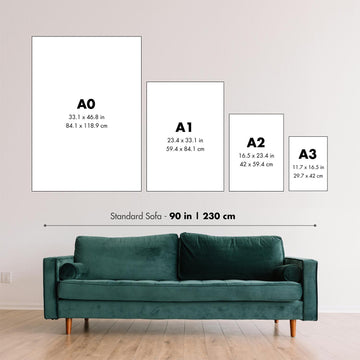
C'est une très grande carte qui doit être commandée à une grande taille, afin que vous puissiez facilement distinguer tous les détails.
Cette carte est magnifique à des tailles allant jusqu'à 100in (250cm). Si vous recherchez une carte plus grande, veuillez nous contacter.
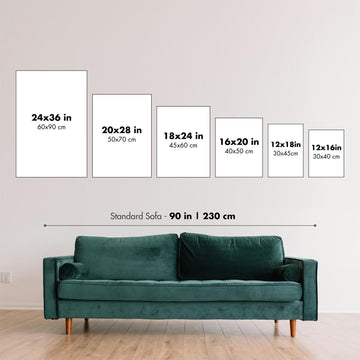
Le modèle dans les images de la liste tient la version 16x20in (40x50cm) de cette carte.
La cinquième image de la liste montre un exemple de mon service de personnalisation de carte.
Si vous recherchez quelque chose de légèrement différent, consultez ma collection des meilleures anciennes cartes pour voir si quelque chose d'autre attire votre attention.
Veuillez me contacter pour vérifier si un certain emplacement, un point de repère ou une caractéristique est montré sur cette carte.
Cela ferait un merveilleux cadeau d'anniversaire, de Noël, pour la fête des pères, pour un départ au travail, un anniversaire de mariage ou un cadeau de crémaillère pour quelqu'un des zones couvertes par cette carte.
Cette carte est disponible en tant qu'impression giclée sur papier mat d'archives sans acide, ou vous pouvez l'acheter encadrée. Le cadre est un joli cadre noir simple qui convient à la plupart des esthétiques. Veuillez nous contacter si vous souhaitez une couleur ou un matériau de cadre différent. Mes cadres sont en verre acrylique super clair de qualité musée (perspex / acrylite), qui est significativement moins réfléchissant que le verre, plus sûr, et arrivera toujours en parfait état.
This map is also available as a float framed canvas, sometimes known as a shadow gap framed canvas or canvas floater. The map is printed on artist's cotton canvas and then stretched over a handmade box frame. We then "float" the canvas inside a wooden frame, which is available in a range of colours (black, dark brown, oak, antique gold and white). This is a wonderful way to present a map without glazing in front. See some examples of float framed canvas maps and explore the differences between my different finishes.
For something truly unique, this map is also available in "Unique 3D", our trademarked process that dramatically transforms the map so that it has a wonderful sense of depth. We combine the original map with detailed topography and elevation data, so that mountains and the terrain really "pop". For more info and examples of 3D maps, check my Unique 3D page.
Pour la plupart des commandes, le délai de livraison est d'environ 3 jours ouvrables. Les produits personnalisés et sur mesure prennent plus de temps, car je dois faire la personnalisation et vous l'envoyer pour approbation, ce qui prend généralement 1 ou 2 jours.
Veuillez noter que les grandes commandes encadrées prennent généralement plus de temps à réaliser et à livrer.
Si vous avez besoin que votre commande arrive à une date précise, veuillez me contacter avant de passer votre commande afin que nous puissions trouver le meilleur moyen de nous assurer que vous receviez votre commande à temps.
J'imprime et encadre des cartes et des œuvres d'art dans 23 pays à travers le monde. Cela signifie que votre commande sera réalisée localement, ce qui réduit le temps de livraison et garantit qu'elle ne sera pas endommagée pendant le transport. Vous ne paierez jamais de droits de douane ou d'importation, et nous mettrons moins de CO2 dans l'air.
Toutes mes cartes et impressions artistiques sont bien emballées et envoyées dans un tube robuste si non encadrées, ou entourées de mousse si encadrées.
J'essaie d'envoyer toutes les commandes dans les 1 ou 2 jours suivant la réception de votre commande, bien que certains produits (comme les masques, les mugs et les sacs fourre-tout) puissent prendre plus de temps à réaliser.
Si vous choisissez Livraison Express lors du paiement, nous donnerons la priorité à votre commande et l'enverrons par un service de messagerie de 1 jour (Fedex, DHL, UPS, Parcelforce).
La livraison le lendemain est également disponible dans certains pays (États-Unis, Royaume-Uni, Singapour, Émirats Arabes Unis), mais veuillez essayer de commander tôt dans la journée afin que nous puissions l'envoyer à temps.
Lisez mon guide complet sur la livraison et la production locale
Mon cadre standard est un cadre en bois dur noir de style galerie. Il est simple et a un aspect assez moderne. Mon cadre standard mesure environ 20 mm (0,8 po) de large.
J'utilise de l'acrylique super clair (perspex/acrylite) pour le verre du cadre. C'est plus léger et plus sûr que le verre - et cela a meilleur aspect, car la réflexivité est plus faible.
Six couleurs de cadre standard sont disponibles gratuitement (noir, marron foncé, gris foncé, chêne, blanc et or antique). Des encadrements et montages/matelassages personnalisés sont disponibles si vous recherchez autre chose.
La plupart des cartes, œuvres d'art et illustrations sont également disponibles sous forme de toile encadrée. Nous utilisons une toile en coton mate (non brillante), que nous tendons sur un cadre en bois de boîte provenant de sources durables, puis nous 'flottions' la pièce à l'intérieur d'un cadre en bois. Le résultat final est assez beau, et il n'y a pas de vitrage qui gêne.
Tous les cadres sont fournis "prêts à accrocher", avec soit une corde, soit des supports à l'arrière. Les très grands cadres auront des plaques de suspension lourdes et/ou une latte de montage. Si vous avez des questions, veuillez nous contacter.
Voir quelques exemples de mes cartes encadrées et de cartes en toile encadrées.
Alternativement, je peux également fournir de vieilles cartes et œuvres d'art sur toile, sur panneau en mousse, en coton et d'autres matériaux.
Si vous souhaitez encadrer votre carte ou œuvre d'art vous-même, veuillez lire d'abord mon guide des tailles.
Certaines de mes anciennes cartes sont maintenant disponibles en tant que toiles encadrées. Veuillez me contacter si vous souhaitez commander une taille qui n'est pas disponible dans ma boutique.
Les anciennes cartes en toile sont une alternative intéressante aux cartes encadrées de manière conventionnelle. Selon vos goûts personnels et la décoration de votre pièce, les cartes en toile peuvent "se démarquer" un peu plus qu'une carte encadrée.
Mes cartes sont des reproductions de cartes originales de très haute qualité.
Je recherche des cartes originales et rares auprès de bibliothèques, de maisons de ventes aux enchères et de collections privées du monde entier, je les restaure dans mon atelier de Londres, puis j'utilise des encres et des imprimantes giclées spécialisées pour créer de magnifiques cartes encore plus belles que l'originale.
Mes cartes sont imprimées sur du papier d’archives mat (non brillant) sans acide qui semble de très haute qualité et ressemble presque à une carte. En termes techniques, le grammage/épaisseur du papier est de 10 mil/200 g/m². C'est parfait pour l'encadrement.
J’imprime avec des encres pigmentaires Epson ultrachrome giclée UV résistantes à la décoloration – certaines des meilleures encres que vous puissiez trouver.
je peux aussi faire cartes sur toile, chiffon en coton et autres matériaux exotiques.
En savoir plus sur Unique Maps Co..
Personnalisation de la carte
Si vous recherchez le cadeau parfait pour un anniversaire ou une pendaison de crémaillère, je peux personnaliser votre carte pour la rendre vraiment unique. Par exemple, je peux ajouter un court message, mettre en évidence un lieu important ou ajouter les armoiries de votre famille.
Les options sont presque infinies. S'il vous plaît voir mon page de personnalisation de la carte pour quelques merveilleux exemples de ce qui est possible.
Pour commander une carte personnalisée, sélectionnez « personnaliser votre carte » avant de l'ajouter à votre panier.
Entrer en contact si vous recherchez des personnalisations et des personnalisations plus complexes.
Vieillissement de la carte
Au fil des ans, des clients m'ont demandé des centaines de fois s'ils pouvaient acheter une carte qui semble uniforme. plus vieux.
Eh bien, vous pouvez désormais le faire en sélectionnant Aged avant d'ajouter une carte à votre panier.
Toutes les photos de produits que vous voyez sur cette page montrent la carte dans sa forme originale. Voilà à quoi ressemble la carte aujourd'hui.
Si vous sélectionnez Vieilli, je vieillirai votre carte à la main, en utilisant un processus spécial et unique développé au cours d'années d'étude de cartes anciennes, de discussions avec des chercheurs pour comprendre la chimie du vieillissement du papier, et bien sûr... beaucoup de pratique !
Si vous n'êtes pas sûr, respectez la couleur originale de la carte. Si vous voulez quelque chose d'un peu plus sombre et plus vieux à la recherche, optez pour Aged.
Si vous n'êtes pas satisfait de votre commande pour une raison quelconque, contactez-moi pour un remboursement sans conditions. Veuillez consulter notre politique de retours et de remboursements pour plus d'informations.
Je suis très confiant que vous aimerez votre carte restaurée ou votre impression artistique. Je fais cela depuis 1984. Je suis un vendeur Etsy 5 étoiles. J'ai vendu des dizaines de milliers de cartes et d'impressions artistiques et j'ai plus de 5 000 vrais avis 5 étoiles.
J'utilise un processus unique pour restaurer des cartes et des œuvres d'art qui est extrêmement chronophage et exigeant en main-d'œuvre. Trouver les cartes et illustrations originales peut prendre des mois. J'utilise une technologie de pointe et incroyablement coûteuse pour les numériser et les restaurer. En conséquence, je garantis que mes cartes et impressions artistiques sont d'une qualité supérieure - c'est pourquoi je peux offrir un remboursement sans conditions.
Presque toutes mes cartes et impressions artistiques ont l'air incroyables en grandes tailles (200 cm, 6,5 pieds+) et je peux également les encadrer et vous les livrer, via un transporteur spécial surdimensionné. Contactez-moi pour discuter de vos besoins spécifiques.
Or try searching for something!


