


Ancienne carte militaire et de rue de Carcassonne par Viollet-le-Duc, 1854: Fortifications de la Cité, Château, Basilique
Achetez 2, obtenez 1 gratuit
Si vous ajoutez 2 articles à votre panier, vous pouvez ajouter un troisième produit gratuitement.
Cela fonctionne pour toutes les cartes et œuvres d'art, y compris les pièces personnalisées et sur mesure. Vous pouvez commander 3 de la même chose, ou 3 choses différentes.
Cela équivaut à une remise de 33 %, qui sera la plus grande remise disponible dans ma boutique cette année.
Veuillez profiter de l'offre et couvrir vos murs de belles cartes et œuvres d'art !
Contactez-moi si vous avez des questions.
-
![]() Handmade in Australia
Handmade in Australia

-
Free delivery &
usually dispatched next day
Dispatched next working day
Your map should be dispatched the next working day.
Express delivery is available at checkout.
If you need your order to arrive by a certain date, contact me and we can discuss your options.
Please note that personalised maps, and some larger framed maps can take longer to produce and deliver.
-
Complimentary gifting & design advice
ⓘ
Complimentary gifting & design advice
Available almost 24/7 on WhatsApp and email — we usually reply within minutes. We can help you:
- Choose a perfectly personalised gift
- Send a digital gift preview to the recipient
- Pick the ideal size for your wall
- Select the right finish and frame
Quick, friendly advice so you can order with confidence.
For last minute gifts, consider buying a digital gift card. We have over 5,000 maps and art prints to choose from.
-
90-day returns & 5-year guarantee
ⓘ
90 jours pour retourner et obtenir un remboursement
Les produits peuvent être retournés dans les 90 jours pour un remboursement complet, ou un échange contre un autre produit.
Pour les articles personnalisés et faits sur mesure, nous pouvons vous offrir un crédit en magasin ou une carte-cadeau non expirante, car nous ne pouvons pas revendre les commandes personnalisées.
Si vous avez des questions, contactez-nous. Pour plus d'informations, consultez notre politique de retours et d'échanges.

This is a museum-grade archival print from the original 1854 map — restored in our workshop and made to order on 220gsm archival matte paper or 400gsm artist's cotton canvas with pigment inks.
Professional framing & free personalisation available
1. Choose a size
2. Frame & personalise your map
Make your map unique with framing, hand-drawn customisation, vintage ageing, pop art text, unique 3D styling and more.


Message cadeau & finition personnalisée

Si vous souhaitez ajouter un message cadeau, ou une finition (puzzle, panneau en aluminium, etc.) qui n'est pas disponible ici, veuillez le demander dans la "note de commande" lors de votre passage à la caisse.
Chaque commande est fabriquée sur mesure, donc si vous avez besoin d'ajuster légèrement la taille, ou d'imprimer sur un matériau inhabituel, faites-le nous savoir. Nous avons réalisé des milliers de commandes personnalisées au fil des ans, donc il n'y a (presque) rien que nous ne puissions gérer.
Vous pouvez également nous contacter avant de passer votre commande, si vous le souhaitez !

- Handmade locally. No import duty or tax
- FREE worldwide delivery
- 90-day returns & 5-year product guarantee
- Questions? WhatsApp me any time
Own a piece of history
7,000+ 5 star reviews


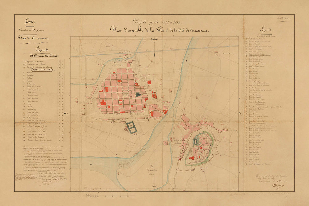
Le « Plan d'ensemble de la Ville et de la Cité de Carcassonne », créé en 1854 sous la direction d'Eugène-Emmanuel Viollet-le-Duc et du Colonel de Rivieres, se dresse comme un témoignage remarquable de l'intersection de l'histoire urbaine, de l'architecture militaire et de la science naissante de la conservation. Cette carte manuscrite de la ville capture Carcassonne à un moment charnière—juste au moment où sa restauration mondialement reconnue allait commencer—offrant un aperçu rare et authentique des fortifications médiévales de la ville, de la ville basse animée, et de l'interaction complexe entre les formes urbaines anciennes et modernes.
Ce qui distingue cette carte de la ville, c'est son double focus : la Cité fortifiée de Carcassonne, une merveille concentrique de l'ingénierie militaire médiévale, et la Ville Basse, la ville basse vibrante de l'autre côté de la rivière Aude. Le rendu détaillé de la Cité à double mur, complète avec tours, barbacanes et l'imposant Château Comtal, révèle les défenses redoutables de la ville—jamais franchies durant la guerre de Cent Ans et pratiquement intactes par le raid infâme du Prince Noir. Des monuments tels que la Basilique de Saint-Nazaire, déjà en cours de restauration à l'époque, sont clairement marqués, soulignant le riche patrimoine religieux et architectural de la ville.
L'art de la carte réside non seulement dans sa délimitation précise des fortifications mais aussi dans sa représentation réfléchie de la vie civile de Carcassonne. La Ville Basse est cartographiée avec le même soin, sa grille de rues médiévales et ses places proéminentes—comme la Place Carnot et la Place Gambetta—témoignant de siècles d'évolution civique. Les courbes gracieuses de la rivière Aude et les élégants passages du Pont Vieux et du Pont Neuf relient l'ancienne Cité aux quartiers animés de la ville basse, illustrant la relation dynamique de la ville avec son paysage et ses voies navigables. De telles caractéristiques font de cette carte une ressource inestimable pour quiconque captivé par les histoires stratifiées des villes européennes.
Historiquement, cette carte est d'une importance profonde. Créée à l'aube de la campagne de restauration de Viollet-le-Duc qui a duré un demi-siècle, elle documente Carcassonne telle qu'elle existait avant le retrait des structures ultérieures et la réhabilitation soigneuse de ses remparts, tours et portes. Les annotations et la légende codée par couleur, distinguant les fortifications civiles et militaires, reflètent la planification méticuleuse et la vision qui sauvera finalement Carcassonne de la ruine. En conséquence, cette carte ne trace pas seulement les contours physiques d'une ville mais aussi les courants intellectuels et culturels qui ont façonné la pratique moderne de la conservation du patrimoine.
Eugène-Emmanuel Viollet-le-Duc, l'esprit directeur de la carte, était un architecte visionnaire dont le travail à Carcassonne a influencé les principes de conservation dans le monde entier. Renommé pour ses restaurations interprétatives de Notre Dame de Paris, du Mont Saint-Michel et d'autres icônes françaises, Viollet-le-Duc a abordé Carcassonne avec à la fois une rigueur académique et une imagination créative. Son héritage, préservé dans cette carte extraordinaire, n'est pas seulement fait de pierre et de mortier mais d'une profonde révérence pour l'histoire, la forme urbaine et le pouvoir durable du lieu. Pour les collectionneurs, les historiens et les amateurs d'art cartographique, cette carte offre une rare opportunité de posséder un morceau de l'histoire vivante de Carcassonne—une ville dont les murs ont été témoins du passage des empires, des croyances et des siècles.
Rues et routes sur cette carte
- Allée des Soupirs
- Avenue de la Gare
- Avenue du Pont Neuf
- Boulevard Barbès
- Boulevard de la Bastide
- Boulevard de la Cité
- Boulevard de la Préfecture
- Boulevard du Canal
- Boulevard du Commandant Roumens
- Boulevard Marcou
- Boulevard Omer Sarraut
- Boulevard Pasteur
- Boulevard Paul Sabatier
- Boulevard Pierre Curie
- Boulevard Voltaire
- Chemin de la Cité
- Chemin de la Madeleine
- Chemin du Pont Vieux
- Place Carnot
- Place Davilla
- Place Eggenfelden
- Place Gambetta
- Place Marcou
- Place Saint-Gimer
- Place Saint-Louis
- Pont Neuf
- Pont Vieux
- Rue Aimé Ramond
- Rue de la Barbacane
- Rue de Verdun
Caractéristiques et monuments notables
- La Cité de Carcassonne fortifiée, avec son double anneau de murs et de nombreuses tours
- La Basilique Saint-Nazaire (étiquetée #20 en rouge), un monument religieux et architectural majeur
- Le Château Comtal (Château du Comte) au sein de la Cité
- La Ville Basse (ville basse) de l'autre côté de la rivière par rapport à la Cité
- La rivière Aude, séparant la Cité de la Ville Basse
- Des ponts traversant la rivière Aude, reliant la Cité et la Ville Basse
- Les portes de la ville, y compris la Porte Narbonnaise et la Porte de l'Aude
- Fortifications civiles et militaires, codées par couleur et annotées
- Une légende détaillée à gauche de la carte
- Des annotations étendues et des notes de projet dans le coin inférieur gauche
- Tours et bastions défensifs le long des murs
- La zone entre les deux lignes de murs (les "listes"), nettoyée de maisons lors de la restauration
- Des espaces ouverts et des places proéminentes au sein de la ville
- Le design concentrique des fortifications de la Cité
- L'enceinte fortifiée rectangulaire du château
- Le plan de rues médiéval de la Ville Basse
- Le rivage et les remblais le long de l'Aude
Contexte historique et de conception
- Créé en 1854 sous la direction d'Eugène-Emmanuel Viollet-le-Duc et du Colonel de Rivieres, dans le cadre de la planification de la restauration de Carcassonne.
- Documente Carcassonne au début de sa restauration influente du 19ème siècle, avant les changements majeurs et les démolitions.
- Montre à la fois la Cité fortifiée et la Ville Basse, capturant le caractère double de la ville.
- Présente un grand design manuscrit avec des fortifications civiles et militaires codées par couleur, et une légende complète.
- Réflète le mouvement intellectuel et culturel en France au 19ème siècle pour préserver et restaurer les monuments médiévaux.
- La restauration de Carcassonne par Viollet-le-Duc est devenue un modèle pour les pratiques modernes de conservation et a eu une profonde influence sur la préservation du patrimoine.
- La carte est un artefact officiel, signé par le Colonel de la Ville, et a été utilisée pour la planification urbaine sous le règne de Napoléon III.
- Carcassonne est un site du patrimoine mondial de l'UNESCO, célébré pour ses fortifications médiévales exceptionnelles et son héritage de restauration.
Veuillez vérifier les images pour vous assurer qu'une ville ou un lieu spécifique est représenté sur cette carte. Vous pouvez également nous contacter et nous demander de vérifier la carte pour vous.
Cette carte a fière allure à toutes les tailles, mais je recommande toujours d'opter pour une taille plus grande si vous avez de l'espace. De cette façon, vous pouvez facilement distinguer tous les détails.
Cette carte a l'air incroyable à des tailles allant jusqu'à 50 pouces (125 cm). Si vous recherchez une carte plus grande, veuillez nous contacter.
Veuillez noter : les étiquettes sur cette carte sont difficiles à lire si vous commandez une carte de 16 pouces (40 cm) ou moins. La carte est toujours très attrayante, mais si vous souhaitez lire la carte facilement, veuillez acheter une taille plus grande.
Le modèle sur les images de l'annonce tient la version 24x36 pouces (60x90 cm) de cette carte.
La cinquième image de l'annonce montre un exemple de mon service de personnalisation de carte.
Si vous recherchez quelque chose de légèrement différent, consultez ma collection des meilleures anciennes cartes pour voir si quelque chose d'autre attire votre attention.
Veuillez me contacter pour vérifier si un certain emplacement, monument ou caractéristique est représenté sur cette carte.
Cela ferait un merveilleux cadeau d'anniversaire, de Noël, pour la fête des pères, un départ au travail, un anniversaire de mariage ou une pendaison de crémaillère pour quelqu'un des zones couvertes par cette carte.
Cette carte est disponible en tant qu'impression giclée sur papier mat d'archive sans acide, ou vous pouvez l'acheter encadrée. Le cadre est un joli cadre noir simple qui convient à la plupart des esthétiques. Veuillez nous contacter si vous souhaitez une couleur ou un matériau de cadre différent. Mes cadres sont vitrées avec un acrylique super clair de qualité musée (perspex/acrylite), qui est significativement moins réfléchissant que le verre, plus sûr, et arrivera toujours en parfait état.
This map is also available as a float framed canvas, sometimes known as a shadow gap framed canvas or canvas floater. The map is printed on artist's cotton canvas and then stretched over a handmade box frame. We then "float" the canvas inside a wooden frame, which is available in a range of colours (black, dark brown, oak, antique gold and white). This is a wonderful way to present a map without glazing in front. See some examples of float framed canvas maps and explore the differences between my different finishes.
For something truly unique, this map is also available in "Unique 3D", our trademarked process that dramatically transforms the map so that it has a wonderful sense of depth. We combine the original map with detailed topography and elevation data, so that mountains and the terrain really "pop". For more info and examples of 3D maps, check my Unique 3D page.
Pour la plupart des commandes, le délai de livraison est d'environ 3 jours ouvrables. Les produits personnalisés et sur mesure prennent plus de temps, car je dois faire la personnalisation et vous l'envoyer pour approbation, ce qui prend généralement 1 ou 2 jours.
Veuillez noter que les grandes commandes encadrées prennent généralement plus de temps à réaliser et à livrer.
Si vous avez besoin que votre commande arrive à une date précise, veuillez me contacter avant de passer votre commande afin que nous puissions trouver le meilleur moyen de nous assurer que vous receviez votre commande à temps.
J'imprime et encadre des cartes et des œuvres d'art dans 23 pays à travers le monde. Cela signifie que votre commande sera réalisée localement, ce qui réduit le temps de livraison et garantit qu'elle ne sera pas endommagée pendant le transport. Vous ne paierez jamais de droits de douane ou d'importation, et nous mettrons moins de CO2 dans l'air.
Toutes mes cartes et impressions artistiques sont bien emballées et envoyées dans un tube robuste si non encadrées, ou entourées de mousse si encadrées.
J'essaie d'envoyer toutes les commandes dans les 1 ou 2 jours suivant la réception de votre commande, bien que certains produits (comme les masques, les mugs et les sacs fourre-tout) puissent prendre plus de temps à réaliser.
Si vous choisissez Livraison Express lors du paiement, nous donnerons la priorité à votre commande et l'enverrons par un service de messagerie de 1 jour (Fedex, DHL, UPS, Parcelforce).
La livraison le lendemain est également disponible dans certains pays (États-Unis, Royaume-Uni, Singapour, Émirats Arabes Unis), mais veuillez essayer de commander tôt dans la journée afin que nous puissions l'envoyer à temps.
Lisez mon guide complet sur la livraison et la production locale
Mon cadre standard est un cadre en bois dur noir de style galerie. Il est simple et a un aspect assez moderne. Mon cadre standard mesure environ 20 mm (0,8 po) de large.
J'utilise de l'acrylique super clair (perspex/acrylite) pour le verre du cadre. C'est plus léger et plus sûr que le verre - et cela a meilleur aspect, car la réflexivité est plus faible.
Six couleurs de cadre standard sont disponibles gratuitement (noir, marron foncé, gris foncé, chêne, blanc et or antique). Des encadrements et montages/matelassages personnalisés sont disponibles si vous recherchez autre chose.
La plupart des cartes, œuvres d'art et illustrations sont également disponibles sous forme de toile encadrée. Nous utilisons une toile en coton mate (non brillante), que nous tendons sur un cadre en bois de boîte provenant de sources durables, puis nous 'flottions' la pièce à l'intérieur d'un cadre en bois. Le résultat final est assez beau, et il n'y a pas de vitrage qui gêne.
Tous les cadres sont fournis "prêts à accrocher", avec soit une corde, soit des supports à l'arrière. Les très grands cadres auront des plaques de suspension lourdes et/ou une latte de montage. Si vous avez des questions, veuillez nous contacter.
Voir quelques exemples de mes cartes encadrées et de cartes en toile encadrées.
Alternativement, je peux également fournir de vieilles cartes et œuvres d'art sur toile, sur panneau en mousse, en coton et d'autres matériaux.
Si vous souhaitez encadrer votre carte ou œuvre d'art vous-même, veuillez lire d'abord mon guide des tailles.
Certaines de mes anciennes cartes sont maintenant disponibles en tant que toiles encadrées. Veuillez me contacter si vous souhaitez commander une taille qui n'est pas disponible dans ma boutique.
Les anciennes cartes en toile sont une alternative intéressante aux cartes encadrées de manière conventionnelle. Selon vos goûts personnels et la décoration de votre pièce, les cartes en toile peuvent "se démarquer" un peu plus qu'une carte encadrée.
Mes cartes sont des reproductions de cartes originales de très haute qualité.
Je recherche des cartes originales et rares auprès de bibliothèques, de maisons de ventes aux enchères et de collections privées du monde entier, je les restaure dans mon atelier de Londres, puis j'utilise des encres et des imprimantes giclées spécialisées pour créer de magnifiques cartes encore plus belles que l'originale.
Mes cartes sont imprimées sur du papier d’archives mat (non brillant) sans acide qui semble de très haute qualité et ressemble presque à une carte. En termes techniques, le grammage/épaisseur du papier est de 10 mil/200 g/m². C'est parfait pour l'encadrement.
J’imprime avec des encres pigmentaires Epson ultrachrome giclée UV résistantes à la décoloration – certaines des meilleures encres que vous puissiez trouver.
je peux aussi faire cartes sur toile, chiffon en coton et autres matériaux exotiques.
En savoir plus sur Unique Maps Co..
Personnalisation de la carte
Si vous recherchez le cadeau parfait pour un anniversaire ou une pendaison de crémaillère, je peux personnaliser votre carte pour la rendre vraiment unique. Par exemple, je peux ajouter un court message, mettre en évidence un lieu important ou ajouter les armoiries de votre famille.
Les options sont presque infinies. S'il vous plaît voir mon page de personnalisation de la carte pour quelques merveilleux exemples de ce qui est possible.
Pour commander une carte personnalisée, sélectionnez « personnaliser votre carte » avant de l'ajouter à votre panier.
Entrer en contact si vous recherchez des personnalisations et des personnalisations plus complexes.
Vieillissement de la carte
Au fil des ans, des clients m'ont demandé des centaines de fois s'ils pouvaient acheter une carte qui semble uniforme. plus vieux.
Eh bien, vous pouvez désormais le faire en sélectionnant Aged avant d'ajouter une carte à votre panier.
Toutes les photos de produits que vous voyez sur cette page montrent la carte dans sa forme originale. Voilà à quoi ressemble la carte aujourd'hui.
Si vous sélectionnez Vieilli, je vieillirai votre carte à la main, en utilisant un processus spécial et unique développé au cours d'années d'étude de cartes anciennes, de discussions avec des chercheurs pour comprendre la chimie du vieillissement du papier, et bien sûr... beaucoup de pratique !
Si vous n'êtes pas sûr, respectez la couleur originale de la carte. Si vous voulez quelque chose d'un peu plus sombre et plus vieux à la recherche, optez pour Aged.
Si vous n'êtes pas satisfait de votre commande pour une raison quelconque, contactez-moi pour un remboursement sans conditions. Veuillez consulter notre politique de retours et de remboursements pour plus d'informations.
Je suis très confiant que vous aimerez votre carte restaurée ou votre impression artistique. Je fais cela depuis 1984. Je suis un vendeur Etsy 5 étoiles. J'ai vendu des dizaines de milliers de cartes et d'impressions artistiques et j'ai plus de 5 000 vrais avis 5 étoiles.
J'utilise un processus unique pour restaurer des cartes et des œuvres d'art qui est extrêmement chronophage et exigeant en main-d'œuvre. Trouver les cartes et illustrations originales peut prendre des mois. J'utilise une technologie de pointe et incroyablement coûteuse pour les numériser et les restaurer. En conséquence, je garantis que mes cartes et impressions artistiques sont d'une qualité supérieure - c'est pourquoi je peux offrir un remboursement sans conditions.
Presque toutes mes cartes et impressions artistiques ont l'air incroyables en grandes tailles (200 cm, 6,5 pieds+) et je peux également les encadrer et vous les livrer, via un transporteur spécial surdimensionné. Contactez-moi pour discuter de vos besoins spécifiques.
Or try searching for something!


