

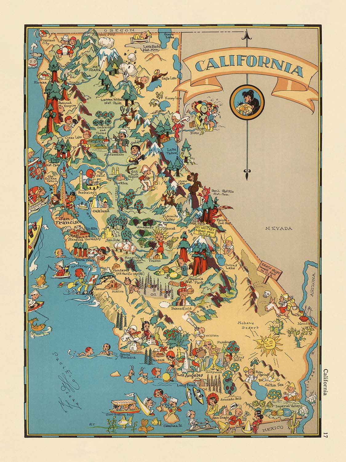


Carte picturale de la Californie par Ruth Taylor White, 1935: Los Angeles, San Francisco, Yosemite, Sierra Nevada, Hollywood
Achetez 2, obtenez 1 gratuit
Si vous ajoutez 2 articles à votre panier, vous pouvez ajouter un troisième produit gratuitement.
Cela fonctionne pour toutes les cartes et œuvres d'art, y compris les pièces personnalisées et sur mesure. Vous pouvez commander 3 de la même chose, ou 3 choses différentes.
Cela équivaut à une remise de 33 %, qui sera la plus grande remise disponible dans ma boutique cette année.
Veuillez profiter de l'offre et couvrir vos murs de belles cartes et œuvres d'art !
Contactez-moi si vous avez des questions.
-
![]() Handmade in Australia
Handmade in Australia

-
Free delivery &
usually dispatched next day
Dispatched next working day
Your map should be dispatched the next working day.
Express delivery is available at checkout.
If you need your order to arrive by a certain date, contact me and we can discuss your options.
Please note that personalised maps, and some larger framed maps can take longer to produce and deliver.
-
Complimentary gifting & design advice
ⓘ
Complimentary gifting & design advice
Available almost 24/7 on WhatsApp and email — we usually reply within minutes. We can help you:
- Choose a perfectly personalised gift
- Send a digital gift preview to the recipient
- Pick the ideal size for your wall
- Select the right finish and frame
Quick, friendly advice so you can order with confidence.
For last minute gifts, consider buying a digital gift card. We have over 5,000 maps and art prints to choose from.
-
90-day returns & 5-year guarantee
ⓘ
90 jours pour retourner et obtenir un remboursement
Les produits peuvent être retournés dans les 90 jours pour un remboursement complet, ou un échange contre un autre produit.
Pour les articles personnalisés et faits sur mesure, nous pouvons vous offrir un crédit en magasin ou une carte-cadeau non expirante, car nous ne pouvons pas revendre les commandes personnalisées.
Si vous avez des questions, contactez-nous. Pour plus d'informations, consultez notre politique de retours et d'échanges.

This is a museum-grade archival print from the original 1935 map — restored in our workshop and made to order on 220gsm archival matte paper or 400gsm artist's cotton canvas with pigment inks.
Professional framing & free personalisation available.
1. Choose a size
2. Frame & personalise your map
Make your map unique with framing, hand-drawn customisation, vintage ageing, pop art text, unique 3D styling and more.


Message cadeau & finition personnalisée

Si vous souhaitez ajouter un message cadeau, ou une finition (puzzle, panneau en aluminium, etc.) qui n'est pas disponible ici, veuillez le demander dans la "note de commande" lors de votre passage à la caisse.
Chaque commande est fabriquée sur mesure, donc si vous avez besoin d'ajuster légèrement la taille, ou d'imprimer sur un matériau inhabituel, faites-le nous savoir. Nous avons réalisé des milliers de commandes personnalisées au fil des ans, donc il n'y a (presque) rien que nous ne puissions gérer.
Vous pouvez également nous contacter avant de passer votre commande, si vous le souhaitez !

- Handmade locally. No import duty or tax
- FREE worldwide delivery
- 90-day returns & 5-year product guarantee
- Questions? WhatsApp me any time
Own a piece of history
7,000+ 5 star reviews


Entrez dans le monde vibrant de la Californie des années 1930 avec la carte picturale captivante, initialement intitulée "Californie," réalisée par la talentueuse Ruth Taylor White en 1935. Cette carte est plus qu'un simple rendu géographique—c'est une célébration du caractère régional de la Californie, rendue dans un style fantaisiste et visuellement frappant qui reflète l'optimisme et l'énergie créative de son époque. Les illustrations ludiques et les couleurs vives de la carte invitent les spectateurs à explorer l'État d'Or tel qu'il était imaginé dans la culture populaire, chaque comté et région prenant vie à travers des caricatures charmantes et des scènes iconiques.
Ruth Taylor White, la force créatrice derrière cette œuvre, était renommée pour sa capacité à allier art et cartographie, produisant des cartes aussi divertissantes qu'informatives. Ses cartes picturales sont devenues des artefacts culturels bien-aimés, capturant l'esprit des régions américaines à travers une lentille unique qui combinait humour, histoire et couleur locale. Dans cette carte de Californie, le talent de White brille à travers chaque détail, des vallées agricoles animées aux sommets dramatiques de la Sierra Nevada, chaque vignette soigneusement choisie pour refléter l'identité et le patrimoine de l'État.
Le design de la carte est un cours magistral dans le style pictural qui a prospéré au début du XXe siècle. Plutôt que de s'appuyer sur des conventions cartographiques strictes, l'approche de White est imaginative et narrative, utilisant des illustrations vibrantes pour mettre en évidence les industries, les monuments et les traditions culturelles qui ont défini la Californie dans les années 1930. Des trésors nationaux tels que les parcs nationaux de Yosemite et de Sequoia sont dépeints avec grandeur, tandis que la côte pacifique déborde d'activités maritimes et de plages ensoleillées. L'abondance agricole de la vallée centrale, les contreforts aurifères de la Sierra et les vignobles légendaires de Napa et Sonoma sont tous rendus avec éclat, offrant un voyage visuel délicieux à travers l'État.
Au-delà de son attrait esthétique, cette carte est un document historique fascinant. Elle capture un moment dans le temps où la Californie évoluait rapidement, façonnée par des vagues de migration, d'opportunités économiques et d'innovation culturelle. Les illustrations de la carte font référence à la ruée vers l'or, aux missions espagnoles, au patrimoine amérindien et à l'industrie cinématographique naissante à Hollywood, fournissant un récit stratifié du passé et du présent de l'État. Ces thèmes sont tissés harmonieusement dans le paysage, invitant les spectateurs à réfléchir aux diverses influences qui ont façonné l'identité unique de la Californie.
La représentation des villes et des villages sur la carte, de la métropole en plein essor de Los Angeles aux rues légendaires de San Francisco et au cœur agricole de Fresno, souligne la croissance dynamique et la diversité régionale de la Californie. Chaque établissement est niché parmi des caractéristiques locales distinctives—des derricks de pétrole au sud, des forêts de séquoias au nord, et des vergers d'agrumes dans les vallées ensoleillées—créant un tableau vivant qui célèbre à la fois la beauté naturelle et l'accomplissement humain. Cette carte n'est pas seulement un festin visuel mais aussi un témoignage de l'attrait durable et de la complexité de la Californie, en faisant un ajout précieux à toute collection de cartographie historique.
Villes et villages sur cette carte
- Los Angeles
- San Diego
- San Jose
- San Francisco
- Fresno
- Sacramento
- Long Beach
- Oakland
- Bakersfield
- Anaheim
- Santa Ana
- Riverside
- Stockton
- Chula Vista
- Irvine
- Fremont
- San Bernardino
- Modesto
- Oxnard
- Fontana
Caractéristiques et monuments notables
- Parc national de Yosemite (représenté avec des illustrations de chutes d'eau et de falaises de granit)
- Parc national de Séquoia (illustré avec des arbres géants)
- Mont Whitney (illustré comme le plus haut sommet des États-Unis contigus)
- La chaîne de montagnes Sierra Nevada (représentée le long de la partie est de l'État)
- L'océan Pacifique (bordant le bord occidental de la carte, avec des illustrations de navires et de vie marine)
- Scènes agricoles dans la vallée centrale (représentant des cultures et des travailleurs agricoles)
- Imagerie de l'exploitation de l'or dans les contreforts de la Sierra (référant à la ruée vers l'or en Californie)
- Vignobles et vinification dans la région de Napa/Sonoma
- Élevage de bétail dans les régions centrale et sud
- Citreraies dans le sud de la Californie
- Imagerie d'Hollywood (représentant l'industrie cinématographique)
- Surf et scènes de plage le long de la côte sud
- Missions (illustrées le long de l'historique El Camino Real)
- Pompes à pétrole dans la partie sud de l'État
- Forêts de séquoias dans la région côtière nord
- Raisins et vergers de fruits dans la vallée de San Joaquin
- Représentations de la vie et de la culture amérindiennes
- Illustrations de l'héritage et de l'influence espagnols
- Activités maritimes le long de la côte (pêche, expédition)
- Illustrations du paysage désertique dans le sud-est de la Californie
Contexte historique et de conception
- Créé par Ruth Taylor White en 1935, une cartographe picturale renommée célébrée pour son mélange d'art et de cartographie.
- Présente un style pictural fantaisiste, semblable à un dessin animé, typique des cartes des années 1930, mettant en avant le caractère régional et l'humour.
- Met en valeur des scènes stéréotypées et des images emblématiques représentatives de la culture, de l'économie et du paysage de la Californie durant les années 1930.
- Serre à la fois de représentation géographique et d'artéfact culturel, reflétant les tendances artistiques et les attitudes sociétales de son époque.
- Couvre l'ensemble de l'État de Californie, avec des frontières de comté et des régions notables illustrées de manière vivante et engageante.
- Fait partie d'une série plus large d'atlas pictural, capturant l'esprit et la diversité des régions américaines pour un public populaire.
- Offre un aperçu de l'histoire de la Californie, y compris des références à la ruée vers l'or, aux missions espagnoles et à l'essor d'Hollywood.
- Exemplifie le mouvement de la carte picturale, mêlant art et géographie à des fins éducatives et décoratives.
Veuillez vérifier les images pour vous assurer qu'une ville ou un lieu spécifique est montré sur cette carte. Vous pouvez également nous contacter et nous demander de vérifier la carte pour vous.
Cette carte a fière allure à toutes les tailles, mais je recommande toujours d'opter pour une taille plus grande si vous avez de l'espace. Ainsi, vous pouvez facilement distinguer tous les détails.
Cette carte est incroyable à des tailles allant jusqu'à 50 pouces (125 cm). Si vous recherchez une carte plus grande, veuillez nous contacter.
Le modèle dans les images de la liste tient la version 18x24 pouces (45x60 cm) de cette carte.
La cinquième image de la liste montre un exemple de mon service de personnalisation de carte.
Si vous recherchez quelque chose de légèrement différent, consultez ma collection des meilleures anciennes cartes pour voir si quelque chose d'autre attire votre attention.
Veuillez me contacter pour vérifier si un certain emplacement, monument ou caractéristique est montré sur cette carte.
Cela ferait un merveilleux cadeau d'anniversaire, de Noël, pour la fête des pères, pour un départ au travail, pour un anniversaire de mariage ou pour une pendaison de crémaillère pour quelqu'un des zones couvertes par cette carte.
Cette carte est disponible en tant qu'impression giclée sur du papier mat d'archives sans acide, ou vous pouvez l'acheter encadrée. Le cadre est un joli cadre noir simple qui convient à la plupart des esthétiques. Veuillez me contacter si vous souhaitez une couleur ou un matériau de cadre différent. Mes cadres sont en verre acrylique super clair de qualité musée (perspex/acrylite), qui est significativement moins réfléchissant que le verre, plus sûr, et arrivera toujours en parfait état.
This map is also available as a float framed canvas, sometimes known as a shadow gap framed canvas or canvas floater. The map is printed on artist's cotton canvas and then stretched over a handmade box frame. We then "float" the canvas inside a wooden frame, which is available in a range of colours (black, dark brown, oak, antique gold and white). This is a wonderful way to present a map without glazing in front. See some examples of float framed canvas maps and explore the differences between my different finishes.
For something truly unique, this map is also available in "Unique 3D", our trademarked process that dramatically transforms the map so that it has a wonderful sense of depth. We combine the original map with detailed topography and elevation data, so that mountains and the terrain really "pop". For more info and examples of 3D maps, check my Unique 3D page.
Pour la plupart des commandes, le délai de livraison est d'environ 3 jours ouvrables. Les produits personnalisés et sur mesure prennent plus de temps, car je dois faire la personnalisation et vous l'envoyer pour approbation, ce qui prend généralement 1 ou 2 jours.
Veuillez noter que les grandes commandes encadrées prennent généralement plus de temps à réaliser et à livrer.
Si vous avez besoin que votre commande arrive à une date précise, veuillez me contacter avant de passer votre commande afin que nous puissions trouver le meilleur moyen de nous assurer que vous receviez votre commande à temps.
J'imprime et encadre des cartes et des œuvres d'art dans 23 pays à travers le monde. Cela signifie que votre commande sera réalisée localement, ce qui réduit le temps de livraison et garantit qu'elle ne sera pas endommagée pendant le transport. Vous ne paierez jamais de droits de douane ou d'importation, et nous mettrons moins de CO2 dans l'air.
Toutes mes cartes et impressions artistiques sont bien emballées et envoyées dans un tube robuste si non encadrées, ou entourées de mousse si encadrées.
J'essaie d'envoyer toutes les commandes dans les 1 ou 2 jours suivant la réception de votre commande, bien que certains produits (comme les masques, les mugs et les sacs fourre-tout) puissent prendre plus de temps à réaliser.
Si vous choisissez Livraison Express lors du paiement, nous donnerons la priorité à votre commande et l'enverrons par un service de messagerie de 1 jour (Fedex, DHL, UPS, Parcelforce).
La livraison le lendemain est également disponible dans certains pays (États-Unis, Royaume-Uni, Singapour, Émirats Arabes Unis), mais veuillez essayer de commander tôt dans la journée afin que nous puissions l'envoyer à temps.
Lisez mon guide complet sur la livraison et la production locale
Mon cadre standard est un cadre en bois dur noir de style galerie. Il est simple et a un aspect assez moderne. Mon cadre standard mesure environ 20 mm (0,8 po) de large.
J'utilise de l'acrylique super clair (perspex/acrylite) pour le verre du cadre. C'est plus léger et plus sûr que le verre - et cela a meilleur aspect, car la réflexivité est plus faible.
Six couleurs de cadre standard sont disponibles gratuitement (noir, marron foncé, gris foncé, chêne, blanc et or antique). Des encadrements et montages/matelassages personnalisés sont disponibles si vous recherchez autre chose.
La plupart des cartes, œuvres d'art et illustrations sont également disponibles sous forme de toile encadrée. Nous utilisons une toile en coton mate (non brillante), que nous tendons sur un cadre en bois de boîte provenant de sources durables, puis nous 'flottions' la pièce à l'intérieur d'un cadre en bois. Le résultat final est assez beau, et il n'y a pas de vitrage qui gêne.
Tous les cadres sont fournis "prêts à accrocher", avec soit une corde, soit des supports à l'arrière. Les très grands cadres auront des plaques de suspension lourdes et/ou une latte de montage. Si vous avez des questions, veuillez nous contacter.
Voir quelques exemples de mes cartes encadrées et de cartes en toile encadrées.
Alternativement, je peux également fournir de vieilles cartes et œuvres d'art sur toile, sur panneau en mousse, en coton et d'autres matériaux.
Si vous souhaitez encadrer votre carte ou œuvre d'art vous-même, veuillez lire d'abord mon guide des tailles.
Certaines de mes anciennes cartes sont maintenant disponibles en tant que toiles encadrées. Veuillez me contacter si vous souhaitez commander une taille qui n'est pas disponible dans ma boutique.
Les anciennes cartes en toile sont une alternative intéressante aux cartes encadrées de manière conventionnelle. Selon vos goûts personnels et la décoration de votre pièce, les cartes en toile peuvent "se démarquer" un peu plus qu'une carte encadrée.
Mes cartes sont des reproductions de cartes originales de très haute qualité.
Je recherche des cartes originales et rares auprès de bibliothèques, de maisons de ventes aux enchères et de collections privées du monde entier, je les restaure dans mon atelier de Londres, puis j'utilise des encres et des imprimantes giclées spécialisées pour créer de magnifiques cartes encore plus belles que l'originale.
Mes cartes sont imprimées sur du papier d’archives mat (non brillant) sans acide qui semble de très haute qualité et ressemble presque à une carte. En termes techniques, le grammage/épaisseur du papier est de 10 mil/200 g/m². C'est parfait pour l'encadrement.
J’imprime avec des encres pigmentaires Epson ultrachrome giclée UV résistantes à la décoloration – certaines des meilleures encres que vous puissiez trouver.
je peux aussi faire cartes sur toile, chiffon en coton et autres matériaux exotiques.
En savoir plus sur Unique Maps Co..
Personnalisation de la carte
Si vous recherchez le cadeau parfait pour un anniversaire ou une pendaison de crémaillère, je peux personnaliser votre carte pour la rendre vraiment unique. Par exemple, je peux ajouter un court message, mettre en évidence un lieu important ou ajouter les armoiries de votre famille.
Les options sont presque infinies. S'il vous plaît voir mon page de personnalisation de la carte pour quelques merveilleux exemples de ce qui est possible.
Pour commander une carte personnalisée, sélectionnez « personnaliser votre carte » avant de l'ajouter à votre panier.
Entrer en contact si vous recherchez des personnalisations et des personnalisations plus complexes.
Vieillissement de la carte
Au fil des ans, des clients m'ont demandé des centaines de fois s'ils pouvaient acheter une carte qui semble uniforme. plus vieux.
Eh bien, vous pouvez désormais le faire en sélectionnant Aged avant d'ajouter une carte à votre panier.
Toutes les photos de produits que vous voyez sur cette page montrent la carte dans sa forme originale. Voilà à quoi ressemble la carte aujourd'hui.
Si vous sélectionnez Vieilli, je vieillirai votre carte à la main, en utilisant un processus spécial et unique développé au cours d'années d'étude de cartes anciennes, de discussions avec des chercheurs pour comprendre la chimie du vieillissement du papier, et bien sûr... beaucoup de pratique !
Si vous n'êtes pas sûr, respectez la couleur originale de la carte. Si vous voulez quelque chose d'un peu plus sombre et plus vieux à la recherche, optez pour Aged.
Si vous n'êtes pas satisfait de votre commande pour une raison quelconque, contactez-moi pour un remboursement sans conditions. Veuillez consulter notre politique de retours et de remboursements pour plus d'informations.
Je suis très confiant que vous aimerez votre carte restaurée ou votre impression artistique. Je fais cela depuis 1984. Je suis un vendeur Etsy 5 étoiles. J'ai vendu des dizaines de milliers de cartes et d'impressions artistiques et j'ai plus de 5 000 vrais avis 5 étoiles.
J'utilise un processus unique pour restaurer des cartes et des œuvres d'art qui est extrêmement chronophage et exigeant en main-d'œuvre. Trouver les cartes et illustrations originales peut prendre des mois. J'utilise une technologie de pointe et incroyablement coûteuse pour les numériser et les restaurer. En conséquence, je garantis que mes cartes et impressions artistiques sont d'une qualité supérieure - c'est pourquoi je peux offrir un remboursement sans conditions.
Presque toutes mes cartes et impressions artistiques ont l'air incroyables en grandes tailles (200 cm, 6,5 pieds+) et je peux également les encadrer et vous les livrer, via un transporteur spécial surdimensionné. Contactez-moi pour discuter de vos besoins spécifiques.
Or try searching for something!


