


Manhattan: The Great Saunter, Mappa del Percorso della Unique Maps Co. e Chase, 1939: Personalizzabile, Central Park, Statua della Libertà, Empire State Building, Harlem
L’offerta del Collezionista
Scegli due opere idonee e ricevi il 20% di sconto su entrambe. Scegline tre e quella al prezzo più basso è in omaggio, con un risparmio massimo del 33%.
Abbina liberamente mappe standard idonee e stampe d’arte fine art. Non è richiesto alcun codice; l’offerta viene applicata automaticamente al checkout.
Sono incluse le configurazioni standard su ordinazione. Sono esclusi formati su misura, design personalizzati e lavori su commissione.
Hai bisogno di consegne a indirizzi diversi? Contattaci prima di effettuare l’ordine.L’offerta del Collezionista
Scegli due opere idonee e ricevi il 20% di sconto su entrambe. Scegline tre e quella al prezzo più basso è in omaggio, con un risparmio massimo del 33%.
Abbina liberamente mappe standard idonee e stampe d’arte fine art. Non è richiesto alcun codice; l’offerta viene applicata automaticamente al checkout.
Sono incluse le configurazioni standard su ordinazione. Sono esclusi formati su misura, design personalizzati e lavori su commissione.
Hai bisogno di consegne a indirizzi diversi? Contattaci prima di effettuare l’ordine. Progettato a Londra Prodotto in Australia
Progettato a Londra • Prodotto in Australia
Progettato a Londra Prodotto in Australia
Progettato a Londra • Prodotto in Australia

Restaurata dalla mappa originale del 2025 e stampata in qualità museale. Leggi la storia dietro questa mappa
Choose your size
Choose your finish


(Maggiori informazioni)
Gift message & custom finish

If you want to add a gift message, or a finish (jigsaw, aluminium board, etc.) that is not available here, please request it in the "order note" when you check out.
Every order is custom made, so if you need the size adjusted slightly, or printed on an unusual material, just let us know. We've done thousands of custom orders over the years, so there's (almost) nothing we can't manage.
You can also contact us before you order, if you prefer!

- Prodotto localmente. Consegna sicura
- Nessun dazio o costo nascosto
- Serve aiuto? Chiamaci o messaggio su WhatsApp
Own a piece of history
8,000+ five-star reviews


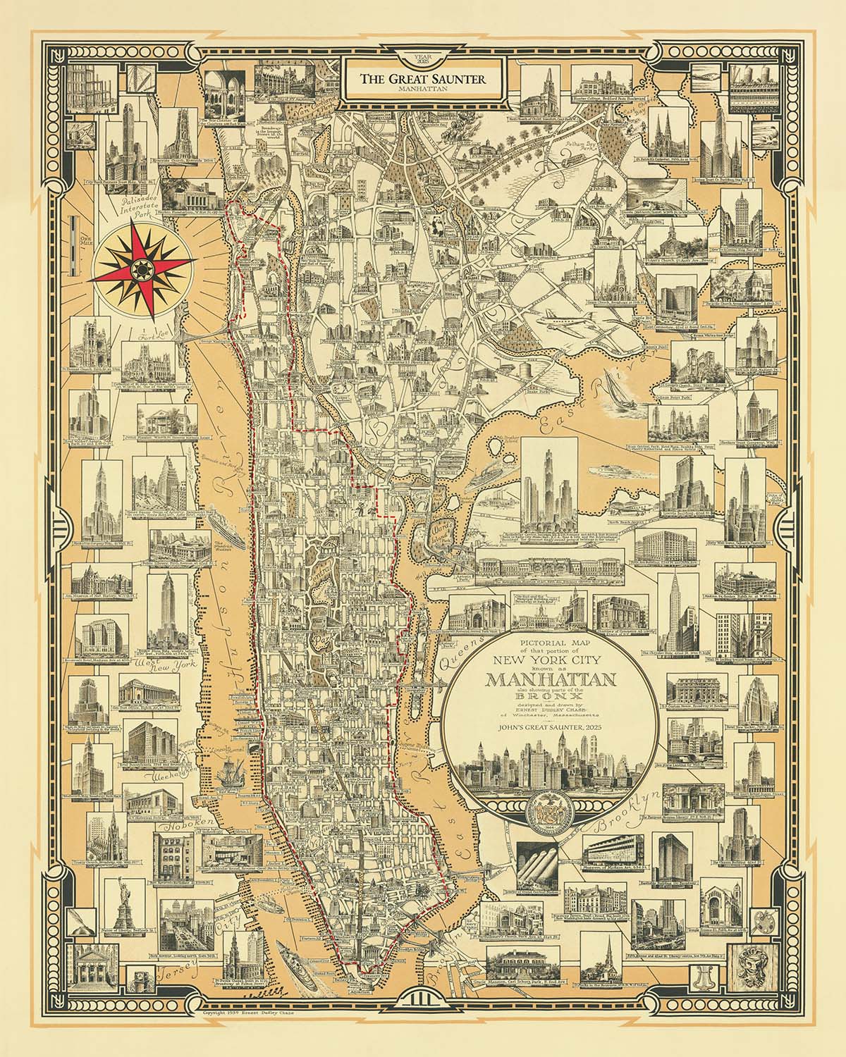
“Manhattan: The Great Saunter” è una mappa della città sorprendente che cattura elegantemente la costa di 32 miglia di Manhattan, invitando gli...
Continua a leggere“Manhattan: The Great Saunter” è una mappa della città sorprendente che cattura elegantemente la costa di 32 miglia di Manhattan, invitando gli spettatori a tracciare il leggendario percorso del Great Saunter in dettagli squisiti. Il titolo originale della mappa, un omaggio sia all'isola iconica che alla celebre escursione urbana, segnala immediatamente la sua duplice natura sia come artefatto storico che come tributo vivente al lungomare in continua evoluzione di New York.
Questa mappa è una lettera d'amore ai quartieri di Manhattan, ciascuno rappresentato con cura e chiarezza. Dalla vasta area verde di Inwood all'estremità settentrionale dell'isola fino alle strade affollate del Financial District all'estremità meridionale, la mappa invita a esplorare enclave storiche come Harlem, Washington Heights, Greenwich Village, SoHo e Tribeca. La delineazione attenta di questi quartieri, intrecciata con il percorso del Great Saunter, offre una rara prospettiva panoramica delle diverse comunità di Manhattan e della loro relazione con il lungomare—una relazione plasmata da secoli di commercio, cultura e rinnovamento urbano.
Lo stile pittorico della mappa porta vividamente in vita i monumenti famosi di Manhattan. La Statua della Libertà e Ellis Island si ergono a sentinella all'estremità meridionale, mentre l'Empire State Building, il Chrysler Building e il One World Trade Center svettano maestosi sopra il panorama urbano. La Tomba di Grant, The Cloisters e il giocoso Little Red Lighthouse sono rappresentati con un livello di dettaglio che invita a uno studio e a un'ammirazione ravvicinati. Ogni illustrazione non è semplicemente decorativa, ma un promemoria della storia stratificata della città, dei suoi trionfi architettonici e del segno indelebile che questi luoghi hanno lasciato sull'immaginario collettivo.
L'acqua è un personaggio centrale in questa narrativa cartografica. La rappresentazione elegante della mappa dei fiumi Hudson, Harlem ed East incornicia Manhattan sia come isola che come crocevia, plasmata dal flusso e riflusso delle maree e del tempo. Il percorso del Great Saunter, che abbraccia la costa, attira l'attenzione sui parchi lungomare rivitalizzati della città—Central Park, Riverside Park, Fort Tryon Park, East River Park, Battery Park e molti altri. Questi spazi verdi, un tempo trascurati o inaccessibili, ora formano un nastro quasi continuo di terreno pubblico, testimonianza di decenni di advocacy e dell'impegno duraturo della città per la vita pubblica.
Ernest Dudley Chase, il creatore originale della mappa, era rinomato per le sue mappe pittoriche che mescolavano accuratezza con arte, rendendo ogni opera una festa per gli occhi e per l'intelletto. Il suo lascito è onorato ed esteso da The Unique Maps Co., i cui abbellimenti del 2025 evidenziano la storia in corso del lungomare di Manhattan e lo spirito comunitario del Great Saunter. Questa mappa è più di un aiuto alla navigazione; è una celebrazione della resilienza, della diversità e della capacità illimitata di reinvenzione di New York—qualità che la rendono un'aggiunta essenziale a qualsiasi collezione di mappe storiche della città.
Strade e vie su questa mappa
- 1st Avenue
- 2nd Avenue
- 3rd Avenue
- 5th Avenue
- 6th Avenue
- 7th Avenue
- 8th Avenue
- 9th Avenue
- 10th Avenue
- 11th Avenue
- 12th Avenue
- Amsterdam Avenue
- Avenue A
- Avenue B
- Avenue C
- Avenue D
- Broadway
- Central Park West
- Columbus Avenue
- Edgecombe Avenue
- Fort Washington Avenue
- Lenox Avenue
- Lexington Avenue
- Madison Avenue
- Park Avenue
- Riverside Drive
- St. Nicholas Avenue
- St. Nicholas Terrace
- West End Avenue
- York Avenue
Caratteristiche e Luoghi di Interesse
- Il percorso del Great Saunter chiaramente segnato, che circonda la costa di Manhattan
- Central Park
- Riverside Park
- Fort Tryon Park
- Inwood Hill Park
- East River Park
- Battery Park
- Carl Schurz Park
- Hudson River Park
- Harlem River Park
- Morningside Park
- St. Nicholas Park
- Promenade e moli lungo il waterfront
- La Statua della Libertà (illustrata, al largo della punta meridionale)
- Ellis Island (illustrata, al largo della punta meridionale)
- Il Palazzo delle Nazioni Unite (illustrato)
- Il Palazzo Empire State (illustrato)
- Il Palazzo Chrysler (illustrato)
- One World Trade Center (illustrato)
- La Tomba di Grant (illustrata)
- Il Piccolo Faro Rosso (illustrato)
- I Cloisters (illustrati)
- Harlem
- Washington Heights
- Inwood
- Upper West Side
- Upper East Side
- Midtown
- Lower East Side
- Battery Park City
- Tribeca
- Greenwich Village
- Chelsea
- SoHo
- Chinatown
- Financial District
- Fiume Hudson
- Fiume Harlem
- Fiume East
- Ponte George Washington
- Ponte di Brooklyn
- Ponte di Manhattan
- Ponte di Williamsburg
- Ponte Queensboro (59th Street)
- Ponte Triborough (RFK)
- Ponte Henry Hudson
- Ponte Washington
- Rose dei venti decorativa
- Vignette di figure che camminano e partecipanti al Saunter
- Cartouche decorativa del titolo
Contesto storico e di design
- Nome della mappa: Manhattan: The Great Saunter
- Rappresenta il Great Saunter, un percorso di 32 miglia attorno alla costa di Manhattan
- Cartografo/editore: The Unique Maps Co., 2025
- Mappa base originariamente creata da Ernest Dudley Chase nel 1939, un rinomato cartografo noto per il suo stile pittorico
- Aggiornata nel 2025 con il percorso del Great Saunter e tocchi artistici moderni
- Mappa tematica e pittorica della città, che fonde elementi vintage e contemporanei
- Si concentra sull'escursionismo urbano, l'accesso pubblico al waterfront e parchi e promenade interconnessi
- Celebra l'evento annuale del Great Saunter, riconosciuto dal Consiglio di New York come il Great Saunter Day
- Mettere in evidenza la trasformazione del waterfront di Manhattan, plasmata da advocacy dal 1982 per l'accesso pubblico
- Combina la cartografia storica con la cultura urbana moderna e l'ambientalismo
Si prega di controllare attentamente le immagini per assicurarsi che una specifica città o luogo sia mostrato su questa mappa. Puoi anche contattarci e chiedere di controllare la mappa per te.
Questa mappa appare fantastica in tutte le dimensioni, ma consiglio sempre di optare per una dimensione più grande se hai spazio. In questo modo puoi facilmente distinguere tutti i dettagli.
Questa mappa appare incredibile in dimensioni fino a 90in (230cm). Se stai cercando una mappa più grande, per favore contattaci.
Il modello nelle immagini dell'elenco tiene la versione di questa mappa 16x20in (40x50cm).
La quinta immagine dell'elenco mostra un esempio del mio servizio di personalizzazione delle mappe.
Se stai cercando qualcosa di leggermente diverso, dai un'occhiata alla mia collezione delle migliori mappe antiche per vedere se qualcosa attira la tua attenzione.
Per favore contattami per verificare se una certa posizione, punto di riferimento o caratteristica è mostrata su questa mappa.
Questo sarebbe un meraviglioso regalo di compleanno, Natale, Festa del Papà, addio al lavoro, anniversario o inaugurazione della casa per qualcuno delle aree coperte da questa mappa.
Questa mappa è disponibile come stampa giclée su carta opaca archiviata senza acidi, oppure puoi acquistarla incorniciata. La cornice è una bella e semplice cornice nera che si adatta alla maggior parte degli stili. Per favore, mettiti in contatto se desideri un colore o un materiale della cornice diverso. Le mie cornici sono dotate di un vetro acrilico super chiaro di qualità museale (perspex/acrylite), che è significativamente meno riflettente rispetto al vetro, più sicuro e arriverà sempre in perfette condizioni.
This map is also available as a float framed canvas, sometimes known as a shadow gap framed canvas or canvas floater. The map is printed on artist's cotton canvas and then stretched over a handmade box frame. We then "float" the canvas inside a wooden frame, which is available in a range of colours (black, dark brown, oak, antique gold and white). This is a wonderful way to present a map without glazing in front. See some examples of float framed canvas maps and explore the differences between my different finishes.
For something truly unique, this map is also available in "Unique 3D", our trademarked process that dramatically transforms the map so that it has a wonderful sense of depth. We combine the original map with detailed topography and elevation data, so that mountains and the terrain really "pop". For more info and examples of 3D maps, check my Unique 3D page.
“Manhattan: The Great Saunter” è una mappa della città sorprendente che cattura elegantemente la costa di 32 miglia di Manhattan, invitando gli spettatori a tracciare il leggendario percorso del Great Saunter in dettagli squisiti. Il titolo originale della mappa, un omaggio sia all'isola iconica che alla celebre escursione urbana, segnala immediatamente la sua duplice natura sia come artefatto storico che come tributo vivente al lungomare in continua evoluzione di New York.
Questa mappa è una lettera d'amore ai quartieri di Manhattan, ciascuno rappresentato con cura e chiarezza. Dalla vasta area verde di Inwood all'estremità settentrionale dell'isola fino alle strade affollate del Financial District all'estremità meridionale, la mappa invita a esplorare enclave storiche come Harlem, Washington Heights, Greenwich Village, SoHo e Tribeca. La delineazione attenta di questi quartieri, intrecciata con il percorso del Great Saunter, offre una rara prospettiva panoramica delle diverse comunità di Manhattan e della loro relazione con il lungomare—una relazione plasmata da secoli di commercio, cultura e rinnovamento urbano.
Lo stile pittorico della mappa porta vividamente in vita i monumenti famosi di Manhattan. La Statua della Libertà e Ellis Island si ergono a sentinella all'estremità meridionale, mentre l'Empire State Building, il Chrysler Building e il One World Trade Center svettano maestosi sopra il panorama urbano. La Tomba di Grant, The Cloisters e il giocoso Little Red Lighthouse sono rappresentati con un livello di dettaglio che invita a uno studio e a un'ammirazione ravvicinati. Ogni illustrazione non è semplicemente decorativa, ma un promemoria della storia stratificata della città, dei suoi trionfi architettonici e del segno indelebile che questi luoghi hanno lasciato sull'immaginario collettivo.
L'acqua è un personaggio centrale in questa narrativa cartografica. La rappresentazione elegante della mappa dei fiumi Hudson, Harlem ed East incornicia Manhattan sia come isola che come crocevia, plasmata dal flusso e riflusso delle maree e del tempo. Il percorso del Great Saunter, che abbraccia la costa, attira l'attenzione sui parchi lungomare rivitalizzati della città—Central Park, Riverside Park, Fort Tryon Park, East River Park, Battery Park e molti altri. Questi spazi verdi, un tempo trascurati o inaccessibili, ora formano un nastro quasi continuo di terreno pubblico, testimonianza di decenni di advocacy e dell'impegno duraturo della città per la vita pubblica.
Ernest Dudley Chase, il creatore originale della mappa, era rinomato per le sue mappe pittoriche che mescolavano accuratezza con arte, rendendo ogni opera una festa per gli occhi e per l'intelletto. Il suo lascito è onorato ed esteso da The Unique Maps Co., i cui abbellimenti del 2025 evidenziano la storia in corso del lungomare di Manhattan e lo spirito comunitario del Great Saunter. Questa mappa è più di un aiuto alla navigazione; è una celebrazione della resilienza, della diversità e della capacità illimitata di reinvenzione di New York—qualità che la rendono un'aggiunta essenziale a qualsiasi collezione di mappe storiche della città.
Strade e vie su questa mappa
- 1st Avenue
- 2nd Avenue
- 3rd Avenue
- 5th Avenue
- 6th Avenue
- 7th Avenue
- 8th Avenue
- 9th Avenue
- 10th Avenue
- 11th Avenue
- 12th Avenue
- Amsterdam Avenue
- Avenue A
- Avenue B
- Avenue C
- Avenue D
- Broadway
- Central Park West
- Columbus Avenue
- Edgecombe Avenue
- Fort Washington Avenue
- Lenox Avenue
- Lexington Avenue
- Madison Avenue
- Park Avenue
- Riverside Drive
- St. Nicholas Avenue
- St. Nicholas Terrace
- West End Avenue
- York Avenue
Caratteristiche e Luoghi di Interesse
- Il percorso del Great Saunter chiaramente segnato, che circonda la costa di Manhattan
- Central Park
- Riverside Park
- Fort Tryon Park
- Inwood Hill Park
- East River Park
- Battery Park
- Carl Schurz Park
- Hudson River Park
- Harlem River Park
- Morningside Park
- St. Nicholas Park
- Promenade e moli lungo il waterfront
- La Statua della Libertà (illustrata, al largo della punta meridionale)
- Ellis Island (illustrata, al largo della punta meridionale)
- Il Palazzo delle Nazioni Unite (illustrato)
- Il Palazzo Empire State (illustrato)
- Il Palazzo Chrysler (illustrato)
- One World Trade Center (illustrato)
- La Tomba di Grant (illustrata)
- Il Piccolo Faro Rosso (illustrato)
- I Cloisters (illustrati)
- Harlem
- Washington Heights
- Inwood
- Upper West Side
- Upper East Side
- Midtown
- Lower East Side
- Battery Park City
- Tribeca
- Greenwich Village
- Chelsea
- SoHo
- Chinatown
- Financial District
- Fiume Hudson
- Fiume Harlem
- Fiume East
- Ponte George Washington
- Ponte di Brooklyn
- Ponte di Manhattan
- Ponte di Williamsburg
- Ponte Queensboro (59th Street)
- Ponte Triborough (RFK)
- Ponte Henry Hudson
- Ponte Washington
- Rose dei venti decorativa
- Vignette di figure che camminano e partecipanti al Saunter
- Cartouche decorativa del titolo
Contesto storico e di design
- Nome della mappa: Manhattan: The Great Saunter
- Rappresenta il Great Saunter, un percorso di 32 miglia attorno alla costa di Manhattan
- Cartografo/editore: The Unique Maps Co., 2025
- Mappa base originariamente creata da Ernest Dudley Chase nel 1939, un rinomato cartografo noto per il suo stile pittorico
- Aggiornata nel 2025 con il percorso del Great Saunter e tocchi artistici moderni
- Mappa tematica e pittorica della città, che fonde elementi vintage e contemporanei
- Si concentra sull'escursionismo urbano, l'accesso pubblico al waterfront e parchi e promenade interconnessi
- Celebra l'evento annuale del Great Saunter, riconosciuto dal Consiglio di New York come il Great Saunter Day
- Mettere in evidenza la trasformazione del waterfront di Manhattan, plasmata da advocacy dal 1982 per l'accesso pubblico
- Combina la cartografia storica con la cultura urbana moderna e l'ambientalismo
Si prega di controllare attentamente le immagini per assicurarsi che una specifica città o luogo sia mostrato su questa mappa. Puoi anche contattarci e chiedere di controllare la mappa per te.
Questa mappa appare fantastica in tutte le dimensioni, ma consiglio sempre di optare per una dimensione più grande se hai spazio. In questo modo puoi facilmente distinguere tutti i dettagli.
Questa mappa appare incredibile in dimensioni fino a 90in (230cm). Se stai cercando una mappa più grande, per favore contattaci.
Il modello nelle immagini dell'elenco tiene la versione di questa mappa 16x20in (40x50cm).
La quinta immagine dell'elenco mostra un esempio del mio servizio di personalizzazione delle mappe.
Se stai cercando qualcosa di leggermente diverso, dai un'occhiata alla mia collezione delle migliori mappe antiche per vedere se qualcosa attira la tua attenzione.
Per favore contattami per verificare se una certa posizione, punto di riferimento o caratteristica è mostrata su questa mappa.
Questo sarebbe un meraviglioso regalo di compleanno, Natale, Festa del Papà, addio al lavoro, anniversario o inaugurazione della casa per qualcuno delle aree coperte da questa mappa.
Questa mappa è disponibile come stampa giclée su carta opaca archiviata senza acidi, oppure puoi acquistarla incorniciata. La cornice è una bella e semplice cornice nera che si adatta alla maggior parte degli stili. Per favore, mettiti in contatto se desideri un colore o un materiale della cornice diverso. Le mie cornici sono dotate di un vetro acrilico super chiaro di qualità museale (perspex/acrylite), che è significativamente meno riflettente rispetto al vetro, più sicuro e arriverà sempre in perfette condizioni.
This map is also available as a float framed canvas, sometimes known as a shadow gap framed canvas or canvas floater. The map is printed on artist's cotton canvas and then stretched over a handmade box frame. We then "float" the canvas inside a wooden frame, which is available in a range of colours (black, dark brown, oak, antique gold and white). This is a wonderful way to present a map without glazing in front. See some examples of float framed canvas maps and explore the differences between my different finishes.
For something truly unique, this map is also available in "Unique 3D", our trademarked process that dramatically transforms the map so that it has a wonderful sense of depth. We combine the original map with detailed topography and elevation data, so that mountains and the terrain really "pop". For more info and examples of 3D maps, check my Unique 3D page.
Many of our maps and art prints are chosen as thoughtful gifts for homes, offices, studies and meaningful places.
Choose a framed option for the easiest ready-to-hang gift, or choose an unframed print if the recipient may prefer to select their own frame.
We make orders locally in 23 countries around the world, so gifts can often be produced close to the recipient. This helps them arrive faster, travel more safely, and avoid customs or import duty surprises.
- We can deliver directly to the recipient
- Framed pieces arrive ready to hang
- Unframed prints are carefully packed in a strong protective tube
- Almost every order is made locally, for faster, safer gifting
- 90-day returns give the recipient time to decide
If you are not sure what to choose, please contact us. We can help you pick the right map, size, finish or delivery option.
Most orders are made locally and delivered in around 2–3 working days, depending on the product, size and destination.
We print and frame maps and artwork in 23 countries around the world, so your order is usually made close to you or your recipient. That means faster delivery, less time in transit, and no customs or import duty surprises.
Personalised and customised pieces usually take an extra 1–2 working days, because we prepare your design and send it to you for approval before printing.
Very large framed orders can take a little longer, as they need extra care in production and delivery.
Every order is carefully packaged: unframed prints are sent in a strong protective tube, while framed pieces are securely packed with protective materials around the frame.
If you need your order by a particular date, please contact us before ordering. We’ll check the best production route and delivery option for your location.
Express delivery is available at checkout for most countries. Next-day delivery is available in the UK, US, Singapore and the UAE.
Your order is covered by our 90-day returns policy and 10-year guarantee.
Our standard frame is a gallery-style black ash hardwood frame, with a simple, modern look. It is approximately 20mm (0.8in) wide. You can also view some lovely customer photos of framed maps and art.
We use super-clear acrylic glazing, also known as Perspex or Acrylite, instead of traditional glass. It is lighter, safer, and has lower reflectivity, giving the artwork a clearer, cleaner appearance.
Six standard frame colours are available at no extra cost: black, dark brown, dark grey, oak, white, and antique gold. Custom framing and mounting/matting is also available for customers looking for something more specific.
Most maps, art prints, and illustrations are also available as a framed canvas. We use matte cotton canvas, stretch it over a sustainably sourced wooden box frame, and then float the piece within a wooden outer frame. The finished result is beautifully presented, with no glazing between you and the artwork.
All frames are supplied ready to hang, with either string or brackets fitted to the back. Very large frames will include heavy-duty hanging plates and/or a mounting baton. If you have any questions, please get in touch.
We can also supply old maps and artwork on canvas, foam board, cotton rag, and other materials.
If you would prefer to frame your map or artwork yourself, please read our size guide before ordering.
My maps are extremely high quality reproductions of original maps.
I source original, rare maps from libraries, auction houses and private collections around the world, restore them at my London workshop, and then use specialist giclée inks and printers to create beautiful maps that look even better than the original.
My maps are printed on acid-free archival matte (not glossy) paper that feels very high quality and almost like card. In technical terms the paper weight/thickness is 10mil/200gsm. It's perfect for framing.
I print with Epson ultrachrome giclée UV fade resistant pigment inks - some of the best inks you can find.
I can also make maps on canvas, cotton rag and other exotic materials.
Learn more about The Unique Maps Co.
Map personalisation
If you're looking for the perfect anniversary or housewarming gift, I can personalise your map to make it truly unique. For example, I can add a short message, or highlight an important location, or add your family's coat of arms.
The options are almost infinite. Please see my map personalisation page for some wonderful examples of what's possible.
To order a personalised map, select "personalise your map" before adding it to your basket.
Get in touch if you're looking for more complex customisations and personalisations.
Map ageing
I have been asked hundreds of times over the years by customers if they could buy a map that looks even older.
Well, now you can, by selecting Aged before you add a map to your basket.
All the product photos you see on this page show the map in its Original form. This is what the map looks like today.
If you select Aged, I will age your map by hand, using a special and unique process developed through years of studying old maps, talking to researchers to understand the chemistry of aging paper, and of course... lots of practice!
If you're unsure, stick to the Original colour of the map. If you want something a bit darker and older looking, go for Aged.
Se non sei soddisfatto del tuo ordine per qualsiasi motivo, contattami per un rimborso senza problemi. Si prega di consultare la nostra politica di reso e rimborso per ulteriori informazioni.
Sono molto sicuro che ti piacerà la tua mappa restaurata o la stampa d'arte. Lo faccio dal 1984. Sono un venditore Etsy a 5 stelle. Ho venduto decine di migliaia di mappe e stampe d'arte e ho oltre 5.000 recensioni reali a 5 stelle.
Utilizzo un processo unico per restaurare mappe e opere d'arte che richiede molto tempo e lavoro. Trovare le mappe e le illustrazioni originali può richiedere mesi. Utilizzo tecnologia all'avanguardia e incredibilmente costosa per scannerizzare e restaurarle. Di conseguenza, garantisco che le mie mappe e stampe d'arte siano superiori alle altre - ecco perché posso offrire un rimborso senza problemi.
Quasi tutte le mie mappe e stampe d'arte sembrano fantastiche a grandi dimensioni (200 cm, 6,5 piedi+) e posso anche incorniciarle e consegnarle a te, tramite un corriere speciale per oggetti di grandi dimensioni. Contattami per discutere delle tue esigenze specifiche.
Or try searching for something!


