


Vecchia mappa Birdseye di New York e Brooklyn di Bachmann, 1851: Central Park, The Battery, Brooklyn, East River, Hudson River
L’offerta del Collezionista
Scegli due opere idonee e ricevi il 20% di sconto su entrambe. Scegline tre e quella al prezzo più basso è in omaggio, con un risparmio massimo del 33%.
Abbina liberamente mappe standard idonee e stampe d’arte fine art. Non è richiesto alcun codice; l’offerta viene applicata automaticamente al checkout.
Sono incluse le configurazioni standard su ordinazione. Sono esclusi formati su misura, design personalizzati e lavori su commissione.
Hai bisogno di consegne a indirizzi diversi? Contattaci prima di effettuare l’ordine.L’offerta del Collezionista
Scegli due opere idonee e ricevi il 20% di sconto su entrambe. Scegline tre e quella al prezzo più basso è in omaggio, con un risparmio massimo del 33%.
Abbina liberamente mappe standard idonee e stampe d’arte fine art. Non è richiesto alcun codice; l’offerta viene applicata automaticamente al checkout.
Sono incluse le configurazioni standard su ordinazione. Sono esclusi formati su misura, design personalizzati e lavori su commissione.
Hai bisogno di consegne a indirizzi diversi? Contattaci prima di effettuare l’ordine. Progettato a Londra Prodotto in Australia
Progettato a Londra • Prodotto in Australia
Progettato a Londra Prodotto in Australia
Progettato a Londra • Prodotto in Australia

Restaurata dalla mappa originale del 1851 e stampata in qualità museale. Leggi la storia dietro questa mappa
Choose your size
Choose your finish


(Maggiori informazioni)
Gift message & custom finish

If you want to add a gift message, or a finish (jigsaw, aluminium board, etc.) that is not available here, please request it in the "order note" when you check out.
Every order is custom made, so if you need the size adjusted slightly, or printed on an unusual material, just let us know. We've done thousands of custom orders over the years, so there's (almost) nothing we can't manage.
You can also contact us before you order, if you prefer!

- Prodotto localmente. Consegna sicura
- Nessun dazio o costo nascosto
- Serve aiuto? Chiamaci o messaggio su WhatsApp
Own a piece of history
8,000+ five-star reviews


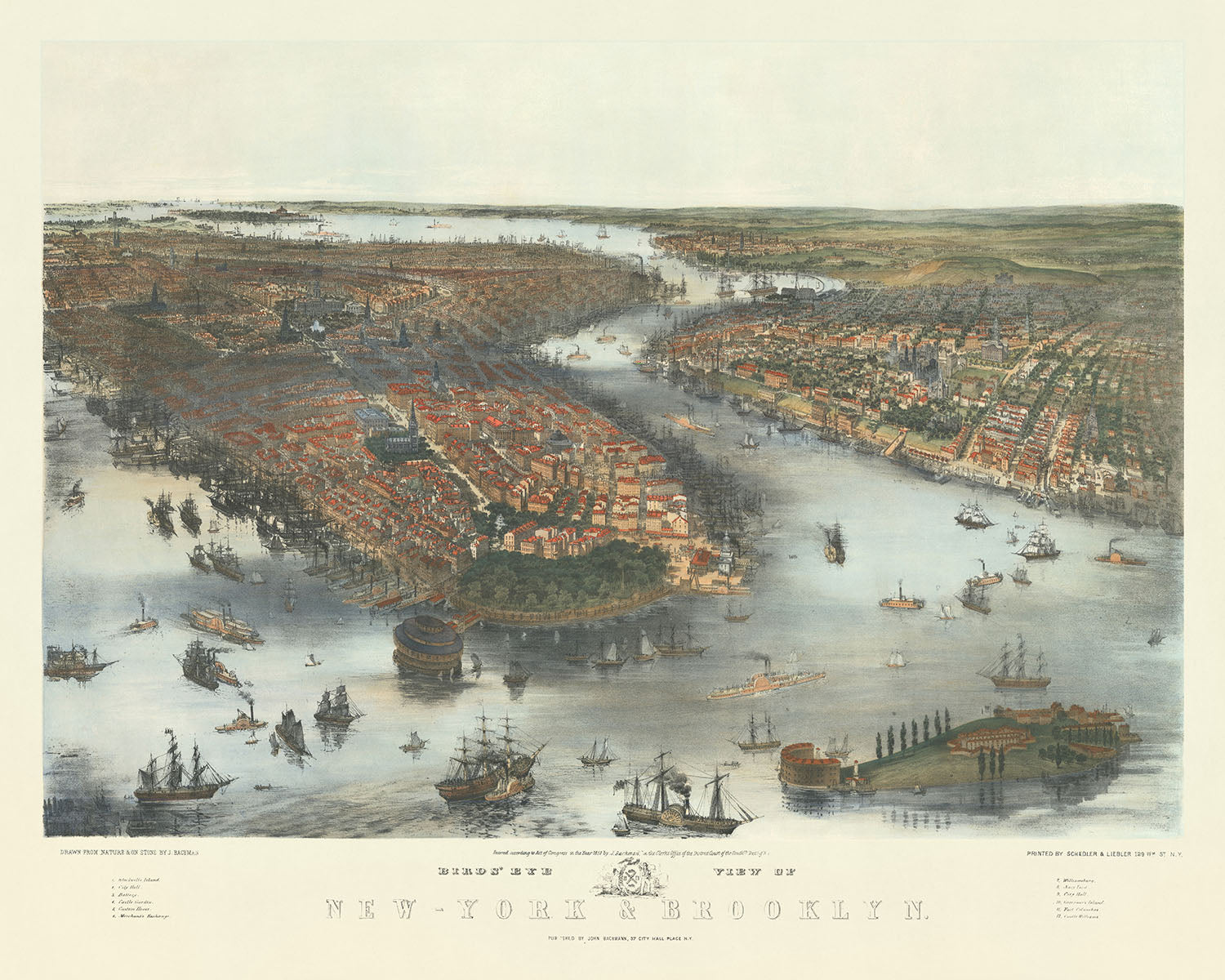
Immergiti nella grandezza storica della New York di metà Ottocento con il Bird's Eye View of New-York & Brooklyn, una litografia meticolosamente...
Continua a leggereImmergiti nella grandezza storica della New York di metà Ottocento con il Bird's Eye View of New-York & Brooklyn, una litografia meticolosamente colorata a mano dal rinomato John Bachmann. Creata nel 1851, questa mappa offre una rara prospettiva aerea che mette in mostra i paesaggi urbani in espansione di New York e Brooklyn. In un periodo in cui le città stavano vivendo una rapida crescita e trasformazione, l'opera di Bachmann cattura l'essenza dell'espansione urbana, accostando le aree densamente popolate ai rimanenti appezzamenti di terra agricola. Questo pezzo si distingue non solo per il suo merito artistico, ma anche come un documento significativo dello sviluppo urbano, fornendo una finestra sul passato che evidenzia l'evoluzione di queste città iconiche.
John Bachmann, un litografo tedesco-americano, si stabilì a New York nel 1836 e divenne rapidamente noto per le sue mappe in prospettiva a volo d'uccello. Il suo approccio unico alla cartografia, che combina accuratezza dettagliata con un tocco artistico, rende il suo lavoro molto ricercato da collezionisti e storici. Il Bird's Eye View of New-York & Brooklyn è una testimonianza del talento di Bachmann e della sua capacità di trasmettere la vivacità della vita cittadina. Dalle vivaci banchine di Brooklyn Heights all'emergente skyline di Lower Manhattan, la mappa di Bachmann è un'illustrazione vibrante del paesaggio urbano di New York City, rendendola un possesso prezioso per chiunque sia interessato alla storia delle città americane.
La mappa è ricca di dettagli, presentando quartieri, punti di riferimento e corsi d'acqua notevoli che definiscono New York e Brooklyn. Central Park, ancora nella sua infanzia, accenna all'oasi verde che sarebbe diventata nel mezzo dell'espansione urbana. The Battery, Castle Clinton e Governor's Island sono mostrati in modo prominente, segnando l'importanza strategica del porto di New York. Brooklyn mostra i suoi primi segni di urbanizzazione, con Williamsburg e Brooklyn Heights disegnati in notevole dettaglio. La rappresentazione della mappa dell'East River, dell'Hudson River e dell'Hudson River non solo evidenzia i confini naturali di queste città, ma anche il ruolo cruciale che i corsi d'acqua hanno giocato nel loro sviluppo e nella loro economia.
Oltre alla sua accuratezza geografica, la mappa include una legenda che elenca 12 punti di interesse chiave, come il City Hall, il Custom House e il Merchant's Exchange. Questi punti di riferimento offrono uno sguardo nel cuore civico e commerciale della New York di metà Ottocento, fornendo contesto alla vita frenetica descritta. L'inclusione di strade e vie, da Broadway a Wall Street, consente agli spettatori di navigare nel paesaggio storico, tracciando i percorsi che hanno plasmato la storia della città. Questo livello di dettaglio rende la mappa non solo un bellissimo pezzo d'arte, ma anche uno strumento prezioso per comprendere il tessuto urbano di New York e Brooklyn.
Il Bird's Eye View of New-York & Brooklyn di John Bachmann è più di una semplice mappa; è un artefatto storico che cattura un momento cruciale nella crescita di due delle città più iconiche d'America. La sua combinazione di bellezza artistica e dettaglio cartografico offre uno sguardo unico nel passato, rendendola un'aggiunta essenziale a qualsiasi collezione di mappe storiche. Che tu sia uno storico, un cartografo, o semplicemente qualcuno che apprezza la bellezza intricata delle mappe, il lavoro di Bachmann è sicuro di ispirare e affascinare.
Strade e vie su questa mappa
- Battery Place
- Broadway
- Catherine Street
- Chatham Street
- Church Street
- Division Street
- Dover Street
- Duane Street
- Exchange Place
- Via Frankfort
- Via Fulton
- Via Gold
- Via Greenwich
- Piazza Hanover
- Via John
- Via Liberty
- Via Maiden
- Via Marketfield
- Via Nassau
- Via Pearl
- Via Pine
- Via Roosevelt
- Via South
- Via State
- Via Wall
- Via Water
- Via Whitehall
Caratteristiche e punti di riferimento notevoli
- Central Park
- The Battery
- Castello Clinton
- Isola del Governatore
- Ellis Island
- Brooklyn
- Williamsburg
- Isola di Blackwell
- Hell Gate
- Astoria
- Long Island City
- Greenpoint
- Newtown
- Flushing
- College Point
- Whitestone
- Throg's Neck
- Fiume Est
- Fiume Hudson
- Fiume Harlem
- Arthur Kill
- Baia di Newark
- Kill Van Kull
- Baia di Raritan
Contesto storico e di design
- Titolo: Vista a volo d'uccello di New-York e Brooklyn
- Data: 1851
- Cartografo/Editore: John Bachmann; Schedler e Liebler
- Contesto interessante sul cartografo: John Bachmann era un litografo tedesco-americano noto per le sue mappe a volo d'uccello delle città americane. Immigrato negli Stati Uniti nel 1836 e si stabilì a New York City.
- Argomenti e temi: La mappa mostra la geografia di New York e Brooklyn nel 1851, comprese strade, edifici, parchi e corpi d'acqua. Sottolinea la crescita di New York City e Brooklyn nel XIX secolo, evidenziando lo sviluppo dei trasporti e l'espansione urbana.
- Design o stile: La mappa è una mappa a volo d'uccello e una litografia colorata a mano, offrendo una vista completa dell'area da una prospettiva sopra il terreno.
- Significato storico o contesto: Fornisce uno sguardo sulla vita urbana di New York City e Brooklyn nel XIX secolo, mostrando la crescita della città, lo sviluppo dei trasporti e la posizione dei punti di interesse chiave.
Si prega di controllare le immagini per assicurarsi che una specifica città o luogo sia mostrato su questa mappa. Puoi anche contattarci e chiedere di controllare la mappa per te.
Questa mappa appare fantastica in ogni dimensione, ma consiglio sempre di optare per una dimensione più grande se hai spazio. In questo modo puoi facilmente distinguere tutti i dettagli.
Questa mappa appare incredibile in dimensioni fino a 100in (250cm). Se stai cercando una mappa più grande, per favore contattaci.
Il modello nelle immagini dell'elenco tiene la versione 16x20in (40x50cm) di questa mappa.
La quinta immagine dell'elenco mostra un esempio del mio servizio di personalizzazione della mappa.
Se stai cercando qualcosa di leggermente diverso, dai un'occhiata alla mia collezione delle migliori mappe antiche per vedere se qualcosa attira la tua attenzione.
Per favore contattami per verificare se una certa posizione, punto di riferimento o caratteristica è mostrato su questa mappa.
Questo sarebbe un regalo meraviglioso per un compleanno, Natale, Festa del Papà, pensionamento, anniversario o inaugurazione di una casa per qualcuno delle aree coperte da questa mappa.
Questa mappa è disponibile come stampa giclée su carta opaca archivistica priva di acidi, oppure puoi acquistarla incorniciata. La cornice è una semplice cornice nera che si adatta alla maggior parte degli stili. Ti preghiamo di contattarci se desideri un colore o un materiale diverso per la cornice. Le mie cornici sono vetriate con un acrilico super chiaro di grado museale (perspex/acrylite), che è significativamente meno riflettente del vetro, più sicuro e arriverà sempre in perfette condizioni.
This map is also available as a float framed canvas, sometimes known as a shadow gap framed canvas or canvas floater. The map is printed on artist's cotton canvas and then stretched over a handmade box frame. We then "float" the canvas inside a wooden frame, which is available in a range of colours (black, dark brown, oak, antique gold and white). This is a wonderful way to present a map without glazing in front. See some examples of float framed canvas maps and explore the differences between my different finishes.
For something truly unique, this map is also available in "Unique 3D", our trademarked process that dramatically transforms the map so that it has a wonderful sense of depth. We combine the original map with detailed topography and elevation data, so that mountains and the terrain really "pop". For more info and examples of 3D maps, check my Unique 3D page.
Immergiti nella grandezza storica della New York di metà Ottocento con il Bird's Eye View of New-York & Brooklyn, una litografia meticolosamente colorata a mano dal rinomato John Bachmann. Creata nel 1851, questa mappa offre una rara prospettiva aerea che mette in mostra i paesaggi urbani in espansione di New York e Brooklyn. In un periodo in cui le città stavano vivendo una rapida crescita e trasformazione, l'opera di Bachmann cattura l'essenza dell'espansione urbana, accostando le aree densamente popolate ai rimanenti appezzamenti di terra agricola. Questo pezzo si distingue non solo per il suo merito artistico, ma anche come un documento significativo dello sviluppo urbano, fornendo una finestra sul passato che evidenzia l'evoluzione di queste città iconiche.
John Bachmann, un litografo tedesco-americano, si stabilì a New York nel 1836 e divenne rapidamente noto per le sue mappe in prospettiva a volo d'uccello. Il suo approccio unico alla cartografia, che combina accuratezza dettagliata con un tocco artistico, rende il suo lavoro molto ricercato da collezionisti e storici. Il Bird's Eye View of New-York & Brooklyn è una testimonianza del talento di Bachmann e della sua capacità di trasmettere la vivacità della vita cittadina. Dalle vivaci banchine di Brooklyn Heights all'emergente skyline di Lower Manhattan, la mappa di Bachmann è un'illustrazione vibrante del paesaggio urbano di New York City, rendendola un possesso prezioso per chiunque sia interessato alla storia delle città americane.
La mappa è ricca di dettagli, presentando quartieri, punti di riferimento e corsi d'acqua notevoli che definiscono New York e Brooklyn. Central Park, ancora nella sua infanzia, accenna all'oasi verde che sarebbe diventata nel mezzo dell'espansione urbana. The Battery, Castle Clinton e Governor's Island sono mostrati in modo prominente, segnando l'importanza strategica del porto di New York. Brooklyn mostra i suoi primi segni di urbanizzazione, con Williamsburg e Brooklyn Heights disegnati in notevole dettaglio. La rappresentazione della mappa dell'East River, dell'Hudson River e dell'Hudson River non solo evidenzia i confini naturali di queste città, ma anche il ruolo cruciale che i corsi d'acqua hanno giocato nel loro sviluppo e nella loro economia.
Oltre alla sua accuratezza geografica, la mappa include una legenda che elenca 12 punti di interesse chiave, come il City Hall, il Custom House e il Merchant's Exchange. Questi punti di riferimento offrono uno sguardo nel cuore civico e commerciale della New York di metà Ottocento, fornendo contesto alla vita frenetica descritta. L'inclusione di strade e vie, da Broadway a Wall Street, consente agli spettatori di navigare nel paesaggio storico, tracciando i percorsi che hanno plasmato la storia della città. Questo livello di dettaglio rende la mappa non solo un bellissimo pezzo d'arte, ma anche uno strumento prezioso per comprendere il tessuto urbano di New York e Brooklyn.
Il Bird's Eye View of New-York & Brooklyn di John Bachmann è più di una semplice mappa; è un artefatto storico che cattura un momento cruciale nella crescita di due delle città più iconiche d'America. La sua combinazione di bellezza artistica e dettaglio cartografico offre uno sguardo unico nel passato, rendendola un'aggiunta essenziale a qualsiasi collezione di mappe storiche. Che tu sia uno storico, un cartografo, o semplicemente qualcuno che apprezza la bellezza intricata delle mappe, il lavoro di Bachmann è sicuro di ispirare e affascinare.
Strade e vie su questa mappa
- Battery Place
- Broadway
- Catherine Street
- Chatham Street
- Church Street
- Division Street
- Dover Street
- Duane Street
- Exchange Place
- Via Frankfort
- Via Fulton
- Via Gold
- Via Greenwich
- Piazza Hanover
- Via John
- Via Liberty
- Via Maiden
- Via Marketfield
- Via Nassau
- Via Pearl
- Via Pine
- Via Roosevelt
- Via South
- Via State
- Via Wall
- Via Water
- Via Whitehall
Caratteristiche e punti di riferimento notevoli
- Central Park
- The Battery
- Castello Clinton
- Isola del Governatore
- Ellis Island
- Brooklyn
- Williamsburg
- Isola di Blackwell
- Hell Gate
- Astoria
- Long Island City
- Greenpoint
- Newtown
- Flushing
- College Point
- Whitestone
- Throg's Neck
- Fiume Est
- Fiume Hudson
- Fiume Harlem
- Arthur Kill
- Baia di Newark
- Kill Van Kull
- Baia di Raritan
Contesto storico e di design
- Titolo: Vista a volo d'uccello di New-York e Brooklyn
- Data: 1851
- Cartografo/Editore: John Bachmann; Schedler e Liebler
- Contesto interessante sul cartografo: John Bachmann era un litografo tedesco-americano noto per le sue mappe a volo d'uccello delle città americane. Immigrato negli Stati Uniti nel 1836 e si stabilì a New York City.
- Argomenti e temi: La mappa mostra la geografia di New York e Brooklyn nel 1851, comprese strade, edifici, parchi e corpi d'acqua. Sottolinea la crescita di New York City e Brooklyn nel XIX secolo, evidenziando lo sviluppo dei trasporti e l'espansione urbana.
- Design o stile: La mappa è una mappa a volo d'uccello e una litografia colorata a mano, offrendo una vista completa dell'area da una prospettiva sopra il terreno.
- Significato storico o contesto: Fornisce uno sguardo sulla vita urbana di New York City e Brooklyn nel XIX secolo, mostrando la crescita della città, lo sviluppo dei trasporti e la posizione dei punti di interesse chiave.
Si prega di controllare le immagini per assicurarsi che una specifica città o luogo sia mostrato su questa mappa. Puoi anche contattarci e chiedere di controllare la mappa per te.
Questa mappa appare fantastica in ogni dimensione, ma consiglio sempre di optare per una dimensione più grande se hai spazio. In questo modo puoi facilmente distinguere tutti i dettagli.
Questa mappa appare incredibile in dimensioni fino a 100in (250cm). Se stai cercando una mappa più grande, per favore contattaci.
Il modello nelle immagini dell'elenco tiene la versione 16x20in (40x50cm) di questa mappa.
La quinta immagine dell'elenco mostra un esempio del mio servizio di personalizzazione della mappa.
Se stai cercando qualcosa di leggermente diverso, dai un'occhiata alla mia collezione delle migliori mappe antiche per vedere se qualcosa attira la tua attenzione.
Per favore contattami per verificare se una certa posizione, punto di riferimento o caratteristica è mostrato su questa mappa.
Questo sarebbe un regalo meraviglioso per un compleanno, Natale, Festa del Papà, pensionamento, anniversario o inaugurazione di una casa per qualcuno delle aree coperte da questa mappa.
Questa mappa è disponibile come stampa giclée su carta opaca archivistica priva di acidi, oppure puoi acquistarla incorniciata. La cornice è una semplice cornice nera che si adatta alla maggior parte degli stili. Ti preghiamo di contattarci se desideri un colore o un materiale diverso per la cornice. Le mie cornici sono vetriate con un acrilico super chiaro di grado museale (perspex/acrylite), che è significativamente meno riflettente del vetro, più sicuro e arriverà sempre in perfette condizioni.
This map is also available as a float framed canvas, sometimes known as a shadow gap framed canvas or canvas floater. The map is printed on artist's cotton canvas and then stretched over a handmade box frame. We then "float" the canvas inside a wooden frame, which is available in a range of colours (black, dark brown, oak, antique gold and white). This is a wonderful way to present a map without glazing in front. See some examples of float framed canvas maps and explore the differences between my different finishes.
For something truly unique, this map is also available in "Unique 3D", our trademarked process that dramatically transforms the map so that it has a wonderful sense of depth. We combine the original map with detailed topography and elevation data, so that mountains and the terrain really "pop". For more info and examples of 3D maps, check my Unique 3D page.
Many of our maps and art prints are chosen as thoughtful gifts for homes, offices, studies and meaningful places.
Choose a framed option for the easiest ready-to-hang gift, or choose an unframed print if the recipient may prefer to select their own frame.
We make orders locally in 23 countries around the world, so gifts can often be produced close to the recipient. This helps them arrive faster, travel more safely, and avoid customs or import duty surprises.
- We can deliver directly to the recipient
- Framed pieces arrive ready to hang
- Unframed prints are carefully packed in a strong protective tube
- Almost every order is made locally, for faster, safer gifting
- 90-day returns give the recipient time to decide
If you are not sure what to choose, please contact us. We can help you pick the right map, size, finish or delivery option.
Most orders are made locally and delivered in around 2–3 working days, depending on the product, size and destination.
We print and frame maps and artwork in 23 countries around the world, so your order is usually made close to you or your recipient. That means faster delivery, less time in transit, and no customs or import duty surprises.
Personalised and customised pieces usually take an extra 1–2 working days, because we prepare your design and send it to you for approval before printing.
Very large framed orders can take a little longer, as they need extra care in production and delivery.
Every order is carefully packaged: unframed prints are sent in a strong protective tube, while framed pieces are securely packed with protective materials around the frame.
If you need your order by a particular date, please contact us before ordering. We’ll check the best production route and delivery option for your location.
Express delivery is available at checkout for most countries. Next-day delivery is available in the UK, US, Singapore and the UAE.
Your order is covered by our 90-day returns policy and 10-year guarantee.
Our standard frame is a gallery-style black ash hardwood frame, with a simple, modern look. It is approximately 20mm (0.8in) wide. You can also view some lovely customer photos of framed maps and art.
We use super-clear acrylic glazing, also known as Perspex or Acrylite, instead of traditional glass. It is lighter, safer, and has lower reflectivity, giving the artwork a clearer, cleaner appearance.
Six standard frame colours are available at no extra cost: black, dark brown, dark grey, oak, white, and antique gold. Custom framing and mounting/matting is also available for customers looking for something more specific.
Most maps, art prints, and illustrations are also available as a framed canvas. We use matte cotton canvas, stretch it over a sustainably sourced wooden box frame, and then float the piece within a wooden outer frame. The finished result is beautifully presented, with no glazing between you and the artwork.
All frames are supplied ready to hang, with either string or brackets fitted to the back. Very large frames will include heavy-duty hanging plates and/or a mounting baton. If you have any questions, please get in touch.
We can also supply old maps and artwork on canvas, foam board, cotton rag, and other materials.
If you would prefer to frame your map or artwork yourself, please read our size guide before ordering.
My maps are extremely high quality reproductions of original maps.
I source original, rare maps from libraries, auction houses and private collections around the world, restore them at my London workshop, and then use specialist giclée inks and printers to create beautiful maps that look even better than the original.
My maps are printed on acid-free archival matte (not glossy) paper that feels very high quality and almost like card. In technical terms the paper weight/thickness is 10mil/200gsm. It's perfect for framing.
I print with Epson ultrachrome giclée UV fade resistant pigment inks - some of the best inks you can find.
I can also make maps on canvas, cotton rag and other exotic materials.
Learn more about The Unique Maps Co.
Map personalisation
If you're looking for the perfect anniversary or housewarming gift, I can personalise your map to make it truly unique. For example, I can add a short message, or highlight an important location, or add your family's coat of arms.
The options are almost infinite. Please see my map personalisation page for some wonderful examples of what's possible.
To order a personalised map, select "personalise your map" before adding it to your basket.
Get in touch if you're looking for more complex customisations and personalisations.
Map ageing
I have been asked hundreds of times over the years by customers if they could buy a map that looks even older.
Well, now you can, by selecting Aged before you add a map to your basket.
All the product photos you see on this page show the map in its Original form. This is what the map looks like today.
If you select Aged, I will age your map by hand, using a special and unique process developed through years of studying old maps, talking to researchers to understand the chemistry of aging paper, and of course... lots of practice!
If you're unsure, stick to the Original colour of the map. If you want something a bit darker and older looking, go for Aged.
Se non sei soddisfatto del tuo ordine per qualsiasi motivo, contattami per un rimborso senza problemi. Si prega di consultare la nostra politica di reso e rimborso per ulteriori informazioni.
Sono molto sicuro che ti piacerà la tua mappa restaurata o la stampa d'arte. Lo faccio dal 1984. Sono un venditore Etsy a 5 stelle. Ho venduto decine di migliaia di mappe e stampe d'arte e ho oltre 5.000 recensioni reali a 5 stelle.
Utilizzo un processo unico per restaurare mappe e opere d'arte che richiede molto tempo e lavoro. Trovare le mappe e le illustrazioni originali può richiedere mesi. Utilizzo tecnologia all'avanguardia e incredibilmente costosa per scannerizzare e restaurarle. Di conseguenza, garantisco che le mie mappe e stampe d'arte siano superiori alle altre - ecco perché posso offrire un rimborso senza problemi.
Quasi tutte le mie mappe e stampe d'arte sembrano fantastiche a grandi dimensioni (200 cm, 6,5 piedi+) e posso anche incorniciarle e consegnarle a te, tramite un corriere speciale per oggetti di grandi dimensioni. Contattami per discutere delle tue esigenze specifiche.
Or try searching for something!


