


Vecchio grafico delle cascate più alte del mondo di Smith, 1836: Colorato a mano, Niagara, Cascate di Gavarnie, Staubbach
L’offerta del Collezionista
Scegli due opere idonee e ricevi il 20% di sconto su entrambe. Scegline tre e quella al prezzo più basso è in omaggio, con un risparmio massimo del 33%.
Abbina liberamente mappe standard idonee e stampe d’arte fine art. Non è richiesto alcun codice; l’offerta viene applicata automaticamente al checkout.
Sono incluse le configurazioni standard su ordinazione. Sono esclusi formati su misura, design personalizzati e lavori su commissione.
Hai bisogno di consegne a indirizzi diversi? Contattaci prima di effettuare l’ordine.L’offerta del Collezionista
Scegli due opere idonee e ricevi il 20% di sconto su entrambe. Scegline tre e quella al prezzo più basso è in omaggio, con un risparmio massimo del 33%.
Abbina liberamente mappe standard idonee e stampe d’arte fine art. Non è richiesto alcun codice; l’offerta viene applicata automaticamente al checkout.
Sono incluse le configurazioni standard su ordinazione. Sono esclusi formati su misura, design personalizzati e lavori su commissione.
Hai bisogno di consegne a indirizzi diversi? Contattaci prima di effettuare l’ordine. Progettato a Londra Prodotto in Australia
Progettato a Londra • Prodotto in Australia
Progettato a Londra Prodotto in Australia
Progettato a Londra • Prodotto in Australia

Restaurata dall’opera originale del 1836 e stampata in qualità museale. Leggi la storia dietro quest’opera
Choose your size
Choose your finish


(Maggiori informazioni)
Gift message & custom finish

If you want to add a gift message, or a finish (jigsaw, aluminium board, etc.) that is not available here, please request it in the "order note" when you check out.
Every order is custom made, so if you need the size adjusted slightly, or printed on an unusual material, just let us know. We've done thousands of custom orders over the years, so there's (almost) nothing we can't manage.
You can also contact us before you order, if you prefer!

- Prodotto localmente. Consegna sicura
- Nessun dazio o costo nascosto
- Serve aiuto? Chiamaci o messaggio su WhatsApp
Chosen by collectors, designers and gift buyers
8,000+ five-star reviews


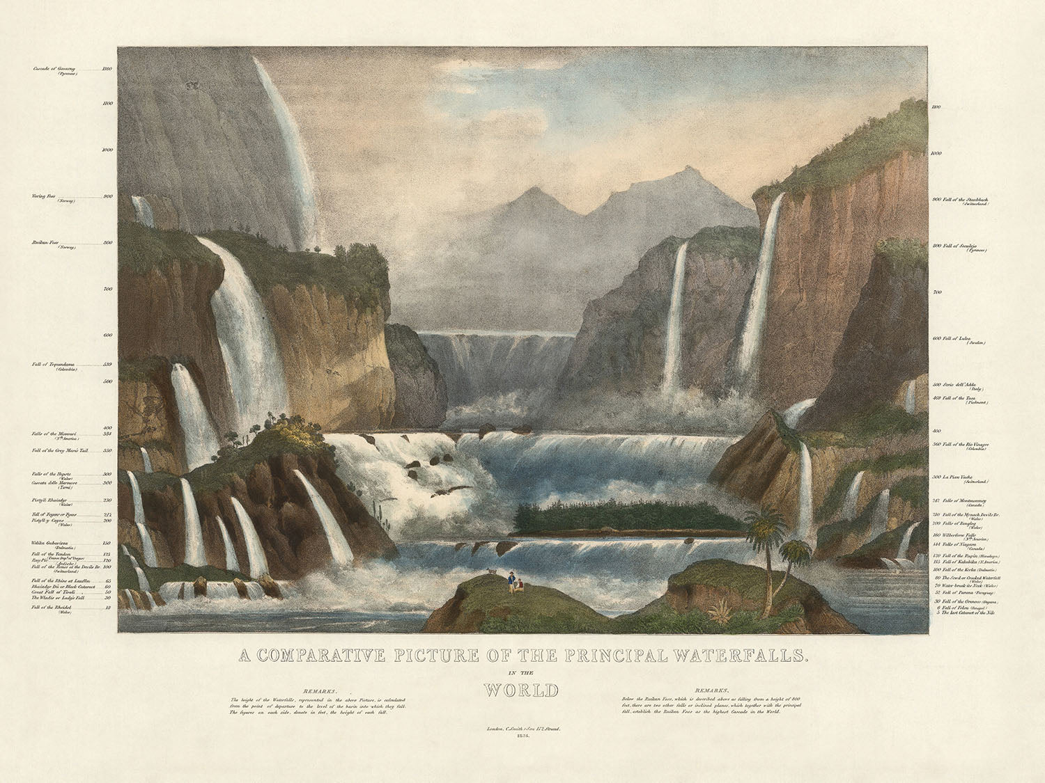
Entra nel mondo affascinante della cartografia del XIX secolo con "Un'Immagine Comparativa delle Principali Cascate del Mondo", una creazione squisita di C...
Continua a leggereEntra nel mondo affascinante della cartografia del XIX secolo con "Un'Immagine Comparativa delle Principali Cascate del Mondo", una creazione squisita di C Smith & Son del 1836. Questa mappa tematica, una delle prime viste comparative conosciute delle cascate del mondo a colori, offre una rappresentazione visiva unica di alcune delle meraviglie naturali più magnifiche del pianeta. Il focus principale della mappa è sulle altezze e sulla distribuzione geografica di queste cascate, disposte strategicamente per una facile comparazione. Dalla maestosa "Cascata di Gavarny" nei Pirenei alla "Ultima cascata del Nilo", questa mappa fornisce un'affascinante visione della grandezza di queste caratteristiche naturali.
Lo stile infografico di questa mappa è sia informativo che visivamente straordinario, con ogni cascata meticolosamente illustrata e etichettata con la propria altezza. Questo approccio artistico non solo migliora l'appeal estetico della mappa, ma funge anche da strumento educativo, permettendo agli spettatori di apprezzare la scala relativa di queste cascate. L'inclusione di note e osservazioni dettagliate aggiunge ulteriore contesto, offrendo informazioni aggiuntive sulle caratteristiche uniche e sul significato di ogni cascata.
C Smith & Son, rinomati per le loro mappe dettagliate e artistiche, hanno sapientemente combinato arte e scienza in questa creazione. La loro esperienza in cartografia è evidente nella precisione e nella chiarezza delle illustrazioni, rendendo questa mappa un pezzo prezioso sia per i collezionisti che per gli appassionati di storia naturale. Il design della mappa riflette il fascino del XIX secolo per l'esplorazione e il mondo naturale, catturando l'immaginazione degli spettatori con la sua vivida rappresentazione di queste cascate mozzafiato.
La portata geografica della mappa è impressionante, coprendo cascate dall'Europa, Africa e Americhe. Luoghi notevoli includono le maestose cascate del Missouri e del Niagara negli Stati Uniti, la pittoresca Staubbach in Svizzera e la potente Tequendama in Colombia. Ogni cascata è rappresentata in un modo che mette in evidenza la sua bellezza e grandezza uniche, offrendo una prospettiva globale su queste meraviglie naturali.
Questa mappa non è solo un piacere visivo, ma anche un artefatto storico che fornisce un'idea degli sforzi scientifici e artistici del XIX secolo. Serve come testimonianza della dedizione dell'epoca alla comprensione e alla documentazione del mondo naturale. Che tu sia un collezionista, un appassionato di storia o semplicemente qualcuno che apprezza la bellezza della natura, "Un'Immagine Comparativa delle Principali Cascate del Mondo" è un pezzo notevole che aggiungerà profondità ed eleganza a qualsiasi collezione.
Luoghi su questa mappa
- Cascata di Gavarny (Pirenei)
- Staubbach (Svizzera)
- Dunder Foss (Norvegia)
- Cascata di Trolhätten (Svezia)
- Cascata del Tequendama (Colombia)
- Cascate del Missouri (USA)
- Cascata del Fiume Montmorenci (Canada)
- Cascate del Reno (Svizzera)
- Pisse Vache (Svizzera)
- Cascata del Clyde (Scozia)
- Waleh (Africa)
- Cascata del Fiume Arve (Francia)
- Cascata del Fiume Velino (Italia)
- Cascata del Fiume Sigu (Africa)
- Cascata del Fiume Foyers (Scozia)
- Cascata del Fiume Garry (Scozia)
- Cascata del Fiume Niagara (USA/Canada)
- Cascata del Fiume Genesee (USA)
- Cascata del Fiume Trenton (USA)
- Cascata del Fiume Passaic (USA)
- Cascata del Fiume Schuylkill (USA)
- Cascata del Fiume Cohoes (USA)
- Caduta del fiume Mohawk (USA)
- Caduta del fiume Hudson (USA)
- Ultima cataratta del Nilo (Egitto)
Caratteristiche e monumenti notevoli
- Altezze di varie cascate in tutto il mondo.
- Localizzazioni geografiche di queste cascate.
- Note e osservazioni dettagliate che forniscono informazioni aggiuntive su ciascuna cascata.
- Rappresentazione artistica che aumenta l'appeal visivo e il valore educativo.
- Mettere in evidenza la diversità e la grandiosità dei paesaggi naturali.
- Riflette l'interesse del XIX secolo per le meraviglie naturali e l'esplorazione geografica.
- Fornisce uno strumento visivo per comprendere la scala relativa delle cascate.
Contesto storico e di design
- Nome della mappa: Un'immagine comparativa delle principali cascate del mondo
- Probabilmente una delle prime viste comparative delle cascate del mondo a colori.
- Cascate disposte strategicamente per il confronto dall'Europa e Africa alle Americhe.
- La cascata più alta mostrata è la "Cataratta di Gavarny (Pirenei)".
- La cascata più bassa mostrata è l'"Ultima cataratta del Nilo".
- Include osservazioni e note per un contesto aggiuntivo.
- Data di creazione: 1836
- Cartografo/Editore: C Smith & Son
- C Smith & Son erano noti per creare mappe e stampe dettagliate e artistiche durante il XIX secolo.
- Mappa tematica infografica con illustrazioni artistiche.
- Rappresentazione colorata per il confronto visivo.
- Etichettatura dettagliata di ciascuna cascata con misurazioni in altezza.
- Riflette la fascinazione del XIX secolo per l'esplorazione e il mondo naturale.
Si prega di controllare attentamente le immagini per assicurarsi che una specifica città o luogo sia mostrato su questa mappa. Puoi anche contattarci e chiedere di controllare la mappa per te.
Questa mappa appare fantastica in tutte le dimensioni, ma consiglio sempre di optare per una dimensione più grande se hai spazio. In questo modo puoi facilmente distinguere tutti i dettagli.
Questa mappa appare incredibile in dimensioni fino a 70in (180cm). Se stai cercando una mappa più grande, per favore contattaci.
Si prega di notare: le etichette su questa mappa sono difficili da leggere se ordini una mappa che è 16in (40cm) o più piccola. La mappa è comunque molto attraente, ma se desideri leggere facilmente la mappa, ti preghiamo di acquistare una dimensione più grande.
Il modello nelle immagini dell'elenco sta tenendo la versione 18x24in (45x60cm) di questa mappa.
La quinta immagine dell'elenco mostra un esempio del mio servizio di personalizzazione della mappa.
Se stai cercando qualcosa di leggermente diverso, dai un'occhiata alla mia collezione delle migliori vecchie mappe per vedere se qualcosa attira la tua attenzione.
Per favore contattami per controllare se una certa posizione, monumento o caratteristica è mostrata su questa mappa.
Questa sarebbe una meravigliosa idea regalo per un compleanno, Natale, Festa del Papà, partenza dal lavoro, anniversario o inaugurazione della casa per qualcuno delle aree coperte da questa mappa.
Questa mappa è disponibile come stampa giclée su carta opaca archiviata senza acidi, oppure puoi acquistarla incorniciata. La cornice è una semplice cornice nera che si adatta alla maggior parte degli stili. Per favore, contattaci se desideri un colore o un materiale di cornice diverso. Le mie cornici sono realizzate con acrilico di grado museale super chiaro (perspex/acrylite), che è significativamente meno riflettente del vetro, più sicuro e arriverà sempre in perfette condizioni.
This artwork is also available as a float framed canvas, sometimes known as a shadow gap framed canvas or canvas floater. The work is printed on artist's cotton canvas and then stretched over a handmade box frame. We then "float" the canvas inside a wooden frame, which is available in a range of colours (black, dark brown, oak, antique gold and white). This is a wonderful way to present an art print without glazing in front. See some examples of float framed canvas art and explore the differences between my different finishes.
Entra nel mondo affascinante della cartografia del XIX secolo con "Un'Immagine Comparativa delle Principali Cascate del Mondo", una creazione squisita di C Smith & Son del 1836. Questa mappa tematica, una delle prime viste comparative conosciute delle cascate del mondo a colori, offre una rappresentazione visiva unica di alcune delle meraviglie naturali più magnifiche del pianeta. Il focus principale della mappa è sulle altezze e sulla distribuzione geografica di queste cascate, disposte strategicamente per una facile comparazione. Dalla maestosa "Cascata di Gavarny" nei Pirenei alla "Ultima cascata del Nilo", questa mappa fornisce un'affascinante visione della grandezza di queste caratteristiche naturali.
Lo stile infografico di questa mappa è sia informativo che visivamente straordinario, con ogni cascata meticolosamente illustrata e etichettata con la propria altezza. Questo approccio artistico non solo migliora l'appeal estetico della mappa, ma funge anche da strumento educativo, permettendo agli spettatori di apprezzare la scala relativa di queste cascate. L'inclusione di note e osservazioni dettagliate aggiunge ulteriore contesto, offrendo informazioni aggiuntive sulle caratteristiche uniche e sul significato di ogni cascata.
C Smith & Son, rinomati per le loro mappe dettagliate e artistiche, hanno sapientemente combinato arte e scienza in questa creazione. La loro esperienza in cartografia è evidente nella precisione e nella chiarezza delle illustrazioni, rendendo questa mappa un pezzo prezioso sia per i collezionisti che per gli appassionati di storia naturale. Il design della mappa riflette il fascino del XIX secolo per l'esplorazione e il mondo naturale, catturando l'immaginazione degli spettatori con la sua vivida rappresentazione di queste cascate mozzafiato.
La portata geografica della mappa è impressionante, coprendo cascate dall'Europa, Africa e Americhe. Luoghi notevoli includono le maestose cascate del Missouri e del Niagara negli Stati Uniti, la pittoresca Staubbach in Svizzera e la potente Tequendama in Colombia. Ogni cascata è rappresentata in un modo che mette in evidenza la sua bellezza e grandezza uniche, offrendo una prospettiva globale su queste meraviglie naturali.
Questa mappa non è solo un piacere visivo, ma anche un artefatto storico che fornisce un'idea degli sforzi scientifici e artistici del XIX secolo. Serve come testimonianza della dedizione dell'epoca alla comprensione e alla documentazione del mondo naturale. Che tu sia un collezionista, un appassionato di storia o semplicemente qualcuno che apprezza la bellezza della natura, "Un'Immagine Comparativa delle Principali Cascate del Mondo" è un pezzo notevole che aggiungerà profondità ed eleganza a qualsiasi collezione.
Luoghi su questa mappa
- Cascata di Gavarny (Pirenei)
- Staubbach (Svizzera)
- Dunder Foss (Norvegia)
- Cascata di Trolhätten (Svezia)
- Cascata del Tequendama (Colombia)
- Cascate del Missouri (USA)
- Cascata del Fiume Montmorenci (Canada)
- Cascate del Reno (Svizzera)
- Pisse Vache (Svizzera)
- Cascata del Clyde (Scozia)
- Waleh (Africa)
- Cascata del Fiume Arve (Francia)
- Cascata del Fiume Velino (Italia)
- Cascata del Fiume Sigu (Africa)
- Cascata del Fiume Foyers (Scozia)
- Cascata del Fiume Garry (Scozia)
- Cascata del Fiume Niagara (USA/Canada)
- Cascata del Fiume Genesee (USA)
- Cascata del Fiume Trenton (USA)
- Cascata del Fiume Passaic (USA)
- Cascata del Fiume Schuylkill (USA)
- Cascata del Fiume Cohoes (USA)
- Caduta del fiume Mohawk (USA)
- Caduta del fiume Hudson (USA)
- Ultima cataratta del Nilo (Egitto)
Caratteristiche e monumenti notevoli
- Altezze di varie cascate in tutto il mondo.
- Localizzazioni geografiche di queste cascate.
- Note e osservazioni dettagliate che forniscono informazioni aggiuntive su ciascuna cascata.
- Rappresentazione artistica che aumenta l'appeal visivo e il valore educativo.
- Mettere in evidenza la diversità e la grandiosità dei paesaggi naturali.
- Riflette l'interesse del XIX secolo per le meraviglie naturali e l'esplorazione geografica.
- Fornisce uno strumento visivo per comprendere la scala relativa delle cascate.
Contesto storico e di design
- Nome della mappa: Un'immagine comparativa delle principali cascate del mondo
- Probabilmente una delle prime viste comparative delle cascate del mondo a colori.
- Cascate disposte strategicamente per il confronto dall'Europa e Africa alle Americhe.
- La cascata più alta mostrata è la "Cataratta di Gavarny (Pirenei)".
- La cascata più bassa mostrata è l'"Ultima cataratta del Nilo".
- Include osservazioni e note per un contesto aggiuntivo.
- Data di creazione: 1836
- Cartografo/Editore: C Smith & Son
- C Smith & Son erano noti per creare mappe e stampe dettagliate e artistiche durante il XIX secolo.
- Mappa tematica infografica con illustrazioni artistiche.
- Rappresentazione colorata per il confronto visivo.
- Etichettatura dettagliata di ciascuna cascata con misurazioni in altezza.
- Riflette la fascinazione del XIX secolo per l'esplorazione e il mondo naturale.
Si prega di controllare attentamente le immagini per assicurarsi che una specifica città o luogo sia mostrato su questa mappa. Puoi anche contattarci e chiedere di controllare la mappa per te.
Questa mappa appare fantastica in tutte le dimensioni, ma consiglio sempre di optare per una dimensione più grande se hai spazio. In questo modo puoi facilmente distinguere tutti i dettagli.
Questa mappa appare incredibile in dimensioni fino a 70in (180cm). Se stai cercando una mappa più grande, per favore contattaci.
Si prega di notare: le etichette su questa mappa sono difficili da leggere se ordini una mappa che è 16in (40cm) o più piccola. La mappa è comunque molto attraente, ma se desideri leggere facilmente la mappa, ti preghiamo di acquistare una dimensione più grande.
Il modello nelle immagini dell'elenco sta tenendo la versione 18x24in (45x60cm) di questa mappa.
La quinta immagine dell'elenco mostra un esempio del mio servizio di personalizzazione della mappa.
Se stai cercando qualcosa di leggermente diverso, dai un'occhiata alla mia collezione delle migliori vecchie mappe per vedere se qualcosa attira la tua attenzione.
Per favore contattami per controllare se una certa posizione, monumento o caratteristica è mostrata su questa mappa.
Questa sarebbe una meravigliosa idea regalo per un compleanno, Natale, Festa del Papà, partenza dal lavoro, anniversario o inaugurazione della casa per qualcuno delle aree coperte da questa mappa.
Questa mappa è disponibile come stampa giclée su carta opaca archiviata senza acidi, oppure puoi acquistarla incorniciata. La cornice è una semplice cornice nera che si adatta alla maggior parte degli stili. Per favore, contattaci se desideri un colore o un materiale di cornice diverso. Le mie cornici sono realizzate con acrilico di grado museale super chiaro (perspex/acrylite), che è significativamente meno riflettente del vetro, più sicuro e arriverà sempre in perfette condizioni.
This artwork is also available as a float framed canvas, sometimes known as a shadow gap framed canvas or canvas floater. The work is printed on artist's cotton canvas and then stretched over a handmade box frame. We then "float" the canvas inside a wooden frame, which is available in a range of colours (black, dark brown, oak, antique gold and white). This is a wonderful way to present an art print without glazing in front. See some examples of float framed canvas art and explore the differences between my different finishes.
Many of our maps and art prints are chosen as thoughtful gifts for homes, offices, studies and meaningful places.
Choose a framed option for the easiest ready-to-hang gift, or choose an unframed print if the recipient may prefer to select their own frame.
We make orders locally in 23 countries around the world, so gifts can often be produced close to the recipient. This helps them arrive faster, travel more safely, and avoid customs or import duty surprises.
- We can deliver directly to the recipient
- Framed pieces arrive ready to hang
- Unframed prints are carefully packed in a strong protective tube
- Almost every order is made locally, for faster, safer gifting
- 90-day returns give the recipient time to decide
If you are not sure what to choose, please contact us. We can help you pick the right map, size, finish or delivery option.
Most orders are made locally and delivered in around 2–3 working days, depending on the product, size and destination.
We print and frame maps and artwork in 23 countries around the world, so your order is usually made close to you or your recipient. That means faster delivery, less time in transit, and no customs or import duty surprises.
Personalised and customised pieces usually take an extra 1–2 working days, because we prepare your design and send it to you for approval before printing.
Very large framed orders can take a little longer, as they need extra care in production and delivery.
Every order is carefully packaged: unframed prints are sent in a strong protective tube, while framed pieces are securely packed with protective materials around the frame.
If you need your order by a particular date, please contact us before ordering. We’ll check the best production route and delivery option for your location.
Express delivery is available at checkout for most countries. Next-day delivery is available in the UK, US, Singapore and the UAE.
Your order is covered by our 90-day returns policy and 10-year guarantee.
Our standard frame is a gallery-style black ash hardwood frame, with a simple, modern look. It is approximately 20mm (0.8in) wide. You can also view some lovely customer photos of framed maps and art.
We use super-clear acrylic glazing, also known as Perspex or Acrylite, instead of traditional glass. It is lighter, safer, and has lower reflectivity, giving the artwork a clearer, cleaner appearance.
Six standard frame colours are available at no extra cost: black, dark brown, dark grey, oak, white, and antique gold. Custom framing and mounting/matting is also available for customers looking for something more specific.
Most maps, art prints, and illustrations are also available as a framed canvas. We use matte cotton canvas, stretch it over a sustainably sourced wooden box frame, and then float the piece within a wooden outer frame. The finished result is beautifully presented, with no glazing between you and the artwork.
All frames are supplied ready to hang, with either string or brackets fitted to the back. Very large frames will include heavy-duty hanging plates and/or a mounting baton. If you have any questions, please get in touch.
We can also supply old maps and artwork on canvas, foam board, cotton rag, and other materials.
If you would prefer to frame your map or artwork yourself, please read our size guide before ordering.
My maps are extremely high quality reproductions of original maps.
I source original, rare maps from libraries, auction houses and private collections around the world, restore them at my London workshop, and then use specialist giclée inks and printers to create beautiful maps that look even better than the original.
My maps are printed on acid-free archival matte (not glossy) paper that feels very high quality and almost like card. In technical terms the paper weight/thickness is 10mil/200gsm. It's perfect for framing.
I print with Epson ultrachrome giclée UV fade resistant pigment inks - some of the best inks you can find.
I can also make maps on canvas, cotton rag and other exotic materials.
Learn more about The Unique Maps Co.
Map personalisation
If you're looking for the perfect anniversary or housewarming gift, I can personalise your map to make it truly unique. For example, I can add a short message, or highlight an important location, or add your family's coat of arms.
The options are almost infinite. Please see my map personalisation page for some wonderful examples of what's possible.
To order a personalised map, select "personalise your map" before adding it to your basket.
Get in touch if you're looking for more complex customisations and personalisations.
Map ageing
I have been asked hundreds of times over the years by customers if they could buy a map that looks even older.
Well, now you can, by selecting Aged before you add a map to your basket.
All the product photos you see on this page show the map in its Original form. This is what the map looks like today.
If you select Aged, I will age your map by hand, using a special and unique process developed through years of studying old maps, talking to researchers to understand the chemistry of aging paper, and of course... lots of practice!
If you're unsure, stick to the Original colour of the map. If you want something a bit darker and older looking, go for Aged.
Se non sei soddisfatto del tuo ordine per qualsiasi motivo, contattami per un rimborso senza problemi. Si prega di consultare la nostra politica di reso e rimborso per ulteriori informazioni.
Sono molto sicuro che ti piacerà la tua mappa restaurata o la stampa d'arte. Lo faccio dal 1984. Sono un venditore Etsy a 5 stelle. Ho venduto decine di migliaia di mappe e stampe d'arte e ho oltre 5.000 recensioni reali a 5 stelle.
Utilizzo un processo unico per restaurare mappe e opere d'arte che richiede molto tempo e lavoro. Trovare le mappe e le illustrazioni originali può richiedere mesi. Utilizzo tecnologia all'avanguardia e incredibilmente costosa per scannerizzare e restaurarle. Di conseguenza, garantisco che le mie mappe e stampe d'arte siano superiori alle altre - ecco perché posso offrire un rimborso senza problemi.
Quasi tutte le mie mappe e stampe d'arte sembrano fantastiche a grandi dimensioni (200 cm, 6,5 piedi+) e posso anche incorniciarle e consegnarle a te, tramite un corriere speciale per oggetti di grandi dimensioni. Contattami per discutere delle tue esigenze specifiche.


