


Mappa antica delle Bermuda di Speed, 1627: Hamilton, St. George's, Great Sound, Tribù, Rosa dei Venti
20% di sconto su 2 — 33% di sconto su 3
Aggiungi qualsiasi due articoli idonei al tuo carrello per ricevere 20% di sconto. Aggiungi un terzo e sarà gratuito (equivalente a 33% di sconto quando acquisti tre).
Nessun codice necessario — l'offerta si applica automaticamente al checkout.
Valido su tutte le mappe standard e le stampe d'arte fine. Puoi mescolare e abbinare qualsiasi design.
Se desideri spedire articoli a più indirizzi, ti preghiamo di contattarci prima di effettuare il tuo ordine.
Le commissioni personalizzate e su misura sono escluse.
Contattaci se hai domande
 Progettato a Londra Prodotto in Australia
Progettato a Londra • Prodotto in Australia
Progettato a Londra Prodotto in Australia
Progettato a Londra • Prodotto in Australia

Restaurata dalla mappa originale del 1627 e stampata in qualità museale. Leggi la storia dietro questa mappa
Choose your size
Choose your finish


(Maggiori informazioni)
Gift message & custom finish

If you want to add a gift message, or a finish (jigsaw, aluminium board, etc.) that is not available here, please request it in the "order note" when you check out.
Every order is custom made, so if you need the size adjusted slightly, or printed on an unusual material, just let us know. We've done thousands of custom orders over the years, so there's (almost) nothing we can't manage.
You can also contact us before you order, if you prefer!

- Prodotto localmente. Consegna sicura
- Nessun dazio o costo nascosto
- Serve aiuto? Chiamaci o messaggio su WhatsApp
Own a piece of history
8,000+ five-star reviews


Mappa Aestivarum Insularum alias Bermudas dictarum, o Una Mappa delle Isole Sommer una volta chiamate Bermudas, è una creazione magistrale del rinomato...
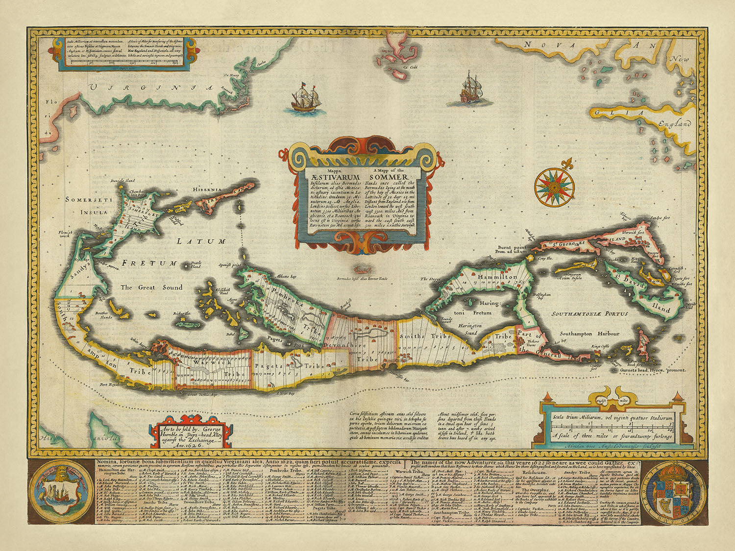
Continua a leggereMappa Aestivarum Insularum alias Bermudas dictarum, o Una Mappa delle Isole Sommer una volta chiamate Bermudas, è una creazione magistrale del rinomato cartografo John Speed, pubblicata nel 1627. Questa squisita mappa è stata compilata da Richard Norwood nel 1622 e rappresenta la prima mappa stampata in inglese a raffigurare Bermuda divisa in Tribù e Quote. Queste divisioni sono state meticolosamente designate per rappresentare le proprietà allocate agli 'Avventurieri', guidati da Sir George Sommers, dopo il loro naufragio nel 1609. Il titolo della mappa, elegantemente presentato sia in inglese che in latino, aggiunge un tocco di gravitas storica a questo gioiello cartografico.
John Speed, un celebre cartografo inglese, è meglio conosciuto per le sue mappe dettagliate e decorative. Il suo lavoro su Bermuda, inciso da Abraham Goos ad Amsterdam, non fa eccezione. L'impronta di George Humble, un'altra figura significativa nella produzione della mappa, è esposta in modo prominente. La mappa di Speed è diventata la rappresentazione standard di Bermuda nel XVII secolo, influenzando le mappe successive di noti cartografi come Blaeu, Jansson e Ogilby. Questa mappa non solo mostra la maestria cartografica di Speed, ma riflette anche gli sforzi collaborativi di alcuni dei più abili incisori ed editori dell'epoca.
La mappa illustra vividamente il paesaggio politico di Bermuda, diviso in Tribù e Quote, ciascuna meticolosamente etichettata. Queste divisioni evidenziano la terra distribuita agli 'Avventurieri', offrendo uno sguardo affascinante nella storia coloniale precoce di Bermuda. La mappa presenta anche vari punti di riferimento, come Burnt Point e Gurnet Head, che sono dettagliatamente rappresentati, offrendo una finestra sulla conoscenza geografica dell'epoca. Il Great Sound, il porto di Southampton e il Fretum di Hamilton sono tra i corpi idrici notevoli rappresentati, sottolineando l'importanza marittima dell'isola.
Elementi decorativi abbondano in questa mappa, migliorando il suo fascino visivo. Navi a vela, una vivace rosa dei venti, quattro ornate cartouches e due stemmi abbelliscono la mappa, rendendola non solo un prezioso documento storico ma anche un'opera d'arte. La meticolosa maestria di Abraham Goos è evidente in questi abbellimenti, che aggiungono un livello di eleganza e sofisticatezza alla mappa. L'inclusione di testo inglese sul verso arricchisce ulteriormente la mappa, fornendo contesto e informazioni aggiuntive per il collezionista esperto.
Questa mappa non è solo una rappresentazione di Bermuda; è una testimonianza dell'importanza storica e geografica dell'isola. La rappresentazione dettagliata di città e paesi, come Hamilton, St. George's e Somerset, insieme alle intricate divisioni di Tribù e Quote, offre un'idea unica dell'era coloniale precoce. L'importanza storica della mappa è sottolineata dal suo ruolo come mappa standard di Bermuda nel XVII secolo, uno status che ne consolida il posto negli annali della storia cartografica. Possedere questa mappa è come tenere un pezzo di storia, una connessione tangibile con il passato che continua a catturare e ispirare.
Città e paesi su questa mappa
- Hamilton (l'attuale capitale delle Bermuda)
- St. George's
- Somerset
- Harrington
- Southampton
- Smith's
- Devonshire
- Warwick
Caratteristiche e punti di riferimento notevoli
- Illustrazioni:
- Navi a vela
- Rosa dei venti
- Quattro cartouches
- Due stemmi
- Luoghi di interesse:
- Punto Bruciato
- Testa di Gurnet
- Corpi idrici:
- Il Grande Suono
- Porto di Southampton
- Fretum di Hamilton
- Confini:
- Divisioni in Tribù e Quote
- Altre caratteristiche notevoli:
- Scala delle miglia
- Impronte di Abraham Goos e George Humble
Contesto storico e di design
- Nome della mappa: Mappa Aestivarum Insularum alias Bermudas dictarum | Una mappa delle Isole Sommer una volta chiamate Bermudas . . . 1626
- Data di creazione: 1627
- Cartografo/Editore: John Speed
- Contesto aggiuntivo: La mappa è stata incisa da Abraham Goos ad Amsterdam per il "Prospect" di Speed e la sua impronta appare sotto la scala delle miglia. L'impronta di George Humble è a sinistra.
- Compilata da: Richard Norwood nel 1622
- Temi e argomenti mostrati:
- Divisioni politiche: La mappa mostra le Bermuda divise in Tribù e Quote, designando le proprietà date agli 'Avventurieri' guidati da Sir George Sommers.
- Contesto storico: Le divisioni sulla mappa corrispondono a proprietà distribuite dopo il naufragio del 1609.
- Paesi e regioni mostrati: Bermuda, con alcuni riferimenti ad aree circostanti come Virginia e Nuova Inghilterra
- Design e stile:
- Elementi decorativi: Abbellita con navi a vela, una rosa dei venti, quattro cartigli e due stemmi
- Lingua: I titoli e le etichette sono in inglese e latino
- Testo: Testo in inglese sul retro
- Significato storico:
- Prima mappa stampata in inglese: La prima mappa stampata in inglese pubblicata in un atlante per mostrare le Bermuda divise in Tribù e Quote
- Influenza: Divenne la mappa standard delle Bermuda nel XVII secolo ed è stata copiata da noti cartografi come Blaeu, Jansson e Ogilby
Si prega di controllare le immagini per assicurarsi che una specifica città o luogo sia mostrato su questa mappa. Puoi anche contattarci e chiedere di controllare la mappa per te.
Questa mappa appare fantastica a qualsiasi dimensione, ma consiglio sempre di optare per una dimensione più grande se hai spazio. In questo modo puoi facilmente distinguere tutti i dettagli.
Questa mappa sembra incredibile a dimensioni fino a 90in (230cm). Se stai cercando una mappa più grande, per favore contattaci.
Il modello nelle immagini dell'elenco tiene la versione di questa mappa 18x24in (45x60cm).
La quinta immagine dell'elenco mostra un esempio del mio servizio di personalizzazione della mappa.
Se stai cercando qualcosa di leggermente diverso, dai un'occhiata alla mia collezione delle migliori mappe antiche per vedere se qualcosa attira la tua attenzione.
Per favore contattami per controllare se un certo luogo, punto di riferimento o caratteristica è mostrato su questa mappa.
Questo sarebbe un meraviglioso regalo per un compleanno, Natale, Festa del Papà, partenza dal lavoro, anniversario o inaugurazione della casa per qualcuno delle aree coperte da questa mappa.
Questa mappa è disponibile come stampa giclée su carta opaca archiviabile senza acidi, oppure puoi acquistarla incorniciata. La cornice è una bella e semplice cornice nera che si adatta alla maggior parte degli stili. Ti preghiamo di contattarci se desideri un colore o un materiale diverso per la cornice. Le mie cornici sono rivestite con acrilico super chiaro di grado museale (perspex/acrylite), che è significativamente meno riflettente del vetro, più sicuro e arriverà sempre in perfette condizioni.
This map is also available as a float framed canvas, sometimes known as a shadow gap framed canvas or canvas floater. The map is printed on artist's cotton canvas and then stretched over a handmade box frame. We then "float" the canvas inside a wooden frame, which is available in a range of colours (black, dark brown, oak, antique gold and white). This is a wonderful way to present a map without glazing in front. See some examples of float framed canvas maps and explore the differences between my different finishes.
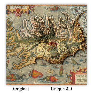
For something truly unique, this map is also available in "Unique 3D", our trademarked process that dramatically transforms the map so that it has a wonderful sense of depth. We combine the original map with detailed topography and elevation data, so that mountains and the terrain really "pop". For more info and examples of 3D maps, check my Unique 3D page.
Mappa Aestivarum Insularum alias Bermudas dictarum, o Una Mappa delle Isole Sommer una volta chiamate Bermudas, è una creazione magistrale del rinomato cartografo John Speed, pubblicata nel 1627. Questa squisita mappa è stata compilata da Richard Norwood nel 1622 e rappresenta la prima mappa stampata in inglese a raffigurare Bermuda divisa in Tribù e Quote. Queste divisioni sono state meticolosamente designate per rappresentare le proprietà allocate agli 'Avventurieri', guidati da Sir George Sommers, dopo il loro naufragio nel 1609. Il titolo della mappa, elegantemente presentato sia in inglese che in latino, aggiunge un tocco di gravitas storica a questo gioiello cartografico.
John Speed, un celebre cartografo inglese, è meglio conosciuto per le sue mappe dettagliate e decorative. Il suo lavoro su Bermuda, inciso da Abraham Goos ad Amsterdam, non fa eccezione. L'impronta di George Humble, un'altra figura significativa nella produzione della mappa, è esposta in modo prominente. La mappa di Speed è diventata la rappresentazione standard di Bermuda nel XVII secolo, influenzando le mappe successive di noti cartografi come Blaeu, Jansson e Ogilby. Questa mappa non solo mostra la maestria cartografica di Speed, ma riflette anche gli sforzi collaborativi di alcuni dei più abili incisori ed editori dell'epoca.
La mappa illustra vividamente il paesaggio politico di Bermuda, diviso in Tribù e Quote, ciascuna meticolosamente etichettata. Queste divisioni evidenziano la terra distribuita agli 'Avventurieri', offrendo uno sguardo affascinante nella storia coloniale precoce di Bermuda. La mappa presenta anche vari punti di riferimento, come Burnt Point e Gurnet Head, che sono dettagliatamente rappresentati, offrendo una finestra sulla conoscenza geografica dell'epoca. Il Great Sound, il porto di Southampton e il Fretum di Hamilton sono tra i corpi idrici notevoli rappresentati, sottolineando l'importanza marittima dell'isola.
Elementi decorativi abbondano in questa mappa, migliorando il suo fascino visivo. Navi a vela, una vivace rosa dei venti, quattro ornate cartouches e due stemmi abbelliscono la mappa, rendendola non solo un prezioso documento storico ma anche un'opera d'arte. La meticolosa maestria di Abraham Goos è evidente in questi abbellimenti, che aggiungono un livello di eleganza e sofisticatezza alla mappa. L'inclusione di testo inglese sul verso arricchisce ulteriormente la mappa, fornendo contesto e informazioni aggiuntive per il collezionista esperto.
Questa mappa non è solo una rappresentazione di Bermuda; è una testimonianza dell'importanza storica e geografica dell'isola. La rappresentazione dettagliata di città e paesi, come Hamilton, St. George's e Somerset, insieme alle intricate divisioni di Tribù e Quote, offre un'idea unica dell'era coloniale precoce. L'importanza storica della mappa è sottolineata dal suo ruolo come mappa standard di Bermuda nel XVII secolo, uno status che ne consolida il posto negli annali della storia cartografica. Possedere questa mappa è come tenere un pezzo di storia, una connessione tangibile con il passato che continua a catturare e ispirare.
Città e paesi su questa mappa
- Hamilton (l'attuale capitale delle Bermuda)
- St. George's
- Somerset
- Harrington
- Southampton
- Smith's
- Devonshire
- Warwick
Caratteristiche e punti di riferimento notevoli
- Illustrazioni:
- Navi a vela
- Rosa dei venti
- Quattro cartouches
- Due stemmi
- Luoghi di interesse:
- Punto Bruciato
- Testa di Gurnet
- Corpi idrici:
- Il Grande Suono
- Porto di Southampton
- Fretum di Hamilton
- Confini:
- Divisioni in Tribù e Quote
- Altre caratteristiche notevoli:
- Scala delle miglia
- Impronte di Abraham Goos e George Humble
Contesto storico e di design
- Nome della mappa: Mappa Aestivarum Insularum alias Bermudas dictarum | Una mappa delle Isole Sommer una volta chiamate Bermudas . . . 1626
- Data di creazione: 1627
- Cartografo/Editore: John Speed
- Contesto aggiuntivo: La mappa è stata incisa da Abraham Goos ad Amsterdam per il "Prospect" di Speed e la sua impronta appare sotto la scala delle miglia. L'impronta di George Humble è a sinistra.
- Compilata da: Richard Norwood nel 1622
- Temi e argomenti mostrati:
- Divisioni politiche: La mappa mostra le Bermuda divise in Tribù e Quote, designando le proprietà date agli 'Avventurieri' guidati da Sir George Sommers.
- Contesto storico: Le divisioni sulla mappa corrispondono a proprietà distribuite dopo il naufragio del 1609.
- Paesi e regioni mostrati: Bermuda, con alcuni riferimenti ad aree circostanti come Virginia e Nuova Inghilterra
- Design e stile:
- Elementi decorativi: Abbellita con navi a vela, una rosa dei venti, quattro cartigli e due stemmi
- Lingua: I titoli e le etichette sono in inglese e latino
- Testo: Testo in inglese sul retro
- Significato storico:
- Prima mappa stampata in inglese: La prima mappa stampata in inglese pubblicata in un atlante per mostrare le Bermuda divise in Tribù e Quote
- Influenza: Divenne la mappa standard delle Bermuda nel XVII secolo ed è stata copiata da noti cartografi come Blaeu, Jansson e Ogilby
Si prega di controllare le immagini per assicurarsi che una specifica città o luogo sia mostrato su questa mappa. Puoi anche contattarci e chiedere di controllare la mappa per te.
Questa mappa appare fantastica a qualsiasi dimensione, ma consiglio sempre di optare per una dimensione più grande se hai spazio. In questo modo puoi facilmente distinguere tutti i dettagli.
Questa mappa sembra incredibile a dimensioni fino a 90in (230cm). Se stai cercando una mappa più grande, per favore contattaci.
Il modello nelle immagini dell'elenco tiene la versione di questa mappa 18x24in (45x60cm).
La quinta immagine dell'elenco mostra un esempio del mio servizio di personalizzazione della mappa.
Se stai cercando qualcosa di leggermente diverso, dai un'occhiata alla mia collezione delle migliori mappe antiche per vedere se qualcosa attira la tua attenzione.
Per favore contattami per controllare se un certo luogo, punto di riferimento o caratteristica è mostrato su questa mappa.
Questo sarebbe un meraviglioso regalo per un compleanno, Natale, Festa del Papà, partenza dal lavoro, anniversario o inaugurazione della casa per qualcuno delle aree coperte da questa mappa.
Questa mappa è disponibile come stampa giclée su carta opaca archiviabile senza acidi, oppure puoi acquistarla incorniciata. La cornice è una bella e semplice cornice nera che si adatta alla maggior parte degli stili. Ti preghiamo di contattarci se desideri un colore o un materiale diverso per la cornice. Le mie cornici sono rivestite con acrilico super chiaro di grado museale (perspex/acrylite), che è significativamente meno riflettente del vetro, più sicuro e arriverà sempre in perfette condizioni.
This map is also available as a float framed canvas, sometimes known as a shadow gap framed canvas or canvas floater. The map is printed on artist's cotton canvas and then stretched over a handmade box frame. We then "float" the canvas inside a wooden frame, which is available in a range of colours (black, dark brown, oak, antique gold and white). This is a wonderful way to present a map without glazing in front. See some examples of float framed canvas maps and explore the differences between my different finishes.
For something truly unique, this map is also available in "Unique 3D", our trademarked process that dramatically transforms the map so that it has a wonderful sense of depth. We combine the original map with detailed topography and elevation data, so that mountains and the terrain really "pop". For more info and examples of 3D maps, check my Unique 3D page.
Many of our maps and art prints are chosen as thoughtful gifts for homes, offices, studies and meaningful places.
Choose a framed option for the easiest ready-to-hang gift, or choose an unframed print if the recipient may prefer to select their own frame.
We make orders locally in 23 countries around the world, so gifts can often be produced close to the recipient. This helps them arrive faster, travel more safely, and avoid customs or import duty surprises.
- We can deliver directly to the recipient
- Framed pieces arrive ready to hang
- Unframed prints are carefully packed in a strong protective tube
- Almost every order is made locally, for faster, safer gifting
- 90-day returns give the recipient time to decide
If you are not sure what to choose, please contact us. We can help you pick the right map, size, finish or delivery option.
Most orders are made locally and delivered in around 2–3 working days, depending on the product, size and destination.
We print and frame maps and artwork in 23 countries around the world, so your order is usually made close to you or your recipient. That means faster delivery, less time in transit, and no customs or import duty surprises.
Personalised and customised pieces usually take an extra 1–2 working days, because we prepare your design and send it to you for approval before printing.
Very large framed orders can take a little longer, as they need extra care in production and delivery.
Every order is carefully packaged: unframed prints are sent in a strong protective tube, while framed pieces are securely packed with protective materials around the frame.
If you need your order by a particular date, please contact us before ordering. We’ll check the best production route and delivery option for your location.
Express delivery is available at checkout for most countries. Next-day delivery is available in the UK, US, Singapore and the UAE.
Your order is covered by our 90-day returns policy and 10-year guarantee.
Our standard frame is a gallery-style black ash hardwood frame, with a simple, modern look. It is approximately 20mm (0.8in) wide. You can also view some lovely customer photos of framed maps and art.
We use super-clear acrylic glazing, also known as Perspex or Acrylite, instead of traditional glass. It is lighter, safer, and has lower reflectivity, giving the artwork a clearer, cleaner appearance.
Six standard frame colours are available at no extra cost: black, dark brown, dark grey, oak, white, and antique gold. Custom framing and mounting/matting is also available for customers looking for something more specific.
Most maps, art prints, and illustrations are also available as a framed canvas. We use matte cotton canvas, stretch it over a sustainably sourced wooden box frame, and then float the piece within a wooden outer frame. The finished result is beautifully presented, with no glazing between you and the artwork.
All frames are supplied ready to hang, with either string or brackets fitted to the back. Very large frames will include heavy-duty hanging plates and/or a mounting baton. If you have any questions, please get in touch.
We can also supply old maps and artwork on canvas, foam board, cotton rag, and other materials.
If you would prefer to frame your map or artwork yourself, please read our size guide before ordering.
My maps are extremely high quality reproductions of original maps.
I source original, rare maps from libraries, auction houses and private collections around the world, restore them at my London workshop, and then use specialist giclée inks and printers to create beautiful maps that look even better than the original.
My maps are printed on acid-free archival matte (not glossy) paper that feels very high quality and almost like card. In technical terms the paper weight/thickness is 10mil/200gsm. It's perfect for framing.
I print with Epson ultrachrome giclée UV fade resistant pigment inks - some of the best inks you can find.
I can also make maps on canvas, cotton rag and other exotic materials.
Learn more about The Unique Maps Co.
Map personalisation
If you're looking for the perfect anniversary or housewarming gift, I can personalise your map to make it truly unique. For example, I can add a short message, or highlight an important location, or add your family's coat of arms.
The options are almost infinite. Please see my map personalisation page for some wonderful examples of what's possible.
To order a personalised map, select "personalise your map" before adding it to your basket.
Get in touch if you're looking for more complex customisations and personalisations.
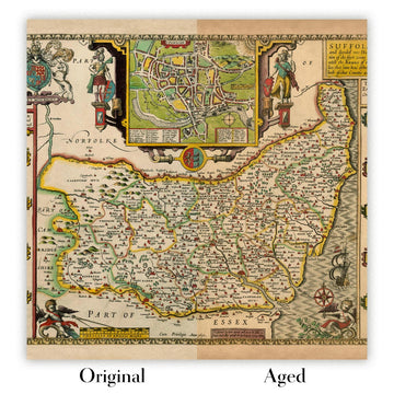
Map ageing
I have been asked hundreds of times over the years by customers if they could buy a map that looks even older.
Well, now you can, by selecting Aged before you add a map to your basket.
All the product photos you see on this page show the map in its Original form. This is what the map looks like today.
If you select Aged, I will age your map by hand, using a special and unique process developed through years of studying old maps, talking to researchers to understand the chemistry of aging paper, and of course... lots of practice!
If you're unsure, stick to the Original colour of the map. If you want something a bit darker and older looking, go for Aged.
Se non sei soddisfatto del tuo ordine per qualsiasi motivo, contattami per un rimborso senza problemi. Si prega di consultare la nostra politica di reso e rimborso per ulteriori informazioni.
Sono molto sicuro che ti piacerà la tua mappa restaurata o la stampa d'arte. Lo faccio dal 1984. Sono un venditore Etsy a 5 stelle. Ho venduto decine di migliaia di mappe e stampe d'arte e ho oltre 5.000 recensioni reali a 5 stelle.
Utilizzo un processo unico per restaurare mappe e opere d'arte che richiede molto tempo e lavoro. Trovare le mappe e le illustrazioni originali può richiedere mesi. Utilizzo tecnologia all'avanguardia e incredibilmente costosa per scannerizzare e restaurarle. Di conseguenza, garantisco che le mie mappe e stampe d'arte siano superiori alle altre - ecco perché posso offrire un rimborso senza problemi.
Quasi tutte le mie mappe e stampe d'arte sembrano fantastiche a grandi dimensioni (200 cm, 6,5 piedi+) e posso anche incorniciarle e consegnarle a te, tramite un corriere speciale per oggetti di grandi dimensioni. Contattami per discutere delle tue esigenze specifiche.
Or try searching for something!


