

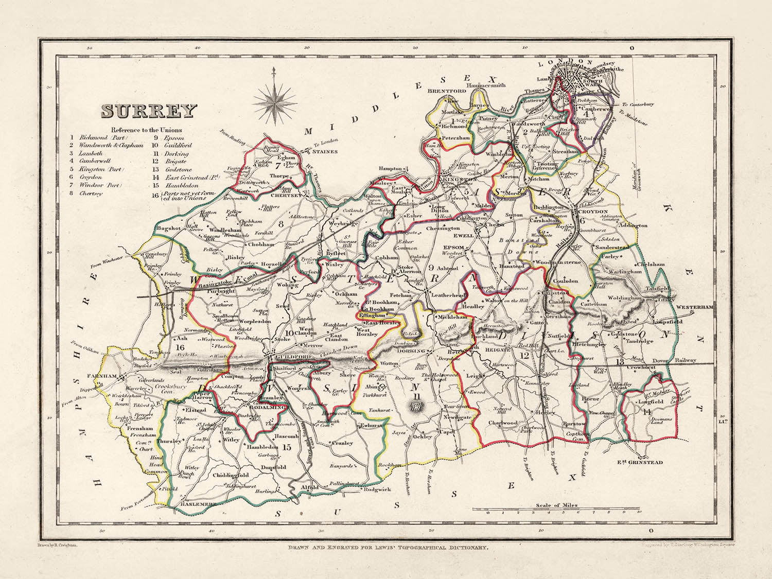


Mappa antica del Surrey di Samuel Lewis, 1844: Londra, Guildford, Woking, Ewell e Camberley
L’offerta del Collezionista
Scegli due opere idonee e ricevi il 20% di sconto su entrambe. Scegline tre e quella al prezzo più basso è in omaggio, con un risparmio massimo del 33%.
Abbina liberamente mappe standard idonee e stampe d’arte fine art. Non è richiesto alcun codice; l’offerta viene applicata automaticamente al checkout.
Sono incluse le configurazioni standard su ordinazione. Sono esclusi formati su misura, design personalizzati e lavori su commissione.
Hai bisogno di consegne a indirizzi diversi? Contattaci prima di effettuare l’ordine.L’offerta del Collezionista
Scegli due opere idonee e ricevi il 20% di sconto su entrambe. Scegline tre e quella al prezzo più basso è in omaggio, con un risparmio massimo del 33%.
Abbina liberamente mappe standard idonee e stampe d’arte fine art. Non è richiesto alcun codice; l’offerta viene applicata automaticamente al checkout.
Sono incluse le configurazioni standard su ordinazione. Sono esclusi formati su misura, design personalizzati e lavori su commissione.
Hai bisogno di consegne a indirizzi diversi? Contattaci prima di effettuare l’ordine. Restaurato a Londra • Prodotto in Australia

Restaurata dalla mappa originale del 1844 e stampata in qualità museale. Leggi la storia dietro questa mappa
Choose your size
Choose your finish


(Maggiori informazioni)
Gift message & custom finish

If you want to add a gift message, or a finish (jigsaw, aluminium board, etc.) that is not available here, please request it in the "order note" when you check out.
Every order is custom made, so if you need the size adjusted slightly, or printed on an unusual material, just let us know. We've done thousands of custom orders over the years, so there's (almost) nothing we can't manage.
You can also contact us before you order, if you prefer!

- Prodotto localmente. Consegna sicura
- Nessun dazio o costo nascosto
- Serve aiuto? Chiamaci o messaggio su WhatsApp
Own a piece of history
8,000+ five-star reviews


Abbraccia un pezzo di cartografia storica con questa straordinaria mappa del Surrey del 1844 di Samuel Lewis. Questa opera d'arte visivamente affascinante...
Continua a leggereAbbraccia un pezzo di cartografia storica con questa straordinaria mappa del Surrey del 1844 di Samuel Lewis. Questa opera d'arte visivamente affascinante è più di un semplice reperto storico; è un portale nel passato, che ci consente di tracciare l'evoluzione di alcune delle città, dei paesi e degli insediamenti più amati dell'Inghilterra, che erano già radicati nella storia al momento della creazione di questa mappa.
Immergendo nella ricca storia, il passato del Surrey può essere affascinantemente tracciato attraverso i suoi insediamenti. Questa mappa del 1844 include luoghi che prosperavano prima del 1840, alcuni dei quali si sono trasformati significativamente o hanno persino cambiato nome. Al contrario, potresti trovare un'assenza di alcuni insediamenti moderni che dovevano ancora essere fondati o riconosciuti. Questo crea un'opportunità entusiasmante per la scoperta storica e il confronto.
Insediamenti
(in ordine di dimensione della popolazione moderna):- Londra (43 d.C.): Fondata dai Romani come Londinium, era una importante città commerciale e la capitale provinciale.
- Guildford (c. 970 d.C.): Sede di una Zecca Reale dal regno del re Alfredo fino all'epoca di Guglielmo il Conquistatore.
- Woking (c. 1086 d.C.): Noto nel Domesday Book come Wochinges, era posseduto dal re Guglielmo.
- Ewell (prima del 775 d.C.): Conosciuto per i suoi resti romani, inclusi una villa e una casa da bagno.
- Camberley (c. 1200 d.C.): Storicamente parte di un'area conosciuta come Bagshot Heath, famosa per i banditi nel 17° secolo.
- Redhill (c. 1818 d.C.): Originariamente una tappa sulla strada da Londra a Brighton durante il 18° secolo.
- Reigate (c. 1088 d.C.): Sede del Castello di Reigate, ritenuto essere stato fondato poco dopo la Conquista Normanna.
- Staines-upon-Thames (c. 100 d.C.): Una storica città di mercato che un tempo era il sito di un ponte romano.
- Sunbury-on-Thames (prima del 962 d.C.): Menzionata nella Cronaca Anglo-Sassone, conosciuta per la sua posizione lungo il fiume.
- Banstead (prima del 1086 d.C.): Conosciuta per la sua storia nell'agricoltura, menzionata nel Domesday Book.
- Epsom (prima del 1086 d.C.): La casa del Sale di Epsom e dell'Epsom Derby.
- Farnham (c. 688 d.C.): Nota per il suo paesaggio urbano georgiano e un antico parco per cervi.
- Dorking (c. 1086 d.C.): Sede delle Dorking Halls, una importante sede per concerti e film.
- Chertsey (c. 666 d.C.): Conosciuta per la sua Abbazia, che era uno dei più grandi monasteri benedettini in Inghilterra.
- Godalming (c. 880 d.C.): Nel 1881, divenne la prima città al mondo ad avere un fornitura pubblica di elettricità.
- Haslemere (prima del 1221 d.C.): Conosciuta per il suo centro città "georgiano e precedente".
- Caterham (prima del 1086 d.C.): Menzionata nel Domesday Book e sede del produttore di auto Caterham Cars.
- Leatherhead (prima del 880 d.C.): Un importante incrocio sulla principale rotta da Londra alla costa meridionale.
- Esher (prima del 1086 d.C.): Sede del Claremont Landscape Garden, una nota proprietà del National Trust.
- Cobham (prima del 1086 d.C.): Conosciuta per i suoi edifici storici tra cui Cobham Mill, un mulino ad acqua del 1822.
- Walton-on-Thames (prima del 1086 d.C.): Sito di un forte romano, lo "Statio Albani," sulla strada militare per Londra.
- East Molesey (prima del 1086 d.C.): Sede del Palazzo di Hampton Court, costruito per il Cardinale Thomas Wolsey all'inizio del 16° secolo.
- Ashtead (prima del 1086 d.C.): Conosciuta per la sua villa romana e le fabbriche di tegole scavate negli anni '20 e '80.
- Horley (prima del 1086 d.C.): Situato vicino all'aeroporto di Gatwick, uno dei principali aeroporti internazionali vicino a Londra.
- Oxted (c. 1086 d.C.): Casa di una casa in legno del XVI secolo conosciuta come Titsey Place.
- Frimley (prima del 1086 d.C.): Conosciuto per l'ospedale di Frimley Park, che funge da importante struttura sanitaria regionale.
- Hersham (prima del 1086 d.C.): Casa del Burhill Golf Club, situato su una parte della vecchia tenuta del Manor.
- Addlestone (c. 1241 d.C.): Conosciuto per il Crouch Oak, un albero antico che si crede risalga all'undicesimo secolo.
- Shepperton (prima del 1086 d.C.): Conosciuto per gli Shepperton Studios, uno dei principali studi cinematografici nel Regno Unito.
- Warlingham (prima del 1086 d.C.): Conosciuto per le sue terre di cintura verde nelle Surrey Hills.
Caratteristiche Notabili:
- Il fiume Tamigi, una importante via navigabile in Inghilterra, noto per il suo ruolo nel commercio, nei trasporti e nel tempo libero.
- I North Downs, una cresta di colline di gesso, parte di un'Area di Eccezionale Bellezza Naturale (AONB).
- Box Hill, una popolare attrazione turistica con panorami mozzafiato e fauna selvatica rara.
- Il lago Virginia Water, situato nel Windsor Great Park, popolare per i suoi bellissimi paesaggi.
Eventi Storici (1800-1850):
- La costruzione della ferrovia Londra-Southampton (1838), che ha portato alla rapida crescita di città come Woking.
- La corsa inaugurale dell'Epsom Derby, una prestigiosa corsa di cavalli, nel 1780 (con la sua corsa continua ben oltre il periodo studiato).
Scopri, esplora e innamorati della storia incantevole del Surrey attraverso questa straordinaria mappa del 1844 di Samuel Lewis. Un perfetto mix di storia, arte e cultura, è davvero un'ottima aggiunta a qualsiasi collezione o un grande regalo per l'appassionato di storia.
Controlla le immagini per assicurarti che una specifica città o luogo sia mostrato su questa mappa. Puoi anche contattarci e chiedere di controllare la mappa per te.
Questa mappa appare fantastica in tutte le dimensioni: 8x10in (20.5x25.5cm), 12x16in (30.5x41cm), 18x24in (45.5x61cm), 16x20in (40.5x51cm), 24x36in (61x91.5cm), 30x40in (76x101.5cm) e 37x50in (94x127cm), ma appare ancora meglio se stampata in grande.
Posso creare stampe belle e grandi di questa mappa fino a 50in (127cm). Contattami se stai cercando opzioni di incorniciatura più grandi, personalizzate o diverse.
Il modello nelle immagini dell'annuncio tiene la versione 18x24in (45.5x61cm) di questa mappa.
La quinta immagine dell'annuncio mostra un esempio del mio servizio di personalizzazione della mappa.
Se stai cercando qualcosa di leggermente diverso, dai un'occhiata alla mia principale collezione di mappe del Regno Unito e dell'Irlanda.
Per favore contattami per controllare se una certa posizione, un punto di riferimento o una caratteristica è mostrata su questa mappa.
Questo sarebbe un meraviglioso regalo di compleanno, Natale, Festa del Papà, partenza dal lavoro, anniversario o per una festa di inaugurazione per qualcuno delle aree coperte da questa mappa.
Questa mappa è disponibile come stampa giclée su carta opaca archivistica senza acidi, oppure puoi acquistarla incorniciata. La cornice è una semplice cornice nera che si adatta alla maggior parte degli stili. Contattami se desideri un colore o materiale della cornice diverso. Le mie cornici sono dotate di un acrilico (perspex/acrylite) di grado museale super chiaro, che è significativamente meno riflettente del vetro, più sicuro e arriverà sempre in perfette condizioni.
This map is also available as a float framed canvas, sometimes known as a shadow gap framed canvas or canvas floater. The map is printed on artist's cotton canvas and then stretched over a handmade box frame. We then "float" the canvas inside a wooden frame, which is available in a range of colours (black, dark brown, oak, antique gold and white). This is a wonderful way to present a map without glazing in front. See some examples of float framed canvas maps and explore the differences between my different finishes.
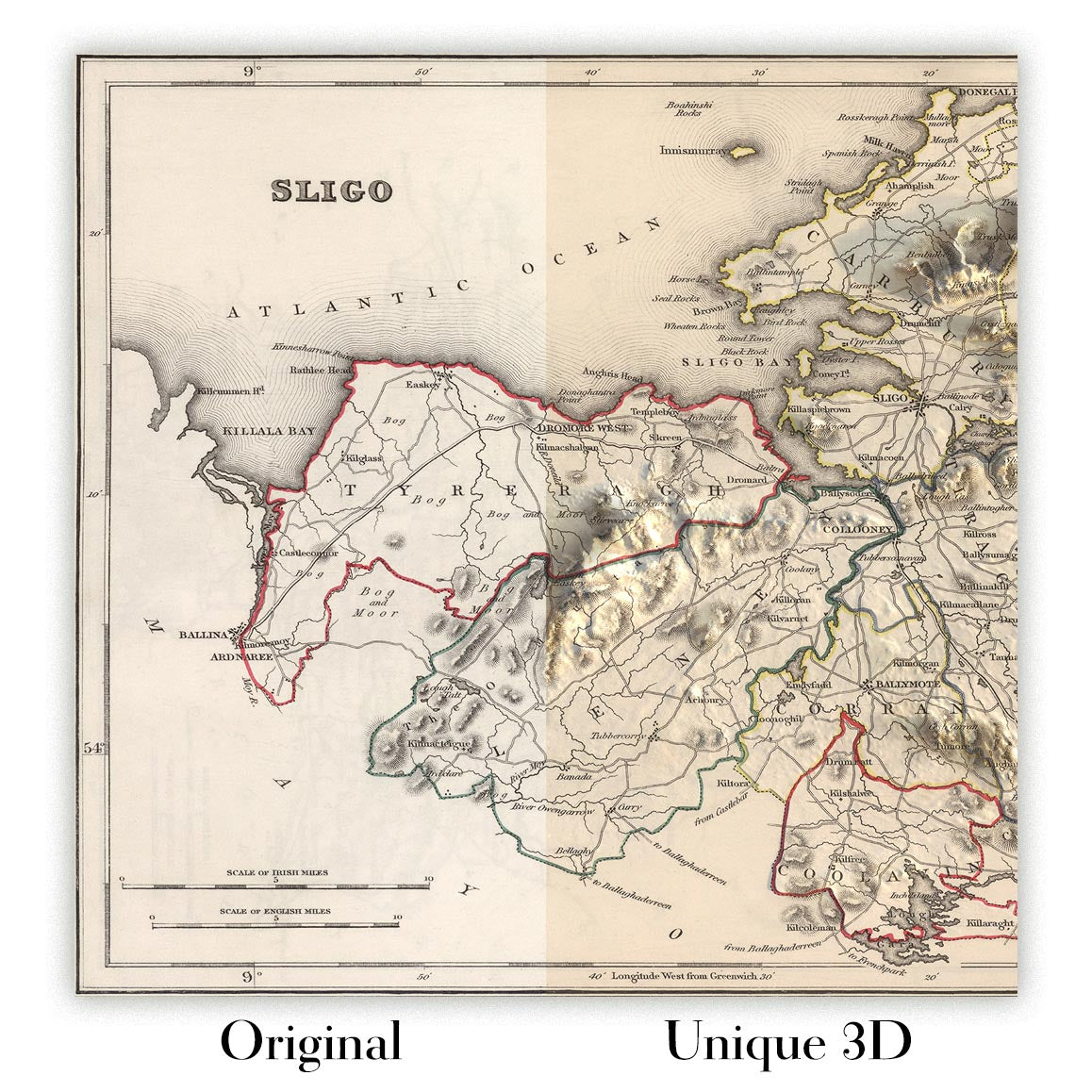
For something truly unique, this map is also available in "Unique 3D", our trademarked process that dramatically transforms the map so that it has a wonderful sense of depth. We combine the original map with detailed topography and elevation data, so that mountains and the terrain really "pop". For more info and examples of 3D maps, check my Unique 3D page.
Abbraccia un pezzo di cartografia storica con questa straordinaria mappa del Surrey del 1844 di Samuel Lewis. Questa opera d'arte visivamente affascinante è più di un semplice reperto storico; è un portale nel passato, che ci consente di tracciare l'evoluzione di alcune delle città, dei paesi e degli insediamenti più amati dell'Inghilterra, che erano già radicati nella storia al momento della creazione di questa mappa.
Immergendo nella ricca storia, il passato del Surrey può essere affascinantemente tracciato attraverso i suoi insediamenti. Questa mappa del 1844 include luoghi che prosperavano prima del 1840, alcuni dei quali si sono trasformati significativamente o hanno persino cambiato nome. Al contrario, potresti trovare un'assenza di alcuni insediamenti moderni che dovevano ancora essere fondati o riconosciuti. Questo crea un'opportunità entusiasmante per la scoperta storica e il confronto.
Insediamenti
(in ordine di dimensione della popolazione moderna):- Londra (43 d.C.): Fondata dai Romani come Londinium, era una importante città commerciale e la capitale provinciale.
- Guildford (c. 970 d.C.): Sede di una Zecca Reale dal regno del re Alfredo fino all'epoca di Guglielmo il Conquistatore.
- Woking (c. 1086 d.C.): Noto nel Domesday Book come Wochinges, era posseduto dal re Guglielmo.
- Ewell (prima del 775 d.C.): Conosciuto per i suoi resti romani, inclusi una villa e una casa da bagno.
- Camberley (c. 1200 d.C.): Storicamente parte di un'area conosciuta come Bagshot Heath, famosa per i banditi nel 17° secolo.
- Redhill (c. 1818 d.C.): Originariamente una tappa sulla strada da Londra a Brighton durante il 18° secolo.
- Reigate (c. 1088 d.C.): Sede del Castello di Reigate, ritenuto essere stato fondato poco dopo la Conquista Normanna.
- Staines-upon-Thames (c. 100 d.C.): Una storica città di mercato che un tempo era il sito di un ponte romano.
- Sunbury-on-Thames (prima del 962 d.C.): Menzionata nella Cronaca Anglo-Sassone, conosciuta per la sua posizione lungo il fiume.
- Banstead (prima del 1086 d.C.): Conosciuta per la sua storia nell'agricoltura, menzionata nel Domesday Book.
- Epsom (prima del 1086 d.C.): La casa del Sale di Epsom e dell'Epsom Derby.
- Farnham (c. 688 d.C.): Nota per il suo paesaggio urbano georgiano e un antico parco per cervi.
- Dorking (c. 1086 d.C.): Sede delle Dorking Halls, una importante sede per concerti e film.
- Chertsey (c. 666 d.C.): Conosciuta per la sua Abbazia, che era uno dei più grandi monasteri benedettini in Inghilterra.
- Godalming (c. 880 d.C.): Nel 1881, divenne la prima città al mondo ad avere un fornitura pubblica di elettricità.
- Haslemere (prima del 1221 d.C.): Conosciuta per il suo centro città "georgiano e precedente".
- Caterham (prima del 1086 d.C.): Menzionata nel Domesday Book e sede del produttore di auto Caterham Cars.
- Leatherhead (prima del 880 d.C.): Un importante incrocio sulla principale rotta da Londra alla costa meridionale.
- Esher (prima del 1086 d.C.): Sede del Claremont Landscape Garden, una nota proprietà del National Trust.
- Cobham (prima del 1086 d.C.): Conosciuta per i suoi edifici storici tra cui Cobham Mill, un mulino ad acqua del 1822.
- Walton-on-Thames (prima del 1086 d.C.): Sito di un forte romano, lo "Statio Albani," sulla strada militare per Londra.
- East Molesey (prima del 1086 d.C.): Sede del Palazzo di Hampton Court, costruito per il Cardinale Thomas Wolsey all'inizio del 16° secolo.
- Ashtead (prima del 1086 d.C.): Conosciuta per la sua villa romana e le fabbriche di tegole scavate negli anni '20 e '80.
- Horley (prima del 1086 d.C.): Situato vicino all'aeroporto di Gatwick, uno dei principali aeroporti internazionali vicino a Londra.
- Oxted (c. 1086 d.C.): Casa di una casa in legno del XVI secolo conosciuta come Titsey Place.
- Frimley (prima del 1086 d.C.): Conosciuto per l'ospedale di Frimley Park, che funge da importante struttura sanitaria regionale.
- Hersham (prima del 1086 d.C.): Casa del Burhill Golf Club, situato su una parte della vecchia tenuta del Manor.
- Addlestone (c. 1241 d.C.): Conosciuto per il Crouch Oak, un albero antico che si crede risalga all'undicesimo secolo.
- Shepperton (prima del 1086 d.C.): Conosciuto per gli Shepperton Studios, uno dei principali studi cinematografici nel Regno Unito.
- Warlingham (prima del 1086 d.C.): Conosciuto per le sue terre di cintura verde nelle Surrey Hills.
Caratteristiche Notabili:
- Il fiume Tamigi, una importante via navigabile in Inghilterra, noto per il suo ruolo nel commercio, nei trasporti e nel tempo libero.
- I North Downs, una cresta di colline di gesso, parte di un'Area di Eccezionale Bellezza Naturale (AONB).
- Box Hill, una popolare attrazione turistica con panorami mozzafiato e fauna selvatica rara.
- Il lago Virginia Water, situato nel Windsor Great Park, popolare per i suoi bellissimi paesaggi.
Eventi Storici (1800-1850):
- La costruzione della ferrovia Londra-Southampton (1838), che ha portato alla rapida crescita di città come Woking.
- La corsa inaugurale dell'Epsom Derby, una prestigiosa corsa di cavalli, nel 1780 (con la sua corsa continua ben oltre il periodo studiato).
Scopri, esplora e innamorati della storia incantevole del Surrey attraverso questa straordinaria mappa del 1844 di Samuel Lewis. Un perfetto mix di storia, arte e cultura, è davvero un'ottima aggiunta a qualsiasi collezione o un grande regalo per l'appassionato di storia.
Controlla le immagini per assicurarti che una specifica città o luogo sia mostrato su questa mappa. Puoi anche contattarci e chiedere di controllare la mappa per te.
Questa mappa appare fantastica in tutte le dimensioni: 8x10in (20.5x25.5cm), 12x16in (30.5x41cm), 18x24in (45.5x61cm), 16x20in (40.5x51cm), 24x36in (61x91.5cm), 30x40in (76x101.5cm) e 37x50in (94x127cm), ma appare ancora meglio se stampata in grande.
Posso creare stampe belle e grandi di questa mappa fino a 50in (127cm). Contattami se stai cercando opzioni di incorniciatura più grandi, personalizzate o diverse.
Il modello nelle immagini dell'annuncio tiene la versione 18x24in (45.5x61cm) di questa mappa.
La quinta immagine dell'annuncio mostra un esempio del mio servizio di personalizzazione della mappa.
Se stai cercando qualcosa di leggermente diverso, dai un'occhiata alla mia principale collezione di mappe del Regno Unito e dell'Irlanda.
Per favore contattami per controllare se una certa posizione, un punto di riferimento o una caratteristica è mostrata su questa mappa.
Questo sarebbe un meraviglioso regalo di compleanno, Natale, Festa del Papà, partenza dal lavoro, anniversario o per una festa di inaugurazione per qualcuno delle aree coperte da questa mappa.
Questa mappa è disponibile come stampa giclée su carta opaca archivistica senza acidi, oppure puoi acquistarla incorniciata. La cornice è una semplice cornice nera che si adatta alla maggior parte degli stili. Contattami se desideri un colore o materiale della cornice diverso. Le mie cornici sono dotate di un acrilico (perspex/acrylite) di grado museale super chiaro, che è significativamente meno riflettente del vetro, più sicuro e arriverà sempre in perfette condizioni.
This map is also available as a float framed canvas, sometimes known as a shadow gap framed canvas or canvas floater. The map is printed on artist's cotton canvas and then stretched over a handmade box frame. We then "float" the canvas inside a wooden frame, which is available in a range of colours (black, dark brown, oak, antique gold and white). This is a wonderful way to present a map without glazing in front. See some examples of float framed canvas maps and explore the differences between my different finishes.
For something truly unique, this map is also available in "Unique 3D", our trademarked process that dramatically transforms the map so that it has a wonderful sense of depth. We combine the original map with detailed topography and elevation data, so that mountains and the terrain really "pop". For more info and examples of 3D maps, check my Unique 3D page.
Many of our maps and art prints are chosen as thoughtful gifts for homes, offices, studies and meaningful places.
Choose a framed option for the easiest ready-to-hang gift, or choose an unframed print if the recipient may prefer to select their own frame.
We make orders locally in 23 countries around the world, so gifts can often be produced close to the recipient. This helps them arrive faster, travel more safely, and avoid customs or import duty surprises.
- We can deliver directly to the recipient
- Framed pieces arrive ready to hang
- Unframed prints are carefully packed in a strong protective tube
- Almost every order is made locally, for faster, safer gifting
- 90-day returns give the recipient time to decide
If you are not sure what to choose, please contact us. We can help you pick the right map, size, finish or delivery option.
Most orders are made locally and delivered in around 2–3 working days, depending on the product, size and destination.
We print and frame maps and artwork in 23 countries around the world, so your order is usually made close to you or your recipient. That means faster delivery, less time in transit, and no customs or import duty surprises.
Personalised and customised pieces usually take an extra 1–2 working days, because we prepare your design and send it to you for approval before printing.
Very large framed orders can take a little longer, as they need extra care in production and delivery.
Every order is carefully packaged: unframed prints are sent in a strong protective tube, while framed pieces are securely packed with protective materials around the frame.
If you need your order by a particular date, please contact us before ordering. We’ll check the best production route and delivery option for your location.
Express delivery is available at checkout for most countries. Next-day delivery is available in the UK, US, Singapore and the UAE.
Your order is covered by our 90-day returns policy and 10-year guarantee.
Our standard frame is a gallery-style black ash hardwood frame, with a simple, modern look. It is approximately 20mm (0.8in) wide. You can also view some lovely customer photos of framed maps and art.
We use super-clear acrylic glazing, also known as Perspex or Acrylite, instead of traditional glass. It is lighter, safer, and has lower reflectivity, giving the artwork a clearer, cleaner appearance.
Six standard frame colours are available at no extra cost: black, dark brown, dark grey, oak, white, and antique gold. Custom framing and mounting/matting is also available for customers looking for something more specific.
Most maps, art prints, and illustrations are also available as a framed canvas. We use matte cotton canvas, stretch it over a sustainably sourced wooden box frame, and then float the piece within a wooden outer frame. The finished result is beautifully presented, with no glazing between you and the artwork.
All frames are supplied ready to hang, with either string or brackets fitted to the back. Very large frames will include heavy-duty hanging plates and/or a mounting baton. If you have any questions, please get in touch.
We can also supply old maps and artwork on canvas, foam board, cotton rag, and other materials.
If you would prefer to frame your map or artwork yourself, please read our size guide before ordering.
Every Unique Maps piece begins with an authentic cartographic source or an original design from our London studio.
For our historic maps, we source rare originals from libraries, archives, auction houses and private collections around the world. We carefully restore each map for print—repairing age-related damage, balancing colour and improving clarity while preserving its original detail, texture and character.
Once restored, the map is prepared for your chosen size and finish. Your piece is then printed and, where selected, framed close to its delivery destination.
Our map prints use acid-free 200gsm archival matte paper and fade-resistant pigment inks, creating a rich, non-glossy finish designed to last. Framed maps use crystal-clear optical acrylic and arrive ready to hang.
Canvas, cotton-rag and other specialist presentations are also available. Learn more about our materials and finishes.
Personalising your map
You can add a short title or dedication, mark one meaningful place, or request one considered visual detail. For personalised designs, we send a proof before printing and you can request changes before approval.
For more complex bespoke commissions, contact our design team.
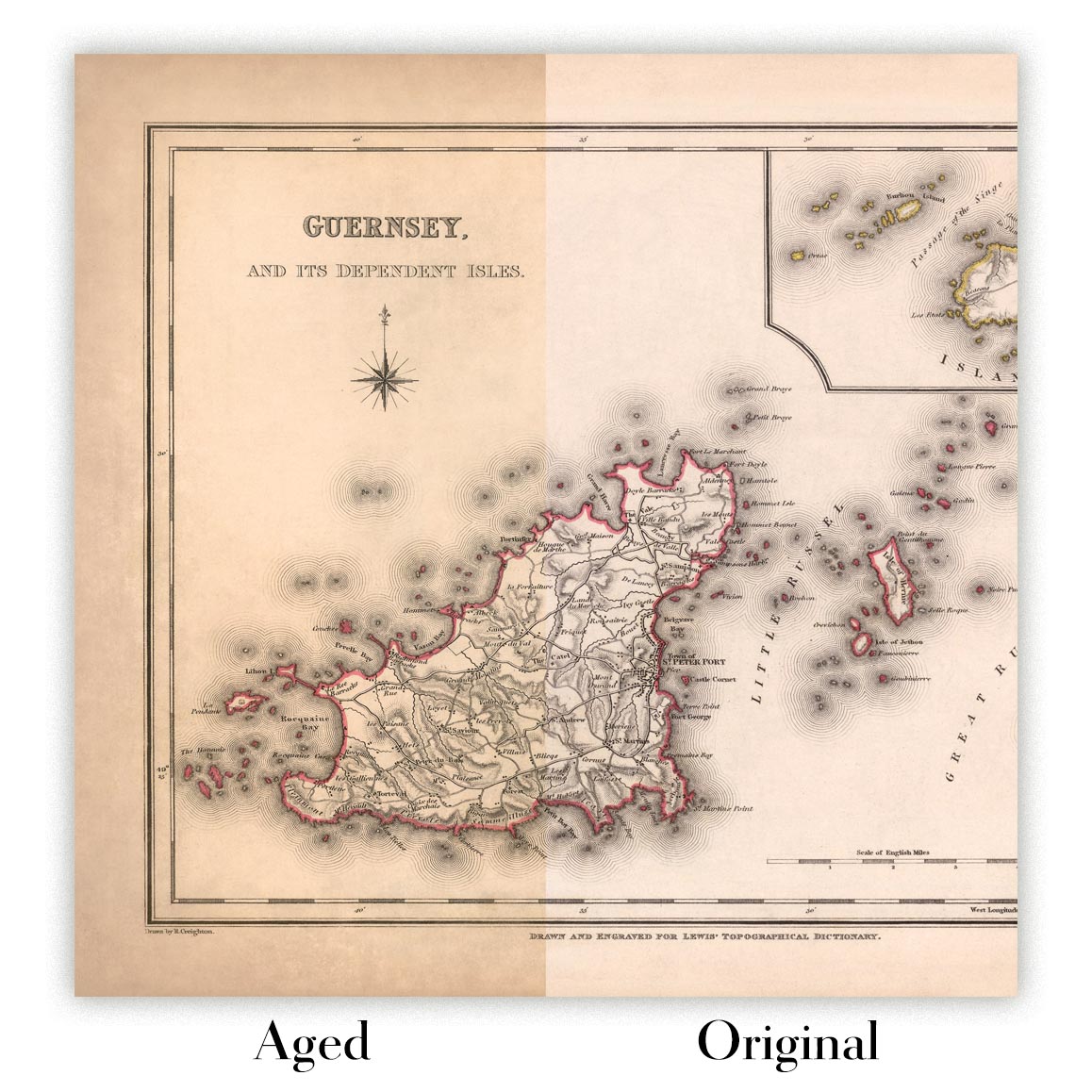
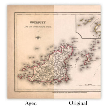
Original or Aged
Choose Original for true-to-source colour, or Aged for a warmer, richer antique character created with our specialist ageing process. See examples of our Aged maps.
Se non sei soddisfatto del tuo ordine per qualsiasi motivo, contattami per un rimborso senza problemi. Si prega di consultare la nostra politica di reso e rimborso per ulteriori informazioni.
Sono molto sicuro che ti piacerà la tua mappa restaurata o la stampa d'arte. Lo faccio dal 1984. Sono un venditore Etsy a 5 stelle. Ho venduto decine di migliaia di mappe e stampe d'arte e ho oltre 5.000 recensioni reali a 5 stelle.
Utilizzo un processo unico per restaurare mappe e opere d'arte che richiede molto tempo e lavoro. Trovare le mappe e le illustrazioni originali può richiedere mesi. Utilizzo tecnologia all'avanguardia e incredibilmente costosa per scannerizzare e restaurarle. Di conseguenza, garantisco che le mie mappe e stampe d'arte siano superiori alle altre - ecco perché posso offrire un rimborso senza problemi.
Quasi tutte le mie mappe e stampe d'arte sembrano fantastiche a grandi dimensioni (200 cm, 6,5 piedi+) e posso anche incorniciarle e consegnarle a te, tramite un corriere speciale per oggetti di grandi dimensioni. Contattami per discutere delle tue esigenze specifiche.
Or try searching for something!


