


Rare Old Map of Tasmania by Arrowsmith, 1844: Van Diemen's Land, Hobart, Launceston, Devonport, Burnie, VDL Co. grants
L’offerta del Collezionista
Scegli due opere idonee e ricevi il 20% di sconto su entrambe. Scegline tre e quella al prezzo più basso è in omaggio, con un risparmio massimo del 33%.
Abbina liberamente mappe standard idonee e stampe d’arte fine art. Non è richiesto alcun codice; l’offerta viene applicata automaticamente al checkout.
Sono incluse le configurazioni standard su ordinazione. Sono esclusi formati su misura, design personalizzati e lavori su commissione.
Hai bisogno di consegne a indirizzi diversi? Contattaci prima di effettuare l’ordine.L’offerta del Collezionista
Scegli due opere idonee e ricevi il 20% di sconto su entrambe. Scegline tre e quella al prezzo più basso è in omaggio, con un risparmio massimo del 33%.
Abbina liberamente mappe standard idonee e stampe d’arte fine art. Non è richiesto alcun codice; l’offerta viene applicata automaticamente al checkout.
Sono incluse le configurazioni standard su ordinazione. Sono esclusi formati su misura, design personalizzati e lavori su commissione.
Hai bisogno di consegne a indirizzi diversi? Contattaci prima di effettuare l’ordine. Progettato a Londra Prodotto in Australia
Progettato a Londra • Prodotto in Australia
Progettato a Londra Prodotto in Australia
Progettato a Londra • Prodotto in Australia

Restaurata dalla mappa originale del 1844 e stampata in qualità museale. Leggi la storia dietro questa mappa
Choose your size
Choose your finish


(Maggiori informazioni)
Gift message & custom finish

If you want to add a gift message, or a finish (jigsaw, aluminium board, etc.) that is not available here, please request it in the "order note" when you check out.
Every order is custom made, so if you need the size adjusted slightly, or printed on an unusual material, just let us know. We've done thousands of custom orders over the years, so there's (almost) nothing we can't manage.
You can also contact us before you order, if you prefer!

- Prodotto localmente. Consegna sicura
- Nessun dazio o costo nascosto
- Serve aiuto? Chiamaci o messaggio su WhatsApp
Own a piece of history
8,000+ five-star reviews


Van Diemen's Land (1844) by John Arrowsmith captures Tasmania at a decisive colonial moment, its title announcing both the island’s earlier name...
Continua a leggereVan Diemen's Land (1844) by John Arrowsmith captures Tasmania at a decisive colonial moment, its title announcing both the island’s earlier name and the administrative clarity that defines the sheet. Across the island, colored outlines crisply distinguish counties and districts, while neat lettering and disciplined engraving present a balanced synthesis of political and physical knowledge. Arrowsmith threads settlements, roads, and surveyed boundaries across mountains, rivers, and coastal inlets, revealing how terrain shaped authority and ambition. Most striking is the careful plotting of land grants associated with the Van Diemen’s Land Company, a cartographic window onto policies that organized occupation and enterprise. Long overlooked and absent from many major cartographic references, this scarce edition distills imperial intent, geographic reality, and emerging local identity into a single, lucid view.
John Arrowsmith, a leading light of nineteenth-century British cartography, worked at a moment when surveying precision and presentation were advancing in tandem. He favored legible, information-rich layouts that privileged function without sacrificing grace, and this map is exemplary. The palette of washes is restrained yet purposeful, establishing jurisdictional hierarchies at a glance, while fine hachures articulate relief and guide the eye from the central highlands to the sea. Hydrography is traced with a sure hand, anchoring the island’s circulation and settlement patterns. Arrowsmith’s imprint signaled authority to administrators, explorers, and merchants alike, and here he converts a web of colonial reports and surveys into a coherent narrative. The understated cartouche underscores that ethos: elegance serving exactitude, ornament never obscuring fact.
Physical geography animates the sheet with a topographer’s sensibility. Mountain chains mass in the interior, their flanks feathered into foothills, while river systems radiate toward the southern estuaries and the northern straits. Forested tracts, lakes, and marshier lowlands register as textures within this relief, reminding the viewer that resource, route, and risk were inseparable in Tasmanian space. The Derwent’s broad estuary frames Hobart’s position, and the Tamar lends form to Launceston’s northern reach, just as lesser rivers stitch the coast to the interior. Bays, headlands, and sounds are plotted with nautical clarity, expressing the island’s dual dependence on harbors and inland corridors. In Arrowsmith’s hands, nature is not backdrop but protagonist—the determinant of where lines of property, polity, and passage can plausibly run.
Settlements emerge with strategic logic along coasts and river mouths. Hobart anchors the south, its siting between sheltering hills and a navigable estuary emblematic of colonial pragmatism. Launceston balances the north, commanding an inland waterway and fertile hinterland, while younger coastal towns—Devonport to the northwest and Burnie farther west—signal expanding maritime reach. Arrowsmith marks these towns and their connecting routes with just enough emphasis to reveal a lattice of movement: from port to pasture, courthouse to company station. County outlines frame these nodes, but the engraver’s discipline ensures that borders never overwhelm the delicate tracery of streams, ridges, and shorelines. The result is a living geography of administration and growth, in which survey lines meet the contingencies of weather, gradient, and tide.
At the heart of the composition lies the delineation of land grants to the Van Diemen’s Land Company, a rare, explicit mapping of corporate tenure and ambition. Their boundaries are drawn with surveyed rectitude, yet their placement—often against forest margins, river courses, or coastal access—betrays economic calculus: pasture, timber, and transport. This documentary clarity makes the map an essential witness to colonial land policy, capturing how authority parceled an island into units of governance and profit. The tasteful cartouche, scale, and notation quietly authenticate the whole, aligning with Arrowsmith’s credo of clarity. Scarce in the literature and seldom cited in major references, the map endures as both primary record and aesthetic achievement—an artifact in which design and documentary purpose are perfectly allied.
Cities and towns on this map
- Hobart: Capital city; modern population approximately 230,000.
- Launceston: Major city; modern population around 87,000.
- Devonport: Regional city; modern population about 25,000.
- Burnie: Port city; modern population around 19,000.
Notable Features & Landmarks
- Detailed representation of land grants to the Van Diemen's Land Company.
- Color outlines delineating different regions or counties.
- Major geographic features such as mountains, rivers, and forests.
- Locations of settlements and towns.
- Boundaries of various land grants.
- The cartouche and other design elements that signify the map's authenticity.
Historical and design context
- Date Created: 1844.
- Mapmaker/Publisher: John Arrowsmith.
- Mapmaker Context: John Arrowsmith was a significant cartographer known for producing detailed maps during the 19th century, a period marked by advancements in cartographic techniques and presentation.
- Topics and Themes: The map showcases political and physical features of Van Diemen's Land (now Tasmania) including land grants and settlements, a reflection of the colonial land policies of the time.
- Design/Style: The map is noted for its colored outlines which distinguish various regions, reflecting the cartographic style of the era, characterized by clarity and detail.
- Historical Significance: This map is an important historical document reflecting the administrative and colonial land arrangements pertinent to the Van Diemen's Land Company. Its rarity is noted as it is not included in major cartographic references.
Please double check the images to make sure that a specific town or place is shown on this map. You can also get in touch and ask us to check the map for you.
This map looks great at every size, but I always recommend going for a larger size if you have space. That way you can easily make out all of the details.
This map looks amazing at sizes all the way up to 70in (180cm). If you are looking for a larger map, please get in touch.
Please note: the labels on this map are hard to read if you order a map that is 16in (40cm) or smaller. The map is still very attractive, but if you would like to read the map easily, please buy a larger size.
The model in the listing images is holding the 16x20in (40x50cm) version of this map.
The fifth listing image shows an example of my map personalisation service.
If you’re looking for something slightly different, check out my collection of the best old maps to see if something else catches your eye.
Please contact me to check if a certain location, landmark or feature is shown on this map.
This would make a wonderful birthday, Christmas, Father's Day, work leaving, anniversary or housewarming gift for someone from the areas covered by this map.
This map is available as a giclée print on acid free archival matte paper, or you can buy it framed. The frame is a nice, simple black frame that suits most aesthetics. Please get in touch if you'd like a different frame colour or material. My frames are glazed with super-clear museum-grade acrylic (perspex/acrylite), which is significantly less reflective than glass, safer, and will always arrive in perfect condition.
This map is also available as a float framed canvas, sometimes known as a shadow gap framed canvas or canvas floater. The map is printed on artist's cotton canvas and then stretched over a handmade box frame. We then "float" the canvas inside a wooden frame, which is available in a range of colours (black, dark brown, oak, antique gold and white). This is a wonderful way to present a map without glazing in front. See some examples of float framed canvas maps and explore the differences between my different finishes.
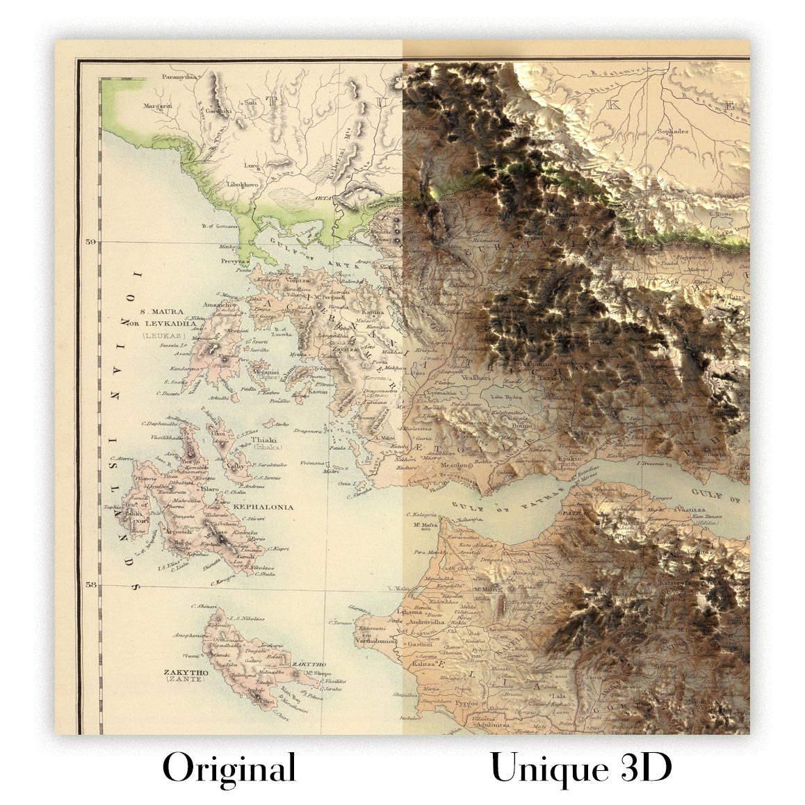
For something truly unique, this map is also available in "Unique 3D", our trademarked process that dramatically transforms the map so that it has a wonderful sense of depth. We combine the original map with detailed topography and elevation data, so that mountains and the terrain really "pop". For more info and examples of 3D maps, check my Unique 3D page.
Van Diemen's Land (1844) by John Arrowsmith captures Tasmania at a decisive colonial moment, its title announcing both the island’s earlier name and the administrative clarity that defines the sheet. Across the island, colored outlines crisply distinguish counties and districts, while neat lettering and disciplined engraving present a balanced synthesis of political and physical knowledge. Arrowsmith threads settlements, roads, and surveyed boundaries across mountains, rivers, and coastal inlets, revealing how terrain shaped authority and ambition. Most striking is the careful plotting of land grants associated with the Van Diemen’s Land Company, a cartographic window onto policies that organized occupation and enterprise. Long overlooked and absent from many major cartographic references, this scarce edition distills imperial intent, geographic reality, and emerging local identity into a single, lucid view.
John Arrowsmith, a leading light of nineteenth-century British cartography, worked at a moment when surveying precision and presentation were advancing in tandem. He favored legible, information-rich layouts that privileged function without sacrificing grace, and this map is exemplary. The palette of washes is restrained yet purposeful, establishing jurisdictional hierarchies at a glance, while fine hachures articulate relief and guide the eye from the central highlands to the sea. Hydrography is traced with a sure hand, anchoring the island’s circulation and settlement patterns. Arrowsmith’s imprint signaled authority to administrators, explorers, and merchants alike, and here he converts a web of colonial reports and surveys into a coherent narrative. The understated cartouche underscores that ethos: elegance serving exactitude, ornament never obscuring fact.
Physical geography animates the sheet with a topographer’s sensibility. Mountain chains mass in the interior, their flanks feathered into foothills, while river systems radiate toward the southern estuaries and the northern straits. Forested tracts, lakes, and marshier lowlands register as textures within this relief, reminding the viewer that resource, route, and risk were inseparable in Tasmanian space. The Derwent’s broad estuary frames Hobart’s position, and the Tamar lends form to Launceston’s northern reach, just as lesser rivers stitch the coast to the interior. Bays, headlands, and sounds are plotted with nautical clarity, expressing the island’s dual dependence on harbors and inland corridors. In Arrowsmith’s hands, nature is not backdrop but protagonist—the determinant of where lines of property, polity, and passage can plausibly run.
Settlements emerge with strategic logic along coasts and river mouths. Hobart anchors the south, its siting between sheltering hills and a navigable estuary emblematic of colonial pragmatism. Launceston balances the north, commanding an inland waterway and fertile hinterland, while younger coastal towns—Devonport to the northwest and Burnie farther west—signal expanding maritime reach. Arrowsmith marks these towns and their connecting routes with just enough emphasis to reveal a lattice of movement: from port to pasture, courthouse to company station. County outlines frame these nodes, but the engraver’s discipline ensures that borders never overwhelm the delicate tracery of streams, ridges, and shorelines. The result is a living geography of administration and growth, in which survey lines meet the contingencies of weather, gradient, and tide.
At the heart of the composition lies the delineation of land grants to the Van Diemen’s Land Company, a rare, explicit mapping of corporate tenure and ambition. Their boundaries are drawn with surveyed rectitude, yet their placement—often against forest margins, river courses, or coastal access—betrays economic calculus: pasture, timber, and transport. This documentary clarity makes the map an essential witness to colonial land policy, capturing how authority parceled an island into units of governance and profit. The tasteful cartouche, scale, and notation quietly authenticate the whole, aligning with Arrowsmith’s credo of clarity. Scarce in the literature and seldom cited in major references, the map endures as both primary record and aesthetic achievement—an artifact in which design and documentary purpose are perfectly allied.
Cities and towns on this map
- Hobart: Capital city; modern population approximately 230,000.
- Launceston: Major city; modern population around 87,000.
- Devonport: Regional city; modern population about 25,000.
- Burnie: Port city; modern population around 19,000.
Notable Features & Landmarks
- Detailed representation of land grants to the Van Diemen's Land Company.
- Color outlines delineating different regions or counties.
- Major geographic features such as mountains, rivers, and forests.
- Locations of settlements and towns.
- Boundaries of various land grants.
- The cartouche and other design elements that signify the map's authenticity.
Historical and design context
- Date Created: 1844.
- Mapmaker/Publisher: John Arrowsmith.
- Mapmaker Context: John Arrowsmith was a significant cartographer known for producing detailed maps during the 19th century, a period marked by advancements in cartographic techniques and presentation.
- Topics and Themes: The map showcases political and physical features of Van Diemen's Land (now Tasmania) including land grants and settlements, a reflection of the colonial land policies of the time.
- Design/Style: The map is noted for its colored outlines which distinguish various regions, reflecting the cartographic style of the era, characterized by clarity and detail.
- Historical Significance: This map is an important historical document reflecting the administrative and colonial land arrangements pertinent to the Van Diemen's Land Company. Its rarity is noted as it is not included in major cartographic references.
Please double check the images to make sure that a specific town or place is shown on this map. You can also get in touch and ask us to check the map for you.
This map looks great at every size, but I always recommend going for a larger size if you have space. That way you can easily make out all of the details.
This map looks amazing at sizes all the way up to 70in (180cm). If you are looking for a larger map, please get in touch.
Please note: the labels on this map are hard to read if you order a map that is 16in (40cm) or smaller. The map is still very attractive, but if you would like to read the map easily, please buy a larger size.
The model in the listing images is holding the 16x20in (40x50cm) version of this map.
The fifth listing image shows an example of my map personalisation service.
If you’re looking for something slightly different, check out my collection of the best old maps to see if something else catches your eye.
Please contact me to check if a certain location, landmark or feature is shown on this map.
This would make a wonderful birthday, Christmas, Father's Day, work leaving, anniversary or housewarming gift for someone from the areas covered by this map.
This map is available as a giclée print on acid free archival matte paper, or you can buy it framed. The frame is a nice, simple black frame that suits most aesthetics. Please get in touch if you'd like a different frame colour or material. My frames are glazed with super-clear museum-grade acrylic (perspex/acrylite), which is significantly less reflective than glass, safer, and will always arrive in perfect condition.
This map is also available as a float framed canvas, sometimes known as a shadow gap framed canvas or canvas floater. The map is printed on artist's cotton canvas and then stretched over a handmade box frame. We then "float" the canvas inside a wooden frame, which is available in a range of colours (black, dark brown, oak, antique gold and white). This is a wonderful way to present a map without glazing in front. See some examples of float framed canvas maps and explore the differences between my different finishes.
For something truly unique, this map is also available in "Unique 3D", our trademarked process that dramatically transforms the map so that it has a wonderful sense of depth. We combine the original map with detailed topography and elevation data, so that mountains and the terrain really "pop". For more info and examples of 3D maps, check my Unique 3D page.
Many of our maps and art prints are chosen as thoughtful gifts for homes, offices, studies and meaningful places.
Choose a framed option for the easiest ready-to-hang gift, or choose an unframed print if the recipient may prefer to select their own frame.
We make orders locally in 23 countries around the world, so gifts can often be produced close to the recipient. This helps them arrive faster, travel more safely, and avoid customs or import duty surprises.
- We can deliver directly to the recipient
- Framed pieces arrive ready to hang
- Unframed prints are carefully packed in a strong protective tube
- Almost every order is made locally, for faster, safer gifting
- 90-day returns give the recipient time to decide
If you are not sure what to choose, please contact us. We can help you pick the right map, size, finish or delivery option.
Most orders are made locally and delivered in around 2–3 working days, depending on the product, size and destination.
We print and frame maps and artwork in 23 countries around the world, so your order is usually made close to you or your recipient. That means faster delivery, less time in transit, and no customs or import duty surprises.
Personalised and customised pieces usually take an extra 1–2 working days, because we prepare your design and send it to you for approval before printing.
Very large framed orders can take a little longer, as they need extra care in production and delivery.
Every order is carefully packaged: unframed prints are sent in a strong protective tube, while framed pieces are securely packed with protective materials around the frame.
If you need your order by a particular date, please contact us before ordering. We’ll check the best production route and delivery option for your location.
Express delivery is available at checkout for most countries. Next-day delivery is available in the UK, US, Singapore and the UAE.
Your order is covered by our 90-day returns policy and 10-year guarantee.
Our standard frame is a gallery-style black ash hardwood frame, with a simple, modern look. It is approximately 20mm (0.8in) wide. You can also view some lovely customer photos of framed maps and art.
We use super-clear acrylic glazing, also known as Perspex or Acrylite, instead of traditional glass. It is lighter, safer, and has lower reflectivity, giving the artwork a clearer, cleaner appearance.
Six standard frame colours are available at no extra cost: black, dark brown, dark grey, oak, white, and antique gold. Custom framing and mounting/matting is also available for customers looking for something more specific.
Most maps, art prints, and illustrations are also available as a framed canvas. We use matte cotton canvas, stretch it over a sustainably sourced wooden box frame, and then float the piece within a wooden outer frame. The finished result is beautifully presented, with no glazing between you and the artwork.
All frames are supplied ready to hang, with either string or brackets fitted to the back. Very large frames will include heavy-duty hanging plates and/or a mounting baton. If you have any questions, please get in touch.
We can also supply old maps and artwork on canvas, foam board, cotton rag, and other materials.
If you would prefer to frame your map or artwork yourself, please read our size guide before ordering.
My maps are extremely high quality reproductions of original maps.
I source original, rare maps from libraries, auction houses and private collections around the world, restore them at my London workshop, and then use specialist giclée inks and printers to create beautiful maps that look even better than the original.
My maps are printed on acid-free archival matte (not glossy) paper that feels very high quality and almost like card. In technical terms the paper weight/thickness is 10mil/200gsm. It's perfect for framing.
I print with Epson ultrachrome giclée UV fade resistant pigment inks - some of the best inks you can find.
I can also make maps on canvas, cotton rag and other exotic materials.
Learn more about The Unique Maps Co.
Map personalisation
If you're looking for the perfect anniversary or housewarming gift, I can personalise your map to make it truly unique. For example, I can add a short message, or highlight an important location, or add your family's coat of arms.
The options are almost infinite. Please see my map personalisation page for some wonderful examples of what's possible.
To order a personalised map, select "personalise your map" before adding it to your basket.
Get in touch if you're looking for more complex customisations and personalisations.
Map ageing
I have been asked hundreds of times over the years by customers if they could buy a map that looks even older.
Well, now you can, by selecting Aged before you add a map to your basket.
All the product photos you see on this page show the map in its Original form. This is what the map looks like today.
If you select Aged, I will age your map by hand, using a special and unique process developed through years of studying old maps, talking to researchers to understand the chemistry of aging paper, and of course... lots of practice!
If you're unsure, stick to the Original colour of the map. If you want something a bit darker and older looking, go for Aged.
Se non sei soddisfatto del tuo ordine per qualsiasi motivo, contattami per un rimborso senza problemi. Si prega di consultare la nostra politica di reso e rimborso per ulteriori informazioni.
Sono molto sicuro che ti piacerà la tua mappa restaurata o la stampa d'arte. Lo faccio dal 1984. Sono un venditore Etsy a 5 stelle. Ho venduto decine di migliaia di mappe e stampe d'arte e ho oltre 5.000 recensioni reali a 5 stelle.
Utilizzo un processo unico per restaurare mappe e opere d'arte che richiede molto tempo e lavoro. Trovare le mappe e le illustrazioni originali può richiedere mesi. Utilizzo tecnologia all'avanguardia e incredibilmente costosa per scannerizzare e restaurarle. Di conseguenza, garantisco che le mie mappe e stampe d'arte siano superiori alle altre - ecco perché posso offrire un rimborso senza problemi.
Quasi tutte le mie mappe e stampe d'arte sembrano fantastiche a grandi dimensioni (200 cm, 6,5 piedi+) e posso anche incorniciarle e consegnarle a te, tramite un corriere speciale per oggetti di grandi dimensioni. Contattami per discutere delle tue esigenze specifiche.
Or try searching for something!


