


Mappa vintage 3D del Sentiero degli Appalachi: La Unique Maps Co. Mappa in rilievo delle Great Smoky Mountains, Shenandoah, White Mountain, ecc.
20% di sconto su 2 — 33% di sconto su 3
Aggiungi qualsiasi due articoli idonei al tuo carrello per ricevere 20% di sconto. Aggiungi un terzo e sarà gratuito (equivalente a 33% di sconto quando acquisti tre).
Nessun codice necessario — l'offerta si applica automaticamente al checkout.
Valido su tutte le mappe standard e le stampe d'arte fine. Puoi mescolare e abbinare qualsiasi design.
Se desideri spedire articoli a più indirizzi, ti preghiamo di contattarci prima di effettuare il tuo ordine.
Le commissioni personalizzate e su misura sono escluse.
Contattaci se hai domande
 Progettato a Londra Prodotto in Australia
Progettato a Londra • Prodotto in Australia
Progettato a Londra Prodotto in Australia
Progettato a Londra • Prodotto in Australia

Restaurata dalla mappa originale del 2025 e stampata in qualità museale. Leggi la storia dietro questa mappa
Choose your size
Choose your finish


(Maggiori informazioni)
Gift message & custom finish

If you want to add a gift message, or a finish (jigsaw, aluminium board, etc.) that is not available here, please request it in the "order note" when you check out.
Every order is custom made, so if you need the size adjusted slightly, or printed on an unusual material, just let us know. We've done thousands of custom orders over the years, so there's (almost) nothing we can't manage.
You can also contact us before you order, if you prefer!

- Prodotto localmente. Consegna sicura
- Nessun dazio o costo nascosto
- Serve aiuto? Chiamaci o messaggio su WhatsApp
Own a piece of history
8,000+ five-star reviews


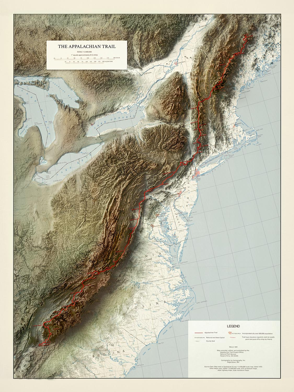
La Appalachian Trail - Mappa in rilievo 3D della The Unique Maps Co. è un capolavoro cartografico, che fonde l'arte della mappatura...
Continua a leggereLa Appalachian Trail - Mappa in rilievo 3D della The Unique Maps Co. è un capolavoro cartografico, che fonde l'arte della mappatura tradizionale con la tecnologia all'avanguardia. Ispirata a un originale vintage prodotto dal National Park Service degli Stati Uniti, questa edizione del 2025 è stata meticolosamente aggiornata utilizzando immagini satellitari ad alta risoluzione e i più recenti dati topografici. Il risultato è una mappa in rilievo 3D incredibilmente realistica che cattura la bellezza aspra e le elevate altitudini delle Montagne Appalache, che si estendono dalle colline ondulate della Georgia alle terre selvagge del Maine settentrionale. Il titolo originale della mappa, una testimonianza del suo patrimonio e della sua autorità, segna le sue radici nella grande tradizione dell'esplorazione e della conservazione americana.
The Unique Maps Co., rinomata per la sua dedizione sia all'autenticità storica che all'innovazione visiva, ha creato una mappa che è tanto un'opera d'arte quanto uno strumento di navigazione. Il loro approccio combina una ricerca meticolosa con un rendering digitale avanzato, producendo un pezzo che evidenzia non solo i contorni fisici della terra ma anche lo spirito duraturo dell'Appalachian Trail. Ogni dettaglio—dall'ombreggiatura sottile delle valli alla linea rossa audace che segna il percorso tortuoso del sentiero—riflette una profonda riverenza per il paesaggio e il suo passato ricco di storie.
Questa mappa offre una vista panoramica degli Stati Uniti orientali, comprendente una vasta gamma di meraviglie naturali e regioni storiche. Il sentiero stesso è fiancheggiato da parchi nazionali iconici come le Great Smoky Mountains e Shenandoah, così come foreste leggendarie come le White Mountain e Green Mountain National Forests. Fiumi maestosi, tra cui l'Hudson, il Connecticut e il Susquehanna, si snodano attraverso il terreno, mentre il blu scintillante dei Laghi Erie, Ontario e Huron ancorano il bordo occidentale della mappa. Lo stile in rilievo dà vita alle creste ondulate delle Blue Ridge e Catskill Mountains, invitando l'osservatore a tracciare il viaggio dal Springer Mountain al Mount Katahdin.
Oltre alla sua grandezza naturale, la mappa è una finestra sul tessuto culturale e storico della regione appalachiana. Le città del sentiero messe in evidenza—molte delle quali sono diventate leggendarie tra i camminatori—servono da porte d'accesso alle diverse comunità, tradizioni e storie che hanno plasmato l'eredità del sentiero. Grandi città come Atlanta, Washington D.C. e Pittsburgh sono rappresentate accanto a storiche città più piccole come Harpers Ferry e Damascus, illustrando l'unicità del sentiero nel collegare l'America urbana e rurale. Ogni insediamento è posizionato con cura, riflettendo sia la sua importanza moderna che il suo ruolo storico nello sviluppo della regione.
L'Appalachian Trail stesso si erge come un monumento alla perseveranza e alla visione americana, concepito all'inizio del XX secolo come un sentiero continuo attraverso il cuore selvaggio dell'Est. Questa mappa non solo tracciava il suo corso fisico ma evoca anche il senso di avventura e scoperta che ha attratto generazioni di escursionisti sul suo cammino. Che venga esposta come un pezzo d'affermazione o studiata per la sua ricchezza di dettagli geografici e storici, La Appalachian Trail - Mappa in rilievo 3D della The Unique Maps Co. è un invito a esplorare, ricordare e celebrare uno dei più grandi tesori naturali d'America.
Città e paesi su questa mappa
- Atlanta, Georgia
- Washington, D.C.
- Pittsburgh, Pennsylvania
- Charlotte, Carolina del Nord
- Knoxville, Tennessee
- Roanoke, Virginia
- Harrisburg, Pennsylvania
- Asheville, Carolina del Nord
- Chattanooga, Tennessee
- Scranton, Pennsylvania
- Frederick, Maryland
- Lynchburg, Virginia
- Johnson City, Tennessee
- Hagerstown, Maryland
- Hanover, New Hampshire
- Rutland, Vermont
- Bennington, Vermont
- Dalton, Massachusetts
- Damascus, Virginia
- Harpers Ferry, West Virginia
Caratteristiche e monumenti notevoli
- Appalachian Trail (chiaramente segnato in rosso)
- Parco Nazionale delle Great Smoky Mountains
- Parco Nazionale dello Shenandoah
- Foresta Nazionale delle White Mountains
- Foresta Nazionale delle Green Mountains
- Parco Statale di Baxter (luogo del Monte Katahdin)
- Monte Springer (termine meridionale del sentiero)
- Monte Katahdin (termine settentrionale del sentiero)
- Montagne Blue Ridge
- Montagne Catskill
- Montagne Adirondack (visibili ma il sentiero non passa direttamente attraverso)
- Fiumi principali chiaramente visibili, tra cui il fiume Hudson, il fiume Connecticut e il fiume Susquehanna
- Lago Erie, Ontario e Huron (parzialmente visibili sul bordo sinistro della mappa)
Contesto storico e di design
- Basato su una mappa vintage del "Servizio Nazionale dei Parchi degli Stati Uniti, Ufficio del Progetto Appalachian Trail," aggiornata nel 2025 con immagini satellitari ad alta risoluzione e dati topografici.
- The Unique Maps Co., rinomata per la sua dedizione sia all'autenticità storica che all'innovazione visiva, ha creato questa mappa.
- Stile di rilievo 3D realistico, visivamente accattivante, enfatizzando i dettagli topografici e l'elevazione.
- Il Appalachian Trail è un sentiero escursionistico a lunga distanza storicamente significativo, istituito all'inizio del XX secolo, che si estende per circa 2.190 miglia attraverso ecosistemi e paesaggi diversi.
- Il titolo originale della mappa è "The Appalachian Trail - Mappa 3D in Rilievo di The Unique Maps Co."
- La mappa copre la costa orientale degli Stati Uniti, da Monte Springer in Georgia a Monte Katahdin nel Maine, inclusi parti della regione dei Grandi Laghi.
Si prega di controllare attentamente le immagini per assicurarsi che una specifica città o luogo sia mostrato su questa mappa. Puoi anche contattarci e chiedere di controllare la mappa per te.
Questa mappa appare fantastica in ogni dimensione, ma consiglio sempre di optare per una dimensione più grande se hai spazio. In questo modo puoi facilmente distinguere tutti i dettagli.
Questa mappa appare sorprendente in dimensioni fino a 70in (180cm). Se stai cercando una mappa più grande, per favore contattaci.
Il modello nelle immagini dell'elenco tiene la versione 18x24in (45x60cm) di questa mappa.
La quinta immagine dell'elenco mostra un esempio del mio servizio di personalizzazione della mappa.
Se stai cercando qualcosa di leggermente diverso, dai un'occhiata alla mia collezione delle migliori mappe antiche per vedere se qualcosa cattura la tua attenzione.
Si prega di contattarmi per verificare se una certa posizione, monumento o caratteristica è mostrata su questa mappa.
Questo sarebbe un meraviglioso regalo per un compleanno, Natale, Festa del Papà, un addio al lavoro, un anniversario o una festa di inaugurazione per qualcuno delle aree coperte da questa mappa.
Informazioni sulle nostre Uniche Mappe Topografiche in Rilievo 3D
Queste non sono solo mappe — sono paesaggi, scolpiti con luce e ombra.
Le nostre stampe in rilievo ombreggiato utilizzano dati topografici ad altissima risoluzione e un processo di rendering 3D segreto per creare l'illusione di un terreno sollevato — come se le montagne stessero per sollevarsi dalla pagina. Ma si prega di notare che questa mappa è in realtà 2D — sembra solo veramente 3D, particolarmente quando è incorniciata dietro vetro.
Sono progettate per avere un aspetto senza tempo. Abbastanza audaci da essere un pezzo centrale, abbastanza sottili da integrarsi. Un regalo perfetto per gli amanti delle mappe, i viandanti delle montagne o chiunque trovi bellezza nella forma della Terra.
E naturalmente, come tutte le nostre altre mappe, puoi personalizzare anche questa mappa topografica. Perché non segnare le tue vette preferite o i percorsi delle tue escursioni e gite in bicicletta preferite?
Questa mappa è disponibile come stampa giclée su carta opaca archiviabile priva di acidi, oppure puoi acquistarla incorniciata. La cornice è una bella e semplice cornice nera che si adatta alla maggior parte degli stili. Ti preghiamo di contattarci se desideri un colore o un materiale della cornice diverso. Le mie cornici sono rivestite con acrilico super chiaro di grado museale (perspex/acrylite), che è significativamente meno riflettente del vetro, più sicuro e arriverà sempre in perfette condizioni.
This map is also available as a float framed canvas, sometimes known as a shadow gap framed canvas or canvas floater. The map is printed on artist's cotton canvas and then stretched over a handmade box frame. We then "float" the canvas inside a wooden frame, which is available in a range of colours (black, dark brown, oak, antique gold and white). This is a wonderful way to present a map without glazing in front. See some examples of float framed canvas maps and explore the differences between my different finishes.
La Appalachian Trail - Mappa in rilievo 3D della The Unique Maps Co. è un capolavoro cartografico, che fonde l'arte della mappatura tradizionale con la tecnologia all'avanguardia. Ispirata a un originale vintage prodotto dal National Park Service degli Stati Uniti, questa edizione del 2025 è stata meticolosamente aggiornata utilizzando immagini satellitari ad alta risoluzione e i più recenti dati topografici. Il risultato è una mappa in rilievo 3D incredibilmente realistica che cattura la bellezza aspra e le elevate altitudini delle Montagne Appalache, che si estendono dalle colline ondulate della Georgia alle terre selvagge del Maine settentrionale. Il titolo originale della mappa, una testimonianza del suo patrimonio e della sua autorità, segna le sue radici nella grande tradizione dell'esplorazione e della conservazione americana.
The Unique Maps Co., rinomata per la sua dedizione sia all'autenticità storica che all'innovazione visiva, ha creato una mappa che è tanto un'opera d'arte quanto uno strumento di navigazione. Il loro approccio combina una ricerca meticolosa con un rendering digitale avanzato, producendo un pezzo che evidenzia non solo i contorni fisici della terra ma anche lo spirito duraturo dell'Appalachian Trail. Ogni dettaglio—dall'ombreggiatura sottile delle valli alla linea rossa audace che segna il percorso tortuoso del sentiero—riflette una profonda riverenza per il paesaggio e il suo passato ricco di storie.
Questa mappa offre una vista panoramica degli Stati Uniti orientali, comprendente una vasta gamma di meraviglie naturali e regioni storiche. Il sentiero stesso è fiancheggiato da parchi nazionali iconici come le Great Smoky Mountains e Shenandoah, così come foreste leggendarie come le White Mountain e Green Mountain National Forests. Fiumi maestosi, tra cui l'Hudson, il Connecticut e il Susquehanna, si snodano attraverso il terreno, mentre il blu scintillante dei Laghi Erie, Ontario e Huron ancorano il bordo occidentale della mappa. Lo stile in rilievo dà vita alle creste ondulate delle Blue Ridge e Catskill Mountains, invitando l'osservatore a tracciare il viaggio dal Springer Mountain al Mount Katahdin.
Oltre alla sua grandezza naturale, la mappa è una finestra sul tessuto culturale e storico della regione appalachiana. Le città del sentiero messe in evidenza—molte delle quali sono diventate leggendarie tra i camminatori—servono da porte d'accesso alle diverse comunità, tradizioni e storie che hanno plasmato l'eredità del sentiero. Grandi città come Atlanta, Washington D.C. e Pittsburgh sono rappresentate accanto a storiche città più piccole come Harpers Ferry e Damascus, illustrando l'unicità del sentiero nel collegare l'America urbana e rurale. Ogni insediamento è posizionato con cura, riflettendo sia la sua importanza moderna che il suo ruolo storico nello sviluppo della regione.
L'Appalachian Trail stesso si erge come un monumento alla perseveranza e alla visione americana, concepito all'inizio del XX secolo come un sentiero continuo attraverso il cuore selvaggio dell'Est. Questa mappa non solo tracciava il suo corso fisico ma evoca anche il senso di avventura e scoperta che ha attratto generazioni di escursionisti sul suo cammino. Che venga esposta come un pezzo d'affermazione o studiata per la sua ricchezza di dettagli geografici e storici, La Appalachian Trail - Mappa in rilievo 3D della The Unique Maps Co. è un invito a esplorare, ricordare e celebrare uno dei più grandi tesori naturali d'America.
Città e paesi su questa mappa
- Atlanta, Georgia
- Washington, D.C.
- Pittsburgh, Pennsylvania
- Charlotte, Carolina del Nord
- Knoxville, Tennessee
- Roanoke, Virginia
- Harrisburg, Pennsylvania
- Asheville, Carolina del Nord
- Chattanooga, Tennessee
- Scranton, Pennsylvania
- Frederick, Maryland
- Lynchburg, Virginia
- Johnson City, Tennessee
- Hagerstown, Maryland
- Hanover, New Hampshire
- Rutland, Vermont
- Bennington, Vermont
- Dalton, Massachusetts
- Damascus, Virginia
- Harpers Ferry, West Virginia
Caratteristiche e monumenti notevoli
- Appalachian Trail (chiaramente segnato in rosso)
- Parco Nazionale delle Great Smoky Mountains
- Parco Nazionale dello Shenandoah
- Foresta Nazionale delle White Mountains
- Foresta Nazionale delle Green Mountains
- Parco Statale di Baxter (luogo del Monte Katahdin)
- Monte Springer (termine meridionale del sentiero)
- Monte Katahdin (termine settentrionale del sentiero)
- Montagne Blue Ridge
- Montagne Catskill
- Montagne Adirondack (visibili ma il sentiero non passa direttamente attraverso)
- Fiumi principali chiaramente visibili, tra cui il fiume Hudson, il fiume Connecticut e il fiume Susquehanna
- Lago Erie, Ontario e Huron (parzialmente visibili sul bordo sinistro della mappa)
Contesto storico e di design
- Basato su una mappa vintage del "Servizio Nazionale dei Parchi degli Stati Uniti, Ufficio del Progetto Appalachian Trail," aggiornata nel 2025 con immagini satellitari ad alta risoluzione e dati topografici.
- The Unique Maps Co., rinomata per la sua dedizione sia all'autenticità storica che all'innovazione visiva, ha creato questa mappa.
- Stile di rilievo 3D realistico, visivamente accattivante, enfatizzando i dettagli topografici e l'elevazione.
- Il Appalachian Trail è un sentiero escursionistico a lunga distanza storicamente significativo, istituito all'inizio del XX secolo, che si estende per circa 2.190 miglia attraverso ecosistemi e paesaggi diversi.
- Il titolo originale della mappa è "The Appalachian Trail - Mappa 3D in Rilievo di The Unique Maps Co."
- La mappa copre la costa orientale degli Stati Uniti, da Monte Springer in Georgia a Monte Katahdin nel Maine, inclusi parti della regione dei Grandi Laghi.
Si prega di controllare attentamente le immagini per assicurarsi che una specifica città o luogo sia mostrato su questa mappa. Puoi anche contattarci e chiedere di controllare la mappa per te.
Questa mappa appare fantastica in ogni dimensione, ma consiglio sempre di optare per una dimensione più grande se hai spazio. In questo modo puoi facilmente distinguere tutti i dettagli.
Questa mappa appare sorprendente in dimensioni fino a 70in (180cm). Se stai cercando una mappa più grande, per favore contattaci.
Il modello nelle immagini dell'elenco tiene la versione 18x24in (45x60cm) di questa mappa.
La quinta immagine dell'elenco mostra un esempio del mio servizio di personalizzazione della mappa.
Se stai cercando qualcosa di leggermente diverso, dai un'occhiata alla mia collezione delle migliori mappe antiche per vedere se qualcosa cattura la tua attenzione.
Si prega di contattarmi per verificare se una certa posizione, monumento o caratteristica è mostrata su questa mappa.
Questo sarebbe un meraviglioso regalo per un compleanno, Natale, Festa del Papà, un addio al lavoro, un anniversario o una festa di inaugurazione per qualcuno delle aree coperte da questa mappa.
Informazioni sulle nostre Uniche Mappe Topografiche in Rilievo 3D
Queste non sono solo mappe — sono paesaggi, scolpiti con luce e ombra.
Le nostre stampe in rilievo ombreggiato utilizzano dati topografici ad altissima risoluzione e un processo di rendering 3D segreto per creare l'illusione di un terreno sollevato — come se le montagne stessero per sollevarsi dalla pagina. Ma si prega di notare che questa mappa è in realtà 2D — sembra solo veramente 3D, particolarmente quando è incorniciata dietro vetro.
Sono progettate per avere un aspetto senza tempo. Abbastanza audaci da essere un pezzo centrale, abbastanza sottili da integrarsi. Un regalo perfetto per gli amanti delle mappe, i viandanti delle montagne o chiunque trovi bellezza nella forma della Terra.
E naturalmente, come tutte le nostre altre mappe, puoi personalizzare anche questa mappa topografica. Perché non segnare le tue vette preferite o i percorsi delle tue escursioni e gite in bicicletta preferite?
Questa mappa è disponibile come stampa giclée su carta opaca archiviabile priva di acidi, oppure puoi acquistarla incorniciata. La cornice è una bella e semplice cornice nera che si adatta alla maggior parte degli stili. Ti preghiamo di contattarci se desideri un colore o un materiale della cornice diverso. Le mie cornici sono rivestite con acrilico super chiaro di grado museale (perspex/acrylite), che è significativamente meno riflettente del vetro, più sicuro e arriverà sempre in perfette condizioni.
This map is also available as a float framed canvas, sometimes known as a shadow gap framed canvas or canvas floater. The map is printed on artist's cotton canvas and then stretched over a handmade box frame. We then "float" the canvas inside a wooden frame, which is available in a range of colours (black, dark brown, oak, antique gold and white). This is a wonderful way to present a map without glazing in front. See some examples of float framed canvas maps and explore the differences between my different finishes.
Many of our maps and art prints are chosen as thoughtful gifts for homes, offices, studies and meaningful places.
Choose a framed option for the easiest ready-to-hang gift, or choose an unframed print if the recipient may prefer to select their own frame.
We make orders locally in 23 countries around the world, so gifts can often be produced close to the recipient. This helps them arrive faster, travel more safely, and avoid customs or import duty surprises.
- We can deliver directly to the recipient
- Framed pieces arrive ready to hang
- Unframed prints are carefully packed in a strong protective tube
- Almost every order is made locally, for faster, safer gifting
- 90-day returns give the recipient time to decide
If you are not sure what to choose, please contact us. We can help you pick the right map, size, finish or delivery option.
Most orders are made locally and delivered in around 2–3 working days, depending on the product, size and destination.
We print and frame maps and artwork in 23 countries around the world, so your order is usually made close to you or your recipient. That means faster delivery, less time in transit, and no customs or import duty surprises.
Personalised and customised pieces usually take an extra 1–2 working days, because we prepare your design and send it to you for approval before printing.
Very large framed orders can take a little longer, as they need extra care in production and delivery.
Every order is carefully packaged: unframed prints are sent in a strong protective tube, while framed pieces are securely packed with protective materials around the frame.
If you need your order by a particular date, please contact us before ordering. We’ll check the best production route and delivery option for your location.
Express delivery is available at checkout for most countries. Next-day delivery is available in the UK, US, Singapore and the UAE.
Your order is covered by our 90-day returns policy and 10-year guarantee.
Our standard frame is a gallery-style black ash hardwood frame, with a simple, modern look. It is approximately 20mm (0.8in) wide. You can also view some lovely customer photos of framed maps and art.
We use super-clear acrylic glazing, also known as Perspex or Acrylite, instead of traditional glass. It is lighter, safer, and has lower reflectivity, giving the artwork a clearer, cleaner appearance.
Six standard frame colours are available at no extra cost: black, dark brown, dark grey, oak, white, and antique gold. Custom framing and mounting/matting is also available for customers looking for something more specific.
Most maps, art prints, and illustrations are also available as a framed canvas. We use matte cotton canvas, stretch it over a sustainably sourced wooden box frame, and then float the piece within a wooden outer frame. The finished result is beautifully presented, with no glazing between you and the artwork.
All frames are supplied ready to hang, with either string or brackets fitted to the back. Very large frames will include heavy-duty hanging plates and/or a mounting baton. If you have any questions, please get in touch.
We can also supply old maps and artwork on canvas, foam board, cotton rag, and other materials.
If you would prefer to frame your map or artwork yourself, please read our size guide before ordering.
My maps are extremely high quality reproductions of original maps.
I source original, rare maps from libraries, auction houses and private collections around the world, restore them at my London workshop, and then use specialist giclée inks and printers to create beautiful maps that look even better than the original.
My maps are printed on acid-free archival matte (not glossy) paper that feels very high quality and almost like card. In technical terms the paper weight/thickness is 10mil/200gsm. It's perfect for framing.
I print with Epson ultrachrome giclée UV fade resistant pigment inks - some of the best inks you can find.
I can also make maps on canvas, cotton rag and other exotic materials.
Learn more about The Unique Maps Co.
Map personalisation
If you're looking for the perfect anniversary or housewarming gift, I can personalise your map to make it truly unique. For example, I can add a short message, or highlight an important location, or add your family's coat of arms.
The options are almost infinite. Please see my map personalisation page for some wonderful examples of what's possible.
To order a personalised map, select "personalise your map" before adding it to your basket.
Get in touch if you're looking for more complex customisations and personalisations.
Map ageing
I have been asked hundreds of times over the years by customers if they could buy a map that looks even older.
Well, now you can, by selecting Aged before you add a map to your basket.
All the product photos you see on this page show the map in its Original form. This is what the map looks like today.
If you select Aged, I will age your map by hand, using a special and unique process developed through years of studying old maps, talking to researchers to understand the chemistry of aging paper, and of course... lots of practice!
If you're unsure, stick to the Original colour of the map. If you want something a bit darker and older looking, go for Aged.
Se non sei soddisfatto del tuo ordine per qualsiasi motivo, contattami per un rimborso senza problemi. Si prega di consultare la nostra politica di reso e rimborso per ulteriori informazioni.
Sono molto sicuro che ti piacerà la tua mappa restaurata o la stampa d'arte. Lo faccio dal 1984. Sono un venditore Etsy a 5 stelle. Ho venduto decine di migliaia di mappe e stampe d'arte e ho oltre 5.000 recensioni reali a 5 stelle.
Utilizzo un processo unico per restaurare mappe e opere d'arte che richiede molto tempo e lavoro. Trovare le mappe e le illustrazioni originali può richiedere mesi. Utilizzo tecnologia all'avanguardia e incredibilmente costosa per scannerizzare e restaurarle. Di conseguenza, garantisco che le mie mappe e stampe d'arte siano superiori alle altre - ecco perché posso offrire un rimborso senza problemi.
Quasi tutte le mie mappe e stampe d'arte sembrano fantastiche a grandi dimensioni (200 cm, 6,5 piedi+) e posso anche incorniciarle e consegnarle a te, tramite un corriere speciale per oggetti di grandi dimensioni. Contattami per discutere delle tue esigenze specifiche.
Or try searching for something!


