

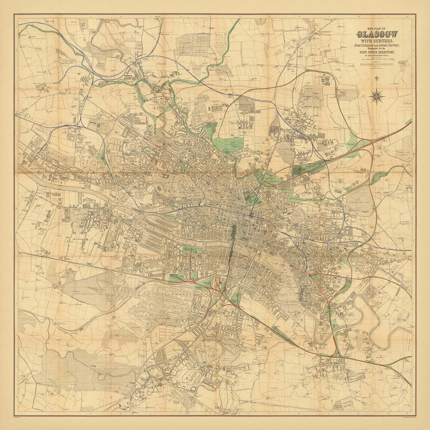


Large Map of Glasgow by Bartholomew, 1903: Railroads, River Clyde, Parks
20% off 2 — 33% off 3
Add any two eligible items to your bag to receive 20% off. Add a third and it will be complimentary (equivalent to 33% off when purchasing three).
No code needed — the offer applies automatically at checkout.
Valid on all standard maps and fine art prints. You can mix and match any designs.
If you’d like to ship items to multiple addresses, please contact us before placing your order.
Custom and bespoke commissions are excluded.
Contact us if you have any questions
 Designed in London Made in Australia
Designed in London • Made in Australia
Designed in London Made in Australia
Designed in London • Made in Australia

Restored from the original 1903 map and printed to museum-grade archival standards. Read the story behind this map
Choose your size
Choose your finish


(More info)
Gift message & custom finish

If you want to add a gift message, or a finish (jigsaw, aluminium board, etc.) that is not available here, please request it in the "order note" when you check out.
Every order is custom made, so if you need the size adjusted slightly, or printed on an unusual material, just let us know. We've done thousands of custom orders over the years, so there's (almost) nothing we can't manage.
You can also contact us before you order, if you prefer!

- Made locally for fast, safe delivery
- No import duty or hidden fees
- Need advice? Call us or message on WhatsApp
Own a piece of history
8,000+ five-star reviews


The "New Plan of Glasgow with Suburbs," crafted in 1903 by the esteemed Edinburgh-based mapmaker John Bartholomew & Co., is a remarkable...
Continue readingThe "New Plan of Glasgow with Suburbs," crafted in 1903 by the esteemed Edinburgh-based mapmaker John Bartholomew & Co., is a remarkable testament to the urban and transportation evolution of early 20th-century Glasgow. This exquisite map offers a window into the past, showcasing the intricate network of streets and railroads that defined the city’s landscape. Bartholomew’s meticulous attention to detail is evident in the way he captures the essence of Glasgow, a city bustling with industrial growth and cultural vibrancy.
John Bartholomew, a renowned figure in the world of cartography, was celebrated for his precision and artistry. His maps were not merely functional; they were works of art that combined accuracy with aesthetic appeal. This particular map of Glasgow highlights his ability to convey complex urban environments with clarity and elegance. Bartholomew’s legacy in cartography is reflected in the enduring value of his maps, which continue to captivate historians and collectors alike.
Glasgow, a city steeped in history and innovation, is brought to life through this map’s depiction of its significant neighborhoods and landmarks. The map intricately details areas such as Argyle Street and Buchanan Street, capturing the vibrant commercial heart of the city. The River Clyde, a lifeline for Glasgow’s shipbuilding industry, winds its way through the map, symbolizing the city’s industrial prowess and its connection to global trade routes.
The inclusion of extensive railroad lines highlights Glasgow’s role as a transportation hub during this period. The railroads not only facilitated the movement of goods and people but also spurred the growth of suburbs, as depicted in the map. This network underscores the city’s dynamic expansion and its strategic importance in Scotland’s economic landscape. Bartholomew’s map elegantly illustrates these developments, offering a snapshot of a city on the cusp of modernity.
Beyond its urban core, the map reveals green spaces and parks that provided respite from the bustling city life. These areas, alongside the detailed depiction of Glasgow’s streets and infrastructure, reflect the city’s commitment to balancing industrial growth with quality of life. This map is not just a tool for navigation; it is a historical document that captures the spirit of Glasgow at a pivotal moment in its history, making it a valuable addition to any collection of historical maps.
Streets and roads on this map
- Argyle Street
- Bath Street
- Buchanan Street
- Duke Street
- Great Western Road
- High Street
- Hope Street
- Jamaica Street
- London Road
- Sauchiehall Street
Notable Features & Landmarks
- Railroads: Extensive network of railroad lines throughout the city and suburbs.
- Parks: Several green areas indicating parks or open spaces.
- Rivers: The River Clyde is prominently featured.
- Neighborhoods: Various districts and suburbs of Glasgow are labeled.
Historical and design context
- Name of the map: New Plan of Glasgow with Suburbs
- Date of creation: 1903
- Mapmaker/Publisher: John Bartholomew & Co.
- Themes and topics:
- City street layout and infrastructure.
- Railroad connections and routes.
- Urban planning and development of Glasgow and its suburbs.
- Design or style context:
- Large format with detailed illustrations of streets and railroads.
- Reflects early 20th-century cartographic techniques.
- Historical significance:
- Provides insight into the urban and transportation development of Glasgow in the early 1900s.
Please double check the images to make sure that a specific town or place is shown on this map. You can also get in touch and ask us to check the map for you.
This is a very large map that must be ordered at a large size, so that you can easily make out all of the details.
This map looks amazing at sizes all the way up to 100in (250cm). If you are looking for a larger map, please get in touch.
The model in the listing images is holding the 16x16in (40x40cm) version of this map.
The fifth listing image shows an example of my map personalisation service.
If you’re looking for something slightly different, check out my collection of the best old maps to see if something else catches your eye.
Please contact me to check if a certain location, landmark or feature is shown on this map.
This would make a wonderful birthday, Christmas, Father's Day, work leaving, anniversary or housewarming gift for someone from the areas covered by this map.
This map is available as a giclée print on acid free archival matte paper, or you can buy it framed. The frame is a nice, simple black frame that suits most aesthetics. Please get in touch if you'd like a different frame colour or material. My frames are glazed with super-clear museum-grade acrylic (perspex/acrylite), which is significantly less reflective than glass, safer, and will always arrive in perfect condition.
This map is also available as a float framed canvas, sometimes known as a shadow gap framed canvas or canvas floater. The map is printed on artist's cotton canvas and then stretched over a handmade box frame. We then "float" the canvas inside a wooden frame, which is available in a range of colours (black, dark brown, oak, antique gold and white). This is a wonderful way to present a map without glazing in front. See some examples of float framed canvas maps and explore the differences between my different finishes.
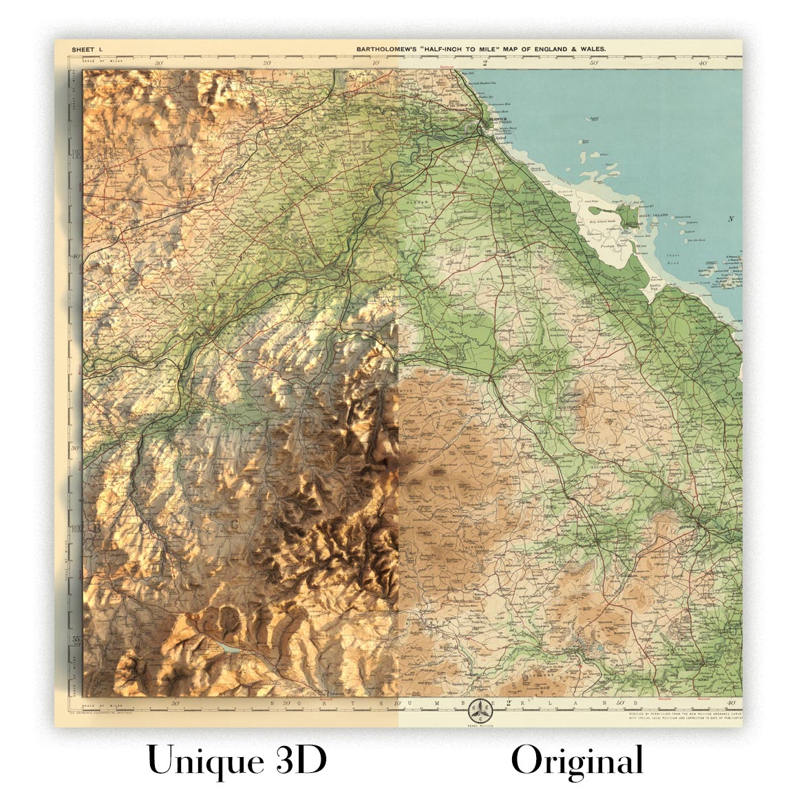
For something truly unique, this map is also available in "Unique 3D", our trademarked process that dramatically transforms the map so that it has a wonderful sense of depth. We combine the original map with detailed topography and elevation data, so that mountains and the terrain really "pop". For more info and examples of 3D maps, check my Unique 3D page.
The "New Plan of Glasgow with Suburbs," crafted in 1903 by the esteemed Edinburgh-based mapmaker John Bartholomew & Co., is a remarkable testament to the urban and transportation evolution of early 20th-century Glasgow. This exquisite map offers a window into the past, showcasing the intricate network of streets and railroads that defined the city’s landscape. Bartholomew’s meticulous attention to detail is evident in the way he captures the essence of Glasgow, a city bustling with industrial growth and cultural vibrancy.
John Bartholomew, a renowned figure in the world of cartography, was celebrated for his precision and artistry. His maps were not merely functional; they were works of art that combined accuracy with aesthetic appeal. This particular map of Glasgow highlights his ability to convey complex urban environments with clarity and elegance. Bartholomew’s legacy in cartography is reflected in the enduring value of his maps, which continue to captivate historians and collectors alike.
Glasgow, a city steeped in history and innovation, is brought to life through this map’s depiction of its significant neighborhoods and landmarks. The map intricately details areas such as Argyle Street and Buchanan Street, capturing the vibrant commercial heart of the city. The River Clyde, a lifeline for Glasgow’s shipbuilding industry, winds its way through the map, symbolizing the city’s industrial prowess and its connection to global trade routes.
The inclusion of extensive railroad lines highlights Glasgow’s role as a transportation hub during this period. The railroads not only facilitated the movement of goods and people but also spurred the growth of suburbs, as depicted in the map. This network underscores the city’s dynamic expansion and its strategic importance in Scotland’s economic landscape. Bartholomew’s map elegantly illustrates these developments, offering a snapshot of a city on the cusp of modernity.
Beyond its urban core, the map reveals green spaces and parks that provided respite from the bustling city life. These areas, alongside the detailed depiction of Glasgow’s streets and infrastructure, reflect the city’s commitment to balancing industrial growth with quality of life. This map is not just a tool for navigation; it is a historical document that captures the spirit of Glasgow at a pivotal moment in its history, making it a valuable addition to any collection of historical maps.
Streets and roads on this map
- Argyle Street
- Bath Street
- Buchanan Street
- Duke Street
- Great Western Road
- High Street
- Hope Street
- Jamaica Street
- London Road
- Sauchiehall Street
Notable Features & Landmarks
- Railroads: Extensive network of railroad lines throughout the city and suburbs.
- Parks: Several green areas indicating parks or open spaces.
- Rivers: The River Clyde is prominently featured.
- Neighborhoods: Various districts and suburbs of Glasgow are labeled.
Historical and design context
- Name of the map: New Plan of Glasgow with Suburbs
- Date of creation: 1903
- Mapmaker/Publisher: John Bartholomew & Co.
- Themes and topics:
- City street layout and infrastructure.
- Railroad connections and routes.
- Urban planning and development of Glasgow and its suburbs.
- Design or style context:
- Large format with detailed illustrations of streets and railroads.
- Reflects early 20th-century cartographic techniques.
- Historical significance:
- Provides insight into the urban and transportation development of Glasgow in the early 1900s.
Please double check the images to make sure that a specific town or place is shown on this map. You can also get in touch and ask us to check the map for you.
This is a very large map that must be ordered at a large size, so that you can easily make out all of the details.
This map looks amazing at sizes all the way up to 100in (250cm). If you are looking for a larger map, please get in touch.
The model in the listing images is holding the 16x16in (40x40cm) version of this map.
The fifth listing image shows an example of my map personalisation service.
If you’re looking for something slightly different, check out my collection of the best old maps to see if something else catches your eye.
Please contact me to check if a certain location, landmark or feature is shown on this map.
This would make a wonderful birthday, Christmas, Father's Day, work leaving, anniversary or housewarming gift for someone from the areas covered by this map.
This map is available as a giclée print on acid free archival matte paper, or you can buy it framed. The frame is a nice, simple black frame that suits most aesthetics. Please get in touch if you'd like a different frame colour or material. My frames are glazed with super-clear museum-grade acrylic (perspex/acrylite), which is significantly less reflective than glass, safer, and will always arrive in perfect condition.
This map is also available as a float framed canvas, sometimes known as a shadow gap framed canvas or canvas floater. The map is printed on artist's cotton canvas and then stretched over a handmade box frame. We then "float" the canvas inside a wooden frame, which is available in a range of colours (black, dark brown, oak, antique gold and white). This is a wonderful way to present a map without glazing in front. See some examples of float framed canvas maps and explore the differences between my different finishes.
For something truly unique, this map is also available in "Unique 3D", our trademarked process that dramatically transforms the map so that it has a wonderful sense of depth. We combine the original map with detailed topography and elevation data, so that mountains and the terrain really "pop". For more info and examples of 3D maps, check my Unique 3D page.
Many of our maps and art prints are chosen as thoughtful gifts for homes, offices, studies and meaningful places.
Choose a framed option for the easiest ready-to-hang gift, or choose an unframed print if the recipient may prefer to select their own frame.
We make orders locally in 23 countries around the world, so gifts can often be produced close to the recipient. This helps them arrive faster, travel more safely, and avoid customs or import duty surprises.
- We can deliver directly to the recipient
- Framed pieces arrive ready to hang
- Unframed prints are carefully packed in a strong protective tube
- Almost every order is made locally, for faster, safer gifting
- 90-day returns give the recipient time to decide
If you are not sure what to choose, please contact us. We can help you pick the right map, size, finish or delivery option.
Most orders are made locally and delivered in around 2–3 working days, depending on the product, size and destination.
We print and frame maps and artwork in 23 countries around the world, so your order is usually made close to you or your recipient. That means faster delivery, less time in transit, and no customs or import duty surprises.
Personalised and customised pieces usually take an extra 1–2 working days, because we prepare your design and send it to you for approval before printing.
Very large framed orders can take a little longer, as they need extra care in production and delivery.
Every order is carefully packaged: unframed prints are sent in a strong protective tube, while framed pieces are securely packed with protective materials around the frame.
If you need your order by a particular date, please contact us before ordering. We’ll check the best production route and delivery option for your location.
Express delivery is available at checkout for most countries. Next-day delivery is available in the UK, US, Singapore and the UAE.
Your order is covered by our 90-day returns policy and 10-year guarantee.
Our standard frame is a gallery-style black ash hardwood frame, with a simple, modern look. It is approximately 20mm (0.8in) wide. You can also view some lovely customer photos of framed maps and art.
We use super-clear acrylic glazing, also known as Perspex or Acrylite, instead of traditional glass. It is lighter, safer, and has lower reflectivity, giving the artwork a clearer, cleaner appearance.
Six standard frame colours are available at no extra cost: black, dark brown, dark grey, oak, white, and antique gold. Custom framing and mounting/matting is also available for customers looking for something more specific.
Most maps, art prints, and illustrations are also available as a framed canvas. We use matte cotton canvas, stretch it over a sustainably sourced wooden box frame, and then float the piece within a wooden outer frame. The finished result is beautifully presented, with no glazing between you and the artwork.
All frames are supplied ready to hang, with either string or brackets fitted to the back. Very large frames will include heavy-duty hanging plates and/or a mounting baton. If you have any questions, please get in touch.
We can also supply old maps and artwork on canvas, foam board, cotton rag, and other materials.
If you would prefer to frame your map or artwork yourself, please read our size guide before ordering.
My maps are extremely high quality reproductions of original maps.
I source original, rare maps from libraries, auction houses and private collections around the world, restore them at my London workshop, and then use specialist giclée inks and printers to create beautiful maps that look even better than the original.
My maps are printed on acid-free archival matte (not glossy) paper that feels very high quality and almost like card. In technical terms the paper weight/thickness is 10mil/200gsm. It's perfect for framing.
I print with Epson ultrachrome giclée UV fade resistant pigment inks - some of the best inks you can find.
I can also make maps on canvas, cotton rag and other exotic materials.
Learn more about The Unique Maps Co.
Map personalisation
If you're looking for the perfect anniversary or housewarming gift, I can personalise your map to make it truly unique. For example, I can add a short message, or highlight an important location, or add your family's coat of arms.
The options are almost infinite. Please see my map personalisation page for some wonderful examples of what's possible.
To order a personalised map, select "personalise your map" before adding it to your basket.
Get in touch if you're looking for more complex customisations and personalisations.
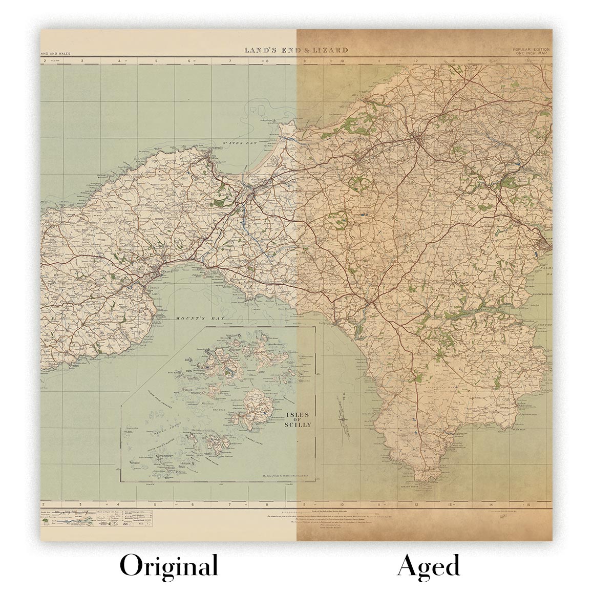
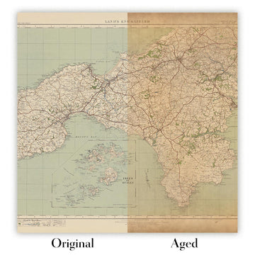
Map ageing
I have been asked hundreds of times over the years by customers if they could buy a map that looks even older.
Well, now you can, by selecting Aged before you add a map to your basket.
All the product photos you see on this page show the map in its Original form. This is what the map looks like today.
If you select Aged, I will age your map by hand, using a special and unique process developed through years of studying old maps, talking to researchers to understand the chemistry of aging paper, and of course... lots of practice!
If you're unsure, stick to the Original colour of the map. If you want something a bit darker and older looking, go for Aged.
If you are not happy with your order for any reason, contact me and I'll get it fixed ASAP, free of charge. Please see my returns and refund policy for more information.
I am very confident you will like your restored map or art print. I have been doing this since 1984. I'm a 5-star Etsy seller. I have sold tens of thousands of maps and art prints and have over 5,000 real 5-star reviews. My work has been featured in interior design magazines, on the BBC, and on the walls of dozens of 5-star hotels.
I use a unique process to restore maps and artwork that is massively time consuming and labour intensive. Hunting down the original maps and illustrations can take months. I use state of the art and eye-wateringly expensive technology to scan and restore them. As a result, I guarantee my maps and art prints are a cut above the rest. I stand by my products and will always make sure you're 100% happy with what you receive.
Almost all of my maps and art prints look amazing at large sizes (200cm, 6.5ft+) and I can frame and deliver them to you as well, via special oversized courier. Contact me to discuss your specific needs.
Or try searching for something!


