


Manhattan: The Great Saunter, Route Map by The Unique Maps Co. and Chase, 1939: Personalisable, Central Park, Statue of Liberty, Empire State Building, Harlem
The Collector’s Offer
Choose two eligible works and receive 20% off both. Choose three and the lowest-priced one is complimentary, a maximum saving of 33%.
Mix and match eligible standard maps and fine-art prints. No code is required; the offer is applied automatically at checkout.
Standard made-to-order configurations are included. Bespoke sizes, personalised designs and commissioned work are excluded.
Need delivery to different addresses? Contact us before ordering.The Collector’s Offer
Choose two eligible works and receive 20% off both. Choose three and the lowest-priced one is complimentary, a maximum saving of 33%.
Mix and match eligible standard maps and fine-art prints. No code is required; the offer is applied automatically at checkout.
Standard made-to-order configurations are included. Bespoke sizes, personalised designs and commissioned work are excluded.
Need delivery to different addresses? Contact us before ordering. Designed in London Made in Australia
Designed in London • Made in Australia
Designed in London Made in Australia
Designed in London • Made in Australia

Restored from the original 2025 map and printed to museum-grade archival standards. Read the story behind this map
Choose your size
Choose your finish


(More info)
Gift message & custom finish

If you want to add a gift message, or a finish (jigsaw, aluminium board, etc.) that is not available here, please request it in the "order note" when you check out.
Every order is custom made, so if you need the size adjusted slightly, or printed on an unusual material, just let us know. We've done thousands of custom orders over the years, so there's (almost) nothing we can't manage.
You can also contact us before you order, if you prefer!

- Made locally for fast, safe delivery
- No import duty or hidden fees
- Need advice? Call us or message on WhatsApp
Own a piece of history
8,000+ five-star reviews


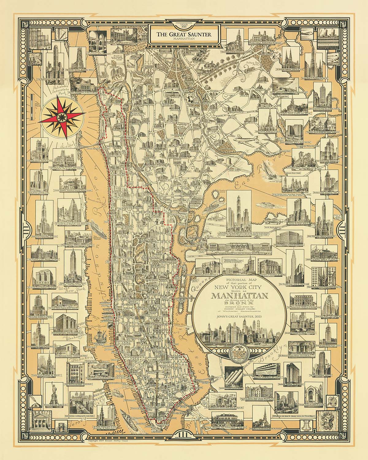
“Manhattan: The Great Saunter” is a striking city map that elegantly captures the 32-mile shoreline of Manhattan, inviting viewers to trace the...
Continue reading“Manhattan: The Great Saunter” is a striking city map that elegantly captures the 32-mile shoreline of Manhattan, inviting viewers to trace the legendary Great Saunter route in exquisite detail. The map’s original title, a nod to both the iconic island and the celebrated urban hike, immediately signals its dual nature as both a historical artifact and a living tribute to New York’s ever-evolving waterfront. The artistry of the map is rooted in the masterful 1939 base by Ernest Dudley Chase, whose pictorial flair and meticulous attention to detail are unmistakable, while the contemporary overlays from The Unique Maps Co. (2025) infuse it with new life, chronicling the city’s ongoing transformation.
This map is a love letter to Manhattan’s neighborhoods, each rendered with care and clarity. From the leafy expanse of Inwood at the island’s northern tip to the bustling streets of the Financial District at its southern edge, the map invites exploration of storied enclaves like Harlem, Washington Heights, Greenwich Village, SoHo, and Tribeca. The careful delineation of these neighborhoods, interwoven with the route of the Great Saunter, offers a rare, panoramic perspective of Manhattan’s diverse communities and their relationship to the waterfront—a relationship shaped by centuries of commerce, culture, and urban renewal.
The map’s pictorial style brings Manhattan’s world-famous landmarks vividly to life. The Statue of Liberty and Ellis Island stand sentinel off the southern tip, while the Empire State Building, Chrysler Building, and One World Trade Center rise majestically above the cityscape. Grant’s Tomb, The Cloisters, and the whimsical Little Red Lighthouse are rendered with the kind of detail that invites close study and admiration. Each illustration is not merely decorative but a reminder of the city’s layered history, its architectural triumphs, and the indelible mark these sites have left on the collective imagination.
Water is a central character in this cartographic narrative. The map’s elegant depiction of the Hudson, Harlem, and East Rivers frames Manhattan as both an island and a crossroads, shaped by the ebb and flow of tides and time. The Great Saunter route, hugging the shoreline, draws attention to the city’s revitalized waterfront parks—Central Park, Riverside Park, Fort Tryon Park, East River Park, Battery Park, and many more. These green spaces, once neglected or inaccessible, now form a nearly contiguous ribbon of public land, testament to decades of advocacy and the city’s enduring commitment to public life.
Ernest Dudley Chase, the map’s original creator, was renowned for his pictorial maps that blended accuracy with artistry, making each work a feast for the eyes and the intellect. His legacy is honored and extended by The Unique Maps Co., whose 2025 embellishments highlight the ongoing story of Manhattan’s waterfront and the communal spirit of the Great Saunter. This map is more than a navigational aid; it is a celebration of New York’s resilience, diversity, and boundless capacity for reinvention—qualities that make it an essential addition to any collection of historic city maps.
Streets and roads on this map
- 1st Avenue
- 2nd Avenue
- 3rd Avenue
- 5th Avenue
- 6th Avenue
- 7th Avenue
- 8th Avenue
- 9th Avenue
- 10th Avenue
- 11th Avenue
- 12th Avenue
- Amsterdam Avenue
- Avenue A
- Avenue B
- Avenue C
- Avenue D
- Broadway
- Central Park West
- Columbus Avenue
- Edgecombe Avenue
- Fort Washington Avenue
- Lenox Avenue
- Lexington Avenue
- Madison Avenue
- Park Avenue
- Riverside Drive
- St. Nicholas Avenue
- St. Nicholas Terrace
- West End Avenue
- York Avenue
Notable Features & Landmarks
- The Great Saunter route clearly marked, encircling the shoreline of Manhattan
- Central Park
- Riverside Park
- Fort Tryon Park
- Inwood Hill Park
- East River Park
- Battery Park
- Carl Schurz Park
- Hudson River Park
- Harlem River Park
- Morningside Park
- St. Nicholas Park
- Waterfront promenades and piers
- The Statue of Liberty (illustrated, off the southern tip)
- Ellis Island (illustrated, off the southern tip)
- The United Nations Headquarters (illustrated)
- The Empire State Building (illustrated)
- The Chrysler Building (illustrated)
- One World Trade Center (illustrated)
- Grant’s Tomb (illustrated)
- The Little Red Lighthouse (illustrated)
- The Cloisters (illustrated)
- Harlem
- Washington Heights
- Inwood
- Upper West Side
- Upper East Side
- Midtown
- Lower East Side
- Battery Park City
- Tribeca
- Greenwich Village
- Chelsea
- SoHo
- Chinatown
- Financial District
- Hudson River
- Harlem River
- East River
- George Washington Bridge
- Brooklyn Bridge
- Manhattan Bridge
- Williamsburg Bridge
- Queensboro (59th Street) Bridge
- Triborough (RFK) Bridge
- Henry Hudson Bridge
- Washington Bridge
- Decorative compass rose
- Vignettes of walking figures and Saunter participants
- Decorative title cartouche
Historical and design context
- Name of the map: Manhattan: The Great Saunter
- Depicts The Great Saunter, a 32-mile hiking route around Manhattan’s shoreline
- Mapmaker/publisher: The Unique Maps Co., 2025
- Base map originally created by Ernest Dudley Chase in 1939, a renowned mapmaker known for his pictorial style
- Updated in 2025 with the Great Saunter route and modern artistic flourishes
- City thematic and pictorial map, blending vintage and contemporary elements
- Focuses on urban hiking, public waterfront access, and interconnected parks and promenades
- Celebrates the annual Great Saunter event, recognized by the New York City Council as The Great Saunter Day
- Highlights the transformation of Manhattan’s waterfront, shaped by advocacy since 1982 for public access
- Combines historical cartography with modern urban culture and environmentalism
Please double check the images to make sure that a specific town or place is shown on this map. You can also get in touch and ask us to check the map for you.
This map looks great at every size, but I always recommend going for a larger size if you have space. That way you can easily make out all of the details.
This map looks amazing at sizes all the way up to 90in (230cm). If you are looking for a larger map, please get in touch.
The model in the listing images is holding the 16x20in (40x50cm) version of this map.
The fifth listing image shows an example of my map personalisation service.
If you’re looking for something slightly different, check out my collection of the best old maps to see if something else catches your eye.
Please contact me to check if a certain location, landmark or feature is shown on this map.
This would make a wonderful birthday, Christmas, Father's Day, work leaving, anniversary or housewarming gift for someone from the areas covered by this map.
This map is available as a giclée print on acid free archival matte paper, or you can buy it framed. The frame is a nice, simple black frame that suits most aesthetics. Please get in touch if you'd like a different frame colour or material. My frames are glazed with super-clear museum-grade acrylic (perspex/acrylite), which is significantly less reflective than glass, safer, and will always arrive in perfect condition.
This map is also available as a float framed canvas, sometimes known as a shadow gap framed canvas or canvas floater. The map is printed on artist's cotton canvas and then stretched over a handmade box frame. We then "float" the canvas inside a wooden frame, which is available in a range of colours (black, dark brown, oak, antique gold and white). This is a wonderful way to present a map without glazing in front. See some examples of float framed canvas maps and explore the differences between my different finishes.
For something truly unique, this map is also available in "Unique 3D", our trademarked process that dramatically transforms the map so that it has a wonderful sense of depth. We combine the original map with detailed topography and elevation data, so that mountains and the terrain really "pop". For more info and examples of 3D maps, check my Unique 3D page.
“Manhattan: The Great Saunter” is a striking city map that elegantly captures the 32-mile shoreline of Manhattan, inviting viewers to trace the legendary Great Saunter route in exquisite detail. The map’s original title, a nod to both the iconic island and the celebrated urban hike, immediately signals its dual nature as both a historical artifact and a living tribute to New York’s ever-evolving waterfront. The artistry of the map is rooted in the masterful 1939 base by Ernest Dudley Chase, whose pictorial flair and meticulous attention to detail are unmistakable, while the contemporary overlays from The Unique Maps Co. (2025) infuse it with new life, chronicling the city’s ongoing transformation.
This map is a love letter to Manhattan’s neighborhoods, each rendered with care and clarity. From the leafy expanse of Inwood at the island’s northern tip to the bustling streets of the Financial District at its southern edge, the map invites exploration of storied enclaves like Harlem, Washington Heights, Greenwich Village, SoHo, and Tribeca. The careful delineation of these neighborhoods, interwoven with the route of the Great Saunter, offers a rare, panoramic perspective of Manhattan’s diverse communities and their relationship to the waterfront—a relationship shaped by centuries of commerce, culture, and urban renewal.
The map’s pictorial style brings Manhattan’s world-famous landmarks vividly to life. The Statue of Liberty and Ellis Island stand sentinel off the southern tip, while the Empire State Building, Chrysler Building, and One World Trade Center rise majestically above the cityscape. Grant’s Tomb, The Cloisters, and the whimsical Little Red Lighthouse are rendered with the kind of detail that invites close study and admiration. Each illustration is not merely decorative but a reminder of the city’s layered history, its architectural triumphs, and the indelible mark these sites have left on the collective imagination.
Water is a central character in this cartographic narrative. The map’s elegant depiction of the Hudson, Harlem, and East Rivers frames Manhattan as both an island and a crossroads, shaped by the ebb and flow of tides and time. The Great Saunter route, hugging the shoreline, draws attention to the city’s revitalized waterfront parks—Central Park, Riverside Park, Fort Tryon Park, East River Park, Battery Park, and many more. These green spaces, once neglected or inaccessible, now form a nearly contiguous ribbon of public land, testament to decades of advocacy and the city’s enduring commitment to public life.
Ernest Dudley Chase, the map’s original creator, was renowned for his pictorial maps that blended accuracy with artistry, making each work a feast for the eyes and the intellect. His legacy is honored and extended by The Unique Maps Co., whose 2025 embellishments highlight the ongoing story of Manhattan’s waterfront and the communal spirit of the Great Saunter. This map is more than a navigational aid; it is a celebration of New York’s resilience, diversity, and boundless capacity for reinvention—qualities that make it an essential addition to any collection of historic city maps.
Streets and roads on this map
- 1st Avenue
- 2nd Avenue
- 3rd Avenue
- 5th Avenue
- 6th Avenue
- 7th Avenue
- 8th Avenue
- 9th Avenue
- 10th Avenue
- 11th Avenue
- 12th Avenue
- Amsterdam Avenue
- Avenue A
- Avenue B
- Avenue C
- Avenue D
- Broadway
- Central Park West
- Columbus Avenue
- Edgecombe Avenue
- Fort Washington Avenue
- Lenox Avenue
- Lexington Avenue
- Madison Avenue
- Park Avenue
- Riverside Drive
- St. Nicholas Avenue
- St. Nicholas Terrace
- West End Avenue
- York Avenue
Notable Features & Landmarks
- The Great Saunter route clearly marked, encircling the shoreline of Manhattan
- Central Park
- Riverside Park
- Fort Tryon Park
- Inwood Hill Park
- East River Park
- Battery Park
- Carl Schurz Park
- Hudson River Park
- Harlem River Park
- Morningside Park
- St. Nicholas Park
- Waterfront promenades and piers
- The Statue of Liberty (illustrated, off the southern tip)
- Ellis Island (illustrated, off the southern tip)
- The United Nations Headquarters (illustrated)
- The Empire State Building (illustrated)
- The Chrysler Building (illustrated)
- One World Trade Center (illustrated)
- Grant’s Tomb (illustrated)
- The Little Red Lighthouse (illustrated)
- The Cloisters (illustrated)
- Harlem
- Washington Heights
- Inwood
- Upper West Side
- Upper East Side
- Midtown
- Lower East Side
- Battery Park City
- Tribeca
- Greenwich Village
- Chelsea
- SoHo
- Chinatown
- Financial District
- Hudson River
- Harlem River
- East River
- George Washington Bridge
- Brooklyn Bridge
- Manhattan Bridge
- Williamsburg Bridge
- Queensboro (59th Street) Bridge
- Triborough (RFK) Bridge
- Henry Hudson Bridge
- Washington Bridge
- Decorative compass rose
- Vignettes of walking figures and Saunter participants
- Decorative title cartouche
Historical and design context
- Name of the map: Manhattan: The Great Saunter
- Depicts The Great Saunter, a 32-mile hiking route around Manhattan’s shoreline
- Mapmaker/publisher: The Unique Maps Co., 2025
- Base map originally created by Ernest Dudley Chase in 1939, a renowned mapmaker known for his pictorial style
- Updated in 2025 with the Great Saunter route and modern artistic flourishes
- City thematic and pictorial map, blending vintage and contemporary elements
- Focuses on urban hiking, public waterfront access, and interconnected parks and promenades
- Celebrates the annual Great Saunter event, recognized by the New York City Council as The Great Saunter Day
- Highlights the transformation of Manhattan’s waterfront, shaped by advocacy since 1982 for public access
- Combines historical cartography with modern urban culture and environmentalism
Please double check the images to make sure that a specific town or place is shown on this map. You can also get in touch and ask us to check the map for you.
This map looks great at every size, but I always recommend going for a larger size if you have space. That way you can easily make out all of the details.
This map looks amazing at sizes all the way up to 90in (230cm). If you are looking for a larger map, please get in touch.
The model in the listing images is holding the 16x20in (40x50cm) version of this map.
The fifth listing image shows an example of my map personalisation service.
If you’re looking for something slightly different, check out my collection of the best old maps to see if something else catches your eye.
Please contact me to check if a certain location, landmark or feature is shown on this map.
This would make a wonderful birthday, Christmas, Father's Day, work leaving, anniversary or housewarming gift for someone from the areas covered by this map.
This map is available as a giclée print on acid free archival matte paper, or you can buy it framed. The frame is a nice, simple black frame that suits most aesthetics. Please get in touch if you'd like a different frame colour or material. My frames are glazed with super-clear museum-grade acrylic (perspex/acrylite), which is significantly less reflective than glass, safer, and will always arrive in perfect condition.
This map is also available as a float framed canvas, sometimes known as a shadow gap framed canvas or canvas floater. The map is printed on artist's cotton canvas and then stretched over a handmade box frame. We then "float" the canvas inside a wooden frame, which is available in a range of colours (black, dark brown, oak, antique gold and white). This is a wonderful way to present a map without glazing in front. See some examples of float framed canvas maps and explore the differences between my different finishes.
For something truly unique, this map is also available in "Unique 3D", our trademarked process that dramatically transforms the map so that it has a wonderful sense of depth. We combine the original map with detailed topography and elevation data, so that mountains and the terrain really "pop". For more info and examples of 3D maps, check my Unique 3D page.
Many of our maps and art prints are chosen as thoughtful gifts for homes, offices, studies and meaningful places.
Choose a framed option for the easiest ready-to-hang gift, or choose an unframed print if the recipient may prefer to select their own frame.
We make orders locally in 23 countries around the world, so gifts can often be produced close to the recipient. This helps them arrive faster, travel more safely, and avoid customs or import duty surprises.
- We can deliver directly to the recipient
- Framed pieces arrive ready to hang
- Unframed prints are carefully packed in a strong protective tube
- Almost every order is made locally, for faster, safer gifting
- 90-day returns give the recipient time to decide
If you are not sure what to choose, please contact us. We can help you pick the right map, size, finish or delivery option.
Most orders are made locally and delivered in around 2–3 working days, depending on the product, size and destination.
We print and frame maps and artwork in 23 countries around the world, so your order is usually made close to you or your recipient. That means faster delivery, less time in transit, and no customs or import duty surprises.
Personalised and customised pieces usually take an extra 1–2 working days, because we prepare your design and send it to you for approval before printing.
Very large framed orders can take a little longer, as they need extra care in production and delivery.
Every order is carefully packaged: unframed prints are sent in a strong protective tube, while framed pieces are securely packed with protective materials around the frame.
If you need your order by a particular date, please contact us before ordering. We’ll check the best production route and delivery option for your location.
Express delivery is available at checkout for most countries. Next-day delivery is available in the UK, US, Singapore and the UAE.
Your order is covered by our 90-day returns policy and 10-year guarantee.
Our standard frame is a gallery-style black ash hardwood frame, with a simple, modern look. It is approximately 20mm (0.8in) wide. You can also view some lovely customer photos of framed maps and art.
We use super-clear acrylic glazing, also known as Perspex or Acrylite, instead of traditional glass. It is lighter, safer, and has lower reflectivity, giving the artwork a clearer, cleaner appearance.
Six standard frame colours are available at no extra cost: black, dark brown, dark grey, oak, white, and antique gold. Custom framing and mounting/matting is also available for customers looking for something more specific.
Most maps, art prints, and illustrations are also available as a framed canvas. We use matte cotton canvas, stretch it over a sustainably sourced wooden box frame, and then float the piece within a wooden outer frame. The finished result is beautifully presented, with no glazing between you and the artwork.
All frames are supplied ready to hang, with either string or brackets fitted to the back. Very large frames will include heavy-duty hanging plates and/or a mounting baton. If you have any questions, please get in touch.
We can also supply old maps and artwork on canvas, foam board, cotton rag, and other materials.
If you would prefer to frame your map or artwork yourself, please read our size guide before ordering.
My maps are extremely high quality reproductions of original maps.
I source original, rare maps from libraries, auction houses and private collections around the world, restore them at my London workshop, and then use specialist giclée inks and printers to create beautiful maps that look even better than the original.
My maps are printed on acid-free archival matte (not glossy) paper that feels very high quality and almost like card. In technical terms the paper weight/thickness is 10mil/200gsm. It's perfect for framing.
I print with Epson ultrachrome giclée UV fade resistant pigment inks - some of the best inks you can find.
I can also make maps on canvas, cotton rag and other exotic materials.
Learn more about The Unique Maps Co.
Map personalisation
If you're looking for the perfect anniversary or housewarming gift, I can personalise your map to make it truly unique. For example, I can add a short message, or highlight an important location, or add your family's coat of arms.
The options are almost infinite. Please see my map personalisation page for some wonderful examples of what's possible.
To order a personalised map, select "personalise your map" before adding it to your basket.
Get in touch if you're looking for more complex customisations and personalisations.
Map ageing
I have been asked hundreds of times over the years by customers if they could buy a map that looks even older.
Well, now you can, by selecting Aged before you add a map to your basket.
All the product photos you see on this page show the map in its Original form. This is what the map looks like today.
If you select Aged, I will age your map by hand, using a special and unique process developed through years of studying old maps, talking to researchers to understand the chemistry of aging paper, and of course... lots of practice!
If you're unsure, stick to the Original colour of the map. If you want something a bit darker and older looking, go for Aged.
If you are not happy with your order for any reason, contact me and I'll get it fixed ASAP, free of charge. Please see my returns and refund policy for more information.
I am very confident you will like your restored map or art print. I have been doing this since 1984. I'm a 5-star Etsy seller. I have sold tens of thousands of maps and art prints and have over 5,000 real 5-star reviews. My work has been featured in interior design magazines, on the BBC, and on the walls of dozens of 5-star hotels.
I use a unique process to restore maps and artwork that is massively time consuming and labour intensive. Hunting down the original maps and illustrations can take months. I use state of the art and eye-wateringly expensive technology to scan and restore them. As a result, I guarantee my maps and art prints are a cut above the rest. I stand by my products and will always make sure you're 100% happy with what you receive.
Almost all of my maps and art prints look amazing at large sizes (200cm, 6.5ft+) and I can frame and deliver them to you as well, via special oversized courier. Contact me to discuss your specific needs.
Or try searching for something!


