


Rare Old Cunard Caronia Coronation Cruise Map, 1953: London, Paris, Rome, Gibraltar, Athens
The Collector’s Offer
Choose two eligible works and receive 20% off both. Choose three and the lowest-priced one is complimentary, a maximum saving of 33%.
Mix and match eligible standard maps and fine-art prints. No code is required; the offer is applied automatically at checkout.
Standard made-to-order configurations are included. Bespoke sizes, personalised designs and commissioned work are excluded.
Need delivery to different addresses? Contact us before ordering.The Collector’s Offer
Choose two eligible works and receive 20% off both. Choose three and the lowest-priced one is complimentary, a maximum saving of 33%.
Mix and match eligible standard maps and fine-art prints. No code is required; the offer is applied automatically at checkout.
Standard made-to-order configurations are included. Bespoke sizes, personalised designs and commissioned work are excluded.
Need delivery to different addresses? Contact us before ordering. Restored in London • Made in Australia

Restored from the original 1953 map and printed to museum-grade archival standards. Read the story behind this map
Choose your size
Choose your finish


(More info)
Gift message & custom finish

If you want to add a gift message, or a finish (jigsaw, aluminium board, etc.) that is not available here, please request it in the "order note" when you check out.
Every order is custom made, so if you need the size adjusted slightly, or printed on an unusual material, just let us know. We've done thousands of custom orders over the years, so there's (almost) nothing we can't manage.
You can also contact us before you order, if you prefer!

- Made locally for fast, safe delivery
- No import duty or hidden fees
- Need advice? Call us or message on WhatsApp
Own a piece of history
8,000+ five-star reviews


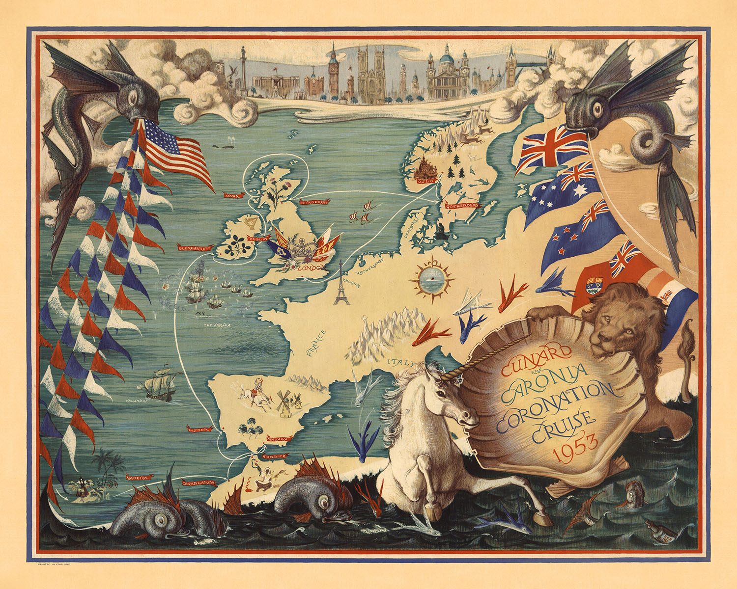
Step back in time with the exquisite Cunard Caronia Coronation Cruise map from 1953, a vivid and historically rich depiction of a...
Continue readingStep back in time with the exquisite Cunard Caronia Coronation Cruise map from 1953, a vivid and historically rich depiction of a grand maritime journey. Created by the talented DEB, this full-color map captures the essence of the 1953 Coronation Cruise, celebrating the coronation of Queen Elizabeth II. The map's vibrant colors and intricate illustrations bring to life the significant routes, destinations, and landmarks associated with this historic event, making it a captivating piece for collectors and history enthusiasts alike.
The map beautifully illustrates the journey of the Cunard Caronia, highlighting key locations such as London, Dover, and Edinburgh in the United Kingdom, as well as Paris, Rome, and Gibraltar in Europe. Each city and landmark is meticulously depicted, showcasing the cultural and historical significance of the cruise's itinerary. The inclusion of flags from various countries emphasizes the international nature of the voyage, reflecting the global celebration of the coronation.
One of the most striking features of this map is its artistic style, which combines thematic and pictorial elements to create a visually stunning representation of the cruise. The detailed illustrations of the ship, marine life, and mythical creatures add a whimsical touch, while the use of heraldic symbols and emblems denotes the regal significance of the event. The map's elaborate border and decorative elements further enhance its aesthetic appeal, making it a true work of art.
Historically, this map holds great significance as it commemorates a pivotal moment in British history—the coronation of Queen Elizabeth II. The map not only serves as a record of the cruise but also as a reflection of the cultural and historical context of the early 1950s. The depiction of iconic landmarks such as the Eiffel Tower and the inclusion of historical and mythical figures add layers of storytelling, providing a rich narrative of the era.
For those with a passion for maritime history, royal events, or simply the allure of vintage maps, the Cunard Caronia Coronation Cruise map is a treasure trove of historical and artistic value. Its detailed portrayal of the cruise's journey, combined with its vibrant colors and intricate design, makes it an exceptional addition to any collection. This map is not just a visual delight but also a fascinating glimpse into a bygone era, celebrating a momentous occasion in the annals of history.
Places on this map
- London
- Dover
- Edinburgh
- Canterbury
- Paris
- Rome
- Gibraltar
- Naples
- Lisbon
- Southampton
- Venice
- Barcelona
- Malta
- Athens
- Istanbul
- Monaco
- Cannes
- Genoa
- Palermo
- Alexandria
Notable Features & Landmarks
- The route of the Cunard Caronia Coronation Cruise.
- The depiction of major cities and landmarks in the United Kingdom, such as London.
- Illustrations of key locations visited during the cruise.
- Artistic representations of the sea and marine life.
- Flags of various countries, indicating the international nature of the cruise.
- The presence of mythical creatures and symbolic figures, enhancing the thematic elements.
- The detailed illustration of the ship Cunard Caronia.
- The depiction of the coronation event, symbolized by regal imagery.
- The inclusion of significant historical landmarks, such as the Eiffel Tower in France.
- The artistic border framing the map, adding to its aesthetic appeal.
- The representation of different weather conditions and natural elements.
- The inclusion of cultural symbols and motifs relevant to the time period.
- The visual representation of the cruise's journey across different seas.
- The inclusion of iconic buildings and structures, such as cathedrals and castles.
- The artistic rendering of the coastline and geographical features.
- The use of heraldic symbols and emblems to denote significance.
- The portrayal of different cultural and historical elements relevant to the cruise.
- The detailed illustration of the ship's itinerary and stops.
- The artistic depiction of marine and nautical themes.
- The inclusion of significant historical events and their locations.
Historical and design context
- Name of the map: Cunard Caronia Coronation Cruise 1953
- When the map was made: 1953
- Mapmaker or publisher: DEB
- DEB is likely an artist or illustrator known for creating thematic and pictorial maps, emphasizing both aesthetic appeal and historical information.
- Topics and themes shown on the map:
- The map focuses on the 1953 Coronation Cruise of the Cunard Caronia.
- It highlights significant routes, destinations, and historical landmarks associated with the cruise.
- Design or style of the map:
- The map features a pictorial and thematic style, with elaborate illustrations and vibrant colors.
- It includes artistic representations of landmarks, symbols, and routes.
- Historical significance or context of the map:
- The map commemorates the 1953 Coronation Cruise, an event marking the coronation of Queen Elizabeth II.
- It reflects the cultural and historical context of the early 1950s, showcasing the maritime tradition and the significance of royal events.
Please double check the images to make sure that a specific town or place is shown on this map. You can also get in touch and ask us to check the map for you.
This map looks great at every size, but I always recommend going for a larger size if you have space. That way you can easily make out all of the details.
This map looks amazing at sizes all the way up to 90in (230cm). If you are looking for a larger map, please get in touch.
The model in the listing images is holding the 16x20in (40x50cm) version of this map.
The fifth listing image shows an example of my map personalisation service.
If you’re looking for something slightly different, check out my collection of the best old maps to see if something else catches your eye.
Please contact me to check if a certain location, landmark or feature is shown on this map.
This would make a wonderful birthday, Christmas, Father's Day, work leaving, anniversary or housewarming gift for someone from the areas covered by this map.
This map is available as a giclée print on acid free archival matte paper, or you can buy it framed. The frame is a nice, simple black frame that suits most aesthetics. Please get in touch if you'd like a different frame colour or material. My frames are glazed with super-clear museum-grade acrylic (perspex/acrylite), which is significantly less reflective than glass, safer, and will always arrive in perfect condition.
This map is also available as a float framed canvas, sometimes known as a shadow gap framed canvas or canvas floater. The map is printed on artist's cotton canvas and then stretched over a handmade box frame. We then "float" the canvas inside a wooden frame, which is available in a range of colours (black, dark brown, oak, antique gold and white). This is a wonderful way to present a map without glazing in front. See some examples of float framed canvas maps and explore the differences between my different finishes.
For something truly unique, this map is also available in "Unique 3D", our trademarked process that dramatically transforms the map so that it has a wonderful sense of depth. We combine the original map with detailed topography and elevation data, so that mountains and the terrain really "pop". For more info and examples of 3D maps, check my Unique 3D page.
Step back in time with the exquisite Cunard Caronia Coronation Cruise map from 1953, a vivid and historically rich depiction of a grand maritime journey. Created by the talented DEB, this full-color map captures the essence of the 1953 Coronation Cruise, celebrating the coronation of Queen Elizabeth II. The map's vibrant colors and intricate illustrations bring to life the significant routes, destinations, and landmarks associated with this historic event, making it a captivating piece for collectors and history enthusiasts alike.
The map beautifully illustrates the journey of the Cunard Caronia, highlighting key locations such as London, Dover, and Edinburgh in the United Kingdom, as well as Paris, Rome, and Gibraltar in Europe. Each city and landmark is meticulously depicted, showcasing the cultural and historical significance of the cruise's itinerary. The inclusion of flags from various countries emphasizes the international nature of the voyage, reflecting the global celebration of the coronation.
One of the most striking features of this map is its artistic style, which combines thematic and pictorial elements to create a visually stunning representation of the cruise. The detailed illustrations of the ship, marine life, and mythical creatures add a whimsical touch, while the use of heraldic symbols and emblems denotes the regal significance of the event. The map's elaborate border and decorative elements further enhance its aesthetic appeal, making it a true work of art.
Historically, this map holds great significance as it commemorates a pivotal moment in British history—the coronation of Queen Elizabeth II. The map not only serves as a record of the cruise but also as a reflection of the cultural and historical context of the early 1950s. The depiction of iconic landmarks such as the Eiffel Tower and the inclusion of historical and mythical figures add layers of storytelling, providing a rich narrative of the era.
For those with a passion for maritime history, royal events, or simply the allure of vintage maps, the Cunard Caronia Coronation Cruise map is a treasure trove of historical and artistic value. Its detailed portrayal of the cruise's journey, combined with its vibrant colors and intricate design, makes it an exceptional addition to any collection. This map is not just a visual delight but also a fascinating glimpse into a bygone era, celebrating a momentous occasion in the annals of history.
Places on this map
- London
- Dover
- Edinburgh
- Canterbury
- Paris
- Rome
- Gibraltar
- Naples
- Lisbon
- Southampton
- Venice
- Barcelona
- Malta
- Athens
- Istanbul
- Monaco
- Cannes
- Genoa
- Palermo
- Alexandria
Notable Features & Landmarks
- The route of the Cunard Caronia Coronation Cruise.
- The depiction of major cities and landmarks in the United Kingdom, such as London.
- Illustrations of key locations visited during the cruise.
- Artistic representations of the sea and marine life.
- Flags of various countries, indicating the international nature of the cruise.
- The presence of mythical creatures and symbolic figures, enhancing the thematic elements.
- The detailed illustration of the ship Cunard Caronia.
- The depiction of the coronation event, symbolized by regal imagery.
- The inclusion of significant historical landmarks, such as the Eiffel Tower in France.
- The artistic border framing the map, adding to its aesthetic appeal.
- The representation of different weather conditions and natural elements.
- The inclusion of cultural symbols and motifs relevant to the time period.
- The visual representation of the cruise's journey across different seas.
- The inclusion of iconic buildings and structures, such as cathedrals and castles.
- The artistic rendering of the coastline and geographical features.
- The use of heraldic symbols and emblems to denote significance.
- The portrayal of different cultural and historical elements relevant to the cruise.
- The detailed illustration of the ship's itinerary and stops.
- The artistic depiction of marine and nautical themes.
- The inclusion of significant historical events and their locations.
Historical and design context
- Name of the map: Cunard Caronia Coronation Cruise 1953
- When the map was made: 1953
- Mapmaker or publisher: DEB
- DEB is likely an artist or illustrator known for creating thematic and pictorial maps, emphasizing both aesthetic appeal and historical information.
- Topics and themes shown on the map:
- The map focuses on the 1953 Coronation Cruise of the Cunard Caronia.
- It highlights significant routes, destinations, and historical landmarks associated with the cruise.
- Design or style of the map:
- The map features a pictorial and thematic style, with elaborate illustrations and vibrant colors.
- It includes artistic representations of landmarks, symbols, and routes.
- Historical significance or context of the map:
- The map commemorates the 1953 Coronation Cruise, an event marking the coronation of Queen Elizabeth II.
- It reflects the cultural and historical context of the early 1950s, showcasing the maritime tradition and the significance of royal events.
Please double check the images to make sure that a specific town or place is shown on this map. You can also get in touch and ask us to check the map for you.
This map looks great at every size, but I always recommend going for a larger size if you have space. That way you can easily make out all of the details.
This map looks amazing at sizes all the way up to 90in (230cm). If you are looking for a larger map, please get in touch.
The model in the listing images is holding the 16x20in (40x50cm) version of this map.
The fifth listing image shows an example of my map personalisation service.
If you’re looking for something slightly different, check out my collection of the best old maps to see if something else catches your eye.
Please contact me to check if a certain location, landmark or feature is shown on this map.
This would make a wonderful birthday, Christmas, Father's Day, work leaving, anniversary or housewarming gift for someone from the areas covered by this map.
This map is available as a giclée print on acid free archival matte paper, or you can buy it framed. The frame is a nice, simple black frame that suits most aesthetics. Please get in touch if you'd like a different frame colour or material. My frames are glazed with super-clear museum-grade acrylic (perspex/acrylite), which is significantly less reflective than glass, safer, and will always arrive in perfect condition.
This map is also available as a float framed canvas, sometimes known as a shadow gap framed canvas or canvas floater. The map is printed on artist's cotton canvas and then stretched over a handmade box frame. We then "float" the canvas inside a wooden frame, which is available in a range of colours (black, dark brown, oak, antique gold and white). This is a wonderful way to present a map without glazing in front. See some examples of float framed canvas maps and explore the differences between my different finishes.
For something truly unique, this map is also available in "Unique 3D", our trademarked process that dramatically transforms the map so that it has a wonderful sense of depth. We combine the original map with detailed topography and elevation data, so that mountains and the terrain really "pop". For more info and examples of 3D maps, check my Unique 3D page.
Many of our maps and art prints are chosen as thoughtful gifts for homes, offices, studies and meaningful places.
Choose a framed option for the easiest ready-to-hang gift, or choose an unframed print if the recipient may prefer to select their own frame.
We make orders locally in 23 countries around the world, so gifts can often be produced close to the recipient. This helps them arrive faster, travel more safely, and avoid customs or import duty surprises.
- We can deliver directly to the recipient
- Framed pieces arrive ready to hang
- Unframed prints are carefully packed in a strong protective tube
- Almost every order is made locally, for faster, safer gifting
- 90-day returns give the recipient time to decide
If you are not sure what to choose, please contact us. We can help you pick the right map, size, finish or delivery option.
Most orders are made locally and delivered in around 2–3 working days, depending on the product, size and destination.
We print and frame maps and artwork in 23 countries around the world, so your order is usually made close to you or your recipient. That means faster delivery, less time in transit, and no customs or import duty surprises.
Personalised and customised pieces usually take an extra 1–2 working days, because we prepare your design and send it to you for approval before printing.
Very large framed orders can take a little longer, as they need extra care in production and delivery.
Every order is carefully packaged: unframed prints are sent in a strong protective tube, while framed pieces are securely packed with protective materials around the frame.
If you need your order by a particular date, please contact us before ordering. We’ll check the best production route and delivery option for your location.
Express delivery is available at checkout for most countries. Next-day delivery is available in the UK, US, Singapore and the UAE.
Your order is covered by our 90-day returns policy and 10-year guarantee.
Our standard frame is a gallery-style black ash hardwood frame, with a simple, modern look. It is approximately 20mm (0.8in) wide. You can also view some lovely customer photos of framed maps and art.
We use super-clear acrylic glazing, also known as Perspex or Acrylite, instead of traditional glass. It is lighter, safer, and has lower reflectivity, giving the artwork a clearer, cleaner appearance.
Six standard frame colours are available at no extra cost: black, dark brown, dark grey, oak, white, and antique gold. Custom framing and mounting/matting is also available for customers looking for something more specific.
Most maps, art prints, and illustrations are also available as a framed canvas. We use matte cotton canvas, stretch it over a sustainably sourced wooden box frame, and then float the piece within a wooden outer frame. The finished result is beautifully presented, with no glazing between you and the artwork.
All frames are supplied ready to hang, with either string or brackets fitted to the back. Very large frames will include heavy-duty hanging plates and/or a mounting baton. If you have any questions, please get in touch.
We can also supply old maps and artwork on canvas, foam board, cotton rag, and other materials.
If you would prefer to frame your map or artwork yourself, please read our size guide before ordering.
Every Unique Maps piece begins with an authentic cartographic source or an original design from our London studio.
For our historic maps, we source rare originals from libraries, archives, auction houses and private collections around the world. We carefully restore each map for print—repairing age-related damage, balancing colour and improving clarity while preserving its original detail, texture and character.
Once restored, the map is prepared for your chosen size and finish. Your piece is then printed and, where selected, framed close to its delivery destination.
Our map prints use acid-free 200gsm archival matte paper and fade-resistant pigment inks, creating a rich, non-glossy finish designed to last. Framed maps use crystal-clear optical acrylic and arrive ready to hang.
Canvas, cotton-rag and other specialist presentations are also available. Learn more about our materials and finishes.
Personalising your map
You can add a short title or dedication, mark one meaningful place, or request one considered visual detail. For personalised designs, we send a proof before printing and you can request changes before approval.
For more complex bespoke commissions, contact our design team.
Original or Aged
Choose Original for true-to-source colour, or Aged for a warmer, richer antique character created with our specialist ageing process. See examples of our Aged maps.
If you are not happy with your order for any reason, contact me and I'll get it fixed ASAP, free of charge. Please see my returns and refund policy for more information.
I am very confident you will like your restored map or art print. I have been doing this since 1984. I'm a 5-star Etsy seller. I have sold tens of thousands of maps and art prints and have over 5,000 real 5-star reviews. My work has been featured in interior design magazines, on the BBC, and on the walls of dozens of 5-star hotels.
I use a unique process to restore maps and artwork that is massively time consuming and labour intensive. Hunting down the original maps and illustrations can take months. I use state of the art and eye-wateringly expensive technology to scan and restore them. As a result, I guarantee my maps and art prints are a cut above the rest. I stand by my products and will always make sure you're 100% happy with what you receive.
Almost all of my maps and art prints look amazing at large sizes (200cm, 6.5ft+) and I can frame and deliver them to you as well, via special oversized courier. Contact me to discuss your specific needs.
Or try searching for something!


