


Rare Old Map of India's Railways by Nirdosh, 1960: Mumbai, Delhi, Kolkata, Chennai, Bangalore
The Collector’s Offer
Choose two eligible works and receive 20% off both. Choose three and the lowest-priced one is complimentary, a maximum saving of 33%.
Mix and match eligible standard maps and fine-art prints. No code is required; the offer is applied automatically at checkout.
Standard made-to-order configurations are included. Bespoke sizes, personalised designs and commissioned work are excluded.
Need delivery to different addresses? Contact us before ordering.The Collector’s Offer
Choose two eligible works and receive 20% off both. Choose three and the lowest-priced one is complimentary, a maximum saving of 33%.
Mix and match eligible standard maps and fine-art prints. No code is required; the offer is applied automatically at checkout.
Standard made-to-order configurations are included. Bespoke sizes, personalised designs and commissioned work are excluded.
Need delivery to different addresses? Contact us before ordering. Designed in London Made in Australia
Designed in London • Made in Australia
Designed in London Made in Australia
Designed in London • Made in Australia

Restored from the original 1960 map and printed to museum-grade archival standards. Read the story behind this map
Choose your size
Choose your finish


(More info)
Gift message & custom finish

If you want to add a gift message, or a finish (jigsaw, aluminium board, etc.) that is not available here, please request it in the "order note" when you check out.
Every order is custom made, so if you need the size adjusted slightly, or printed on an unusual material, just let us know. We've done thousands of custom orders over the years, so there's (almost) nothing we can't manage.
You can also contact us before you order, if you prefer!

- Made locally for fast, safe delivery
- No import duty or hidden fees
- Need advice? Call us or message on WhatsApp
Own a piece of history
8,000+ five-star reviews


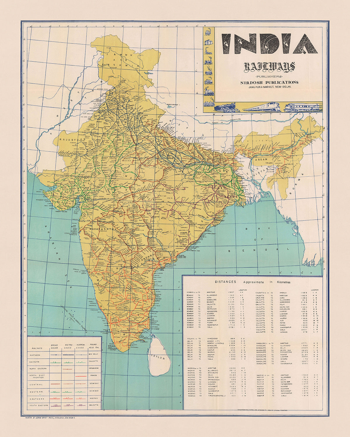
Presenting the "India Railways" map, an exquisite cartographic masterpiece created by Nirdosh Publications in 1960. This thematic map is a detailed portrayal...
Continue readingPresenting the "India Railways" map, an exquisite cartographic masterpiece created by Nirdosh Publications in 1960. This thematic map is a detailed portrayal of India's extensive railway network, meticulously differentiated by color and track gauge. Each railway line is vividly illustrated, showcasing the routes of the Eastern, Western, Southern, and Southeastern Railways. This map is not just a navigational tool but a historical document that captures the essence of India's post-independence transportation infrastructure, reflecting the nation's efforts to connect its diverse regions through a robust railway system.
Nirdosh Publications, the esteemed mapmaker behind this creation, has a legacy of producing high-quality cartographic works. Printed by the Gemini Offset Press in New Delhi, this map exemplifies the precision and artistry of mid-20th-century Indian cartography. The decorative title cartouche, adorned with vignettes of historical train engines, adds a touch of elegance and nostalgia, making it a perfect blend of functionality and aesthetic appeal. The map's design and execution are a testament to the skill and dedication of its creators, who aimed to provide a comprehensive and visually appealing representation of India's railways.
The map's detailed depiction of cities and towns along every railway line offers a fascinating glimpse into India's urban landscape during the 1960s. Major cities like Mumbai, Delhi, Kolkata, and Chennai are prominently featured, along with numerous smaller towns that played crucial roles in the country's economic and social fabric. The inclusion of a table providing distances between major cities in kilometers enhances the map's utility, making it an invaluable resource for travelers and historians alike. This feature underscores the map's practical significance, offering insights into the connectivity and accessibility of various regions.
Geographical features such as the Bay of Bengal and the Arabian Sea are labeled, providing context to the railway routes that traverse the subcontinent. The general representation of the Himalayas in the northern region adds a layer of geographical context, highlighting the challenges and triumphs of constructing railways in diverse terrains. The map's focus on railways, while omitting other political and geographical features, emphasizes the importance of rail transport in unifying the nation and facilitating trade, travel, and communication.
Historically, the "India Railways" map is a valuable artifact that reflects the state of India's railway network in the post-independence era. It captures a pivotal moment in the nation's history when railways were a symbol of progress and modernization. The map not only serves as a navigational aid but also as a historical document that offers insights into the development of India's transportation infrastructure. It stands as a testament to the vision and ambition of a nation striving to connect its people and regions through an intricate web of railways.
Cities and towns on this map
- India:
- Mumbai
- Delhi
- Kolkata
- Chennai
- Bangalore
- Hyderabad
- Ahmedabad
- Pune
- Surat
- Kanpur
- Jaipur
- Lucknow
- Nagpur
- Indore
- Bhopal
- Patna
- Vadodara
- Ghaziabad
- Ludhiana
- Agra
- Nashik
- Faridabad
- Meerut
- Rajkot
- Kalyan-Dombivli
- Vasai-Virar
- Varanasi
- Srinagar
- Aurangabad
- Dhanbad
- Amritsar
- Navi Mumbai
- Allahabad
- Ranchi
- Howrah
- Coimbatore
- Jabalpur
- Gwalior
- Vijayawada
- Jodhpur
- Madurai
- Raipur
- Kota
- Guwahati
- Chandigarh
- Solapur
- Hubballi-Dharwad
- Tiruchirappalli
- Bareilly
- Aligarh
- Tiruppur
- Moradabad
- Mysore
- Gurgaon
- Alwar
- Jalandhar
- Bhubaneswar
- Salem
- Mira-Bhayandar
- Thiruvananthapuram
- Bhiwandi
- Saharanpur
- Gorakhpur
- Guntur
- Bikaner
- Noida
- Jamshedpur
- Bhavnagar
- Cuttack
- Firozabad
- Kochi
- Bhilai
- Amravati
- Kolhapur
- Ulhasnagar
- Ajmer
- Gulbarga
- Jamnagar
- Ujjain
- Loni
- Siliguri
- Jhansi
- Uluberia
- Nellore
- Jammu
- Sangli-Miraj & Kupwad
- Belgaum
- Mangalore
- Ambattur
- Tirunelveli
- Malegaon
- Gaya
- Jalgaon
- Udaipur
- Maheshtala
- Durgapur
- Bellary
- Muzaffarnagar
- Kurnool
- Bharatpur
- Shahjahanpur
- Avadi
- Kadapa
- Nanded
- Panihati
- Sambalpur
- Bilaspur
- Shimoga
- Tumkur
- Karimnagar
- Gopalpur
- Dehradun
- Gandhinagar
- Thanjavur
- Katihar
- Dibrugarh
- Silchar
- Imphal
- Aizawl
- Kohima
- Itanagar
- Port Blair
Notable Features & Landmarks
- Inset maps:
- None visible.
- Illustrations:
- Vignettes of historical train engines in the upper right corner.
- Landmarks:
- None specifically labeled.
- Bodies of water:
- Bay of Bengal
- Arabian Sea
- Borders:
- International borders of India
- Border with Ceylon (modern-day Sri Lanka)
- Mountains:
- General representation of the Himalayas in the northern region.
- Other notable features:
- Table of distances between major cities in kilometers in the lower right.
- Key explaining railway notations in the lower left.
Historical and design context
- Name of the map: India Railways
- Extra notes:
- This is a c. 1960 railroad map of India.
- Depicts India's railroad network in detail.
- Eight different railways are differentiated by color and further divided by track gauge.
- Routes of the Eastern Railway, Western Railway, Southern Railway, and Southeastern Railway are labeled.
- Cities and towns are labeled along every line.
- A table providing distances between major cities in kilometers is located in the lower right.
- A key in the lower left explains notations used to differentiate railways and broad-, meter-, and narrow-gauge lines.
- A decorative title cartouche appears in the upper right bordered by vignettes of historical train engines.
- When the map was made: 1960
- Mapmaker or publisher: Nirdosh Publications
- Printed by the Gemini Offset Press in New Delhi.
- Topics and themes shown on the map:
- Primarily a railway map.
- Differentiates between broad-, meter-, and narrow-gauge lines.
- Highlights the extensive railroad network in India during the 1960s.
- Countries and regions shown on the map: India, with a portion of Ceylon (modern-day Sri Lanka).
- Design or style of the map:
- Thematic map focusing on railroads.
- Uses color coding to differentiate between various railways and track gauges.
- Includes decorative elements such as vignettes of historical train engines.
- Historical significance or context:
- Reflects the state of India's railway network in the post-independence era.
- Illustrates the importance of railways in connecting various parts of India.
- Provides historical insight into transportation and infrastructure development during the 1960s.
Please double check the images to make sure that a specific town or place is shown on this map. You can also get in touch and ask us to check the map for you.
This map looks great at every size, but I always recommend going for a larger size if you have space. That way you can easily make out all of the details.
This map looks amazing at sizes all the way up to 50in (125cm). If you are looking for a larger map, please get in touch.
Please note: the labels on this map are hard to read if you order a map that is 16in (40cm) or smaller. The map is still very attractive, but if you would like to read the map easily, please buy a larger size.
The model in the listing images is holding the 16x20in (40x50cm) version of this map.
The fifth listing image shows an example of my map personalisation service.
If you’re looking for something slightly different, check out my collection of the best old maps to see if something else catches your eye.
Please contact me to check if a certain location, landmark or feature is shown on this map.
This would make a wonderful birthday, Christmas, Father's Day, work leaving, anniversary or housewarming gift for someone from the areas covered by this map.
This map is available as a giclée print on acid free archival matte paper, or you can buy it framed. The frame is a nice, simple black frame that suits most aesthetics. Please get in touch if you'd like a different frame colour or material. My frames are glazed with super-clear museum-grade acrylic (perspex/acrylite), which is significantly less reflective than glass, safer, and will always arrive in perfect condition.
This map is also available as a float framed canvas, sometimes known as a shadow gap framed canvas or canvas floater. The map is printed on artist's cotton canvas and then stretched over a handmade box frame. We then "float" the canvas inside a wooden frame, which is available in a range of colours (black, dark brown, oak, antique gold and white). This is a wonderful way to present a map without glazing in front. See some examples of float framed canvas maps and explore the differences between my different finishes.
For something truly unique, this map is also available in "Unique 3D", our trademarked process that dramatically transforms the map so that it has a wonderful sense of depth. We combine the original map with detailed topography and elevation data, so that mountains and the terrain really "pop". For more info and examples of 3D maps, check my Unique 3D page.
Presenting the "India Railways" map, an exquisite cartographic masterpiece created by Nirdosh Publications in 1960. This thematic map is a detailed portrayal of India's extensive railway network, meticulously differentiated by color and track gauge. Each railway line is vividly illustrated, showcasing the routes of the Eastern, Western, Southern, and Southeastern Railways. This map is not just a navigational tool but a historical document that captures the essence of India's post-independence transportation infrastructure, reflecting the nation's efforts to connect its diverse regions through a robust railway system.
Nirdosh Publications, the esteemed mapmaker behind this creation, has a legacy of producing high-quality cartographic works. Printed by the Gemini Offset Press in New Delhi, this map exemplifies the precision and artistry of mid-20th-century Indian cartography. The decorative title cartouche, adorned with vignettes of historical train engines, adds a touch of elegance and nostalgia, making it a perfect blend of functionality and aesthetic appeal. The map's design and execution are a testament to the skill and dedication of its creators, who aimed to provide a comprehensive and visually appealing representation of India's railways.
The map's detailed depiction of cities and towns along every railway line offers a fascinating glimpse into India's urban landscape during the 1960s. Major cities like Mumbai, Delhi, Kolkata, and Chennai are prominently featured, along with numerous smaller towns that played crucial roles in the country's economic and social fabric. The inclusion of a table providing distances between major cities in kilometers enhances the map's utility, making it an invaluable resource for travelers and historians alike. This feature underscores the map's practical significance, offering insights into the connectivity and accessibility of various regions.
Geographical features such as the Bay of Bengal and the Arabian Sea are labeled, providing context to the railway routes that traverse the subcontinent. The general representation of the Himalayas in the northern region adds a layer of geographical context, highlighting the challenges and triumphs of constructing railways in diverse terrains. The map's focus on railways, while omitting other political and geographical features, emphasizes the importance of rail transport in unifying the nation and facilitating trade, travel, and communication.
Historically, the "India Railways" map is a valuable artifact that reflects the state of India's railway network in the post-independence era. It captures a pivotal moment in the nation's history when railways were a symbol of progress and modernization. The map not only serves as a navigational aid but also as a historical document that offers insights into the development of India's transportation infrastructure. It stands as a testament to the vision and ambition of a nation striving to connect its people and regions through an intricate web of railways.
Cities and towns on this map
- India:
- Mumbai
- Delhi
- Kolkata
- Chennai
- Bangalore
- Hyderabad
- Ahmedabad
- Pune
- Surat
- Kanpur
- Jaipur
- Lucknow
- Nagpur
- Indore
- Bhopal
- Patna
- Vadodara
- Ghaziabad
- Ludhiana
- Agra
- Nashik
- Faridabad
- Meerut
- Rajkot
- Kalyan-Dombivli
- Vasai-Virar
- Varanasi
- Srinagar
- Aurangabad
- Dhanbad
- Amritsar
- Navi Mumbai
- Allahabad
- Ranchi
- Howrah
- Coimbatore
- Jabalpur
- Gwalior
- Vijayawada
- Jodhpur
- Madurai
- Raipur
- Kota
- Guwahati
- Chandigarh
- Solapur
- Hubballi-Dharwad
- Tiruchirappalli
- Bareilly
- Aligarh
- Tiruppur
- Moradabad
- Mysore
- Gurgaon
- Alwar
- Jalandhar
- Bhubaneswar
- Salem
- Mira-Bhayandar
- Thiruvananthapuram
- Bhiwandi
- Saharanpur
- Gorakhpur
- Guntur
- Bikaner
- Noida
- Jamshedpur
- Bhavnagar
- Cuttack
- Firozabad
- Kochi
- Bhilai
- Amravati
- Kolhapur
- Ulhasnagar
- Ajmer
- Gulbarga
- Jamnagar
- Ujjain
- Loni
- Siliguri
- Jhansi
- Uluberia
- Nellore
- Jammu
- Sangli-Miraj & Kupwad
- Belgaum
- Mangalore
- Ambattur
- Tirunelveli
- Malegaon
- Gaya
- Jalgaon
- Udaipur
- Maheshtala
- Durgapur
- Bellary
- Muzaffarnagar
- Kurnool
- Bharatpur
- Shahjahanpur
- Avadi
- Kadapa
- Nanded
- Panihati
- Sambalpur
- Bilaspur
- Shimoga
- Tumkur
- Karimnagar
- Gopalpur
- Dehradun
- Gandhinagar
- Thanjavur
- Katihar
- Dibrugarh
- Silchar
- Imphal
- Aizawl
- Kohima
- Itanagar
- Port Blair
Notable Features & Landmarks
- Inset maps:
- None visible.
- Illustrations:
- Vignettes of historical train engines in the upper right corner.
- Landmarks:
- None specifically labeled.
- Bodies of water:
- Bay of Bengal
- Arabian Sea
- Borders:
- International borders of India
- Border with Ceylon (modern-day Sri Lanka)
- Mountains:
- General representation of the Himalayas in the northern region.
- Other notable features:
- Table of distances between major cities in kilometers in the lower right.
- Key explaining railway notations in the lower left.
Historical and design context
- Name of the map: India Railways
- Extra notes:
- This is a c. 1960 railroad map of India.
- Depicts India's railroad network in detail.
- Eight different railways are differentiated by color and further divided by track gauge.
- Routes of the Eastern Railway, Western Railway, Southern Railway, and Southeastern Railway are labeled.
- Cities and towns are labeled along every line.
- A table providing distances between major cities in kilometers is located in the lower right.
- A key in the lower left explains notations used to differentiate railways and broad-, meter-, and narrow-gauge lines.
- A decorative title cartouche appears in the upper right bordered by vignettes of historical train engines.
- When the map was made: 1960
- Mapmaker or publisher: Nirdosh Publications
- Printed by the Gemini Offset Press in New Delhi.
- Topics and themes shown on the map:
- Primarily a railway map.
- Differentiates between broad-, meter-, and narrow-gauge lines.
- Highlights the extensive railroad network in India during the 1960s.
- Countries and regions shown on the map: India, with a portion of Ceylon (modern-day Sri Lanka).
- Design or style of the map:
- Thematic map focusing on railroads.
- Uses color coding to differentiate between various railways and track gauges.
- Includes decorative elements such as vignettes of historical train engines.
- Historical significance or context:
- Reflects the state of India's railway network in the post-independence era.
- Illustrates the importance of railways in connecting various parts of India.
- Provides historical insight into transportation and infrastructure development during the 1960s.
Please double check the images to make sure that a specific town or place is shown on this map. You can also get in touch and ask us to check the map for you.
This map looks great at every size, but I always recommend going for a larger size if you have space. That way you can easily make out all of the details.
This map looks amazing at sizes all the way up to 50in (125cm). If you are looking for a larger map, please get in touch.
Please note: the labels on this map are hard to read if you order a map that is 16in (40cm) or smaller. The map is still very attractive, but if you would like to read the map easily, please buy a larger size.
The model in the listing images is holding the 16x20in (40x50cm) version of this map.
The fifth listing image shows an example of my map personalisation service.
If you’re looking for something slightly different, check out my collection of the best old maps to see if something else catches your eye.
Please contact me to check if a certain location, landmark or feature is shown on this map.
This would make a wonderful birthday, Christmas, Father's Day, work leaving, anniversary or housewarming gift for someone from the areas covered by this map.
This map is available as a giclée print on acid free archival matte paper, or you can buy it framed. The frame is a nice, simple black frame that suits most aesthetics. Please get in touch if you'd like a different frame colour or material. My frames are glazed with super-clear museum-grade acrylic (perspex/acrylite), which is significantly less reflective than glass, safer, and will always arrive in perfect condition.
This map is also available as a float framed canvas, sometimes known as a shadow gap framed canvas or canvas floater. The map is printed on artist's cotton canvas and then stretched over a handmade box frame. We then "float" the canvas inside a wooden frame, which is available in a range of colours (black, dark brown, oak, antique gold and white). This is a wonderful way to present a map without glazing in front. See some examples of float framed canvas maps and explore the differences between my different finishes.
For something truly unique, this map is also available in "Unique 3D", our trademarked process that dramatically transforms the map so that it has a wonderful sense of depth. We combine the original map with detailed topography and elevation data, so that mountains and the terrain really "pop". For more info and examples of 3D maps, check my Unique 3D page.
Many of our maps and art prints are chosen as thoughtful gifts for homes, offices, studies and meaningful places.
Choose a framed option for the easiest ready-to-hang gift, or choose an unframed print if the recipient may prefer to select their own frame.
We make orders locally in 23 countries around the world, so gifts can often be produced close to the recipient. This helps them arrive faster, travel more safely, and avoid customs or import duty surprises.
- We can deliver directly to the recipient
- Framed pieces arrive ready to hang
- Unframed prints are carefully packed in a strong protective tube
- Almost every order is made locally, for faster, safer gifting
- 90-day returns give the recipient time to decide
If you are not sure what to choose, please contact us. We can help you pick the right map, size, finish or delivery option.
Most orders are made locally and delivered in around 2–3 working days, depending on the product, size and destination.
We print and frame maps and artwork in 23 countries around the world, so your order is usually made close to you or your recipient. That means faster delivery, less time in transit, and no customs or import duty surprises.
Personalised and customised pieces usually take an extra 1–2 working days, because we prepare your design and send it to you for approval before printing.
Very large framed orders can take a little longer, as they need extra care in production and delivery.
Every order is carefully packaged: unframed prints are sent in a strong protective tube, while framed pieces are securely packed with protective materials around the frame.
If you need your order by a particular date, please contact us before ordering. We’ll check the best production route and delivery option for your location.
Express delivery is available at checkout for most countries. Next-day delivery is available in the UK, US, Singapore and the UAE.
Your order is covered by our 90-day returns policy and 10-year guarantee.
Our standard frame is a gallery-style black ash hardwood frame, with a simple, modern look. It is approximately 20mm (0.8in) wide. You can also view some lovely customer photos of framed maps and art.
We use super-clear acrylic glazing, also known as Perspex or Acrylite, instead of traditional glass. It is lighter, safer, and has lower reflectivity, giving the artwork a clearer, cleaner appearance.
Six standard frame colours are available at no extra cost: black, dark brown, dark grey, oak, white, and antique gold. Custom framing and mounting/matting is also available for customers looking for something more specific.
Most maps, art prints, and illustrations are also available as a framed canvas. We use matte cotton canvas, stretch it over a sustainably sourced wooden box frame, and then float the piece within a wooden outer frame. The finished result is beautifully presented, with no glazing between you and the artwork.
All frames are supplied ready to hang, with either string or brackets fitted to the back. Very large frames will include heavy-duty hanging plates and/or a mounting baton. If you have any questions, please get in touch.
We can also supply old maps and artwork on canvas, foam board, cotton rag, and other materials.
If you would prefer to frame your map or artwork yourself, please read our size guide before ordering.
My maps are extremely high quality reproductions of original maps.
I source original, rare maps from libraries, auction houses and private collections around the world, restore them at my London workshop, and then use specialist giclée inks and printers to create beautiful maps that look even better than the original.
My maps are printed on acid-free archival matte (not glossy) paper that feels very high quality and almost like card. In technical terms the paper weight/thickness is 10mil/200gsm. It's perfect for framing.
I print with Epson ultrachrome giclée UV fade resistant pigment inks - some of the best inks you can find.
I can also make maps on canvas, cotton rag and other exotic materials.
Learn more about The Unique Maps Co.
Map personalisation
If you're looking for the perfect anniversary or housewarming gift, I can personalise your map to make it truly unique. For example, I can add a short message, or highlight an important location, or add your family's coat of arms.
The options are almost infinite. Please see my map personalisation page for some wonderful examples of what's possible.
To order a personalised map, select "personalise your map" before adding it to your basket.
Get in touch if you're looking for more complex customisations and personalisations.
Map ageing
I have been asked hundreds of times over the years by customers if they could buy a map that looks even older.
Well, now you can, by selecting Aged before you add a map to your basket.
All the product photos you see on this page show the map in its Original form. This is what the map looks like today.
If you select Aged, I will age your map by hand, using a special and unique process developed through years of studying old maps, talking to researchers to understand the chemistry of aging paper, and of course... lots of practice!
If you're unsure, stick to the Original colour of the map. If you want something a bit darker and older looking, go for Aged.
If you are not happy with your order for any reason, contact me and I'll get it fixed ASAP, free of charge. Please see my returns and refund policy for more information.
I am very confident you will like your restored map or art print. I have been doing this since 1984. I'm a 5-star Etsy seller. I have sold tens of thousands of maps and art prints and have over 5,000 real 5-star reviews. My work has been featured in interior design magazines, on the BBC, and on the walls of dozens of 5-star hotels.
I use a unique process to restore maps and artwork that is massively time consuming and labour intensive. Hunting down the original maps and illustrations can take months. I use state of the art and eye-wateringly expensive technology to scan and restore them. As a result, I guarantee my maps and art prints are a cut above the rest. I stand by my products and will always make sure you're 100% happy with what you receive.
Almost all of my maps and art prints look amazing at large sizes (200cm, 6.5ft+) and I can frame and deliver them to you as well, via special oversized courier. Contact me to discuss your specific needs.
Or try searching for something!


