


Rare Old Map of Louisiana and Mississippi by H. S. Tanner, 1820: New Orleans, Baton Rouge, Jackson, Gulfport, and Lafayette
20% off 2 — 33% off 3
Add any two eligible items to your bag to receive 20% off. Add a third and it will be complimentary (equivalent to 33% off when purchasing three).
No code needed — the offer applies automatically at checkout.
Valid on all standard maps and fine art prints. You can mix and match any designs.
If you’d like to ship items to multiple addresses, please contact us before placing your order.
Custom and bespoke commissions are excluded.
Contact us if you have any questions
 Designed in London Made in Australia
Designed in London • Made in Australia
Designed in London Made in Australia
Designed in London • Made in Australia

Choose your size
Choose your finish


(More info)
Gift message & custom finish

If you want to add a gift message, or a finish (jigsaw, aluminium board, etc.) that is not available here, please request it in the "order note" when you check out.
Every order is custom made, so if you need the size adjusted slightly, or printed on an unusual material, just let us know. We've done thousands of custom orders over the years, so there's (almost) nothing we can't manage.
You can also contact us before you order, if you prefer!

- Made locally for fast, safe delivery
- No import duty or hidden fees
- Need advice? Message us on WhatsApp
Own a piece of history
7,000+ 5 star reviews


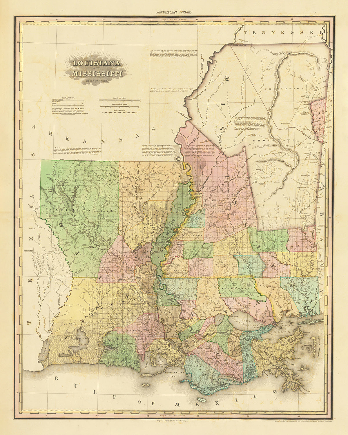
Immerse yourself in the rich history and fascinating geography of the Southern United States with this exquisite map of Louisiana and Mississippi, drawn by celebrated cartographer H. S. Tanner in 1820. This meticulously detailed reproduction showcases the precision and careful craftsmanship for which Tanner was renowned, depicting the region's settlements, natural landmarks, and geographical features with extraordinary clarity and accuracy. This map encapsulates a pivotal period in the history of these states, right after the War of 1812 and at the cusp of the westward expansion. It serves as a testament to the significant transformation that the landscape underwent during this time, making it a collector's dream and an irreplaceable addition to any history or cartography enthusiast's collection.
From burgeoning settlements and colonial outposts to rivers and natural landmarks that have shaped the states' identities, this map captures it all. Explore the geographical layout and historical significance of 30 towns, cities, counties, and colonies that existed in Louisiana and Mississippi by 1820. Not only does this map give you a detailed picture of the early 19th century South, but it also traces the evolution of the region from largely undeveloped territories to the vibrant states we know today.
Settlements & Notable Locations:
Louisiana:
- New Orleans (1718): The largest city, known for its vibrant music and Creole culture.
- Baton Rouge (1699): Now the state capital, it was a significant military and industrial center.
- Lafayette (1821): A hub of Acadian (Cajun) culture.
- Natchitoches (1714): The oldest permanent settlement in the Louisiana Purchase territory.
- Opelousas (1720): An important location for trading and farming.
- Alexandria (1805): An important hub for cotton and trade.
- Donaldsonville (1806): Former capital of Louisiana.
- Plaquemine (1775): An important site for trade on the Mississippi River.
- Houma (1810): Known for its proximity to fertile fishing grounds.
- Monroe (1785): A center for steamboat trade.
- Thibodaux (1790): Known for sugar production.
- Avery Island (1818): Home to the famous Tabasco factory and a bird sanctuary.
- Pointe Coupee Parish (1722): Known for its Creole and Cajun populations and historically significant for sugar plantations.
- St. Martinville (1753): The so-called "Heart of the Acadiana" where Acadians first arrived.
- Napoleonville (1807): The parish seat of Assumption Parish, known for its plantation estates.
Mississippi:
- Jackson (1821): The capital and most populous city, named after Andrew Jackson.
- Natchez (1716): One of the oldest settlements, known for its antebellum architecture.
- Biloxi (1699): A popular seaside destination.
- Vicksburg (1811): Known for its Civil War history.
- Columbus (1821): Known for its historic homes.
- Gulfport (1887): Popular location for water sports and fishing.
- Greenwood (1830): Known for cotton growing and shipping.
- Woodville (1809): Notable for its historic buildings and the boyhood home of U.S. President Jefferson Davis.
- Port Gibson (1783): Known for the Windsor Ruins and many historic churches.
- Yazoo City (1824): The "Gateway to the Delta", famous for its historic buildings.
- Ocean Springs (1699): Known for its art community and natural beauty.
- Pascagoula (1720): An important early shipbuilding center.
- Bay St. Louis (1818): Known for its beaches and casinos.
- Pass Christian (1830): Noted for its historic mansions and seaside location.
- Holly Springs (1836): Known for its antebellum homes and historic square.
Natural Phenomena & Landmarks:
- Mississippi River: A significant and historic transportation route.
- Lake Pontchartrain: The second-largest saltwater lake in the United States.
- Bayou Teche: A significant waterway in the Atchafalaya National Heritage Area.
- Pearl River: Forms part of the boundary between Louisiana and Mississippi.
Historical Events (1815-1820):
- Battle of New Orleans (1815): The final major battle of the War of 1812.
- The Treaty of Doak's Stand (1820): Negotiated with the Choctaw Nation to give up a significant portion of their land in Mississippi.
Please double check the images to make sure that a specific town or place is shown on this map. You can also get in touch and ask us to check the map for you.
This map looks great at all sizes, but it looks even better when printed large.
I can create beautiful, large prints of this map up to 100in (254cm). Please get in touch if you're looking for larger, customised or different framing options.
The model in the listing images is holding the 16x20in (40.5x51cm) version of this map.
The fifth listing image shows an example of my map personalisation service.
If you’re looking for something slightly different, check out my main collection of USA and North America maps.
Please contact me to check if a certain location, landmark or feature is shown on this map.
This would make a wonderful birthday, Christmas, Father's Day, work leaving, anniversary or housewarming gift for someone from the areas covered by this map.
This map is available as a giclée print on acid free archival matte paper, or you can buy it framed. The frame is a nice, simple black frame that suits most aesthetics. Please get in touch if you'd like a different frame colour or material. My frames are glazed with super-clear museum-grade acrylic (perspex/acrylite), which is significantly less reflective than glass, safer, and will always arrive in perfect condition.
This map is also available as a float framed canvas, sometimes known as a shadow gap framed canvas or canvas floater. The map is printed on artist's cotton canvas and then stretched over a handmade box frame. We then "float" the canvas inside a wooden frame, which is available in a range of colours (black, dark brown, oak, antique gold and white). This is a wonderful way to present a map without glazing in front. See some examples of float framed canvas maps and explore the differences between my different finishes.
For something truly unique, this map is also available in "Unique 3D", our trademarked process that dramatically transforms the map so that it has a wonderful sense of depth. We combine the original map with detailed topography and elevation data, so that mountains and the terrain really "pop". For more info and examples of 3D maps, check my Unique 3D page.
Many of our maps and art prints are chosen as thoughtful gifts for homes, offices, studies and meaningful places.
Choose a framed option for the easiest ready-to-hang gift, or choose an unframed print if the recipient may prefer to select their own frame.
We make orders locally in 23 countries around the world, so gifts can often be produced close to the recipient. This helps them arrive faster, travel more safely, and avoid customs or import duty surprises.
- We can deliver directly to the recipient
- Framed pieces arrive ready to hang
- Unframed prints are carefully packed in a strong protective tube
- Almost every order is made locally, for faster, safer gifting
- 90-day returns give the recipient time to decide
If you are not sure what to choose, please contact us. We can help you pick the right map, size, finish or delivery option.
Most orders are made locally and delivered in around 2–3 working days, depending on the product, size and destination.
We print and frame maps and artwork in 23 countries around the world, so your order is usually made close to you or your recipient. That means faster delivery, less time in transit, and no customs or import duty surprises.
Personalised and customised pieces usually take an extra 1–2 working days, because we prepare your design and send it to you for approval before printing.
Very large framed orders can take a little longer, as they need extra care in production and delivery.
Every order is carefully packaged: unframed prints are sent in a strong protective tube, while framed pieces are securely packed with protective materials around the frame.
If you need your order by a particular date, please contact us before ordering. We’ll check the best production route and delivery option for your location.
Express delivery is available at checkout for most countries. Next-day delivery is available in the UK, US, Singapore and the UAE.
Your order is covered by our 90-day returns policy and 10-year guarantee.
Our standard frame is a gallery-style black ash hardwood frame, with a simple, modern look. It is approximately 20mm (0.8in) wide. You can also view some lovely customer photos of framed maps and art.
We use super-clear acrylic glazing, also known as Perspex or Acrylite, instead of traditional glass. It is lighter, safer, and has lower reflectivity, giving the artwork a clearer, cleaner appearance.
Six standard frame colours are available at no extra cost: black, dark brown, dark grey, oak, white, and antique gold. Custom framing and mounting/matting is also available for customers looking for something more specific.
Most maps, art prints, and illustrations are also available as a framed canvas. We use matte cotton canvas, stretch it over a sustainably sourced wooden box frame, and then float the piece within a wooden outer frame. The finished result is beautifully presented, with no glazing between you and the artwork.
All frames are supplied ready to hang, with either string or brackets fitted to the back. Very large frames will include heavy-duty hanging plates and/or a mounting baton. If you have any questions, please get in touch.
We can also supply old maps and artwork on canvas, foam board, cotton rag, and other materials.
If you would prefer to frame your map or artwork yourself, please read our size guide before ordering.
My maps are extremely high quality reproductions of original maps.
I source original, rare maps from libraries, auction houses and private collections around the world, restore them at my London workshop, and then use specialist giclée inks and printers to create beautiful maps that look even better than the original.
My maps are printed on acid-free archival matte (not glossy) paper that feels very high quality and almost like card. In technical terms the paper weight/thickness is 10mil/200gsm. It's perfect for framing.
I print with Epson ultrachrome giclée UV fade resistant pigment inks - some of the best inks you can find.
I can also make maps on canvas, cotton rag and other exotic materials.
Learn more about The Unique Maps Co.
Map personalisation
If you're looking for the perfect anniversary or housewarming gift, I can personalise your map to make it truly unique. For example, I can add a short message, or highlight an important location, or add your family's coat of arms.
The options are almost infinite. Please see my map personalisation page for some wonderful examples of what's possible.
To order a personalised map, select "personalise your map" before adding it to your basket.
Get in touch if you're looking for more complex customisations and personalisations.
Map ageing
I have been asked hundreds of times over the years by customers if they could buy a map that looks even older.
Well, now you can, by selecting Aged before you add a map to your basket.
All the product photos you see on this page show the map in its Original form. This is what the map looks like today.
If you select Aged, I will age your map by hand, using a special and unique process developed through years of studying old maps, talking to researchers to understand the chemistry of aging paper, and of course... lots of practice!
If you're unsure, stick to the Original colour of the map. If you want something a bit darker and older looking, go for Aged.
If you are not happy with your order for any reason, contact me and I'll get it fixed ASAP, free of charge. Please see my returns and refund policy for more information.
I am very confident you will like your restored map or art print. I have been doing this since 1984. I'm a 5-star Etsy seller. I have sold tens of thousands of maps and art prints and have over 5,000 real 5-star reviews. My work has been featured in interior design magazines, on the BBC, and on the walls of dozens of 5-star hotels.
I use a unique process to restore maps and artwork that is massively time consuming and labour intensive. Hunting down the original maps and illustrations can take months. I use state of the art and eye-wateringly expensive technology to scan and restore them. As a result, I guarantee my maps and art prints are a cut above the rest. I stand by my products and will always make sure you're 100% happy with what you receive.
Almost all of my maps and art prints look amazing at large sizes (200cm, 6.5ft+) and I can frame and deliver them to you as well, via special oversized courier. Contact me to discuss your specific needs.
Or try searching for something!


