


Rare Old Map of Milan by Pinchetti, 1801: Foro Bonaparte, Citadel, Naviglio Canal, Piazzas
20% off 2 — 33% off 3
Add any two eligible items to your bag to receive 20% off. Add a third and it will be complimentary (equivalent to 33% off when purchasing three).
No code needed — the offer applies automatically at checkout.
Valid on all standard maps and fine art prints. You can mix and match any designs.
If you’d like to ship items to multiple addresses, please contact us before placing your order.
Custom and bespoke commissions are excluded.
Contact us if you have any questions
 Designed in London Made in Australia
Designed in London • Made in Australia
Designed in London Made in Australia
Designed in London • Made in Australia

Restored from the original 1801 map and printed to museum-grade archival standards. Read the story behind this map
Choose your size
Choose your finish


(More info)
Gift message & custom finish

If you want to add a gift message, or a finish (jigsaw, aluminium board, etc.) that is not available here, please request it in the "order note" when you check out.
Every order is custom made, so if you need the size adjusted slightly, or printed on an unusual material, just let us know. We've done thousands of custom orders over the years, so there's (almost) nothing we can't manage.
You can also contact us before you order, if you prefer!

- Made locally for fast, safe delivery
- No import duty or hidden fees
- Need advice? Call us or message on WhatsApp
Own a piece of history
8,000+ five-star reviews


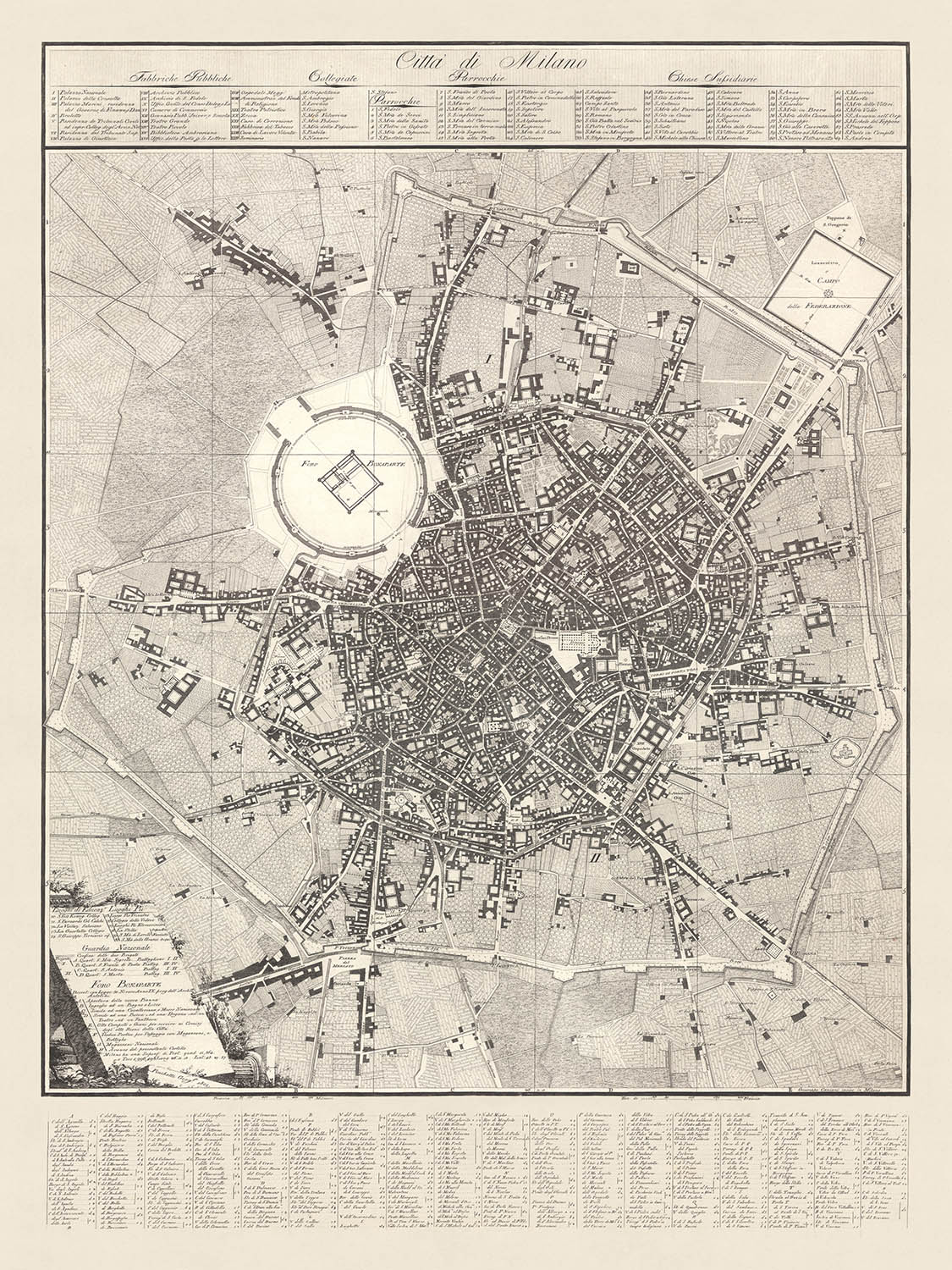
The "Città di Milano" map, meticulously crafted by Giacomo Pinchetti in 1801 and engraved by Giuseppe Caniani, is a remarkable testament to...
Continue readingThe "Città di Milano" map, meticulously crafted by Giacomo Pinchetti in 1801 and engraved by Giuseppe Caniani, is a remarkable testament to the urban and architectural grandeur of early 19th-century Milan. This exquisite map not only charts the intricate layout of Milan's streets and squares but also encapsulates the ambitious vision of the Napoleonic era, particularly through the proposed Foro Bonaparte project. This project, although never realized, envisioned a transformative urban space with a nearly square civil building at its heart, surrounded by public and private edifices, reflecting the grandiosity of Napoleonic urban planning.
One of the most captivating aspects of this map is its detailed representation of Milan's significant neighborhoods and landmarks. The Citadel of Milan, a focal point of the Foro Bonaparte project, is prominently featured, illustrating the intended transformation of this military stronghold into a civic center. The map also highlights the Naviglio Canal, designed to weave through the city, enhancing both its aesthetic appeal and functional connectivity. This canal was planned to exit the Customs area, run parallel to a continuous portico, and connect to the new road to France via Sempione, showcasing the integration of urban design and transportation.
In addition to its architectural and infrastructural elements, the map provides a comprehensive listing of Milan's public factories, collegiate churches, parishes, and subsidiary churches. These are meticulously cataloged in twelve columns at the top, offering a detailed snapshot of the city's religious and industrial landscape. The lower left corner of the map further enriches this historical tapestry by detailing places of education, pious places, and the National Guard, underscoring the multifaceted nature of Milanese society at the time.
The map's design is a masterclass in cartographic elegance, with graphic scales in Braccia Milanesi and Tese di Francia, providing precise measurements for contemporary and future reference. The eighteen columns at the bottom, listing the names of streets, squares, and gates, serve as a valuable directory, guiding the viewer through the labyrinthine streets of Milan. This detailed enumeration not only aids navigation but also offers insights into the urban fabric and nomenclature of the period.
Historically, the "Città di Milano" map is significant for its portrayal of an ambitious urban vision that, despite its non-realization, reflects the aspirations and dynamism of Napoleonic Milan. It stands as a valuable document for historians, urban planners, and enthusiasts of cartography, offering a window into the city's past and the grand designs that shaped its development. This map is not just a representation of Milan's streets and buildings; it is a narrative of a city's dreams and the historical forces that influenced its evolution.
Streets and roads on this map
- Corso di Porta Romana
- Corso di Porta Ticinese
- Corso di Porta Venezia
- Corso di Porta Vercellina
- Piazza del Duomo
- Piazza San Babila
- Piazza Santo Stefano
- Piazza dei Mercanti
- Piazza della Scala
- Piazza del Carmine
- Piazza di Santa Maria
- Piazza di Sant'Ambrogio
- Piazza di San Fedele
- Piazza del Castello
- Piazza Beccaria
- Piazza Fontana
- Piazza Cavour
- Piazza Sant'Alessandro
- Piazza San Sepolcro
- Piazza San Nazaro in Brolo
- Piazza San Marco
- Piazza San Simpliciano
- Piazza San Giovanni in Conca
- Piazza San Carlo
- Piazza San Lorenzo
- Piazza San Maurilio
- Piazza Santa Maria alla Porta
- Piazza San Bernardino alle Ossa
- Piazza San Francesco di Paola
- Piazza San Vittore al Corpo
Notable Features & Landmarks
- Illustrations:
- Detailed engravings of buildings and city layout.
- Landmarks:
- Foro Bonaparte (project area).
- Citadel of Milan.
- Neighbourhoods:
- Various city districts are detailed.
- Large parks:
- The area around the Citadel appears to be planned as open space in the Foro Bonaparte project.
Historical and design context
- Name of the map: Città di Milano
- Date of creation: 1801
- Mapmaker/Publisher: Giacomo Pinchetti, engraved by Giuseppe Caniani
- Public Factories, Collegiate Churches, Parishes, and Subsidiary Churches: Listed in twelve columns at the top.
- Names of streets, squares, and gates: Included in eighteen columns at the bottom.
- Places of Education, Pious Places, National Guard, and Bonaparte Forum references: Detailed in the lower left corner with references according to the Antolini project.
- Graphic scales: Braccia Milanesi and Tese di Francia.
- Foro Bonaparte project by Antolini: A significant Napoleonic-era project proposed to transform the Citadel of Milan with various public and private buildings, porticos, and a redesigned Naviglio Canal. Despite symbolic commencement in 1801, the project was never initiated.
- Urban planning and architecture: Emphasizes the Foro Bonaparte project.
- Religious and public institutions: Detailed listings of churches and public factories.
- Education and piety: Places of education and pious places are noted.
- Countries and regions shown: The map focuses on the city of Milan, Italy.
- Design and style:
- Detailed street and building layout.
- Extensive use of lists and columns for categorizing information.
- Classical cartographic elements with scales in local units.
- Historical significance:
- Provides insight into early 19th-century Milanese urban planning.
- Reflects Napoleonic influence on city development.
- Documents an ambitious but unrealized urban transformation project.
Please double check the images to make sure that a specific town or place is shown on this map. You can also get in touch and ask us to check the map for you.
This map looks great at every size, but I always recommend going for a larger size if you have space. That way you can easily make out all of the details.
This map looks amazing at sizes all the way up to 100in (250cm). If you are looking for a larger map, please get in touch.
Please note: the labels on this map are hard to read if you order a map that is 20in (50cm) or smaller. The map is still very attractive, but if you would like to read the map easily, please buy a larger size.
The model in the listing images is holding the 18x24in (45x60cm) version of this map.
The fifth listing image shows an example of my map personalisation service.
If you’re looking for something slightly different, check out my collection of the best old maps to see if something else catches your eye.
Please contact me to check if a certain location, landmark or feature is shown on this map.
This would make a wonderful birthday, Christmas, Father's Day, work leaving, anniversary or housewarming gift for someone from the areas covered by this map.
This map is available as a giclée print on acid free archival matte paper, or you can buy it framed. The frame is a nice, simple black frame that suits most aesthetics. Please get in touch if you'd like a different frame colour or material. My frames are glazed with super-clear museum-grade acrylic (perspex/acrylite), which is significantly less reflective than glass, safer, and will always arrive in perfect condition.
This map is also available as a float framed canvas, sometimes known as a shadow gap framed canvas or canvas floater. The map is printed on artist's cotton canvas and then stretched over a handmade box frame. We then "float" the canvas inside a wooden frame, which is available in a range of colours (black, dark brown, oak, antique gold and white). This is a wonderful way to present a map without glazing in front. See some examples of float framed canvas maps and explore the differences between my different finishes.
For something truly unique, this map is also available in "Unique 3D", our trademarked process that dramatically transforms the map so that it has a wonderful sense of depth. We combine the original map with detailed topography and elevation data, so that mountains and the terrain really "pop". For more info and examples of 3D maps, check my Unique 3D page.
The "Città di Milano" map, meticulously crafted by Giacomo Pinchetti in 1801 and engraved by Giuseppe Caniani, is a remarkable testament to the urban and architectural grandeur of early 19th-century Milan. This exquisite map not only charts the intricate layout of Milan's streets and squares but also encapsulates the ambitious vision of the Napoleonic era, particularly through the proposed Foro Bonaparte project. This project, although never realized, envisioned a transformative urban space with a nearly square civil building at its heart, surrounded by public and private edifices, reflecting the grandiosity of Napoleonic urban planning.
One of the most captivating aspects of this map is its detailed representation of Milan's significant neighborhoods and landmarks. The Citadel of Milan, a focal point of the Foro Bonaparte project, is prominently featured, illustrating the intended transformation of this military stronghold into a civic center. The map also highlights the Naviglio Canal, designed to weave through the city, enhancing both its aesthetic appeal and functional connectivity. This canal was planned to exit the Customs area, run parallel to a continuous portico, and connect to the new road to France via Sempione, showcasing the integration of urban design and transportation.
In addition to its architectural and infrastructural elements, the map provides a comprehensive listing of Milan's public factories, collegiate churches, parishes, and subsidiary churches. These are meticulously cataloged in twelve columns at the top, offering a detailed snapshot of the city's religious and industrial landscape. The lower left corner of the map further enriches this historical tapestry by detailing places of education, pious places, and the National Guard, underscoring the multifaceted nature of Milanese society at the time.
The map's design is a masterclass in cartographic elegance, with graphic scales in Braccia Milanesi and Tese di Francia, providing precise measurements for contemporary and future reference. The eighteen columns at the bottom, listing the names of streets, squares, and gates, serve as a valuable directory, guiding the viewer through the labyrinthine streets of Milan. This detailed enumeration not only aids navigation but also offers insights into the urban fabric and nomenclature of the period.
Historically, the "Città di Milano" map is significant for its portrayal of an ambitious urban vision that, despite its non-realization, reflects the aspirations and dynamism of Napoleonic Milan. It stands as a valuable document for historians, urban planners, and enthusiasts of cartography, offering a window into the city's past and the grand designs that shaped its development. This map is not just a representation of Milan's streets and buildings; it is a narrative of a city's dreams and the historical forces that influenced its evolution.
Streets and roads on this map
- Corso di Porta Romana
- Corso di Porta Ticinese
- Corso di Porta Venezia
- Corso di Porta Vercellina
- Piazza del Duomo
- Piazza San Babila
- Piazza Santo Stefano
- Piazza dei Mercanti
- Piazza della Scala
- Piazza del Carmine
- Piazza di Santa Maria
- Piazza di Sant'Ambrogio
- Piazza di San Fedele
- Piazza del Castello
- Piazza Beccaria
- Piazza Fontana
- Piazza Cavour
- Piazza Sant'Alessandro
- Piazza San Sepolcro
- Piazza San Nazaro in Brolo
- Piazza San Marco
- Piazza San Simpliciano
- Piazza San Giovanni in Conca
- Piazza San Carlo
- Piazza San Lorenzo
- Piazza San Maurilio
- Piazza Santa Maria alla Porta
- Piazza San Bernardino alle Ossa
- Piazza San Francesco di Paola
- Piazza San Vittore al Corpo
Notable Features & Landmarks
- Illustrations:
- Detailed engravings of buildings and city layout.
- Landmarks:
- Foro Bonaparte (project area).
- Citadel of Milan.
- Neighbourhoods:
- Various city districts are detailed.
- Large parks:
- The area around the Citadel appears to be planned as open space in the Foro Bonaparte project.
Historical and design context
- Name of the map: Città di Milano
- Date of creation: 1801
- Mapmaker/Publisher: Giacomo Pinchetti, engraved by Giuseppe Caniani
- Public Factories, Collegiate Churches, Parishes, and Subsidiary Churches: Listed in twelve columns at the top.
- Names of streets, squares, and gates: Included in eighteen columns at the bottom.
- Places of Education, Pious Places, National Guard, and Bonaparte Forum references: Detailed in the lower left corner with references according to the Antolini project.
- Graphic scales: Braccia Milanesi and Tese di Francia.
- Foro Bonaparte project by Antolini: A significant Napoleonic-era project proposed to transform the Citadel of Milan with various public and private buildings, porticos, and a redesigned Naviglio Canal. Despite symbolic commencement in 1801, the project was never initiated.
- Urban planning and architecture: Emphasizes the Foro Bonaparte project.
- Religious and public institutions: Detailed listings of churches and public factories.
- Education and piety: Places of education and pious places are noted.
- Countries and regions shown: The map focuses on the city of Milan, Italy.
- Design and style:
- Detailed street and building layout.
- Extensive use of lists and columns for categorizing information.
- Classical cartographic elements with scales in local units.
- Historical significance:
- Provides insight into early 19th-century Milanese urban planning.
- Reflects Napoleonic influence on city development.
- Documents an ambitious but unrealized urban transformation project.
Please double check the images to make sure that a specific town or place is shown on this map. You can also get in touch and ask us to check the map for you.
This map looks great at every size, but I always recommend going for a larger size if you have space. That way you can easily make out all of the details.
This map looks amazing at sizes all the way up to 100in (250cm). If you are looking for a larger map, please get in touch.
Please note: the labels on this map are hard to read if you order a map that is 20in (50cm) or smaller. The map is still very attractive, but if you would like to read the map easily, please buy a larger size.
The model in the listing images is holding the 18x24in (45x60cm) version of this map.
The fifth listing image shows an example of my map personalisation service.
If you’re looking for something slightly different, check out my collection of the best old maps to see if something else catches your eye.
Please contact me to check if a certain location, landmark or feature is shown on this map.
This would make a wonderful birthday, Christmas, Father's Day, work leaving, anniversary or housewarming gift for someone from the areas covered by this map.
This map is available as a giclée print on acid free archival matte paper, or you can buy it framed. The frame is a nice, simple black frame that suits most aesthetics. Please get in touch if you'd like a different frame colour or material. My frames are glazed with super-clear museum-grade acrylic (perspex/acrylite), which is significantly less reflective than glass, safer, and will always arrive in perfect condition.
This map is also available as a float framed canvas, sometimes known as a shadow gap framed canvas or canvas floater. The map is printed on artist's cotton canvas and then stretched over a handmade box frame. We then "float" the canvas inside a wooden frame, which is available in a range of colours (black, dark brown, oak, antique gold and white). This is a wonderful way to present a map without glazing in front. See some examples of float framed canvas maps and explore the differences between my different finishes.
For something truly unique, this map is also available in "Unique 3D", our trademarked process that dramatically transforms the map so that it has a wonderful sense of depth. We combine the original map with detailed topography and elevation data, so that mountains and the terrain really "pop". For more info and examples of 3D maps, check my Unique 3D page.
Many of our maps and art prints are chosen as thoughtful gifts for homes, offices, studies and meaningful places.
Choose a framed option for the easiest ready-to-hang gift, or choose an unframed print if the recipient may prefer to select their own frame.
We make orders locally in 23 countries around the world, so gifts can often be produced close to the recipient. This helps them arrive faster, travel more safely, and avoid customs or import duty surprises.
- We can deliver directly to the recipient
- Framed pieces arrive ready to hang
- Unframed prints are carefully packed in a strong protective tube
- Almost every order is made locally, for faster, safer gifting
- 90-day returns give the recipient time to decide
If you are not sure what to choose, please contact us. We can help you pick the right map, size, finish or delivery option.
Most orders are made locally and delivered in around 2–3 working days, depending on the product, size and destination.
We print and frame maps and artwork in 23 countries around the world, so your order is usually made close to you or your recipient. That means faster delivery, less time in transit, and no customs or import duty surprises.
Personalised and customised pieces usually take an extra 1–2 working days, because we prepare your design and send it to you for approval before printing.
Very large framed orders can take a little longer, as they need extra care in production and delivery.
Every order is carefully packaged: unframed prints are sent in a strong protective tube, while framed pieces are securely packed with protective materials around the frame.
If you need your order by a particular date, please contact us before ordering. We’ll check the best production route and delivery option for your location.
Express delivery is available at checkout for most countries. Next-day delivery is available in the UK, US, Singapore and the UAE.
Your order is covered by our 90-day returns policy and 10-year guarantee.
Our standard frame is a gallery-style black ash hardwood frame, with a simple, modern look. It is approximately 20mm (0.8in) wide. You can also view some lovely customer photos of framed maps and art.
We use super-clear acrylic glazing, also known as Perspex or Acrylite, instead of traditional glass. It is lighter, safer, and has lower reflectivity, giving the artwork a clearer, cleaner appearance.
Six standard frame colours are available at no extra cost: black, dark brown, dark grey, oak, white, and antique gold. Custom framing and mounting/matting is also available for customers looking for something more specific.
Most maps, art prints, and illustrations are also available as a framed canvas. We use matte cotton canvas, stretch it over a sustainably sourced wooden box frame, and then float the piece within a wooden outer frame. The finished result is beautifully presented, with no glazing between you and the artwork.
All frames are supplied ready to hang, with either string or brackets fitted to the back. Very large frames will include heavy-duty hanging plates and/or a mounting baton. If you have any questions, please get in touch.
We can also supply old maps and artwork on canvas, foam board, cotton rag, and other materials.
If you would prefer to frame your map or artwork yourself, please read our size guide before ordering.
My maps are extremely high quality reproductions of original maps.
I source original, rare maps from libraries, auction houses and private collections around the world, restore them at my London workshop, and then use specialist giclée inks and printers to create beautiful maps that look even better than the original.
My maps are printed on acid-free archival matte (not glossy) paper that feels very high quality and almost like card. In technical terms the paper weight/thickness is 10mil/200gsm. It's perfect for framing.
I print with Epson ultrachrome giclée UV fade resistant pigment inks - some of the best inks you can find.
I can also make maps on canvas, cotton rag and other exotic materials.
Learn more about The Unique Maps Co.
Map personalisation
If you're looking for the perfect anniversary or housewarming gift, I can personalise your map to make it truly unique. For example, I can add a short message, or highlight an important location, or add your family's coat of arms.
The options are almost infinite. Please see my map personalisation page for some wonderful examples of what's possible.
To order a personalised map, select "personalise your map" before adding it to your basket.
Get in touch if you're looking for more complex customisations and personalisations.
Map ageing
I have been asked hundreds of times over the years by customers if they could buy a map that looks even older.
Well, now you can, by selecting Aged before you add a map to your basket.
All the product photos you see on this page show the map in its Original form. This is what the map looks like today.
If you select Aged, I will age your map by hand, using a special and unique process developed through years of studying old maps, talking to researchers to understand the chemistry of aging paper, and of course... lots of practice!
If you're unsure, stick to the Original colour of the map. If you want something a bit darker and older looking, go for Aged.
If you are not happy with your order for any reason, contact me and I'll get it fixed ASAP, free of charge. Please see my returns and refund policy for more information.
I am very confident you will like your restored map or art print. I have been doing this since 1984. I'm a 5-star Etsy seller. I have sold tens of thousands of maps and art prints and have over 5,000 real 5-star reviews. My work has been featured in interior design magazines, on the BBC, and on the walls of dozens of 5-star hotels.
I use a unique process to restore maps and artwork that is massively time consuming and labour intensive. Hunting down the original maps and illustrations can take months. I use state of the art and eye-wateringly expensive technology to scan and restore them. As a result, I guarantee my maps and art prints are a cut above the rest. I stand by my products and will always make sure you're 100% happy with what you receive.
Almost all of my maps and art prints look amazing at large sizes (200cm, 6.5ft+) and I can frame and deliver them to you as well, via special oversized courier. Contact me to discuss your specific needs.
Or try searching for something!


