

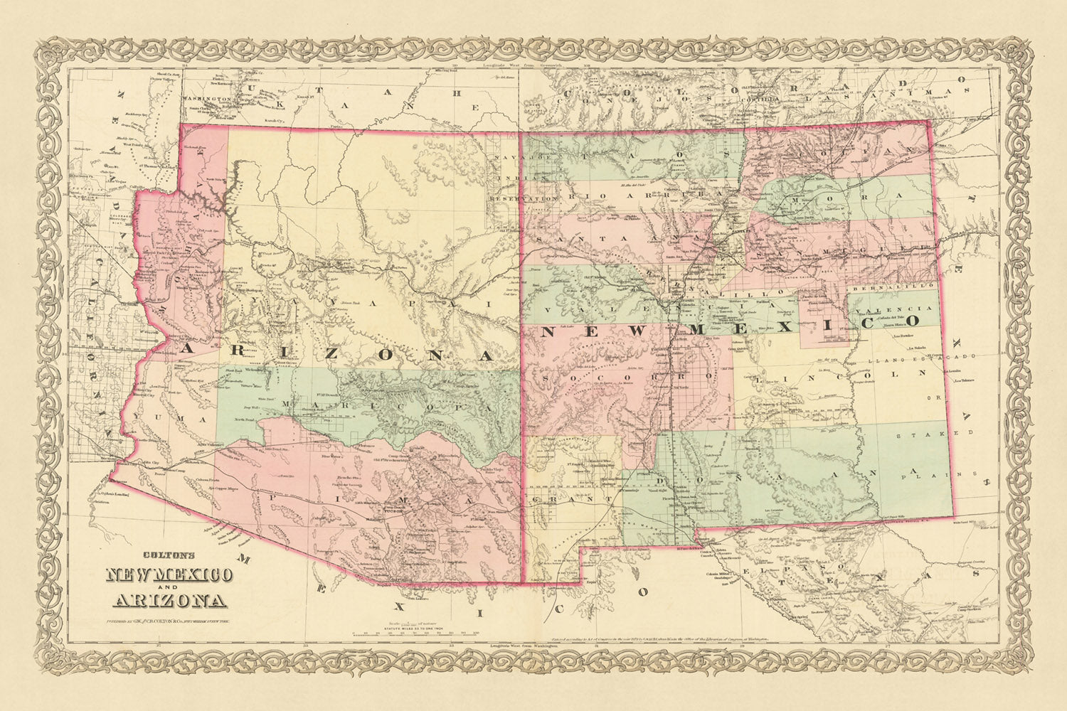


Rare Old Map of New Mexico & Arizona by Colton, 1873: Santa Fe, Tucson, Albuquerque, Prescott, and Mesilla
20% off 2 — 33% off 3
Add any two eligible items to your bag to receive 20% off. Add a third and it will be complimentary (equivalent to 33% off when purchasing three).
No code needed — the offer applies automatically at checkout.
Valid on all standard maps and fine art prints. You can mix and match any designs.
If you’d like to ship items to multiple addresses, please contact us before placing your order.
Custom and bespoke commissions are excluded.
Contact us if you have any questions
 Designed in London Made in Australia
Designed in London • Made in Australia
Designed in London Made in Australia
Designed in London • Made in Australia

Choose your size
Choose your finish


(More info)
Gift message & custom finish

If you want to add a gift message, or a finish (jigsaw, aluminium board, etc.) that is not available here, please request it in the "order note" when you check out.
Every order is custom made, so if you need the size adjusted slightly, or printed on an unusual material, just let us know. We've done thousands of custom orders over the years, so there's (almost) nothing we can't manage.
You can also contact us before you order, if you prefer!

- Made locally for fast, safe delivery
- No import duty or hidden fees
- Need advice? Message us on WhatsApp
Own a piece of history
7,000+ 5 star reviews


Immerse yourself in the rich history of the United States with this meticulously crafted 1873 map of New Mexico and Arizona, produced by renowned mapmaker J.H. Colton. This exquisite piece provides a rare glimpse into the early development of these regions, at a time when many settlements were still in their infancy and the landscape of the United States was rapidly evolving. As one of the finest American mapmakers of his era, Colton's work is characterized by its exceptional attention to detail and accuracy, offering a unique window into the past.
The 1873 map captures a fascinating snapshot of New Mexico and Arizona's early history. At this time, many of the cities and towns we know today were yet to be founded, and the names and borders that are so familiar to us now were still in flux. This map is a testament to the dynamic nature of history, reflecting the changing socio-political landscape of the time.
The five most notable settlements featured on this map are Santa Fe, Tucson, Albuquerque, Prescott, and Mesilla. Each of these locations holds a unique place in the history of the United States. Santa Fe, the oldest capital city in the United States, was already an established settlement by 1873. Tucson, a city with a rich indigenous history, was just beginning to grow. Albuquerque, now the most populous city in New Mexico, was then a small railroad town. Prescott, the territorial capital of Arizona at the time, was a hub of mining and commerce. Lastly, Mesilla, a town rich in history and culture, was a key player in the Gadsden Purchase.
As you explore this map, you'll be transported back to a time when the United States was still finding its shape. The borders, names, and settlements may have changed over the last 150 years, but the spirit of exploration and discovery that this map embodies remains as relevant today as it was in 1873. Whether you're a history enthusiast, a lover of maps, or simply someone who appreciates the artistry of J.H. Colton's work, this old map of New Mexico and Arizona is sure to captivate and inspire.
New Mexico
- Santa Fe (1610): Known as the oldest capital city in the United States, Santa Fe was originally occupied by Pueblo Indian villages.
- Albuquerque (1706): Originally named Ranchos de Albuquerque, it was a small farming community and military outpost along the Camino Real.
- Las Cruces (1849): Established during the California Gold Rush, it was a key stop on the Butterfield Overland Mail Route.
- Taos (1615): Known for the historic Taos Pueblo, a UNESCO World Heritage Site.
- Socorro (1598): Originally named Nuestra Señora de Perpetuo Socorro, it was a mission center for the surrounding Piro Pueblo.
- Los Lunas (1716): Named after the Luna family, early Spanish settlers in the region.
- Las Vegas (1835): Not to be confused with its namesake in Nevada, it was a key stop on the Santa Fe Trail.
- Bernalillo (1695): Known for the Coronado Historic Site, where the ruins of the ancient Pueblo of Kuaua are located.
- Silver City (1870): Founded after the discovery of silver ore deposits, it was the home of Billy the Kid.
- Mesilla (1848): Known for its adobe buildings and was a key player in the Gadsden Purchase.
Arizona
- Tucson (1775): Originally a Spanish military fort, it has a rich indigenous history.
- Prescott (1864): The territorial capital of Arizona, it was a hub of mining and commerce.
- Yuma (1854): Known for the Yuma Territorial Prison, a pioneer prison for the Arizona Territory.
- Phoenix (1867): Originally an agricultural community, it was named after the mythical bird that rose from its own ashes.
- Flagstaff (1876): Known for its proximity to the Grand Canyon, it was a key location on the Atlantic and Pacific Railroad.
- Florence (1866): Home to the oldest public building in Arizona, the Pinal County Courthouse.
- Tombstone (1877): Known for the Gunfight at the O.K. Corral, one of the most famous gunfights in the history of the American Wild West.
- Sedona (1876): Known for its vibrant arts community and stunning red rock formations.
- Winslow (1880): A key stop on the Santa Fe Railroad, it was immortalized in the Eagles' song "Take It Easy".
- Globe (1875): Founded as a mining camp, it was the site of the Old Dominion Copper Mine.
Native American Tribes
- Apache Tribe: Known for their fierce resistance against the encroachment of settlers.
- Navajo Tribe: The largest Native American tribe in the United States, known for their weaving and silver work.
- Hopi Tribe: Known for their pottery and the ancient village of Oraibi, one of the oldest continuously inhabited settlements in the United States.
- Pueblo Tribes: Known for their unique architecture and the ancient cliff dwellings at Bandelier National Monument.
- Zuni Tribe: Known for their intricate inlay jewelry and fetishes.
Notable Natural Features
- Grand Canyon: One of the seven natural wonders of the world, it offers breathtaking views of layered red rock.
- Petrified Forest National Park: Known for its large deposits of petrified wood.
- White Sands National Park: The world's largest gypsum dunefield.
- Saguaro National Park: Home to the nation's largest cacti, the giant saguaro.
- Chaco Culture National Historical Park: A UNESCO World Heritage Site, it was a major center of Puebloan culture.
Historical Events
- Mexican-American War (1846-1848): This conflict led to the Treaty of Guadalupe Hidalgo, which ended the war and ceded the territories of New Mexico and Arizona to the United States.
- Gadsden Purchase (1854): This land deal with Mexico added a portion of present-day southern Arizona and southwestern New Mexico to the U.S.
- Navajo Long Walk (1864): Over 8,000 Navajo were forced to march from Arizona to New Mexico in an event that is now known as the Long Walk of the Navajo.
- Apache Wars (1861-1886): A series of armed conflicts between the United States and various Apache nations.
Please double check the images to make sure that a specific town or place is shown on this map. You can also get in touch and ask us to check the map for you.
This map looks great at all sizes, but it looks even better when printed large.
I can create beautiful, large prints of this map up to 100in (254cm). Please get in touch if you're looking for larger, customised or different framing options.
The model in the listing images is holding the 24x36in (61x91.5cm) version of this map.
The fifth listing image shows an example of my map personalisation service.
The labels on this map are very small at 12x16in (30.5x41cm). The map is still very attractive, but you may struggle to read the smallest letters. Please buy a larger map if it's important to be able to read the map easily.
If you’re looking for something slightly different, check out my main collection of USA and North America maps.
Please contact me to check if a certain location, landmark or feature is shown on this map.
This would make a wonderful birthday, Christmas, Father's Day, work leaving, anniversary or housewarming gift for someone from the areas covered by this map.
This map is available as a giclée print on acid free archival matte paper, or you can buy it framed. The frame is a nice, simple black frame that suits most aesthetics. Please get in touch if you'd like a different frame colour or material. My frames are glazed with super-clear museum-grade acrylic (perspex/acrylite), which is significantly less reflective than glass, safer, and will always arrive in perfect condition.
This map is also available as a float framed canvas, sometimes known as a shadow gap framed canvas or canvas floater. The map is printed on artist's cotton canvas and then stretched over a handmade box frame. We then "float" the canvas inside a wooden frame, which is available in a range of colours (black, dark brown, oak, antique gold and white). This is a wonderful way to present a map without glazing in front. See some examples of float framed canvas maps and explore the differences between my different finishes.
For something truly unique, this map is also available in "Unique 3D", our trademarked process that dramatically transforms the map so that it has a wonderful sense of depth. We combine the original map with detailed topography and elevation data, so that mountains and the terrain really "pop". For more info and examples of 3D maps, check my Unique 3D page.
Many of our maps and art prints are chosen as thoughtful gifts for homes, offices, studies and meaningful places.
Choose a framed option for the easiest ready-to-hang gift, or choose an unframed print if the recipient may prefer to select their own frame.
We make orders locally in 23 countries around the world, so gifts can often be produced close to the recipient. This helps them arrive faster, travel more safely, and avoid customs or import duty surprises.
- We can deliver directly to the recipient
- Framed pieces arrive ready to hang
- Unframed prints are carefully packed in a strong protective tube
- Almost every order is made locally, for faster, safer gifting
- 90-day returns give the recipient time to decide
If you are not sure what to choose, please contact us. We can help you pick the right map, size, finish or delivery option.
Most orders are made locally and delivered in around 2–3 working days, depending on the product, size and destination.
We print and frame maps and artwork in 23 countries around the world, so your order is usually made close to you or your recipient. That means faster delivery, less time in transit, and no customs or import duty surprises.
Personalised and customised pieces usually take an extra 1–2 working days, because we prepare your design and send it to you for approval before printing.
Very large framed orders can take a little longer, as they need extra care in production and delivery.
Every order is carefully packaged: unframed prints are sent in a strong protective tube, while framed pieces are securely packed with protective materials around the frame.
If you need your order by a particular date, please contact us before ordering. We’ll check the best production route and delivery option for your location.
Express delivery is available at checkout for most countries. Next-day delivery is available in the UK, US, Singapore and the UAE.
Your order is covered by our 90-day returns policy and 10-year guarantee.
Our standard frame is a gallery-style black ash hardwood frame, with a simple, modern look. It is approximately 20mm (0.8in) wide. You can also view some lovely customer photos of framed maps and art.
We use super-clear acrylic glazing, also known as Perspex or Acrylite, instead of traditional glass. It is lighter, safer, and has lower reflectivity, giving the artwork a clearer, cleaner appearance.
Six standard frame colours are available at no extra cost: black, dark brown, dark grey, oak, white, and antique gold. Custom framing and mounting/matting is also available for customers looking for something more specific.
Most maps, art prints, and illustrations are also available as a framed canvas. We use matte cotton canvas, stretch it over a sustainably sourced wooden box frame, and then float the piece within a wooden outer frame. The finished result is beautifully presented, with no glazing between you and the artwork.
All frames are supplied ready to hang, with either string or brackets fitted to the back. Very large frames will include heavy-duty hanging plates and/or a mounting baton. If you have any questions, please get in touch.
We can also supply old maps and artwork on canvas, foam board, cotton rag, and other materials.
If you would prefer to frame your map or artwork yourself, please read our size guide before ordering.
My maps are extremely high quality reproductions of original maps.
I source original, rare maps from libraries, auction houses and private collections around the world, restore them at my London workshop, and then use specialist giclée inks and printers to create beautiful maps that look even better than the original.
My maps are printed on acid-free archival matte (not glossy) paper that feels very high quality and almost like card. In technical terms the paper weight/thickness is 10mil/200gsm. It's perfect for framing.
I print with Epson ultrachrome giclée UV fade resistant pigment inks - some of the best inks you can find.
I can also make maps on canvas, cotton rag and other exotic materials.
Learn more about The Unique Maps Co.
Map personalisation
If you're looking for the perfect anniversary or housewarming gift, I can personalise your map to make it truly unique. For example, I can add a short message, or highlight an important location, or add your family's coat of arms.
The options are almost infinite. Please see my map personalisation page for some wonderful examples of what's possible.
To order a personalised map, select "personalise your map" before adding it to your basket.
Get in touch if you're looking for more complex customisations and personalisations.
Map ageing
I have been asked hundreds of times over the years by customers if they could buy a map that looks even older.
Well, now you can, by selecting Aged before you add a map to your basket.
All the product photos you see on this page show the map in its Original form. This is what the map looks like today.
If you select Aged, I will age your map by hand, using a special and unique process developed through years of studying old maps, talking to researchers to understand the chemistry of aging paper, and of course... lots of practice!
If you're unsure, stick to the Original colour of the map. If you want something a bit darker and older looking, go for Aged.
If you are not happy with your order for any reason, contact me and I'll get it fixed ASAP, free of charge. Please see my returns and refund policy for more information.
I am very confident you will like your restored map or art print. I have been doing this since 1984. I'm a 5-star Etsy seller. I have sold tens of thousands of maps and art prints and have over 5,000 real 5-star reviews. My work has been featured in interior design magazines, on the BBC, and on the walls of dozens of 5-star hotels.
I use a unique process to restore maps and artwork that is massively time consuming and labour intensive. Hunting down the original maps and illustrations can take months. I use state of the art and eye-wateringly expensive technology to scan and restore them. As a result, I guarantee my maps and art prints are a cut above the rest. I stand by my products and will always make sure you're 100% happy with what you receive.
Almost all of my maps and art prints look amazing at large sizes (200cm, 6.5ft+) and I can frame and deliver them to you as well, via special oversized courier. Contact me to discuss your specific needs.
Or try searching for something!


