


Rare Old Map of New South Wales and Victoria by Arrowsmith 1844: Sydney, Melbourne, Port Phillip, Bass Strait, routes 1817–40
20% off 2 — 33% off 3
Add any two eligible items to your bag to receive 20% off. Add a third and it will be complimentary (equivalent to 33% off when purchasing three).
No code needed — the offer applies automatically at checkout.
Valid on all standard maps and fine art prints. You can mix and match any designs.
If you’d like to ship items to multiple addresses, please contact us before placing your order.
Custom and bespoke commissions are excluded.
Contact us if you have any questions
 Designed in London Made in Australia
Designed in London • Made in Australia
Designed in London Made in Australia
Designed in London • Made in Australia

Choose your size
Choose your finish


(More info)
Gift message & custom finish

If you want to add a gift message, or a finish (jigsaw, aluminium board, etc.) that is not available here, please request it in the "order note" when you check out.
Every order is custom made, so if you need the size adjusted slightly, or printed on an unusual material, just let us know. We've done thousands of custom orders over the years, so there's (almost) nothing we can't manage.
You can also contact us before you order, if you prefer!

- Made locally for fast, safe delivery
- No import duty or hidden fees
- Need advice? Message us on WhatsApp
Own a piece of history
7,000+ 5 star reviews


South Eastern Portion of Australia, issued in 1844 by John Arrowsmith, captures a continent on the cusp of transformation with the cool assurance of a master cartographer. The title signals his focus with unflinching precision: a judicious portrait of New South Wales and the Port Phillip District at a moment when counties, routes, and rivers were instruments of policy as much as geography. Arrowsmith’s signature outline color distinguishes counties and numbers them for swift reference, while a clear legend translates chromatic grace into practical intelligence. Issued amid the evolution of his celebrated atlas—whose expanded 1842 issue, with additional maps through 1844, is noted as an unrecorded variant by Verner, Phillips, and the British Museum—this map exemplifies the mid-century shift toward modern, information-rich design paired with spare, luminous elegance.
Arrowsmith’s design marries restraint with depth. Counties are washed in lucid tones and crisply numbered, their borders threaded across a terrain rendered through disciplined hachures that articulate the fall of land and the drama of elevation. Rivers are named with measured clarity—arteries that organize both settlement and imagination—while the great watershed of the interior is implied by the careful pull of tributaries running toward the south and west. Coastal forms are delineated with the delicacy of a draftsman: from the scalloped inlets around Port Jackson to the generous sweep of Port Phillip and the hard, oblique line of Bass Strait. The legend/key distills the visual system, allowing the viewer to navigate political divisions and physical geography with equal confidence.
The human geography is as telling as the physical. Sydney anchors the littoral world of New South Wales, its relationships to Newcastle and Wollongong traced along coast and river valleys that feed into the Hunter and Illawarra districts. Southward, in the Port Phillip District, Melbourne and Geelong appear as ascendant colonial towns, set against the estuarine breadth of Port Phillip and the lattice of rivers that would power trade and pastoral expansion. The counties that frame them—meticulously differentiated and cross-referenced—suggest a colonial order being mapped into existence. Roads and tracks are implied by alignments of settlement, ferries, and ports, while hinterlands begin to resolve into recognizable districts: places where naming, measuring, and jurisdiction were precursors to governance and commerce.
Perhaps the most evocative threads on the sheet are the routes of travelers into the interior, spanning 1817 to 1840. These lines press westward over the ranges and south across the plains, each bearing dates and directional cues that tether story to space. They record the audacity and contingency of exploration—episodic, cumulative, and often indebted to Aboriginal knowledge—linking coast to interior through a sequence of trials, river crossings, and passes. In frontier districts, Arrowsmith observes varying topographic textures and, where contemporary sources allowed, acknowledges cultural or territorial notes that shadow the colonial grid. The map becomes a palimpsest: the stable geometry of counties overlaying the more fluid itineraries of discovery that preceded them.
John Arrowsmith’s authority radiates from every decision. Nephew and heir to the Arrowsmith cartographic legacy, he drew upon Admiralty surveys, colonial dispatches, and explorers’ journals to synthesize the most reliable portrait available to London and the world. This 1844 sheet embodies the exploratory spirit and the administrative momentum of the nineteenth century: lucid in design, scrupulous in compilation, and forward-looking in its embrace of standardized color and intelligible referencing. It sits within an atlas program that, by the mid-1840s, had grown beyond its 1842 contours—adding fifteen new maps, including the scarce 1843 Texas—and now recognized by leading bibliographers as an unrecorded variant. For the discerning collector, it is a work of clarity and consequence: elegant, exacting, and historically resonant.
Cities and towns on this map
- Sydney (modern-day population: 5.3 million)
- Newcastle (modern-day population: 322,000)
- Wollongong (modern-day population: 300,000)
- Melbourne (modern-day population: 5 million)
- Geelong (modern-day population: 250,000)
Notable Features & Landmarks
- Detailed outlines of terrain and physical geographic features (e.g., mountains, rivers)
- Color-coded counties, each numbered for easy reference
- A detailed legend/key explaining color distinctions
- Routes of travelers into the interior clearly marked
- Notable rivers and lakes named and located
- Indication of indigenous territories or notable tribal regions (if applicable)
- Markings of exploratory expeditions conducted prior to 1840
- Areas depicted with varying topographic features
Historical and design context
- Date created: 1844
- Mapmaker: John Arrowsmith, a noted cartographer known for his accurate maps and innovative designs, which contributed significantly to cartography during the 19th century.
- This atlas is an exemplary piece reflecting elegance and clarity, marking a shift to modern atlas design in the 19th century.
- The 1842 edition includes an additional fifteen maps, including a rare Map of Texas from 1843 and several maps dated 1844; it’s noted as an unrecorded edition in Verner, Phillips, and the British Museum.
- Design/style context: The outline color design with differentiated counties enhances both the aesthetic and functional aspects of the map, making it an educational tool.
- Historical significance: This map exemplifies the exploratory spirit of the 19th century and reflects the colonial endeavors in Australia during a pivotal period of its development.
Please double check the images to make sure that a specific town or place is shown on this map. You can also get in touch and ask us to check the map for you.
This map looks great at every size, but I always recommend going for a larger size if you have space. That way you can easily make out all of the details.
This map looks amazing at sizes all the way up to 70in (180cm). If you are looking for a larger map, please get in touch.
Please note: the labels on this map are hard to read if you order a map that is 20in (50cm) or smaller. The map is still very attractive, but if you would like to read the map easily, please buy a larger size.
The model in the listing images is holding the 16x20in (40x50cm) version of this map.
The fifth listing image shows an example of my map personalisation service.
If you’re looking for something slightly different, check out my collection of the best old maps to see if something else catches your eye.
Please contact me to check if a certain location, landmark or feature is shown on this map.
This would make a wonderful birthday, Christmas, Father's Day, work leaving, anniversary or housewarming gift for someone from the areas covered by this map.
This map is available as a giclée print on acid free archival matte paper, or you can buy it framed. The frame is a nice, simple black frame that suits most aesthetics. Please get in touch if you'd like a different frame colour or material. My frames are glazed with super-clear museum-grade acrylic (perspex/acrylite), which is significantly less reflective than glass, safer, and will always arrive in perfect condition.
This map is also available as a float framed canvas, sometimes known as a shadow gap framed canvas or canvas floater. The map is printed on artist's cotton canvas and then stretched over a handmade box frame. We then "float" the canvas inside a wooden frame, which is available in a range of colours (black, dark brown, oak, antique gold and white). This is a wonderful way to present a map without glazing in front. See some examples of float framed canvas maps and explore the differences between my different finishes.
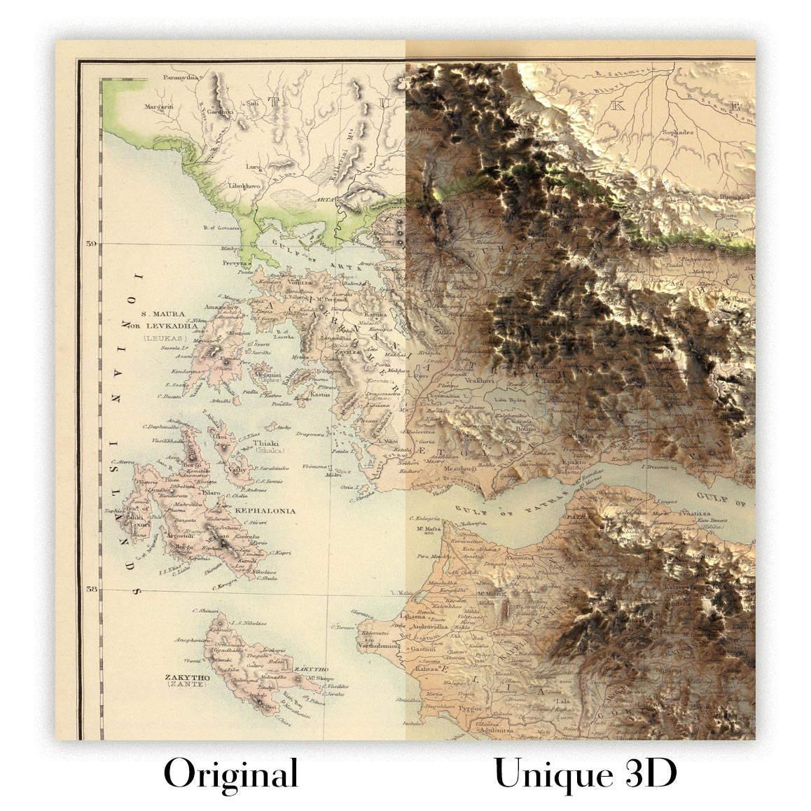
For something truly unique, this map is also available in "Unique 3D", our trademarked process that dramatically transforms the map so that it has a wonderful sense of depth. We combine the original map with detailed topography and elevation data, so that mountains and the terrain really "pop". For more info and examples of 3D maps, check my Unique 3D page.
Many of our maps and art prints are chosen as thoughtful gifts for homes, offices, studies and meaningful places.
Choose a framed option for the easiest ready-to-hang gift, or choose an unframed print if the recipient may prefer to select their own frame.
We make orders locally in 23 countries around the world, so gifts can often be produced close to the recipient. This helps them arrive faster, travel more safely, and avoid customs or import duty surprises.
- We can deliver directly to the recipient
- Framed pieces arrive ready to hang
- Unframed prints are carefully packed in a strong protective tube
- Almost every order is made locally, for faster, safer gifting
- 90-day returns give the recipient time to decide
If you are not sure what to choose, please contact us. We can help you pick the right map, size, finish or delivery option.
Most orders are made locally and delivered in around 2–3 working days, depending on the product, size and destination.
We print and frame maps and artwork in 23 countries around the world, so your order is usually made close to you or your recipient. That means faster delivery, less time in transit, and no customs or import duty surprises.
Personalised and customised pieces usually take an extra 1–2 working days, because we prepare your design and send it to you for approval before printing.
Very large framed orders can take a little longer, as they need extra care in production and delivery.
Every order is carefully packaged: unframed prints are sent in a strong protective tube, while framed pieces are securely packed with protective materials around the frame.
If you need your order by a particular date, please contact us before ordering. We’ll check the best production route and delivery option for your location.
Express delivery is available at checkout for most countries. Next-day delivery is available in the UK, US, Singapore and the UAE.
Your order is covered by our 90-day returns policy and 10-year guarantee.
Our standard frame is a gallery-style black ash hardwood frame, with a simple, modern look. It is approximately 20mm (0.8in) wide. You can also view some lovely customer photos of framed maps and art.
We use super-clear acrylic glazing, also known as Perspex or Acrylite, instead of traditional glass. It is lighter, safer, and has lower reflectivity, giving the artwork a clearer, cleaner appearance.
Six standard frame colours are available at no extra cost: black, dark brown, dark grey, oak, white, and antique gold. Custom framing and mounting/matting is also available for customers looking for something more specific.
Most maps, art prints, and illustrations are also available as a framed canvas. We use matte cotton canvas, stretch it over a sustainably sourced wooden box frame, and then float the piece within a wooden outer frame. The finished result is beautifully presented, with no glazing between you and the artwork.
All frames are supplied ready to hang, with either string or brackets fitted to the back. Very large frames will include heavy-duty hanging plates and/or a mounting baton. If you have any questions, please get in touch.
We can also supply old maps and artwork on canvas, foam board, cotton rag, and other materials.
If you would prefer to frame your map or artwork yourself, please read our size guide before ordering.
My maps are extremely high quality reproductions of original maps.
I source original, rare maps from libraries, auction houses and private collections around the world, restore them at my London workshop, and then use specialist giclée inks and printers to create beautiful maps that look even better than the original.
My maps are printed on acid-free archival matte (not glossy) paper that feels very high quality and almost like card. In technical terms the paper weight/thickness is 10mil/200gsm. It's perfect for framing.
I print with Epson ultrachrome giclée UV fade resistant pigment inks - some of the best inks you can find.
I can also make maps on canvas, cotton rag and other exotic materials.
Learn more about The Unique Maps Co.
Map personalisation
If you're looking for the perfect anniversary or housewarming gift, I can personalise your map to make it truly unique. For example, I can add a short message, or highlight an important location, or add your family's coat of arms.
The options are almost infinite. Please see my map personalisation page for some wonderful examples of what's possible.
To order a personalised map, select "personalise your map" before adding it to your basket.
Get in touch if you're looking for more complex customisations and personalisations.
Map ageing
I have been asked hundreds of times over the years by customers if they could buy a map that looks even older.
Well, now you can, by selecting Aged before you add a map to your basket.
All the product photos you see on this page show the map in its Original form. This is what the map looks like today.
If you select Aged, I will age your map by hand, using a special and unique process developed through years of studying old maps, talking to researchers to understand the chemistry of aging paper, and of course... lots of practice!
If you're unsure, stick to the Original colour of the map. If you want something a bit darker and older looking, go for Aged.
If you are not happy with your order for any reason, contact me and I'll get it fixed ASAP, free of charge. Please see my returns and refund policy for more information.
I am very confident you will like your restored map or art print. I have been doing this since 1984. I'm a 5-star Etsy seller. I have sold tens of thousands of maps and art prints and have over 5,000 real 5-star reviews. My work has been featured in interior design magazines, on the BBC, and on the walls of dozens of 5-star hotels.
I use a unique process to restore maps and artwork that is massively time consuming and labour intensive. Hunting down the original maps and illustrations can take months. I use state of the art and eye-wateringly expensive technology to scan and restore them. As a result, I guarantee my maps and art prints are a cut above the rest. I stand by my products and will always make sure you're 100% happy with what you receive.
Almost all of my maps and art prints look amazing at large sizes (200cm, 6.5ft+) and I can frame and deliver them to you as well, via special oversized courier. Contact me to discuss your specific needs.
Or try searching for something!


