


Rare Old Map of the Himalayas by Petermann, 1868: Everest, Sikkim, Bhutan, Tibet
20% off 2 — 33% off 3
Add any two eligible items to your bag to receive 20% off. Add a third and it will be complimentary (equivalent to 33% off when purchasing three).
No code needed — the offer applies automatically at checkout.
Valid on all standard maps and fine art prints. You can mix and match any designs.
If you’d like to ship items to multiple addresses, please contact us before placing your order.
Custom and bespoke commissions are excluded.
Contact us if you have any questions
 Designed in London Made in Australia
Designed in London • Made in Australia
Designed in London Made in Australia
Designed in London • Made in Australia

Restored from the original 1868 map and printed to museum-grade archival standards. Read the story behind this map
Choose your size
Choose your finish


(More info)
Gift message & custom finish

If you want to add a gift message, or a finish (jigsaw, aluminium board, etc.) that is not available here, please request it in the "order note" when you check out.
Every order is custom made, so if you need the size adjusted slightly, or printed on an unusual material, just let us know. We've done thousands of custom orders over the years, so there's (almost) nothing we can't manage.
You can also contact us before you order, if you prefer!

- Made locally for fast, safe delivery
- No import duty or hidden fees
- Need advice? Call us or message on WhatsApp
Own a piece of history
8,000+ five-star reviews


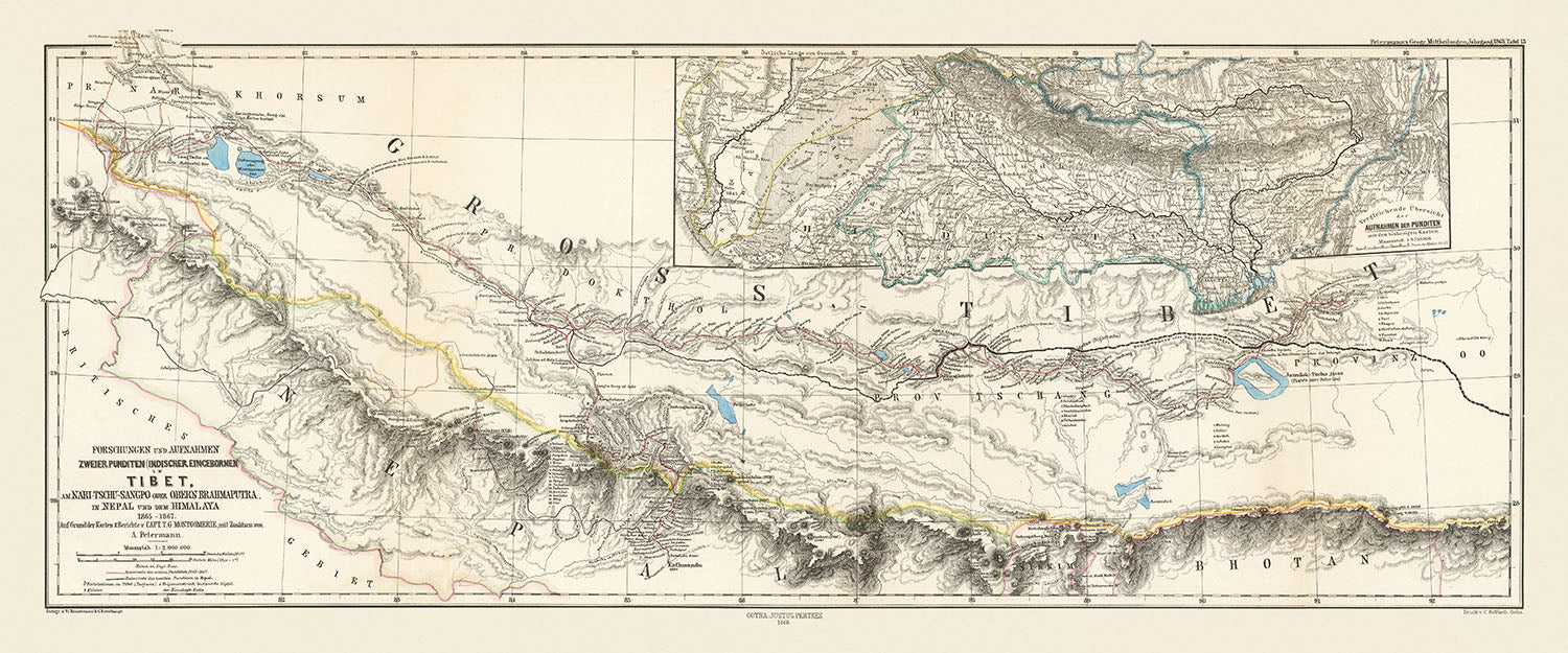
Step into the rich tapestry of history with this exquisite map, "Forschungen und Aufnahmen Zweier Punditen (Indischer Eincebornen) In Tibet, Am Nari-Tschu-Sangpo...
Continue readingStep into the rich tapestry of history with this exquisite map, "Forschungen und Aufnahmen Zweier Punditen (Indischer Eincebornen) In Tibet, Am Nari-Tschu-Sangpo Oder Obern Brahmaputra, In Nepal Und Dem Himalaya 1865-1867," crafted by the renowned cartographer Augustus Herman Petermann in 1868. This hand-colored lithographed map offers a detailed glimpse into the Roof of the World, including the Sikkim-Bhutan-Tibet Tri-border Region. Created just three years after Mount Everest was named by the British Royal Geographical Society, this map is a testament to the meticulous surveying efforts of the 19th century, capturing the essence of a region that has long fascinated explorers and scholars alike.
One of the most compelling aspects of this map is its depiction of the Sikkim-Tibet border, which was later formalized in the 1890 Convention of Calcutta. The map provides several landmarks that were crucial in establishing this boundary, a topic that continues to have geopolitical implications for China and India today. The intricate details and annotations offer a window into the complex territorial claims and the historical context of the late 19th century, making it a valuable piece for anyone interested in the geopolitical history of the region.
The map also highlights the pioneering work of Capt. T. G. Montgomerie, a British surveyor who played a significant role in the Great Trigonometric Survey of India. Montgomerie was responsible for labeling K2, the second highest mountain in the world, and his contributions are evident in the accurate elevations and detailed topographical features depicted on this map. Despite the challenges of surveying in such a remote and often inaccessible region, the work carried out by Montgomerie and his team has stood the test of time, with their calculated elevations closely matching those accepted today.
Beyond its historical and geopolitical significance, this map is a visual delight, showcasing the natural beauty and rugged terrain of the Himalayan region. From the majestic peaks of the Himalayas and the Karakoram range to the winding courses of the Nari-Tschu-Sangpo (Upper Brahmaputra) and other major rivers, the map captures the diverse landscapes that define this part of the world. The hand-colored regions and detailed annotations add an artistic touch, making it not just a map but a piece of art that tells a story of exploration and discovery.
For collectors and history enthusiasts, this map is more than just a navigational tool; it is a piece of history that encapsulates the spirit of 19th-century exploration and the enduring quest to understand our world. Whether displayed in a study, library, or gallery, it serves as a constant reminder of the human drive to explore, map, and ultimately connect with the farthest reaches of our planet. This map is a rare find, offering both aesthetic appeal and a deep historical narrative that will enrich any collection.
Places on this map
- Mount Everest
- Sikkim
- Bhutan
- Tibet
- Nepal
- Almora
- Nari-Tschu-Sangpo (Upper Brahmaputra)
- Ganges Watershed
- Indus Watershed
- Lhasa
- Kathmandu
- Darjeeling
- Simla
- Leh
- Chumbi Valley
- Nyang Chu River
- Manasarovar Lake
- Rangpur
- Gorakhpur
Notable Features & Landmarks
- Mount Everest: Located and labeled on the map.
- Sikkim-Bhutan-Tibet Tri-border Region: Detailed depiction.
- Nari-Tschu-Sangpo (Upper Brahmaputra): River system shown.
- Ganges Watershed: Shown in the inset map.
- Indus Watershed: Shown in the inset map.
- Sikkim-Tibet Border: Detailed landmarks for establishing the border.
- Major summits: Various peaks in the Himalayas.
- Topographical features: Detailed depiction of mountains, rivers, and valleys.
- Routes and trails: Surveyed paths and trails.
- Hand-colored regions: Differentiating various territories.
- Inset map: Provides a larger overview of the region.
- Surveyor routes: Paths taken by the Indian pundits.
- Geographical names: Various locations and features labeled.
- Mountain ranges: Detailed depiction of the Himalayan and Karakoram ranges.
- Rivers: Several major rivers and their tributaries.
- Lakes: Notable lakes in the region.
- Historical survey lines: Routes taken by surveyors.
- Elevation data: Information on the elevations of major summits.
- Cultural landmarks: Important cultural sites in the region.
- Administrative boundaries: Borders between different regions.
- Geopolitical annotations: Notes on territorial claims and boundaries.
- Natural features: Detailed depiction of natural landscapes.
- Surveyor notes: Annotations from the survey work.
Historical and design context
- Name of the map: Forschungen und Aufnahmen Zweier Punditen (Indischer Eincebornen) In Tibet, Am Nari-Tschu-Sangpo Oder Obern Brahmaputra, In Nepal Und Dem Himalaya 1865-1867
- Mapmaker/Publisher: Augustus Herman Petermann, 1868
- Context about the mapmaker: Augustus Herman Petermann was a notable cartographer in the 19th century. His work includes detailed maps of various regions, contributing significantly to geographical knowledge.
- Date of creation: 1868
- Historical significance:
- The map includes the Sikkim-Bhutan-Tibet Tri-border Region.
- It locates Mount Everest, named only three years prior by the British Royal Geographical Society.
- It provides landmarks for the Sikkim-Tibet border, which was formalized in the 1890 Convention of Calcutta.
- The map reflects the geopolitical implications of late-19th-century territorial claims between China and India today.
- Notable individuals:
- Capt. T. G. Montgomerie: British surveyor involved in the Great Trigonometric Survey of India, labeled K2.
- Themes and topics:
- Geopolitical boundaries: Shows the Sikkim-Bhutan-Tibet Tri-border Region.
- Topography: Detailed physical features of the Himalayan region.
- Surveying history: Reflects the work of Indian pundits trained by British surveyors to map Tibet.
- Design/Style:
- Hand-colored lithographed map.
- Detailed physical features and landmarks.
- Inset map showing the Ganges and Indus watersheds.
- Countries and regions shown:
- Tibet
- Nepal
- Bhutan
- India (including the eastern border of Bhutan and Almora)
Please double check the images to make sure that a specific town or place is shown on this map. You can also get in touch and ask us to check the map for you.
This map looks great at every size, but I always recommend going for a larger size if you have space. That way you can easily make out all of the details.
This map looks amazing at sizes all the way up to 50in (125cm). If you are looking for a larger map, please get in touch.
Please note: the labels on this map are hard to read if you order a map that is 16in (40cm) or smaller. The map is still very attractive, but if you would like to read the map easily, please buy a larger size.
This map is wider than most maps, which would make it a perfect statement piece above a mantelpiece, sofa or desk.
The fifth listing image shows an example of my map personalisation service.
If you’re looking for something slightly different, check out my collection of the best old maps to see if something else catches your eye.
Please contact me to check if a certain location, landmark or feature is shown on this map.
This would make a wonderful birthday, Christmas, Father's Day, work leaving, anniversary or housewarming gift for someone from the areas covered by this map.
This map is available as a giclée print on acid free archival matte paper, or you can buy it framed. The frame is a nice, simple black frame that suits most aesthetics. Please get in touch if you'd like a different frame colour or material. My frames are glazed with super-clear museum-grade acrylic (perspex/acrylite), which is significantly less reflective than glass, safer, and will always arrive in perfect condition.
This map is also available as a float framed canvas, sometimes known as a shadow gap framed canvas or canvas floater. The map is printed on artist's cotton canvas and then stretched over a handmade box frame. We then "float" the canvas inside a wooden frame, which is available in a range of colours (black, dark brown, oak, antique gold and white). This is a wonderful way to present a map without glazing in front. See some examples of float framed canvas maps and explore the differences between my different finishes.
For something truly unique, this map is also available in "Unique 3D", our trademarked process that dramatically transforms the map so that it has a wonderful sense of depth. We combine the original map with detailed topography and elevation data, so that mountains and the terrain really "pop". For more info and examples of 3D maps, check my Unique 3D page.
Step into the rich tapestry of history with this exquisite map, "Forschungen und Aufnahmen Zweier Punditen (Indischer Eincebornen) In Tibet, Am Nari-Tschu-Sangpo Oder Obern Brahmaputra, In Nepal Und Dem Himalaya 1865-1867," crafted by the renowned cartographer Augustus Herman Petermann in 1868. This hand-colored lithographed map offers a detailed glimpse into the Roof of the World, including the Sikkim-Bhutan-Tibet Tri-border Region. Created just three years after Mount Everest was named by the British Royal Geographical Society, this map is a testament to the meticulous surveying efforts of the 19th century, capturing the essence of a region that has long fascinated explorers and scholars alike.
One of the most compelling aspects of this map is its depiction of the Sikkim-Tibet border, which was later formalized in the 1890 Convention of Calcutta. The map provides several landmarks that were crucial in establishing this boundary, a topic that continues to have geopolitical implications for China and India today. The intricate details and annotations offer a window into the complex territorial claims and the historical context of the late 19th century, making it a valuable piece for anyone interested in the geopolitical history of the region.
The map also highlights the pioneering work of Capt. T. G. Montgomerie, a British surveyor who played a significant role in the Great Trigonometric Survey of India. Montgomerie was responsible for labeling K2, the second highest mountain in the world, and his contributions are evident in the accurate elevations and detailed topographical features depicted on this map. Despite the challenges of surveying in such a remote and often inaccessible region, the work carried out by Montgomerie and his team has stood the test of time, with their calculated elevations closely matching those accepted today.
Beyond its historical and geopolitical significance, this map is a visual delight, showcasing the natural beauty and rugged terrain of the Himalayan region. From the majestic peaks of the Himalayas and the Karakoram range to the winding courses of the Nari-Tschu-Sangpo (Upper Brahmaputra) and other major rivers, the map captures the diverse landscapes that define this part of the world. The hand-colored regions and detailed annotations add an artistic touch, making it not just a map but a piece of art that tells a story of exploration and discovery.
For collectors and history enthusiasts, this map is more than just a navigational tool; it is a piece of history that encapsulates the spirit of 19th-century exploration and the enduring quest to understand our world. Whether displayed in a study, library, or gallery, it serves as a constant reminder of the human drive to explore, map, and ultimately connect with the farthest reaches of our planet. This map is a rare find, offering both aesthetic appeal and a deep historical narrative that will enrich any collection.
Places on this map
- Mount Everest
- Sikkim
- Bhutan
- Tibet
- Nepal
- Almora
- Nari-Tschu-Sangpo (Upper Brahmaputra)
- Ganges Watershed
- Indus Watershed
- Lhasa
- Kathmandu
- Darjeeling
- Simla
- Leh
- Chumbi Valley
- Nyang Chu River
- Manasarovar Lake
- Rangpur
- Gorakhpur
Notable Features & Landmarks
- Mount Everest: Located and labeled on the map.
- Sikkim-Bhutan-Tibet Tri-border Region: Detailed depiction.
- Nari-Tschu-Sangpo (Upper Brahmaputra): River system shown.
- Ganges Watershed: Shown in the inset map.
- Indus Watershed: Shown in the inset map.
- Sikkim-Tibet Border: Detailed landmarks for establishing the border.
- Major summits: Various peaks in the Himalayas.
- Topographical features: Detailed depiction of mountains, rivers, and valleys.
- Routes and trails: Surveyed paths and trails.
- Hand-colored regions: Differentiating various territories.
- Inset map: Provides a larger overview of the region.
- Surveyor routes: Paths taken by the Indian pundits.
- Geographical names: Various locations and features labeled.
- Mountain ranges: Detailed depiction of the Himalayan and Karakoram ranges.
- Rivers: Several major rivers and their tributaries.
- Lakes: Notable lakes in the region.
- Historical survey lines: Routes taken by surveyors.
- Elevation data: Information on the elevations of major summits.
- Cultural landmarks: Important cultural sites in the region.
- Administrative boundaries: Borders between different regions.
- Geopolitical annotations: Notes on territorial claims and boundaries.
- Natural features: Detailed depiction of natural landscapes.
- Surveyor notes: Annotations from the survey work.
Historical and design context
- Name of the map: Forschungen und Aufnahmen Zweier Punditen (Indischer Eincebornen) In Tibet, Am Nari-Tschu-Sangpo Oder Obern Brahmaputra, In Nepal Und Dem Himalaya 1865-1867
- Mapmaker/Publisher: Augustus Herman Petermann, 1868
- Context about the mapmaker: Augustus Herman Petermann was a notable cartographer in the 19th century. His work includes detailed maps of various regions, contributing significantly to geographical knowledge.
- Date of creation: 1868
- Historical significance:
- The map includes the Sikkim-Bhutan-Tibet Tri-border Region.
- It locates Mount Everest, named only three years prior by the British Royal Geographical Society.
- It provides landmarks for the Sikkim-Tibet border, which was formalized in the 1890 Convention of Calcutta.
- The map reflects the geopolitical implications of late-19th-century territorial claims between China and India today.
- Notable individuals:
- Capt. T. G. Montgomerie: British surveyor involved in the Great Trigonometric Survey of India, labeled K2.
- Themes and topics:
- Geopolitical boundaries: Shows the Sikkim-Bhutan-Tibet Tri-border Region.
- Topography: Detailed physical features of the Himalayan region.
- Surveying history: Reflects the work of Indian pundits trained by British surveyors to map Tibet.
- Design/Style:
- Hand-colored lithographed map.
- Detailed physical features and landmarks.
- Inset map showing the Ganges and Indus watersheds.
- Countries and regions shown:
- Tibet
- Nepal
- Bhutan
- India (including the eastern border of Bhutan and Almora)
Please double check the images to make sure that a specific town or place is shown on this map. You can also get in touch and ask us to check the map for you.
This map looks great at every size, but I always recommend going for a larger size if you have space. That way you can easily make out all of the details.
This map looks amazing at sizes all the way up to 50in (125cm). If you are looking for a larger map, please get in touch.
Please note: the labels on this map are hard to read if you order a map that is 16in (40cm) or smaller. The map is still very attractive, but if you would like to read the map easily, please buy a larger size.
This map is wider than most maps, which would make it a perfect statement piece above a mantelpiece, sofa or desk.
The fifth listing image shows an example of my map personalisation service.
If you’re looking for something slightly different, check out my collection of the best old maps to see if something else catches your eye.
Please contact me to check if a certain location, landmark or feature is shown on this map.
This would make a wonderful birthday, Christmas, Father's Day, work leaving, anniversary or housewarming gift for someone from the areas covered by this map.
This map is available as a giclée print on acid free archival matte paper, or you can buy it framed. The frame is a nice, simple black frame that suits most aesthetics. Please get in touch if you'd like a different frame colour or material. My frames are glazed with super-clear museum-grade acrylic (perspex/acrylite), which is significantly less reflective than glass, safer, and will always arrive in perfect condition.
This map is also available as a float framed canvas, sometimes known as a shadow gap framed canvas or canvas floater. The map is printed on artist's cotton canvas and then stretched over a handmade box frame. We then "float" the canvas inside a wooden frame, which is available in a range of colours (black, dark brown, oak, antique gold and white). This is a wonderful way to present a map without glazing in front. See some examples of float framed canvas maps and explore the differences between my different finishes.
For something truly unique, this map is also available in "Unique 3D", our trademarked process that dramatically transforms the map so that it has a wonderful sense of depth. We combine the original map with detailed topography and elevation data, so that mountains and the terrain really "pop". For more info and examples of 3D maps, check my Unique 3D page.
Many of our maps and art prints are chosen as thoughtful gifts for homes, offices, studies and meaningful places.
Choose a framed option for the easiest ready-to-hang gift, or choose an unframed print if the recipient may prefer to select their own frame.
We make orders locally in 23 countries around the world, so gifts can often be produced close to the recipient. This helps them arrive faster, travel more safely, and avoid customs or import duty surprises.
- We can deliver directly to the recipient
- Framed pieces arrive ready to hang
- Unframed prints are carefully packed in a strong protective tube
- Almost every order is made locally, for faster, safer gifting
- 90-day returns give the recipient time to decide
If you are not sure what to choose, please contact us. We can help you pick the right map, size, finish or delivery option.
Most orders are made locally and delivered in around 2–3 working days, depending on the product, size and destination.
We print and frame maps and artwork in 23 countries around the world, so your order is usually made close to you or your recipient. That means faster delivery, less time in transit, and no customs or import duty surprises.
Personalised and customised pieces usually take an extra 1–2 working days, because we prepare your design and send it to you for approval before printing.
Very large framed orders can take a little longer, as they need extra care in production and delivery.
Every order is carefully packaged: unframed prints are sent in a strong protective tube, while framed pieces are securely packed with protective materials around the frame.
If you need your order by a particular date, please contact us before ordering. We’ll check the best production route and delivery option for your location.
Express delivery is available at checkout for most countries. Next-day delivery is available in the UK, US, Singapore and the UAE.
Your order is covered by our 90-day returns policy and 10-year guarantee.
Our standard frame is a gallery-style black ash hardwood frame, with a simple, modern look. It is approximately 20mm (0.8in) wide. You can also view some lovely customer photos of framed maps and art.
We use super-clear acrylic glazing, also known as Perspex or Acrylite, instead of traditional glass. It is lighter, safer, and has lower reflectivity, giving the artwork a clearer, cleaner appearance.
Six standard frame colours are available at no extra cost: black, dark brown, dark grey, oak, white, and antique gold. Custom framing and mounting/matting is also available for customers looking for something more specific.
Most maps, art prints, and illustrations are also available as a framed canvas. We use matte cotton canvas, stretch it over a sustainably sourced wooden box frame, and then float the piece within a wooden outer frame. The finished result is beautifully presented, with no glazing between you and the artwork.
All frames are supplied ready to hang, with either string or brackets fitted to the back. Very large frames will include heavy-duty hanging plates and/or a mounting baton. If you have any questions, please get in touch.
We can also supply old maps and artwork on canvas, foam board, cotton rag, and other materials.
If you would prefer to frame your map or artwork yourself, please read our size guide before ordering.
My maps are extremely high quality reproductions of original maps.
I source original, rare maps from libraries, auction houses and private collections around the world, restore them at my London workshop, and then use specialist giclée inks and printers to create beautiful maps that look even better than the original.
My maps are printed on acid-free archival matte (not glossy) paper that feels very high quality and almost like card. In technical terms the paper weight/thickness is 10mil/200gsm. It's perfect for framing.
I print with Epson ultrachrome giclée UV fade resistant pigment inks - some of the best inks you can find.
I can also make maps on canvas, cotton rag and other exotic materials.
Learn more about The Unique Maps Co.
Map personalisation
If you're looking for the perfect anniversary or housewarming gift, I can personalise your map to make it truly unique. For example, I can add a short message, or highlight an important location, or add your family's coat of arms.
The options are almost infinite. Please see my map personalisation page for some wonderful examples of what's possible.
To order a personalised map, select "personalise your map" before adding it to your basket.
Get in touch if you're looking for more complex customisations and personalisations.
Map ageing
I have been asked hundreds of times over the years by customers if they could buy a map that looks even older.
Well, now you can, by selecting Aged before you add a map to your basket.
All the product photos you see on this page show the map in its Original form. This is what the map looks like today.
If you select Aged, I will age your map by hand, using a special and unique process developed through years of studying old maps, talking to researchers to understand the chemistry of aging paper, and of course... lots of practice!
If you're unsure, stick to the Original colour of the map. If you want something a bit darker and older looking, go for Aged.
If you are not happy with your order for any reason, contact me and I'll get it fixed ASAP, free of charge. Please see my returns and refund policy for more information.
I am very confident you will like your restored map or art print. I have been doing this since 1984. I'm a 5-star Etsy seller. I have sold tens of thousands of maps and art prints and have over 5,000 real 5-star reviews. My work has been featured in interior design magazines, on the BBC, and on the walls of dozens of 5-star hotels.
I use a unique process to restore maps and artwork that is massively time consuming and labour intensive. Hunting down the original maps and illustrations can take months. I use state of the art and eye-wateringly expensive technology to scan and restore them. As a result, I guarantee my maps and art prints are a cut above the rest. I stand by my products and will always make sure you're 100% happy with what you receive.
Almost all of my maps and art prints look amazing at large sizes (200cm, 6.5ft+) and I can frame and deliver them to you as well, via special oversized courier. Contact me to discuss your specific needs.
Or try searching for something!


