


Rare Old Nautical World Map by Heather, 1828: East India Company Nautical Pricking Chart
The Collector’s Offer
Choose two eligible works and receive 20% off both. Choose three and the lowest-priced one is complimentary, a maximum saving of 33%.
Mix and match eligible standard maps and fine-art prints. No code is required; the offer is applied automatically at checkout.
Standard made-to-order configurations are included. Bespoke sizes, personalised designs and commissioned work are excluded.
Need delivery to different addresses? Contact us before ordering.The Collector’s Offer
Choose two eligible works and receive 20% off both. Choose three and the lowest-priced one is complimentary, a maximum saving of 33%.
Mix and match eligible standard maps and fine-art prints. No code is required; the offer is applied automatically at checkout.
Standard made-to-order configurations are included. Bespoke sizes, personalised designs and commissioned work are excluded.
Need delivery to different addresses? Contact us before ordering. Designed in London Made in Australia
Designed in London • Made in Australia
Designed in London Made in Australia
Designed in London • Made in Australia

Restored from the original 1830 map and printed to museum-grade archival standards. Read the story behind this map
Choose your size
Choose your finish


(More info)
Gift message & custom finish

If you want to add a gift message, or a finish (jigsaw, aluminium board, etc.) that is not available here, please request it in the "order note" when you check out.
Every order is custom made, so if you need the size adjusted slightly, or printed on an unusual material, just let us know. We've done thousands of custom orders over the years, so there's (almost) nothing we can't manage.
You can also contact us before you order, if you prefer!

- Made locally for fast, safe delivery
- No import duty or hidden fees
- Need advice? Call us or message on WhatsApp
Own a piece of history
8,000+ five-star reviews


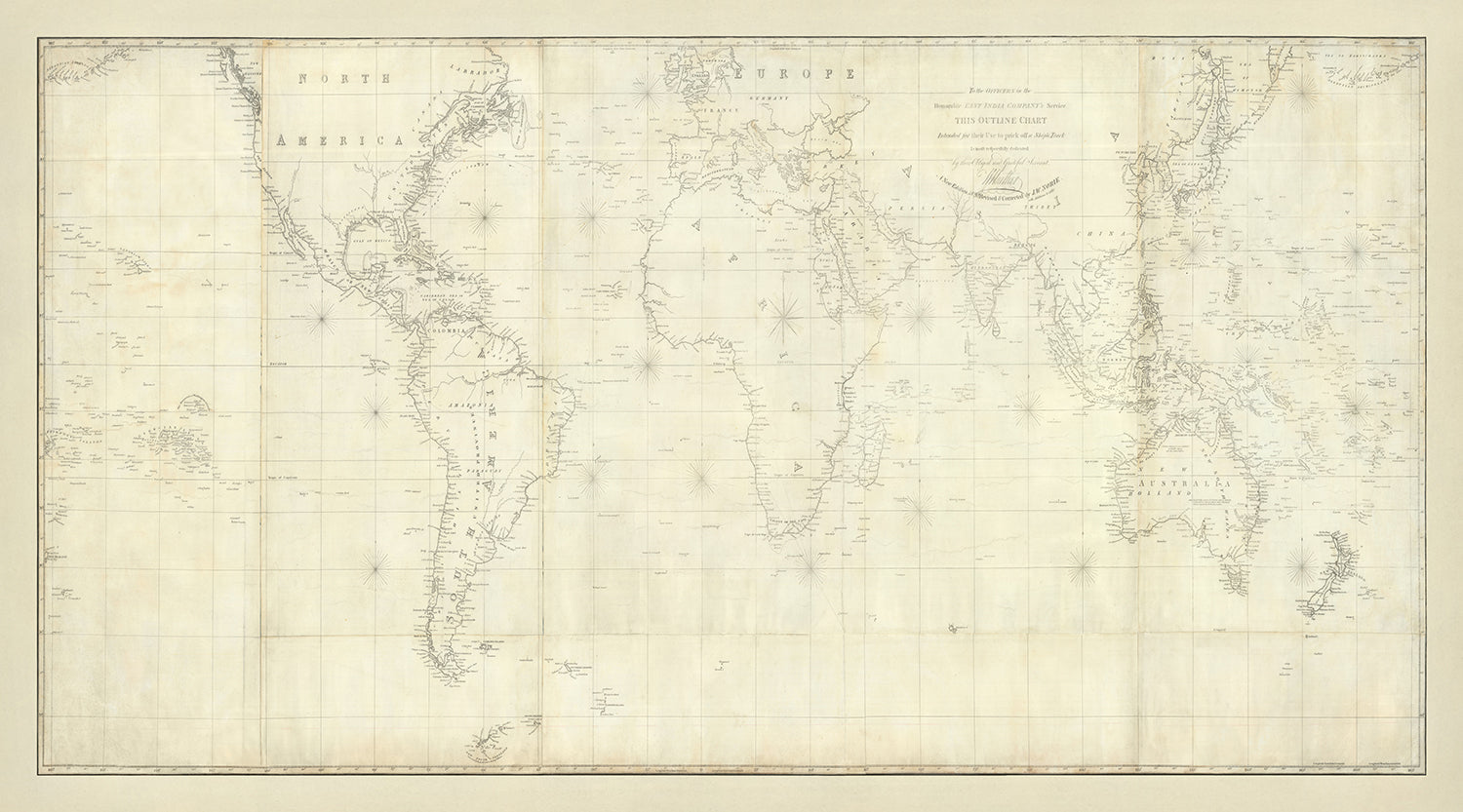
This exquisite nautical chart, "To the Officers in the Honorable East India Company's Service This Outline Chart Intended for their Use to...
Continue readingThis exquisite nautical chart, "To the Officers in the Honorable East India Company's Service This Outline Chart Intended for their Use to prick-off a Ship's Track," is a remarkable artifact from the early 19th century, created by the renowned mapmaker William Heather. Originally printed in the 1810s and meticulously updated through 1830, this map offers a fascinating glimpse into the navigational practices of the time. Its primary function was to aid mariners in dead reckoning, a method of estimating a ship's position by marking its course and distance traveled from a known point. This chart is not only a tool for navigation but also a testament to the skill and precision of early cartographers.
The map's main topics revolve around nautical navigation and the tracking of maritime voyages. It showcases the routes between the coast of France, Marie Galante in the Caribbean, and Rio De Janeiro, reflecting the global reach of maritime exploration and trade during this period. The use of the Mercator Projection, favored for its ability to represent lines of constant course, highlights the map's practical application for sailors. This projection, combined with the detailed pricking marks, allowed mariners to plot their courses with remarkable accuracy, ensuring safer and more efficient voyages.
William Heather's expertise in creating navigational aids is evident in the map's intricate design. The chart includes various navigational aids such as compass roses, soundings (water depths in fathoms), and water channels, all essential for safe navigation. The presence of these features underscores the map's role as a comprehensive tool for mariners, providing them with the information needed to navigate the world's oceans. Heather's maps were highly regarded for their accuracy and attention to detail, making them invaluable resources for sailors of the time.
The geographical scope of the map is truly impressive, covering the entire world and highlighting major continents and oceans. It focuses on coastal regions, marking towns, harbors, and other navigational landmarks that were crucial for maritime navigation. The map also depicts various islands, particularly in the Caribbean and Pacific regions, along with common maritime routes. This extensive coverage not only reflects the state of geographical knowledge in the early 19th century but also the global nature of maritime exploration and trade.
The historical significance of this map cannot be overstated. As a rare survival from before 1840, it offers a unique window into the navigational techniques and maritime routes of the time. The map's association with the Honorable East India Company further enhances its historical value, as it was used by officers in one of the most influential trading companies of the era. This chart is not just a navigational tool but a piece of history, capturing the spirit of exploration and the advancements in cartography that defined the early 19th century.
Notable places on this map:
- North America: Coastal regions and major ports.
- South America: Coastal areas, particularly around Rio De Janeiro.
- Europe: Coastal regions, including major ports in France and the UK.
- Africa: Coastal areas and ports along the continent.
- Asia: Coastal regions, including parts of India and Southeast Asia.
- Australia (New Holland): Coastal regions and major landmarks.
- Caribbean: Islands such as Marie Galante.
- New Zealand: Coastal regions and notable landmarks.
- Atlantic Ocean: Various islands and navigational routes.
- Indian Ocean: Coastal features and maritime routes.
Notable Features & Landmarks:
- Geographical area: The map covers the entire world, showing major continents and oceans.
- Navigational aids: Includes compass roses and likely soundings (water depths in fathoms).
- Voyage tracks: Shows tracks of voyages, particularly between France, Marie Galante in the Caribbean, and Rio De Janeiro.
- Coastal features: Focuses on coastal towns, harbors, and other navigational landmarks.
- Mercator Projection: Used for accurate representation of navigational courses.
- Islands: Various islands are labeled and shown, particularly in the Caribbean and Pacific regions.
- Currents and water channels: Likely marked to aid in navigation.
- Maritime routes: Indicates common maritime routes used during the period.
- Historical context: Reflects the state of geographical knowledge and navigational techniques in the early 19th century.
- East India Company: Contextualizes the map's use by officers in the Honorable East India Company's service.
Historical and design context:
- Name of the map: "To the Officers in the Honorable East India Company's Service This Outline Chart Intended for their Use to prick-off a Ship's Track"
- Date created: Originally printed in the 1810s, updated in 1820, and later revised and corrected to 1830.
- Mapmaker/Publisher: William Heather
- Context about the mapmaker: William Heather was known for creating nautical charts and navigational aids during the 19th century.
- Topics and themes shown on the map:
- Nautical navigation: The map is used for pricking-off a ship's track, a method of dead reckoning to estimate a ship's position.
- Voyages: Tracks of voyages between the coast of France, Marie Galante in the Caribbean, and Rio De Janeiro.
- Mercator Projection: Preferred for tracking voyages at sea.
- Design or style of the map:
- Mercator Projection: This projection is useful for nautical navigation as it represents lines of constant course.
- Pricking marks: Used for dead reckoning, allowing mariners to mark their estimated position.
- Navigational aids: Likely includes soundings, compass roses, and water channels.
- Historical significance or context:
- Navigational aid: The map represents an important tool for mariners in the 19th century.
- Rare survival: Complete pricking maps from before 1830 are rare, making this a significant historical artifact.
- Dead reckoning: Demonstrates the navigational techniques used before the widespread adoption of more advanced methods.
Please double check the images to make sure that a specific town or place is shown on this map. You can also get in touch and ask us to check the map for you.
This map looks great at every size, but I always recommend going for a larger size if you have space. That way you can easily make out all of the details.
This map looks amazing at sizes all the way up to 50in (125cm). If you are looking for a larger map, please get in touch.
The model in the listing images is holding the 16x20in (40x50cm) version of this map.
The fifth listing image shows an example of my map personalisation service.
If you’re looking for something slightly different, check out my collection of the best old maps to see if something else catches your eye.
Please contact me to check if a certain location, landmark or feature is shown on this map.
This would make a wonderful birthday, Christmas, Father's Day, work leaving, anniversary or housewarming gift for someone from the areas covered by this map.
This map is available as a giclée print on acid free archival matte paper, or you can buy it framed. The frame is a nice, simple black frame that suits most aesthetics. Please get in touch if you'd like a different frame colour or material. My frames are glazed with super-clear museum-grade acrylic (perspex/acrylite), which is significantly less reflective than glass, safer, and will always arrive in perfect condition.
This map is also available as a float framed canvas, sometimes known as a shadow gap framed canvas or canvas floater. The map is printed on artist's cotton canvas and then stretched over a handmade box frame. We then "float" the canvas inside a wooden frame, which is available in a range of colours (black, dark brown, oak, antique gold and white). This is a wonderful way to present a map without glazing in front. See some examples of float framed canvas maps and explore the differences between my different finishes.
For something truly unique, this map is also available in "Unique 3D", our trademarked process that dramatically transforms the map so that it has a wonderful sense of depth. We combine the original map with detailed topography and elevation data, so that mountains and the terrain really "pop". For more info and examples of 3D maps, check my Unique 3D page.
This exquisite nautical chart, "To the Officers in the Honorable East India Company's Service This Outline Chart Intended for their Use to prick-off a Ship's Track," is a remarkable artifact from the early 19th century, created by the renowned mapmaker William Heather. Originally printed in the 1810s and meticulously updated through 1830, this map offers a fascinating glimpse into the navigational practices of the time. Its primary function was to aid mariners in dead reckoning, a method of estimating a ship's position by marking its course and distance traveled from a known point. This chart is not only a tool for navigation but also a testament to the skill and precision of early cartographers.
The map's main topics revolve around nautical navigation and the tracking of maritime voyages. It showcases the routes between the coast of France, Marie Galante in the Caribbean, and Rio De Janeiro, reflecting the global reach of maritime exploration and trade during this period. The use of the Mercator Projection, favored for its ability to represent lines of constant course, highlights the map's practical application for sailors. This projection, combined with the detailed pricking marks, allowed mariners to plot their courses with remarkable accuracy, ensuring safer and more efficient voyages.
William Heather's expertise in creating navigational aids is evident in the map's intricate design. The chart includes various navigational aids such as compass roses, soundings (water depths in fathoms), and water channels, all essential for safe navigation. The presence of these features underscores the map's role as a comprehensive tool for mariners, providing them with the information needed to navigate the world's oceans. Heather's maps were highly regarded for their accuracy and attention to detail, making them invaluable resources for sailors of the time.
The geographical scope of the map is truly impressive, covering the entire world and highlighting major continents and oceans. It focuses on coastal regions, marking towns, harbors, and other navigational landmarks that were crucial for maritime navigation. The map also depicts various islands, particularly in the Caribbean and Pacific regions, along with common maritime routes. This extensive coverage not only reflects the state of geographical knowledge in the early 19th century but also the global nature of maritime exploration and trade.
The historical significance of this map cannot be overstated. As a rare survival from before 1840, it offers a unique window into the navigational techniques and maritime routes of the time. The map's association with the Honorable East India Company further enhances its historical value, as it was used by officers in one of the most influential trading companies of the era. This chart is not just a navigational tool but a piece of history, capturing the spirit of exploration and the advancements in cartography that defined the early 19th century.
Notable places on this map:
- North America: Coastal regions and major ports.
- South America: Coastal areas, particularly around Rio De Janeiro.
- Europe: Coastal regions, including major ports in France and the UK.
- Africa: Coastal areas and ports along the continent.
- Asia: Coastal regions, including parts of India and Southeast Asia.
- Australia (New Holland): Coastal regions and major landmarks.
- Caribbean: Islands such as Marie Galante.
- New Zealand: Coastal regions and notable landmarks.
- Atlantic Ocean: Various islands and navigational routes.
- Indian Ocean: Coastal features and maritime routes.
Notable Features & Landmarks:
- Geographical area: The map covers the entire world, showing major continents and oceans.
- Navigational aids: Includes compass roses and likely soundings (water depths in fathoms).
- Voyage tracks: Shows tracks of voyages, particularly between France, Marie Galante in the Caribbean, and Rio De Janeiro.
- Coastal features: Focuses on coastal towns, harbors, and other navigational landmarks.
- Mercator Projection: Used for accurate representation of navigational courses.
- Islands: Various islands are labeled and shown, particularly in the Caribbean and Pacific regions.
- Currents and water channels: Likely marked to aid in navigation.
- Maritime routes: Indicates common maritime routes used during the period.
- Historical context: Reflects the state of geographical knowledge and navigational techniques in the early 19th century.
- East India Company: Contextualizes the map's use by officers in the Honorable East India Company's service.
Historical and design context:
- Name of the map: "To the Officers in the Honorable East India Company's Service This Outline Chart Intended for their Use to prick-off a Ship's Track"
- Date created: Originally printed in the 1810s, updated in 1820, and later revised and corrected to 1830.
- Mapmaker/Publisher: William Heather
- Context about the mapmaker: William Heather was known for creating nautical charts and navigational aids during the 19th century.
- Topics and themes shown on the map:
- Nautical navigation: The map is used for pricking-off a ship's track, a method of dead reckoning to estimate a ship's position.
- Voyages: Tracks of voyages between the coast of France, Marie Galante in the Caribbean, and Rio De Janeiro.
- Mercator Projection: Preferred for tracking voyages at sea.
- Design or style of the map:
- Mercator Projection: This projection is useful for nautical navigation as it represents lines of constant course.
- Pricking marks: Used for dead reckoning, allowing mariners to mark their estimated position.
- Navigational aids: Likely includes soundings, compass roses, and water channels.
- Historical significance or context:
- Navigational aid: The map represents an important tool for mariners in the 19th century.
- Rare survival: Complete pricking maps from before 1830 are rare, making this a significant historical artifact.
- Dead reckoning: Demonstrates the navigational techniques used before the widespread adoption of more advanced methods.
Please double check the images to make sure that a specific town or place is shown on this map. You can also get in touch and ask us to check the map for you.
This map looks great at every size, but I always recommend going for a larger size if you have space. That way you can easily make out all of the details.
This map looks amazing at sizes all the way up to 50in (125cm). If you are looking for a larger map, please get in touch.
The model in the listing images is holding the 16x20in (40x50cm) version of this map.
The fifth listing image shows an example of my map personalisation service.
If you’re looking for something slightly different, check out my collection of the best old maps to see if something else catches your eye.
Please contact me to check if a certain location, landmark or feature is shown on this map.
This would make a wonderful birthday, Christmas, Father's Day, work leaving, anniversary or housewarming gift for someone from the areas covered by this map.
This map is available as a giclée print on acid free archival matte paper, or you can buy it framed. The frame is a nice, simple black frame that suits most aesthetics. Please get in touch if you'd like a different frame colour or material. My frames are glazed with super-clear museum-grade acrylic (perspex/acrylite), which is significantly less reflective than glass, safer, and will always arrive in perfect condition.
This map is also available as a float framed canvas, sometimes known as a shadow gap framed canvas or canvas floater. The map is printed on artist's cotton canvas and then stretched over a handmade box frame. We then "float" the canvas inside a wooden frame, which is available in a range of colours (black, dark brown, oak, antique gold and white). This is a wonderful way to present a map without glazing in front. See some examples of float framed canvas maps and explore the differences between my different finishes.
For something truly unique, this map is also available in "Unique 3D", our trademarked process that dramatically transforms the map so that it has a wonderful sense of depth. We combine the original map with detailed topography and elevation data, so that mountains and the terrain really "pop". For more info and examples of 3D maps, check my Unique 3D page.
Many of our maps and art prints are chosen as thoughtful gifts for homes, offices, studies and meaningful places.
Choose a framed option for the easiest ready-to-hang gift, or choose an unframed print if the recipient may prefer to select their own frame.
We make orders locally in 23 countries around the world, so gifts can often be produced close to the recipient. This helps them arrive faster, travel more safely, and avoid customs or import duty surprises.
- We can deliver directly to the recipient
- Framed pieces arrive ready to hang
- Unframed prints are carefully packed in a strong protective tube
- Almost every order is made locally, for faster, safer gifting
- 90-day returns give the recipient time to decide
If you are not sure what to choose, please contact us. We can help you pick the right map, size, finish or delivery option.
Most orders are made locally and delivered in around 2–3 working days, depending on the product, size and destination.
We print and frame maps and artwork in 23 countries around the world, so your order is usually made close to you or your recipient. That means faster delivery, less time in transit, and no customs or import duty surprises.
Personalised and customised pieces usually take an extra 1–2 working days, because we prepare your design and send it to you for approval before printing.
Very large framed orders can take a little longer, as they need extra care in production and delivery.
Every order is carefully packaged: unframed prints are sent in a strong protective tube, while framed pieces are securely packed with protective materials around the frame.
If you need your order by a particular date, please contact us before ordering. We’ll check the best production route and delivery option for your location.
Express delivery is available at checkout for most countries. Next-day delivery is available in the UK, US, Singapore and the UAE.
Your order is covered by our 90-day returns policy and 10-year guarantee.
Our standard frame is a gallery-style black ash hardwood frame, with a simple, modern look. It is approximately 20mm (0.8in) wide. You can also view some lovely customer photos of framed maps and art.
We use super-clear acrylic glazing, also known as Perspex or Acrylite, instead of traditional glass. It is lighter, safer, and has lower reflectivity, giving the artwork a clearer, cleaner appearance.
Six standard frame colours are available at no extra cost: black, dark brown, dark grey, oak, white, and antique gold. Custom framing and mounting/matting is also available for customers looking for something more specific.
Most maps, art prints, and illustrations are also available as a framed canvas. We use matte cotton canvas, stretch it over a sustainably sourced wooden box frame, and then float the piece within a wooden outer frame. The finished result is beautifully presented, with no glazing between you and the artwork.
All frames are supplied ready to hang, with either string or brackets fitted to the back. Very large frames will include heavy-duty hanging plates and/or a mounting baton. If you have any questions, please get in touch.
We can also supply old maps and artwork on canvas, foam board, cotton rag, and other materials.
If you would prefer to frame your map or artwork yourself, please read our size guide before ordering.
My maps are extremely high quality reproductions of original maps.
I source original, rare maps from libraries, auction houses and private collections around the world, restore them at my London workshop, and then use specialist giclée inks and printers to create beautiful maps that look even better than the original.
My maps are printed on acid-free archival matte (not glossy) paper that feels very high quality and almost like card. In technical terms the paper weight/thickness is 10mil/200gsm. It's perfect for framing.
I print with Epson ultrachrome giclée UV fade resistant pigment inks - some of the best inks you can find.
I can also make maps on canvas, cotton rag and other exotic materials.
Learn more about The Unique Maps Co.
Map personalisation
If you're looking for the perfect anniversary or housewarming gift, I can personalise your map to make it truly unique. For example, I can add a short message, or highlight an important location, or add your family's coat of arms.
The options are almost infinite. Please see my map personalisation page for some wonderful examples of what's possible.
To order a personalised map, select "personalise your map" before adding it to your basket.
Get in touch if you're looking for more complex customisations and personalisations.
Map ageing
I have been asked hundreds of times over the years by customers if they could buy a map that looks even older.
Well, now you can, by selecting Aged before you add a map to your basket.
All the product photos you see on this page show the map in its Original form. This is what the map looks like today.
If you select Aged, I will age your map by hand, using a special and unique process developed through years of studying old maps, talking to researchers to understand the chemistry of aging paper, and of course... lots of practice!
If you're unsure, stick to the Original colour of the map. If you want something a bit darker and older looking, go for Aged.
If you are not happy with your order for any reason, contact me and I'll get it fixed ASAP, free of charge. Please see my returns and refund policy for more information.
I am very confident you will like your restored map or art print. I have been doing this since 1984. I'm a 5-star Etsy seller. I have sold tens of thousands of maps and art prints and have over 5,000 real 5-star reviews. My work has been featured in interior design magazines, on the BBC, and on the walls of dozens of 5-star hotels.
I use a unique process to restore maps and artwork that is massively time consuming and labour intensive. Hunting down the original maps and illustrations can take months. I use state of the art and eye-wateringly expensive technology to scan and restore them. As a result, I guarantee my maps and art prints are a cut above the rest. I stand by my products and will always make sure you're 100% happy with what you receive.
Almost all of my maps and art prints look amazing at large sizes (200cm, 6.5ft+) and I can frame and deliver them to you as well, via special oversized courier. Contact me to discuss your specific needs.
Or try searching for something!


