


Rare Old Pictorial Map of Cambridgeshire by Clegg, 1947: Cambridge, Ely, WWII, King's College, See of Ely
The Collector’s Offer
Choose two eligible works and receive 20% off both. Choose three and the lowest-priced one is complimentary, a maximum saving of 33%.
Mix and match eligible standard maps and fine-art prints. No code is required; the offer is applied automatically at checkout.
Standard made-to-order configurations are included. Bespoke sizes, personalised designs and commissioned work are excluded.
Need delivery to different addresses? Contact us before ordering.The Collector’s Offer
Choose two eligible works and receive 20% off both. Choose three and the lowest-priced one is complimentary, a maximum saving of 33%.
Mix and match eligible standard maps and fine-art prints. No code is required; the offer is applied automatically at checkout.
Standard made-to-order configurations are included. Bespoke sizes, personalised designs and commissioned work are excluded.
Need delivery to different addresses? Contact us before ordering. Restored in London • Made in Australia

Restored from the original 1947 map and printed to museum-grade archival standards. Read the story behind this map
Choose your size
Choose your finish


(More info)
Gift message & custom finish

If you want to add a gift message, or a finish (jigsaw, aluminium board, etc.) that is not available here, please request it in the "order note" when you check out.
Every order is custom made, so if you need the size adjusted slightly, or printed on an unusual material, just let us know. We've done thousands of custom orders over the years, so there's (almost) nothing we can't manage.
You can also contact us before you order, if you prefer!

- Made locally for fast, safe delivery
- No import duty or hidden fees
- Need advice? Call us or message on WhatsApp
Own a piece of history
8,000+ five-star reviews


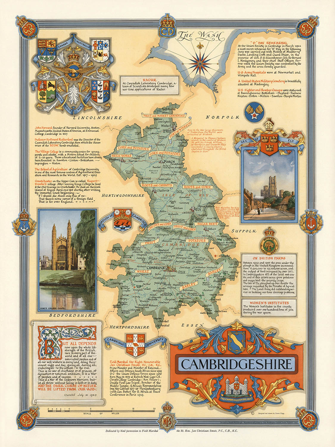
Ernest Clegg's 1947 masterpiece, titled "Cambridgeshire," is a captivating blend of artistry and cartographic precision, embodying the rich historical and cultural tapestry...
Continue readingErnest Clegg's 1947 masterpiece, titled "Cambridgeshire," is a captivating blend of artistry and cartographic precision, embodying the rich historical and cultural tapestry of this iconic English county. This pictorial map is adorned with vignettes of the illustrious King's College Chapel and the majestic See of Ely, drawing the viewer into the heart of Cambridgeshire's storied past. The map's dedication to Field Marshal the Rt. Hon. Jan Christiaan Smuts, a prominent figure in World War II, underscores its significance as a tribute to the allied victory and the resilience of the British spirit.
Clegg, renowned for his meticulous and artistic cartographic works, has infused this map with an array of historical and cultural details. The map features city coats of arms, towns, and rivers, each rendered with exquisite detail. Notes about Cambridge and its famous figures, alongside quotes from Sir Winston Churchill, provide a rich narrative that celebrates the county's contributions to history and academia. This map is not just a geographical representation but a celebration of Cambridgeshire's enduring legacy.
The thematic elements of the map are particularly striking, highlighting both historical and contemporary themes. Agricultural regions are meticulously marked, reflecting the county's rich farming heritage. The map also pays homage to the wartime efforts of British farms and Women's Institutes, capturing the spirit of resilience and community that defined the era. The inclusion of radar development and D-Day rehearsals further emphasizes Cambridgeshire's strategic importance during World War II.
Geographically, the map offers a detailed portrayal of Cambridgeshire and its neighboring counties, including Lincolnshire, Norfolk, Suffolk, Bedfordshire, Hertfordshire, and Essex. The intricate illustrations of the Wash, rivers, and agricultural zones such as fruit and market gardening, potatoes, and sugar beet regions, provide a comprehensive view of the county's landscape. The historical notes about John Harvard, the founder of Harvard University, and other notable figures associated with Cambridge, add layers of depth and context to the map.
Ernest Clegg's "Cambridgeshire" is a testament to the county's historical and cultural significance. The map's design, with its rich decorations, coats of arms, and detailed illustrations, offers a visual feast that is both informative and aesthetically pleasing. It stands as a remarkable piece of cartographic art, celebrating the legacy of Cambridgeshire and its contributions to history, academia, and wartime efforts. This map is a perfect addition for collectors and history enthusiasts who appreciate the intricate blend of art and history.
Cities and towns on this map
- Cambridgeshire:
- Cambridge
- Ely
- Wisbech
- March
- St. Ives
- St. Neots
Notable Features & Landmarks
- King's College Chapel
- See of Ely
- Cambridge University
- Vignettes of historical landmarks
- Coats of arms of various cities
- Quotes by Sir Winston Churchill
- Dedication to Field Marshal Jan Christiaan Smuts
- Notes on British farms
- Notes on Women's Institutes
- WWII references, including D-Day rehearsals and radar development
- Illustrations of the Wash
- Detailed agricultural regions (e.g., fruit and market gardening, potatoes, sugar beet)
- Historical notes about John Harvard, founder of Harvard University
- Illustration of Field Marshal Jan Christiaan Smuts
- Illustrations of radar and its significance
- Illustrations of the allied victory in World War II
- Notes on historical figures associated with Cambridge
Historical and design context
- Name of the map: Cambridgeshire
- Pictorial elements: Includes vignettes of King's College Chapel and the See of Ely.
- Points of interest: Highlights points of interest, city coats of arms, towns, and rivers in high detail.
- Historical notes: Contains notes about Cambridge and famous persons and places in its history.
- WWII celebration: Celebrates the allied victory in World War II.
- Quotes: Features quotes by Sir Winston Churchill from July 14, 1940.
- Dedication: Dedicated by kind permission to Field Marshal the Rt. Hon. Jan Christiaan Smuts, P.C., C.H., K.C.
- Date of creation: 1947
- Mapmaker/publisher: Ernest Clegg
- Context about the mapmaker: Ernest Clegg was known for his detailed and artistic cartographic works, often blending historical and contemporary themes.
- Topics and themes:
- Historical and cultural: Emphasizes historical events, famous persons, and cultural landmarks of Cambridgeshire.
- Agricultural and wartime: Notes on British farms and Women's Institutes, reflecting the wartime context and post-war recovery.
- Countries and regions shown: Primarily focuses on Cambridgeshire, with references to neighboring counties such as Lincolnshire, Norfolk, Suffolk, Bedfordshire, Hertfordshire, and Essex.
- Design and style: The map has a thematic and pictorial design, richly decorated with coats of arms, vignettes, and detailed illustrations.
- Historical significance: The map commemorates the historical and cultural heritage of Cambridgeshire, celebrating its contributions during World War II and the allied victory.
Please double check the images to make sure that a specific town or place is shown on this map. You can also get in touch and ask us to check the map for you.
This map looks great at every size, but I always recommend going for a larger size if you have space. That way you can easily make out all of the details.
This map looks amazing at sizes all the way up to 70in (180cm). If you are looking for a larger map, please get in touch.
The model in the listing images is holding the 18x24in (45x60cm) version of this map.
The fifth listing image shows an example of my map personalisation service.
If you’re looking for something slightly different, check out my collection of the best old maps to see if something else catches your eye.
Please contact me to check if a certain location, landmark or feature is shown on this map.
This would make a wonderful birthday, Christmas, Father's Day, work leaving, anniversary or housewarming gift for someone from the areas covered by this map.
This map is available as a giclée print on acid free archival matte paper, or you can buy it framed. The frame is a nice, simple black frame that suits most aesthetics. Please get in touch if you'd like a different frame colour or material. My frames are glazed with super-clear museum-grade acrylic (perspex/acrylite), which is significantly less reflective than glass, safer, and will always arrive in perfect condition.
This map is also available as a float framed canvas, sometimes known as a shadow gap framed canvas or canvas floater. The map is printed on artist's cotton canvas and then stretched over a handmade box frame. We then "float" the canvas inside a wooden frame, which is available in a range of colours (black, dark brown, oak, antique gold and white). This is a wonderful way to present a map without glazing in front. See some examples of float framed canvas maps and explore the differences between my different finishes.
For something truly unique, this map is also available in "Unique 3D", our trademarked process that dramatically transforms the map so that it has a wonderful sense of depth. We combine the original map with detailed topography and elevation data, so that mountains and the terrain really "pop". For more info and examples of 3D maps, check my Unique 3D page.
Ernest Clegg's 1947 masterpiece, titled "Cambridgeshire," is a captivating blend of artistry and cartographic precision, embodying the rich historical and cultural tapestry of this iconic English county. This pictorial map is adorned with vignettes of the illustrious King's College Chapel and the majestic See of Ely, drawing the viewer into the heart of Cambridgeshire's storied past. The map's dedication to Field Marshal the Rt. Hon. Jan Christiaan Smuts, a prominent figure in World War II, underscores its significance as a tribute to the allied victory and the resilience of the British spirit.
Clegg, renowned for his meticulous and artistic cartographic works, has infused this map with an array of historical and cultural details. The map features city coats of arms, towns, and rivers, each rendered with exquisite detail. Notes about Cambridge and its famous figures, alongside quotes from Sir Winston Churchill, provide a rich narrative that celebrates the county's contributions to history and academia. This map is not just a geographical representation but a celebration of Cambridgeshire's enduring legacy.
The thematic elements of the map are particularly striking, highlighting both historical and contemporary themes. Agricultural regions are meticulously marked, reflecting the county's rich farming heritage. The map also pays homage to the wartime efforts of British farms and Women's Institutes, capturing the spirit of resilience and community that defined the era. The inclusion of radar development and D-Day rehearsals further emphasizes Cambridgeshire's strategic importance during World War II.
Geographically, the map offers a detailed portrayal of Cambridgeshire and its neighboring counties, including Lincolnshire, Norfolk, Suffolk, Bedfordshire, Hertfordshire, and Essex. The intricate illustrations of the Wash, rivers, and agricultural zones such as fruit and market gardening, potatoes, and sugar beet regions, provide a comprehensive view of the county's landscape. The historical notes about John Harvard, the founder of Harvard University, and other notable figures associated with Cambridge, add layers of depth and context to the map.
Ernest Clegg's "Cambridgeshire" is a testament to the county's historical and cultural significance. The map's design, with its rich decorations, coats of arms, and detailed illustrations, offers a visual feast that is both informative and aesthetically pleasing. It stands as a remarkable piece of cartographic art, celebrating the legacy of Cambridgeshire and its contributions to history, academia, and wartime efforts. This map is a perfect addition for collectors and history enthusiasts who appreciate the intricate blend of art and history.
Cities and towns on this map
- Cambridgeshire:
- Cambridge
- Ely
- Wisbech
- March
- St. Ives
- St. Neots
Notable Features & Landmarks
- King's College Chapel
- See of Ely
- Cambridge University
- Vignettes of historical landmarks
- Coats of arms of various cities
- Quotes by Sir Winston Churchill
- Dedication to Field Marshal Jan Christiaan Smuts
- Notes on British farms
- Notes on Women's Institutes
- WWII references, including D-Day rehearsals and radar development
- Illustrations of the Wash
- Detailed agricultural regions (e.g., fruit and market gardening, potatoes, sugar beet)
- Historical notes about John Harvard, founder of Harvard University
- Illustration of Field Marshal Jan Christiaan Smuts
- Illustrations of radar and its significance
- Illustrations of the allied victory in World War II
- Notes on historical figures associated with Cambridge
Historical and design context
- Name of the map: Cambridgeshire
- Pictorial elements: Includes vignettes of King's College Chapel and the See of Ely.
- Points of interest: Highlights points of interest, city coats of arms, towns, and rivers in high detail.
- Historical notes: Contains notes about Cambridge and famous persons and places in its history.
- WWII celebration: Celebrates the allied victory in World War II.
- Quotes: Features quotes by Sir Winston Churchill from July 14, 1940.
- Dedication: Dedicated by kind permission to Field Marshal the Rt. Hon. Jan Christiaan Smuts, P.C., C.H., K.C.
- Date of creation: 1947
- Mapmaker/publisher: Ernest Clegg
- Context about the mapmaker: Ernest Clegg was known for his detailed and artistic cartographic works, often blending historical and contemporary themes.
- Topics and themes:
- Historical and cultural: Emphasizes historical events, famous persons, and cultural landmarks of Cambridgeshire.
- Agricultural and wartime: Notes on British farms and Women's Institutes, reflecting the wartime context and post-war recovery.
- Countries and regions shown: Primarily focuses on Cambridgeshire, with references to neighboring counties such as Lincolnshire, Norfolk, Suffolk, Bedfordshire, Hertfordshire, and Essex.
- Design and style: The map has a thematic and pictorial design, richly decorated with coats of arms, vignettes, and detailed illustrations.
- Historical significance: The map commemorates the historical and cultural heritage of Cambridgeshire, celebrating its contributions during World War II and the allied victory.
Please double check the images to make sure that a specific town or place is shown on this map. You can also get in touch and ask us to check the map for you.
This map looks great at every size, but I always recommend going for a larger size if you have space. That way you can easily make out all of the details.
This map looks amazing at sizes all the way up to 70in (180cm). If you are looking for a larger map, please get in touch.
The model in the listing images is holding the 18x24in (45x60cm) version of this map.
The fifth listing image shows an example of my map personalisation service.
If you’re looking for something slightly different, check out my collection of the best old maps to see if something else catches your eye.
Please contact me to check if a certain location, landmark or feature is shown on this map.
This would make a wonderful birthday, Christmas, Father's Day, work leaving, anniversary or housewarming gift for someone from the areas covered by this map.
This map is available as a giclée print on acid free archival matte paper, or you can buy it framed. The frame is a nice, simple black frame that suits most aesthetics. Please get in touch if you'd like a different frame colour or material. My frames are glazed with super-clear museum-grade acrylic (perspex/acrylite), which is significantly less reflective than glass, safer, and will always arrive in perfect condition.
This map is also available as a float framed canvas, sometimes known as a shadow gap framed canvas or canvas floater. The map is printed on artist's cotton canvas and then stretched over a handmade box frame. We then "float" the canvas inside a wooden frame, which is available in a range of colours (black, dark brown, oak, antique gold and white). This is a wonderful way to present a map without glazing in front. See some examples of float framed canvas maps and explore the differences between my different finishes.
For something truly unique, this map is also available in "Unique 3D", our trademarked process that dramatically transforms the map so that it has a wonderful sense of depth. We combine the original map with detailed topography and elevation data, so that mountains and the terrain really "pop". For more info and examples of 3D maps, check my Unique 3D page.
Many of our maps and art prints are chosen as thoughtful gifts for homes, offices, studies and meaningful places.
Choose a framed option for the easiest ready-to-hang gift, or choose an unframed print if the recipient may prefer to select their own frame.
We make orders locally in 23 countries around the world, so gifts can often be produced close to the recipient. This helps them arrive faster, travel more safely, and avoid customs or import duty surprises.
- We can deliver directly to the recipient
- Framed pieces arrive ready to hang
- Unframed prints are carefully packed in a strong protective tube
- Almost every order is made locally, for faster, safer gifting
- 90-day returns give the recipient time to decide
If you are not sure what to choose, please contact us. We can help you pick the right map, size, finish or delivery option.
Most orders are made locally and delivered in around 2–3 working days, depending on the product, size and destination.
We print and frame maps and artwork in 23 countries around the world, so your order is usually made close to you or your recipient. That means faster delivery, less time in transit, and no customs or import duty surprises.
Personalised and customised pieces usually take an extra 1–2 working days, because we prepare your design and send it to you for approval before printing.
Very large framed orders can take a little longer, as they need extra care in production and delivery.
Every order is carefully packaged: unframed prints are sent in a strong protective tube, while framed pieces are securely packed with protective materials around the frame.
If you need your order by a particular date, please contact us before ordering. We’ll check the best production route and delivery option for your location.
Express delivery is available at checkout for most countries. Next-day delivery is available in the UK, US, Singapore and the UAE.
Your order is covered by our 90-day returns policy and 10-year guarantee.
Our standard frame is a gallery-style black ash hardwood frame, with a simple, modern look. It is approximately 20mm (0.8in) wide. You can also view some lovely customer photos of framed maps and art.
We use super-clear acrylic glazing, also known as Perspex or Acrylite, instead of traditional glass. It is lighter, safer, and has lower reflectivity, giving the artwork a clearer, cleaner appearance.
Six standard frame colours are available at no extra cost: black, dark brown, dark grey, oak, white, and antique gold. Custom framing and mounting/matting is also available for customers looking for something more specific.
Most maps, art prints, and illustrations are also available as a framed canvas. We use matte cotton canvas, stretch it over a sustainably sourced wooden box frame, and then float the piece within a wooden outer frame. The finished result is beautifully presented, with no glazing between you and the artwork.
All frames are supplied ready to hang, with either string or brackets fitted to the back. Very large frames will include heavy-duty hanging plates and/or a mounting baton. If you have any questions, please get in touch.
We can also supply old maps and artwork on canvas, foam board, cotton rag, and other materials.
If you would prefer to frame your map or artwork yourself, please read our size guide before ordering.
Every Unique Maps piece begins with an authentic cartographic source or an original design from our London studio.
For our historic maps, we source rare originals from libraries, archives, auction houses and private collections around the world. We carefully restore each map for print—repairing age-related damage, balancing colour and improving clarity while preserving its original detail, texture and character.
Once restored, the map is prepared for your chosen size and finish. Your piece is then printed and, where selected, framed close to its delivery destination.
Our map prints use acid-free 200gsm archival matte paper and fade-resistant pigment inks, creating a rich, non-glossy finish designed to last. Framed maps use crystal-clear optical acrylic and arrive ready to hang.
Canvas, cotton-rag and other specialist presentations are also available. Learn more about our materials and finishes.
Personalising your map
You can add a short title or dedication, mark one meaningful place, or request one considered visual detail. For personalised designs, we send a proof before printing and you can request changes before approval.
For more complex bespoke commissions, contact our design team.
Original or Aged
Choose Original for true-to-source colour, or Aged for a warmer, richer antique character created with our specialist ageing process. See examples of our Aged maps.
If you are not happy with your order for any reason, contact me and I'll get it fixed ASAP, free of charge. Please see my returns and refund policy for more information.
I am very confident you will like your restored map or art print. I have been doing this since 1984. I'm a 5-star Etsy seller. I have sold tens of thousands of maps and art prints and have over 5,000 real 5-star reviews. My work has been featured in interior design magazines, on the BBC, and on the walls of dozens of 5-star hotels.
I use a unique process to restore maps and artwork that is massively time consuming and labour intensive. Hunting down the original maps and illustrations can take months. I use state of the art and eye-wateringly expensive technology to scan and restore them. As a result, I guarantee my maps and art prints are a cut above the rest. I stand by my products and will always make sure you're 100% happy with what you receive.
Almost all of my maps and art prints look amazing at large sizes (200cm, 6.5ft+) and I can frame and deliver them to you as well, via special oversized courier. Contact me to discuss your specific needs.
Or try searching for something!


