


Pictorial Map of New Mexico by Ruth Taylor White, 1935: Albuquerque, Santa Fe, Rio Grande, Carlsbad Caverns, Gila National Forest
The Collector’s Offer
Choose two eligible works and receive 20% off both. Choose three and the lowest-priced one is complimentary, a maximum saving of 33%.
Mix and match eligible standard maps and fine-art prints. No code is required; the offer is applied automatically at checkout.
Standard made-to-order configurations are included. Bespoke sizes, personalised designs and commissioned work are excluded.
Need delivery to different addresses? Contact us before ordering.The Collector’s Offer
Choose two eligible works and receive 20% off both. Choose three and the lowest-priced one is complimentary, a maximum saving of 33%.
Mix and match eligible standard maps and fine-art prints. No code is required; the offer is applied automatically at checkout.
Standard made-to-order configurations are included. Bespoke sizes, personalised designs and commissioned work are excluded.
Need delivery to different addresses? Contact us before ordering. Restored in London • Made in Australia

Restored from the original 1935 map and printed to museum-grade archival standards. Read the story behind this map
Choose your size
Choose your finish


(More info)
Gift message & custom finish

If you want to add a gift message, or a finish (jigsaw, aluminium board, etc.) that is not available here, please request it in the "order note" when you check out.
Every order is custom made, so if you need the size adjusted slightly, or printed on an unusual material, just let us know. We've done thousands of custom orders over the years, so there's (almost) nothing we can't manage.
You can also contact us before you order, if you prefer!

- Made locally for fast, safe delivery
- No import duty or hidden fees
- Need advice? Call us or message on WhatsApp
Own a piece of history
8,000+ five-star reviews


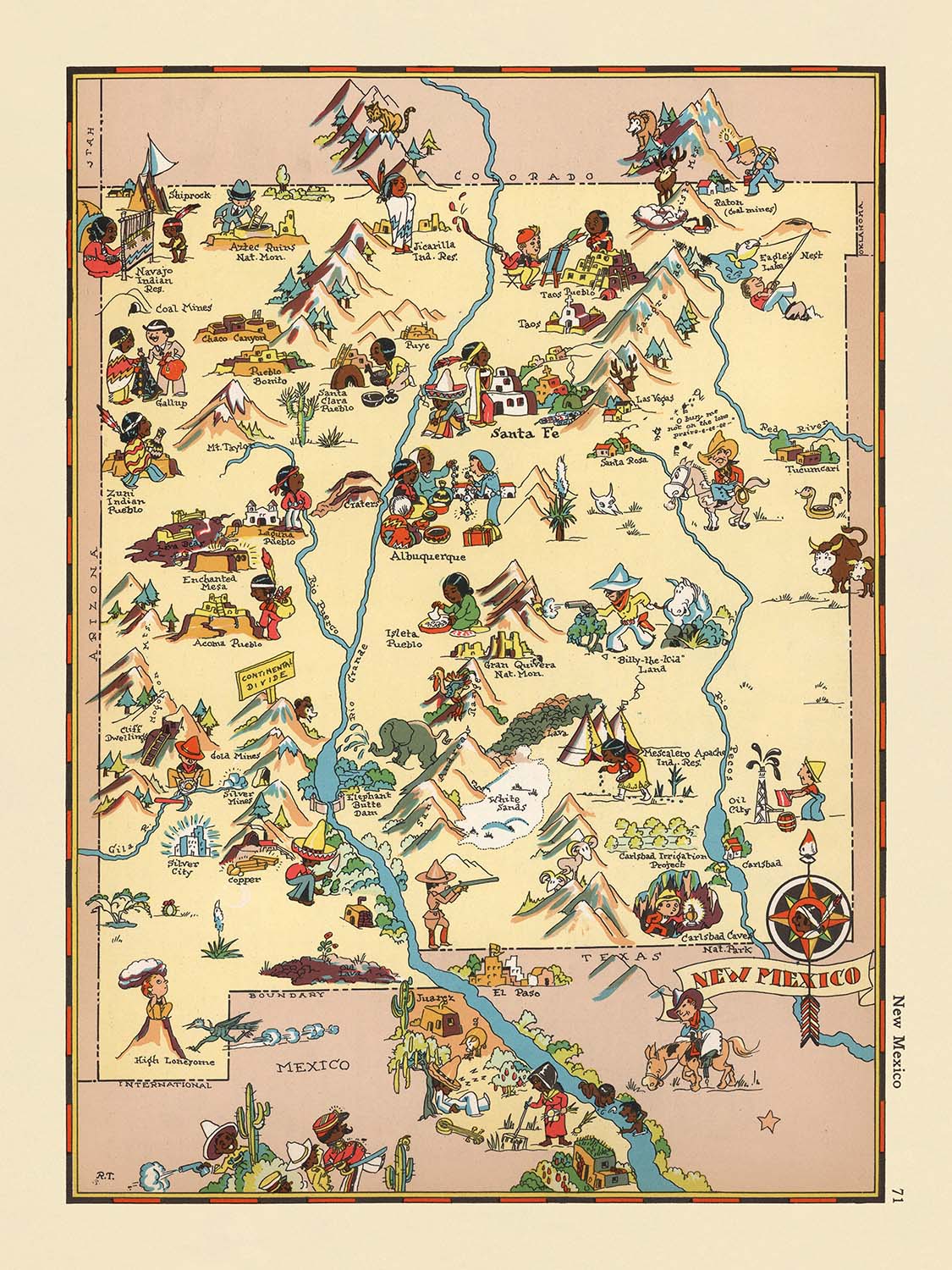
Step into the vibrant tapestry of the American Southwest with “New Mexico,” a captivating pictorial map originally crafted in 1935 by the...
Continue readingStep into the vibrant tapestry of the American Southwest with “New Mexico,” a captivating pictorial map originally crafted in 1935 by the celebrated cartographer Ruth Taylor White. This enchanting map is a standout from White’s whimsical atlas series, where each state is brought to life through a kaleidoscope of color, humor, and keen observation. The original title, “New Mexico,” reflects both the geographical focus and the creative spirit of the era, inviting viewers to explore the Land of Enchantment as it was perceived in the early twentieth century. White’s approach transforms traditional cartography into an engaging visual narrative, blending artistry with geographic precision.
Ruth Taylor White’s legacy as a mapmaker is inseparable from her unique style—her maps are instantly recognizable for their playful, cartoon-like illustrations and meticulous attention to regional character. White’s work transcends mere documentation, offering a vivid snapshot of cultural and social life. In “New Mexico,” she expertly weaves together the state’s diverse influences, from Native American pueblos and Spanish missions to the rugged life of cowboys and miners. Her illustrations not only capture the landscape but also the essence of its people, industries, and traditions, making each map a delightful journey through time and place.
The design of this map is a masterclass in pictorial cartography. County boundaries are elegantly delineated, while the iconic Rio Grande snakes its way through the heart of the state, anchoring the composition. The Sangre de Cristo Mountains rise majestically in the north, and the Gila National Forest unfurls across the southwest, each rendered with artistic flair. White’s whimsical depictions of local wildlife, agricultural scenes, and desert flora—such as cacti and cotton fields—add layers of texture and narrative, inviting the viewer to linger over every detail. The map’s vibrant palette and dynamic illustrations evoke the sun-drenched landscapes and multicultural heritage that define New Mexico.
A highlight of this pictorial masterpiece is its celebration of New Mexico’s most notable landmarks and natural wonders. Carlsbad Caverns, a subterranean marvel, is prominently featured, as are the hot springs that dot the southern landscape. The map pays homage to the Pecos River and the Zuni and Navajo regions, with respectful nods to Indigenous culture and artistry. Mining activity, cattle ranching, and agricultural pursuits are depicted with both accuracy and charm, reflecting the economic lifeblood of the state during the 1930s. Through these vignettes, White’s map becomes a living document of the era’s hopes, challenges, and achievements.
No exploration of “New Mexico” would be complete without noting the constellation of towns and cities that punctuate the map, from Albuquerque and Santa Fe to smaller settlements like Socorro and Silver City. Each is lovingly illustrated, reflecting its unique character and role in the state’s history. The map’s playful style belies its depth of information, offering a window into the social and economic fabric of New Mexico as it stood nearly a century ago. For collectors and connoisseurs of historical cartography, Ruth Taylor White’s “New Mexico” is more than a map—it is an invitation to discover, remember, and celebrate a richly storied land.
Cities and towns on this map
- Albuquerque
- Las Cruces
- Santa Fe
- Rio Rancho
- Roswell
- Farmington
- Clovis
- Hobbs
- Alamogordo
- Carlsbad
- Gallup
- Deming
- Los Alamos
- Silver City
- Raton
- Tucumcari
- Portales
- Socorro
- Truth or Consequences
- Clayton
Notable Features & Landmarks
- County boundaries within New Mexico are clearly delineated.
- The Rio Grande River is prominently illustrated, running north to south through the state.
- Carlsbad Caverns is depicted and labeled, highlighting its significance as a natural landmark.
- The Gila National Forest is illustrated in the southwestern part of the state.
- The Pecos River is shown flowing through eastern New Mexico.
- The Sangre de Cristo Mountains are depicted in the northern part of the state.
- Illustrations of Native American pueblos and cultural scenes are present.
- Images of cowboys and cattle ranching are shown, reflecting the state's ranching heritage.
- Depictions of mining activity, such as miners and mining equipment, are visible.
- Illustrations of agricultural activities, including chili pepper and cotton farming, are present.
- The Zuni and Navajo regions are illustrated with references to Native American culture.
- The map includes whimsical illustrations of local wildlife, such as deer and sheep.
- Hot springs are depicted in the southern part of the state.
- The map features artistic representations of Spanish and Mexican cultural influences.
- The desert landscape and cactus plants are illustrated in the southern and western regions.
Historical and design context
- Name of the map: "New Mexico"
- Date of creation: 1935
- Mapmaker: Ruth Taylor White
- Publisher/context: Part of a pictorial atlas series created by Ruth Taylor White and Frank J. Taylor, known for their whimsical and cartoon-like representations of U.S. states.
- Type of map: County or State Thematic and Pictorial map
- Design/style: The map features vibrant, colorful illustrations with a playful, cartoonish style, typical of pictorial maps from this era.
- Thematic focus: The map highlights stereotypical scenes and cultural elements associated with New Mexico in the 1930s, including depictions of local industries, ethnic groups, and regional activities.
- Artistic approach: The illustrations are whimsical and exaggerated, intended to entertain as well as inform, reflecting social and cultural narratives of the time.
- Historical significance: The map provides insight into how New Mexico was perceived and represented in popular culture during the 1930s, including common stereotypes and notable features of the state.
- Notable context about the mapmaker: Ruth Taylor White was known for her distinctive pictorial maps, which combined humor, artistry, and geographic information, and contributed to the popularization of pictorial cartography in the early 20th century.
Please double check the images to make sure that a specific town or place is shown on this map. You can also get in touch and ask us to check the map for you.
This map looks great at every size, but I always recommend going for a larger size if you have space. That way you can easily make out all of the details.
This map looks amazing at sizes all the way up to 50in (125cm). If you are looking for a larger map, please get in touch.
The model in the listing images is holding the 18x24in (45x60cm) version of this map.
The fifth listing image shows an example of my map personalisation service.
If you’re looking for something slightly different, check out my collection of the best old maps to see if something else catches your eye.
Please contact me to check if a certain location, landmark or feature is shown on this map.
This would make a wonderful birthday, Christmas, Father's Day, work leaving, anniversary or housewarming gift for someone from the areas covered by this map.
This map is available as a giclée print on acid free archival matte paper, or you can buy it framed. The frame is a nice, simple black frame that suits most aesthetics. Please get in touch if you'd like a different frame colour or material. My frames are glazed with super-clear museum-grade acrylic (perspex/acrylite), which is significantly less reflective than glass, safer, and will always arrive in perfect condition.
This map is also available as a float framed canvas, sometimes known as a shadow gap framed canvas or canvas floater. The map is printed on artist's cotton canvas and then stretched over a handmade box frame. We then "float" the canvas inside a wooden frame, which is available in a range of colours (black, dark brown, oak, antique gold and white). This is a wonderful way to present a map without glazing in front. See some examples of float framed canvas maps and explore the differences between my different finishes.
For something truly unique, this map is also available in "Unique 3D", our trademarked process that dramatically transforms the map so that it has a wonderful sense of depth. We combine the original map with detailed topography and elevation data, so that mountains and the terrain really "pop". For more info and examples of 3D maps, check my Unique 3D page.
Step into the vibrant tapestry of the American Southwest with “New Mexico,” a captivating pictorial map originally crafted in 1935 by the celebrated cartographer Ruth Taylor White. This enchanting map is a standout from White’s whimsical atlas series, where each state is brought to life through a kaleidoscope of color, humor, and keen observation. The original title, “New Mexico,” reflects both the geographical focus and the creative spirit of the era, inviting viewers to explore the Land of Enchantment as it was perceived in the early twentieth century. White’s approach transforms traditional cartography into an engaging visual narrative, blending artistry with geographic precision.
Ruth Taylor White’s legacy as a mapmaker is inseparable from her unique style—her maps are instantly recognizable for their playful, cartoon-like illustrations and meticulous attention to regional character. White’s work transcends mere documentation, offering a vivid snapshot of cultural and social life. In “New Mexico,” she expertly weaves together the state’s diverse influences, from Native American pueblos and Spanish missions to the rugged life of cowboys and miners. Her illustrations not only capture the landscape but also the essence of its people, industries, and traditions, making each map a delightful journey through time and place.
The design of this map is a masterclass in pictorial cartography. County boundaries are elegantly delineated, while the iconic Rio Grande snakes its way through the heart of the state, anchoring the composition. The Sangre de Cristo Mountains rise majestically in the north, and the Gila National Forest unfurls across the southwest, each rendered with artistic flair. White’s whimsical depictions of local wildlife, agricultural scenes, and desert flora—such as cacti and cotton fields—add layers of texture and narrative, inviting the viewer to linger over every detail. The map’s vibrant palette and dynamic illustrations evoke the sun-drenched landscapes and multicultural heritage that define New Mexico.
A highlight of this pictorial masterpiece is its celebration of New Mexico’s most notable landmarks and natural wonders. Carlsbad Caverns, a subterranean marvel, is prominently featured, as are the hot springs that dot the southern landscape. The map pays homage to the Pecos River and the Zuni and Navajo regions, with respectful nods to Indigenous culture and artistry. Mining activity, cattle ranching, and agricultural pursuits are depicted with both accuracy and charm, reflecting the economic lifeblood of the state during the 1930s. Through these vignettes, White’s map becomes a living document of the era’s hopes, challenges, and achievements.
No exploration of “New Mexico” would be complete without noting the constellation of towns and cities that punctuate the map, from Albuquerque and Santa Fe to smaller settlements like Socorro and Silver City. Each is lovingly illustrated, reflecting its unique character and role in the state’s history. The map’s playful style belies its depth of information, offering a window into the social and economic fabric of New Mexico as it stood nearly a century ago. For collectors and connoisseurs of historical cartography, Ruth Taylor White’s “New Mexico” is more than a map—it is an invitation to discover, remember, and celebrate a richly storied land.
Cities and towns on this map
- Albuquerque
- Las Cruces
- Santa Fe
- Rio Rancho
- Roswell
- Farmington
- Clovis
- Hobbs
- Alamogordo
- Carlsbad
- Gallup
- Deming
- Los Alamos
- Silver City
- Raton
- Tucumcari
- Portales
- Socorro
- Truth or Consequences
- Clayton
Notable Features & Landmarks
- County boundaries within New Mexico are clearly delineated.
- The Rio Grande River is prominently illustrated, running north to south through the state.
- Carlsbad Caverns is depicted and labeled, highlighting its significance as a natural landmark.
- The Gila National Forest is illustrated in the southwestern part of the state.
- The Pecos River is shown flowing through eastern New Mexico.
- The Sangre de Cristo Mountains are depicted in the northern part of the state.
- Illustrations of Native American pueblos and cultural scenes are present.
- Images of cowboys and cattle ranching are shown, reflecting the state's ranching heritage.
- Depictions of mining activity, such as miners and mining equipment, are visible.
- Illustrations of agricultural activities, including chili pepper and cotton farming, are present.
- The Zuni and Navajo regions are illustrated with references to Native American culture.
- The map includes whimsical illustrations of local wildlife, such as deer and sheep.
- Hot springs are depicted in the southern part of the state.
- The map features artistic representations of Spanish and Mexican cultural influences.
- The desert landscape and cactus plants are illustrated in the southern and western regions.
Historical and design context
- Name of the map: "New Mexico"
- Date of creation: 1935
- Mapmaker: Ruth Taylor White
- Publisher/context: Part of a pictorial atlas series created by Ruth Taylor White and Frank J. Taylor, known for their whimsical and cartoon-like representations of U.S. states.
- Type of map: County or State Thematic and Pictorial map
- Design/style: The map features vibrant, colorful illustrations with a playful, cartoonish style, typical of pictorial maps from this era.
- Thematic focus: The map highlights stereotypical scenes and cultural elements associated with New Mexico in the 1930s, including depictions of local industries, ethnic groups, and regional activities.
- Artistic approach: The illustrations are whimsical and exaggerated, intended to entertain as well as inform, reflecting social and cultural narratives of the time.
- Historical significance: The map provides insight into how New Mexico was perceived and represented in popular culture during the 1930s, including common stereotypes and notable features of the state.
- Notable context about the mapmaker: Ruth Taylor White was known for her distinctive pictorial maps, which combined humor, artistry, and geographic information, and contributed to the popularization of pictorial cartography in the early 20th century.
Please double check the images to make sure that a specific town or place is shown on this map. You can also get in touch and ask us to check the map for you.
This map looks great at every size, but I always recommend going for a larger size if you have space. That way you can easily make out all of the details.
This map looks amazing at sizes all the way up to 50in (125cm). If you are looking for a larger map, please get in touch.
The model in the listing images is holding the 18x24in (45x60cm) version of this map.
The fifth listing image shows an example of my map personalisation service.
If you’re looking for something slightly different, check out my collection of the best old maps to see if something else catches your eye.
Please contact me to check if a certain location, landmark or feature is shown on this map.
This would make a wonderful birthday, Christmas, Father's Day, work leaving, anniversary or housewarming gift for someone from the areas covered by this map.
This map is available as a giclée print on acid free archival matte paper, or you can buy it framed. The frame is a nice, simple black frame that suits most aesthetics. Please get in touch if you'd like a different frame colour or material. My frames are glazed with super-clear museum-grade acrylic (perspex/acrylite), which is significantly less reflective than glass, safer, and will always arrive in perfect condition.
This map is also available as a float framed canvas, sometimes known as a shadow gap framed canvas or canvas floater. The map is printed on artist's cotton canvas and then stretched over a handmade box frame. We then "float" the canvas inside a wooden frame, which is available in a range of colours (black, dark brown, oak, antique gold and white). This is a wonderful way to present a map without glazing in front. See some examples of float framed canvas maps and explore the differences between my different finishes.
For something truly unique, this map is also available in "Unique 3D", our trademarked process that dramatically transforms the map so that it has a wonderful sense of depth. We combine the original map with detailed topography and elevation data, so that mountains and the terrain really "pop". For more info and examples of 3D maps, check my Unique 3D page.
Many of our maps and art prints are chosen as thoughtful gifts for homes, offices, studies and meaningful places.
Choose a framed option for the easiest ready-to-hang gift, or choose an unframed print if the recipient may prefer to select their own frame.
We make orders locally in 23 countries around the world, so gifts can often be produced close to the recipient. This helps them arrive faster, travel more safely, and avoid customs or import duty surprises.
- We can deliver directly to the recipient
- Framed pieces arrive ready to hang
- Unframed prints are carefully packed in a strong protective tube
- Almost every order is made locally, for faster, safer gifting
- 90-day returns give the recipient time to decide
If you are not sure what to choose, please contact us. We can help you pick the right map, size, finish or delivery option.
Most orders are made locally and delivered in around 2–3 working days, depending on the product, size and destination.
We print and frame maps and artwork in 23 countries around the world, so your order is usually made close to you or your recipient. That means faster delivery, less time in transit, and no customs or import duty surprises.
Personalised and customised pieces usually take an extra 1–2 working days, because we prepare your design and send it to you for approval before printing.
Very large framed orders can take a little longer, as they need extra care in production and delivery.
Every order is carefully packaged: unframed prints are sent in a strong protective tube, while framed pieces are securely packed with protective materials around the frame.
If you need your order by a particular date, please contact us before ordering. We’ll check the best production route and delivery option for your location.
Express delivery is available at checkout for most countries. Next-day delivery is available in the UK, US, Singapore and the UAE.
Your order is covered by our 90-day returns policy and 10-year guarantee.
Our standard frame is a gallery-style black ash hardwood frame, with a simple, modern look. It is approximately 20mm (0.8in) wide. You can also view some lovely customer photos of framed maps and art.
We use super-clear acrylic glazing, also known as Perspex or Acrylite, instead of traditional glass. It is lighter, safer, and has lower reflectivity, giving the artwork a clearer, cleaner appearance.
Six standard frame colours are available at no extra cost: black, dark brown, dark grey, oak, white, and antique gold. Custom framing and mounting/matting is also available for customers looking for something more specific.
Most maps, art prints, and illustrations are also available as a framed canvas. We use matte cotton canvas, stretch it over a sustainably sourced wooden box frame, and then float the piece within a wooden outer frame. The finished result is beautifully presented, with no glazing between you and the artwork.
All frames are supplied ready to hang, with either string or brackets fitted to the back. Very large frames will include heavy-duty hanging plates and/or a mounting baton. If you have any questions, please get in touch.
We can also supply old maps and artwork on canvas, foam board, cotton rag, and other materials.
If you would prefer to frame your map or artwork yourself, please read our size guide before ordering.
Every Unique Maps piece begins with an authentic cartographic source or an original design from our London studio.
For our historic maps, we source rare originals from libraries, archives, auction houses and private collections around the world. We carefully restore each map for print—repairing age-related damage, balancing colour and improving clarity while preserving its original detail, texture and character.
Once restored, the map is prepared for your chosen size and finish. Your piece is then printed and, where selected, framed close to its delivery destination.
Our map prints use acid-free 200gsm archival matte paper and fade-resistant pigment inks, creating a rich, non-glossy finish designed to last. Framed maps use crystal-clear optical acrylic and arrive ready to hang.
Canvas, cotton-rag and other specialist presentations are also available. Learn more about our materials and finishes.
Personalising your map
You can add a short title or dedication, mark one meaningful place, or request one considered visual detail. For personalised designs, we send a proof before printing and you can request changes before approval.
For more complex bespoke commissions, contact our design team.
Original or Aged
Choose Original for true-to-source colour, or Aged for a warmer, richer antique character created with our specialist ageing process. See examples of our Aged maps.
If you are not happy with your order for any reason, contact me and I'll get it fixed ASAP, free of charge. Please see my returns and refund policy for more information.
I am very confident you will like your restored map or art print. I have been doing this since 1984. I'm a 5-star Etsy seller. I have sold tens of thousands of maps and art prints and have over 5,000 real 5-star reviews. My work has been featured in interior design magazines, on the BBC, and on the walls of dozens of 5-star hotels.
I use a unique process to restore maps and artwork that is massively time consuming and labour intensive. Hunting down the original maps and illustrations can take months. I use state of the art and eye-wateringly expensive technology to scan and restore them. As a result, I guarantee my maps and art prints are a cut above the rest. I stand by my products and will always make sure you're 100% happy with what you receive.
Almost all of my maps and art prints look amazing at large sizes (200cm, 6.5ft+) and I can frame and deliver them to you as well, via special oversized courier. Contact me to discuss your specific needs.
Or try searching for something!


