


Very Large Map of the Holy Land and Jerusalem by Haines, 1828: American Made, Exodus, Sinai, Solomon’s Temple, Bethlehem
Compra 2, Llévate 1 Gratis
Si añades 2 artículos a tu carrito, puedes añadir un tercer producto gratis.
Esto aplica a todos los mapas y obras de arte, incluyendo piezas personalizadas y personalizadas. Puedes pedir 3 de lo mismo, o 3 cosas diferentes.
Esto equivale a un descuento del 33%, que será el mayor descuento disponible en mi tienda este año.
¡Aprovecha la oferta y cubre tus paredes con hermosos mapas y arte!
Contáctame si tienes alguna pregunta.
-
![]() Handmade in Australia
Handmade in Australia

-
FREE worldwide delivery in 2-3 days ⓘ
Free delivery in 2-3 days
Your map should be delivered in 2-3 working days with free delivery, worldwide.
We make maps by hand locally in 23 countries, including Australia
![]() . If you're buying a gift for someone in another country, we will make the map locally to them.
. If you're buying a gift for someone in another country, we will make the map locally to them.You will never pay import tax or customs duty.
Express delivery is available at checkout which can reduce the delivery time to 1-2 days.
Please note that personalised maps, and larger framed maps, can take longer to produce and deliver.
If you need your order to arrive by a certain date, contact me and we can discuss your options.
-
Complimentary gifting & design advice
ⓘ
Complimentary gifting & design advice
Available almost 24/7 on WhatsApp and email — we usually reply within minutes. We can help you:
- Choose a perfectly personalised gift
- Send a digital gift preview to the recipient
- Pick the ideal size for your wall
- Select the right finish and frame
Quick, friendly advice so you can order with confidence.
For last minute gifts, consider buying a digital gift card. We have over 5,000 maps and art prints to choose from.
-
90-day returns & 5-year guarantee
ⓘ
90 días para devolver y reembolsar
Los productos se pueden devolver dentro de los 90 días para un reembolso completo, o cambio por otro producto.
Para artículos personalizados y hechos a medida, podemos ofrecerte crédito en la tienda o una tarjeta de regalo sin fecha de caducidad, ya que no podemos revender pedidos personalizados.
Si tienes alguna pregunta, ponte en contacto. Para más información, consulta nuestra política de devoluciones y cambios.

This is a museum-grade archival print from the original 1828 map — restored in our workshop and made to order on 220gsm archival matte paper or 400gsm artist's cotton canvas with pigment inks.
Professional framing & free personalisation available.
1. Choose a size
2. Frame & personalise your map
Make your map unique with framing, hand-drawn customisation, vintage ageing, pop art text, unique 3D styling and more.


Mensaje de regalo y acabado personalizado

Si deseas agregar un mensaje de regalo, o un acabado (rompecabezas, tablero de aluminio, etc.) que no esté disponible aquí, por favor solicítalo en la "nota del pedido" cuando realices la compra.
Cada pedido es hecho a medida, así que si necesitas que el tamaño se ajuste ligeramente, o que se imprima en un material inusual, háznoslo saber. Hemos realizado miles de pedidos personalizados a lo largo de los años, así que hay (casi) nada que no podamos gestionar.
También puedes contactarnos antes de hacer tu pedido, ¡si lo prefieres!

- Handmade locally. No import duty or tax
- FREE worldwide delivery
- 90-day returns & 5-year product guarantee
- Questions? WhatsApp me any time
Own a piece of history
7,000+ 5 star reviews


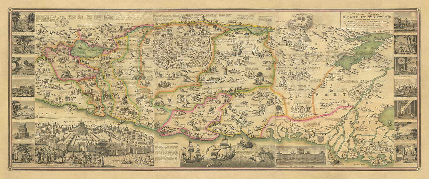
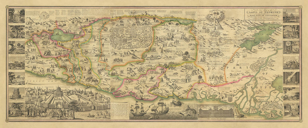
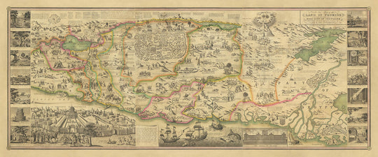
Step into the sacred geography of antiquity with "A New Map of the Land of Promise And the Holy City of Jerusalem," a masterwork of cartographic artistry and biblical storytelling, engraved by D. Haines in 1828. This rare American wall map, with only a handful of known institutional examples, offers a sweeping bird’s-eye perspective of the Holy Land, extending from the storied banks of the Nile and the Red Sea to the ancient cities of Damascus and Sidon. At its heart lies Jerusalem, meticulously rendered and celebrated as the spiritual epicenter of the Abrahamic faiths. The map’s design is not merely geographical—it is a visual tapestry, interweaving sacred history with the landscape itself.
What sets this map apart is its richly illustrated narrative, bringing to life the most pivotal events of the Old and New Testaments. Hundreds of tiny vignettes, each carefully engraved, depict moments such as the Exodus, the crossing of the Red Sea, and Moses receiving the Ten Commandments atop Mount Sinai. These scenes are not mere decoration; they are historical waypoints, inviting the viewer to trace the journeys, struggles, and triumphs of biblical figures across the terrain. The map’s pictorial approach transforms it into a unique artifact—both a work of art and a didactic tool for understanding the ancient world.
The map’s cartographic lineage is equally remarkable. Its format and visual language are directly inspired by the 17th-century Dutch and English traditions, notably van Doetechum’s 1641 prototype and Claes Jansz Visscher’s celebrated plan of Jerusalem. Haines’s edition represents the culmination of nearly two centuries of European and American mapmaking, reinterpreted for a new audience in early 19th-century Philadelphia. This blend of Old World craftsmanship and New World ambition is evident in every detail, from the ornate inset views of Solomon’s Temple to the panoramic “Prospect of Jerusalem” that crowns the composition.
Beyond its aesthetic appeal, the map is a remarkable historical document, capturing a moment when biblical scholarship, religious devotion, and the art of engraving converged in American print culture. Its rarity—attested by the few surviving examples—speaks to its value as both a collector’s item and a testament to the enduring fascination with the Holy Land. For historians, collectors, and connoisseurs of cartography, this map offers an unparalleled window into the ways in which faith, history, and geography have been intertwined across centuries.
The map’s coverage is impressively comprehensive, encompassing iconic locations such as Bethlehem, Jericho, Hebron, Nazareth, and the Sea of Galilee, as well as the vast expanses of Egypt and the Sinai Peninsula. Key biblical routes and encampments are charted with precision, while towns, fortresses, and landmarks are rendered in evocative bird’s-eye perspective. Each element invites exploration, whether you are retracing the footsteps of ancient prophets or simply admiring the artistry of a bygone era. This map is not only a visual feast but also a profound historical artifact—an invitation to journey through the Land of Promise as it was imagined by the cartographers and believers of the past.
Places on this map
- Jerusalem
- Bethlehem
- Jericho
- Hebron
- Damascus
- Sidon
- Cairo
- Mecca
- Mount Sinai
- Nile River
- Red Sea
- Dead Sea
- Jordan River
- Gaza
- Joppa (Jaffa)
- Nazareth
- Sea of Galilee
- Egypt
- Sinai Peninsula
- Samaria
Notable Features & Landmarks
- Prominent bird's-eye view of the city of Jerusalem
- Detailed inset plan of Jerusalem, numbered with key locations
- Inset depiction of Solomon's Temple
- "A Prospect of Jerusalem" panoramic view
- Illustrations depicting biblical events such as:
- The Exodus from Egypt
- Crossing of the Red Sea
- Moses receiving the Ten Commandments at Mount Sinai
- The encampments of the Israelites during their journey
- Depictions of battles and significant biblical events in the region
- Numerous small vignettes illustrating scenes from the Old Testament narratives
- Clearly labeled routes and trails relevant to biblical stories
- Depictions of towns, villages, and fortresses in a pictorial, bird's-eye style
- Nile Delta and Egyptian coast prominently shown
- Sinai Peninsula clearly depicted with Mount Sinai labeled
- The Jordan River and Dead Sea clearly labeled and illustrated
- Illustrations of significant biblical landmarks, such as Bethlehem, Jericho, and Hebron
Historical and design context
- Rare American wall map depicting the Holy Land and Egypt, with only a handful of known institutional examples
- Engraved by D. Haines in 1828, who worked for notable Philadelphia publishers J.H. Young and S. Augustus Mitchell
- Derived from a long tradition of pictorial maps dating back to the 17th-century Dutch cartographer van Doetechum, with subsequent English editions throughout the 18th century
- Richly illustrated with pictorial vignettes, bringing to life pivotal events of the Old and New Testaments
- Features detailed inset views of Jerusalem and Solomon's Temple, inspired by Claes Jansz Visscher’s 17th-century map of Jerusalem
- Represents the culmination of nearly two centuries of European and American mapmaking, reinterpreted for a new audience in early 19th-century Philadelphia
- Historically informative, illustrating biblical events and stories with geographical precision
- Blends Old World craftsmanship and New World ambition in its design and execution
Please double check the images to make sure that a specific town or place is shown on this map. You can also get in touch and ask us to check the map for you.
This is a very large map that must be ordered at a large size, so that you can easily make out all of the details.
This map looks amazing at sizes all the way up to 100in (250cm). If you are looking for a larger map, please get in touch.
The model in the listing images is holding the undefined version of this map.
The fifth listing image shows an example of my map personalisation service.
If you’re looking for something slightly different, check out my collection of the best old maps to see if something else catches your eye.
Please contact me to check if a certain location, landmark or feature is shown on this map.
This would make a wonderful birthday, Christmas, Father's Day, work leaving, anniversary or housewarming gift for someone from the areas covered by this map.
This map is available as a giclée print on acid free archival matte paper, or you can buy it framed. The frame is a nice, simple black frame that suits most aesthetics. Please get in touch if you'd like a different frame colour or material. My frames are glazed with super-clear museum-grade acrylic (perspex/acrylite), which is significantly less reflective than glass, safer, and will always arrive in perfect condition.
This map is also available as a float framed canvas, sometimes known as a shadow gap framed canvas or canvas floater. The map is printed on artist's cotton canvas and then stretched over a handmade box frame. We then "float" the canvas inside a wooden frame, which is available in a range of colours (black, dark brown, oak, antique gold and white). This is a wonderful way to present a map without glazing in front. See some examples of float framed canvas maps and explore the differences between my different finishes.
For something truly unique, this map is also available in "Unique 3D", our trademarked process that dramatically transforms the map so that it has a wonderful sense of depth. We combine the original map with detailed topography and elevation data, so that mountains and the terrain really "pop". For more info and examples of 3D maps, check my Unique 3D page.
Para la mayoría de los pedidos, el tiempo de entrega es de aproximadamente 3 días laborables. Los productos personalizados y a medida tardan más, ya que tengo que hacer la personalización y enviártelo para su aprobación, lo cual suele tardar 1 o 2 días.
Tenga en cuenta que los pedidos enmarcados muy grandes suelen tardar más en fabricarse y entregarse.
Si necesitas que tu pedido llegue para una fecha determinada, por favor contáctame antes de hacer el pedido para que podamos encontrar la mejor manera de asegurarnos de que recibas tu pedido a tiempo.
Imprimo y enmarco mapas y obras de arte en 23 países alrededor del mundo. Esto significa que tu pedido se fabricará localmente, lo que reduce el tiempo de entrega y asegura que no se dañe durante el envío. Nunca pagarás aranceles de aduana o impuestos de importación, y pondremos menos CO2 en el aire.
Todos mis mapas y impresiones artísticas están bien empaquetados y enviados en un tubo resistente si no están enmarcados, o rodeados de espuma si están enmarcados.
Intento enviar todos los pedidos dentro de 1 o 2 días después de recibir tu pedido, aunque algunos productos (como mascarillas, tazas y bolsas de tela) pueden tardar más en fabricarse.
Si seleccionas Entrega Exprés al finalizar la compra, priorizaremos tu pedido y lo enviaremos por mensajería de 1 día (Fedex, DHL, UPS, Parcelforce).
La entrega al día siguiente también está disponible en algunos países (EE. UU., Reino Unido, Singapur, EAU), pero por favor intenta hacer tu pedido temprano en el día para que podamos enviarlo a tiempo.
Mi marco estándar es un marco de madera de fresno negro estilo galería. Es simple y tiene un aspecto bastante moderno. Mi marco estándar tiene alrededor de 20 mm (0.8 in) de ancho.
Utilizo acrílico super claro (perspex/acrylite) para el vidrio del marco. Es más ligero y seguro que el vidrio, y se ve mejor, ya que la reflectividad es menor.
Seis colores de marco estándar están disponibles de forma gratuita (negro, marrón oscuro, gris oscuro, roble, blanco y oro antiguo).El enmarcado y montaje/matizado personalizado está disponible si buscas algo diferente.
La mayoría de los mapas, arte e ilustraciones también están disponibles como un lienzo enmarcado. Utilizamos lienzo de algodón mate (no brillante), lo estiramos sobre un marco de madera de caja de origen sostenible, y luego 'flotamos' la pieza dentro de un marco de madera. El resultado final es bastante hermoso, y no hay cristal que se interponga.
Todos los marcos se proporcionan "listos para colgar", con una cuerda o soportes en la parte posterior. Los marcos muy grandes tendrán placas de colgar de alta resistencia y/o un listón de montaje. Si tienes alguna pregunta, por favor ponte en contacto.
Mira algunos ejemplos de mis mapas enmarcados y mapas en lienzo enmarcados.
Alternativamente, también puedo proporcionar mapas antiguos y obras de arte en lienzo, tablero de espuma, papel de algodón y otros materiales.
Si deseas enmarcar tu mapa o obra de arte tú mismo, por favor lee mi guía de tamaños primero.
Algunos de mis mapas antiguos ahora están disponibles como lienzos enmarcados. Por favor contáctame si deseas pedir un tamaño que no está disponible en mi tienda.
Los mapas antiguos en lienzo son una alternativa interesante a los mapas enmarcados convencionalmente. Dependiendo de tu gusto personal y la decoración de la habitación, los mapas en lienzo pueden "destacar" un poco más que un mapa enmarcado.
Mis mapas son reproducciones de mapas originales de altísima calidad.
Obtengo mapas originales y raros de bibliotecas, casas de subastas y colecciones privadas de todo el mundo, los restauro en mi taller de Londres y luego uso tintas e impresoras giclée especializadas para crear hermosos mapas que lucen incluso mejor que el original.
Mis mapas están impresos en papel de archivo mate (no brillante) sin ácido que se siente de muy alta calidad y casi como una tarjeta. En términos técnicos, el peso/grosor del papel es de 10 mil/200 g/m². Es perfecto para enmarcar.
Imprimo con tintas pigmentadas Epson ultrachrome giclée UV resistentes a la decoloración, algunas de las mejores tintas que puedes encontrar.
yo también puedo hacer mapas sobre lienzo, trapo de algodón y otros materiales exóticos.
Obtenga más información sobre The Unique Maps Co..
Personalización de mapas
Si está buscando el regalo perfecto de aniversario o inauguración de la casa, puedo personalizar su mapa para hacerlo verdaderamente único. Por ejemplo, puedo agregar un mensaje corto, resaltar una ubicación importante o agregar el escudo de armas de su familia.
Las opciones son casi infinitas. Por favor mira mi página de personalización de mapas para ver algunos maravillosos ejemplos de lo que es posible.
Para pedir un mapa personalizado, seleccione "personalizar su mapa" antes de agregarlo a su carrito.
Ponerse en contacto si buscas personalizaciones y personalizaciones más complejas.
Envejecimiento del mapa
A lo largo de los años, los clientes me han preguntado cientos de veces si podían comprar un mapa que se viera uniforme. más viejo.
Bueno, ahora puedes hacerlo seleccionando Envejecido antes de agregar un mapa a tu carrito.
Todas las fotografías de productos que ve en esta página muestran el mapa en su forma original. Así es como se ve el mapa hoy.
Si selecciona Envejecido, envejeceré su mapa a mano, usando un proceso especial y único desarrollado a través de años de estudiar mapas antiguos, hablar con investigadores para comprender la química del envejecimiento del papel y, por supuesto... ¡mucha práctica!
Si no estás seguro, quédate con el color original del mapa. Si quieres algo un poco más oscuro y más viejo buscando, opte por Envejecido.
Si no estás satisfecho con tu pedido por cualquier motivo, contáctame para un reembolso sin complicaciones. Por favor, consulta nuestra política de devoluciones y reembolsos para más información.
Estoy muy seguro de que te gustará tu mapa o impresión artística restaurada. He estado haciendo esto desde 1984. Soy un vendedor de 5 estrellas en Etsy. He vendido decenas de miles de mapas e impresiones artísticas y tengo más de 5,000 opiniones reales de 5 estrellas.
Utilizo un proceso único para restaurar mapas y obras de arte que consume mucho tiempo y mano de obra. Buscar los mapas e ilustraciones originales puede llevar meses. Utilizo tecnología de última generación y extremadamente cara para escanear y restaurarlos. Como resultado, garantizo que mis mapas e impresiones artísticas son superiores a los demás - por eso puedo ofrecer un reembolso sin complicaciones.
Casi todos mis mapas e impresiones artísticas se ven increíbles en tamaños grandes (200cm, 6.5ft+) y también puedo enmarcarlos y entregártelos a través de un servicio de mensajería especial para tamaños grandes. Contáctame para discutir tus necesidades específicas.
Or try searching for something!


