


Old Map of Forests & National Parks in the Western USA by USGS, 1900: Yellowstone, Sierra Nevada, Etc.
Compra 2, Llévate 1 Gratis
Si añades 2 artículos a tu carrito, puedes añadir un tercer producto gratis.
Esto aplica a todos los mapas y obras de arte, incluyendo piezas personalizadas y personalizadas. Puedes pedir 3 de lo mismo, o 3 cosas diferentes.
Esto equivale a un descuento del 33%, que será el mayor descuento disponible en mi tienda este año.
¡Aprovecha la oferta y cubre tus paredes con hermosos mapas y arte!
Contáctame si tienes alguna pregunta.

-
![]() Handmade in Australia
Handmade in Australia
-
FREE worldwide delivery in 2-3 days ⓘ
Free delivery in 2-3 days
Your map should be delivered in 2-3 working days with free delivery, worldwide.
Deliveries over the Christmas and New Year period may be slightly delayed, as couriers and postal services catch up with a huge backlog of packages.
We make maps by hand locally in 23 countries, including Australia
![]() . If you're buying a gift for someone in another country, we will make the map locally to them.
. If you're buying a gift for someone in another country, we will make the map locally to them.You will never pay import tax or customs duty.
Express delivery is available at checkout which can reduce the delivery time to 1-2 days.
Please note that personalised maps, and larger framed maps, can take longer to produce and deliver.
If you need your order to arrive by a certain date, contact me and we can discuss your options.
-
FREE gift preview
ⓘ
Digital gift preview
After you complete your order, you can send a beautiful digital preview to the gift recipient. Just provide their email address and we'll do the rest. (Their email address will not be stored or used for any other purpose.)
This is perfect if you're concerned that your order might not arrive in time.
You can also buy a real non-expiring gift card, and email it directly to the recipient, so they can buy their own map or artwork.
-
90 day money back guarantee
ⓘ
90 días para devolver y reembolsar
Los productos se pueden devolver dentro de los 90 días para un reembolso completo, o cambio por otro producto.
Para artículos personalizados y hechos a medida, podemos ofrecerte crédito en la tienda o una tarjeta de regalo sin fecha de caducidad, ya que no podemos revender pedidos personalizados.
Si tienes alguna pregunta, ponte en contacto. Para más información, consulta nuestra política de devoluciones y cambios.

My maps are rare, museum-grade, restored old maps sourced from libraries, auction houses and private collections across the globe.
Framing & free personalisation available
1. Select your size
Click here to order a custom size.
2. Frame & personalise your map
Make your map unique with framing, hand-drawn customisation, vintage ageing, pop art text, unique 3D styling and more.


Mensaje de regalo y acabado personalizado

Si deseas agregar un mensaje de regalo, o un acabado (rompecabezas, tablero de aluminio, etc.) que no esté disponible aquí, por favor solicítalo en la "nota del pedido" cuando realices la compra.
Cada pedido es hecho a medida, así que si necesitas que el tamaño se ajuste ligeramente, o que se imprima en un material inusual, háznoslo saber. Hemos realizado miles de pedidos personalizados a lo largo de los años, así que hay (casi) nada que no podamos gestionar.
También puedes contactarnos antes de hacer tu pedido, ¡si lo prefieres!

- Handmade locally. No import duty or tax
- FREE worldwide delivery
- Love it or your money back (90 days)
- Questions? WhatsApp me any time
Own a piece of history
5,000+ 5 star reviews


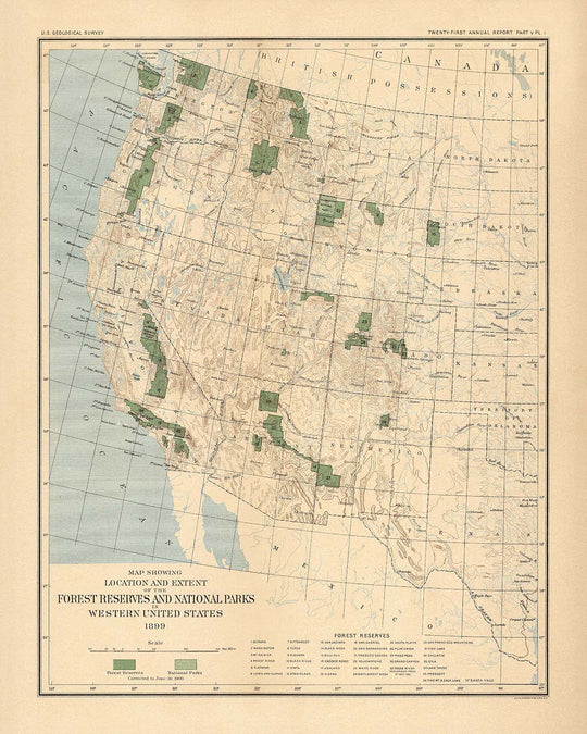
Step into the dawn of American conservation with "Plate I. The Forest Reserves and National Parks in Western United States, 1899," a masterwork of cartographic history crafted by the venerable US Geological Survey (USGS) in 1900. This map is a visual testament to a pivotal era, when the United States first turned its attention to preserving the wild grandeur of its western lands. The map’s original title alone evokes the ambition and vision of the age, as it meticulously charts the newly established National Parks and Forest Reserves west of the 97th meridian. This was a time when the boundaries of wilderness and civilization were still being negotiated, and the contours of the American landscape were being formally inscribed for the very first time.
The USGS, established in 1879, was at the forefront of this monumental task, bringing scientific rigor and artistic precision to the mapping of the nation’s most treasured natural regions. Their expertise is evident in the elegant use of contour lines and subtle color gradations, which together bring to life the rugged relief of the Sierra Nevada, Cascade Range, and Rocky Mountains. Every detail, from the demarcation of state borders to the careful shading of protected lands, reflects the Survey’s dual commitment to accuracy and beauty. This map is not only a navigational tool but a work of art, capturing the interplay of geography, policy, and natural wonder at the turn of the 20th century.
The map’s thematic focus is both timely and visionary. At its heart are the great National Parks and Forest Reserves—Yellowstone, Lewis and Clarke, Mount Rainier, Olympic, Cascade Range, Stanislaus, and Lake Tahoe—each boldly delineated as beacons of the nascent conservation movement. These protected areas, highlighted in distinct colors, stand in contrast to the surrounding unreserved lands, underscoring the early federal commitment to safeguarding America’s forests and watersheds. The map also captures the sweep of major mountain ranges and the subtle undulations of the western landscape, inviting the viewer to trace the paths of rivers, follow the rise of peaks, and imagine the forests as they once stood.
Beyond its visual allure, this map is a key to understanding the historical context of American land management. Published as part of a monumental 711-page collection, it was accompanied by detailed reports on the classification of lands and the condition of timber resources, authored by some of the era’s leading scientific minds. These documents provide a window into the challenges and triumphs of early conservationists, whose efforts laid the groundwork for the modern National Forest and National Park systems. The map itself thus serves as both a snapshot of a formative moment and a touchstone for anyone interested in the evolution of American environmental policy.
Anchoring the wilderness are the burgeoning cities and towns of the West—San Francisco, Los Angeles, Seattle, Denver, and others—each labeled with care and set against the vastness of their natural surroundings. These settlements, now metropolises, were then outposts on the edge of the unknown, their fortunes intertwined with the fate of the forests and mountains that surrounded them. This juxtaposition of civilization and wilderness, rendered with such skill by the USGS, makes the map a powerful artifact of American identity—one that speaks to the enduring tension between development and preservation, and the timeless allure of the wild frontier.
Cities and towns on this map
- California:
- San Francisco
- Los Angeles
- San Diego
- Sacramento
- Washington:
- Seattle
- Spokane
- Tacoma
- Oregon:
- Portland
- Colorado:
- Denver
- Arizona:
- Phoenix
- Utah:
- Salt Lake City
Notable Features & Landmarks
- National Parks are clearly labeled and highlighted, including Yellowstone National Park.
- Forest Reserves are distinctly marked, such as:
- Lewis and Clarke Forest Reserve (Montana)
- Mount Rainier Forest Reserve (Washington)
- Olympic Forest Reserve (Washington)
- Cascade Range Forest Reserve (Oregon/Washington)
- Stanislaus Forest Reserve (California)
- Lake Tahoe Forest Reserve (California/Nevada)
- State boundaries are clearly delineated.
- Major mountain ranges, such as the Sierra Nevada, Cascade Range, and Rocky Mountains, are depicted with relief contours.
- The 97th meridian west is marked as the eastern boundary of the map’s focus.
- Color shading is used to differentiate forest reserves and national parks from other lands.
Historical and design context
- Name of the map: Plate I. The Forest Reserves and National Parks in Western United States, 1899.
- Date of creation: Map updated to June 30, 1900; published by the US Geological Survey (USGS) in 1900.
- Mapmaker/publisher: US Geological Survey (USGS), a federal scientific agency established in 1879, known for mapping and studying the natural resources and landscapes of the United States.
- Geographic coverage: Focuses on the western United States, specifically areas west of the 97th meridian west, including states such as California, Oregon, Washington, Idaho, Montana, Wyoming, Colorado, Utah, Arizona, and New Mexico.
- Map type: County or State Thematic map, emphasizing land management and conservation themes.
- Main topics and themes: Depicts National Parks and Forest Reserves, highlighting early federal conservation efforts and land classifications at the turn of the 20th century.
- Design/style: Relief is shown using contour lines and color, enhancing the visualization of mountainous and forested regions.
- Historical significance: The map is part of a larger publication (711 pages, 39 maps) that documents the early development and management of U.S. forest reserves, reflecting the growing conservation movement of the era.
- Contextual importance: Provides a comprehensive overview of federal land management, conservation policies, and the geographical distribution of protected areas in the western U.S. around 1900.
- Notable for: Being a primary source for historians studying the origins of the U.S. National Forest and National Park systems.
Please double check the images to make sure that a specific town or place is shown on this map. You can also get in touch and ask us to check the map for you.
This map looks great at every size, but I always recommend going for a larger size if you have space. That way you can easily make out all of the details.
This map looks amazing at sizes all the way up to 50in (125cm). If you are looking for a larger map, please get in touch.
The model in the listing images is holding the 16x20in (40x50cm) version of this map.
The fifth listing image shows an example of my map personalisation service.
If you’re looking for something slightly different, check out my collection of the best old maps to see if something else catches your eye.
Please contact me to check if a certain location, landmark or feature is shown on this map.
This would make a wonderful birthday, Christmas, Father's Day, work leaving, anniversary or housewarming gift for someone from the areas covered by this map.
This map is available as a giclée print on acid free archival matte paper, or you can buy it framed. The frame is a nice, simple black frame that suits most aesthetics. Please get in touch if you'd like a different frame colour or material. My frames are glazed with super-clear museum-grade acrylic (perspex/acrylite), which is significantly less reflective than glass, safer, and will always arrive in perfect condition.
This map is also available as a float framed canvas, sometimes known as a shadow gap framed canvas or canvas floater. The map is printed on artist's cotton canvas and then stretched over a handmade box frame. We then "float" the canvas inside a wooden frame, which is available in a range of colours (black, dark brown, oak, antique gold and white). This is a wonderful way to present a map without glazing in front. See some examples of float framed canvas maps and explore the differences between my different finishes.
For something truly unique, this map is also available in "Unique 3D", our trademarked process that dramatically transforms the map so that it has a wonderful sense of depth. We combine the original map with detailed topography and elevation data, so that mountains and the terrain really "pop". For more info and examples of 3D maps, check my Unique 3D page.
Para la mayoría de los pedidos, el tiempo de entrega es de aproximadamente 3 días laborables. Los productos personalizados y a medida tardan más, ya que tengo que hacer la personalización y enviártelo para su aprobación, lo cual suele tardar 1 o 2 días.
Tenga en cuenta que los pedidos enmarcados muy grandes suelen tardar más en fabricarse y entregarse.
Si necesitas que tu pedido llegue para una fecha determinada, por favor contáctame antes de hacer el pedido para que podamos encontrar la mejor manera de asegurarnos de que recibas tu pedido a tiempo.
Imprimo y enmarco mapas y obras de arte en 23 países alrededor del mundo. Esto significa que tu pedido se fabricará localmente, lo que reduce el tiempo de entrega y asegura que no se dañe durante el envío. Nunca pagarás aranceles de aduana o impuestos de importación, y pondremos menos CO2 en el aire.
Todos mis mapas y impresiones artísticas están bien empaquetados y enviados en un tubo resistente si no están enmarcados, o rodeados de espuma si están enmarcados.
Intento enviar todos los pedidos dentro de 1 o 2 días después de recibir tu pedido, aunque algunos productos (como mascarillas, tazas y bolsas de tela) pueden tardar más en fabricarse.
Si seleccionas Entrega Exprés al finalizar la compra, priorizaremos tu pedido y lo enviaremos por mensajería de 1 día (Fedex, DHL, UPS, Parcelforce).
La entrega al día siguiente también está disponible en algunos países (EE. UU., Reino Unido, Singapur, EAU), pero por favor intenta hacer tu pedido temprano en el día para que podamos enviarlo a tiempo.
Mi marco estándar es un marco de madera de fresno negro estilo galería. Es simple y tiene un aspecto bastante moderno. Mi marco estándar tiene alrededor de 20 mm (0.8 in) de ancho.
Utilizo acrílico super claro (perspex/acrylite) para el vidrio del marco. Es más ligero y seguro que el vidrio, y se ve mejor, ya que la reflectividad es menor.
Seis colores de marco estándar están disponibles de forma gratuita (negro, marrón oscuro, gris oscuro, roble, blanco y oro antiguo).El enmarcado y montaje/matizado personalizado está disponible si buscas algo diferente.
La mayoría de los mapas, arte e ilustraciones también están disponibles como un lienzo enmarcado. Utilizamos lienzo de algodón mate (no brillante), lo estiramos sobre un marco de madera de caja de origen sostenible, y luego 'flotamos' la pieza dentro de un marco de madera. El resultado final es bastante hermoso, y no hay cristal que se interponga.
Todos los marcos se proporcionan "listos para colgar", con una cuerda o soportes en la parte posterior. Los marcos muy grandes tendrán placas de colgar de alta resistencia y/o un listón de montaje. Si tienes alguna pregunta, por favor ponte en contacto.
Mira algunos ejemplos de mis mapas enmarcados y mapas en lienzo enmarcados.
Alternativamente, también puedo proporcionar mapas antiguos y obras de arte en lienzo, tablero de espuma, papel de algodón y otros materiales.
Si deseas enmarcar tu mapa o obra de arte tú mismo, por favor lee mi guía de tamaños primero.
Algunos de mis mapas antiguos ahora están disponibles como lienzos enmarcados. Por favor contáctame si deseas pedir un tamaño que no está disponible en mi tienda.
Los mapas antiguos en lienzo son una alternativa interesante a los mapas enmarcados convencionalmente. Dependiendo de tu gusto personal y la decoración de la habitación, los mapas en lienzo pueden "destacar" un poco más que un mapa enmarcado.
Mis mapas son reproducciones de mapas originales de altísima calidad.
Obtengo mapas originales y raros de bibliotecas, casas de subastas y colecciones privadas de todo el mundo, los restauro en mi taller de Londres y luego uso tintas e impresoras giclée especializadas para crear hermosos mapas que lucen incluso mejor que el original.
Mis mapas están impresos en papel de archivo mate (no brillante) sin ácido que se siente de muy alta calidad y casi como una tarjeta. En términos técnicos, el peso/grosor del papel es de 10 mil/200 g/m². Es perfecto para enmarcar.
Imprimo con tintas pigmentadas Epson ultrachrome giclée UV resistentes a la decoloración, algunas de las mejores tintas que puedes encontrar.
yo también puedo hacer mapas sobre lienzo, trapo de algodón y otros materiales exóticos.
Obtenga más información sobre The Unique Maps Co..
Personalización de mapas
Si está buscando el regalo perfecto de aniversario o inauguración de la casa, puedo personalizar su mapa para hacerlo verdaderamente único. Por ejemplo, puedo agregar un mensaje corto, resaltar una ubicación importante o agregar el escudo de armas de su familia.
Las opciones son casi infinitas. Por favor mira mi página de personalización de mapas para ver algunos maravillosos ejemplos de lo que es posible.
Para pedir un mapa personalizado, seleccione "personalizar su mapa" antes de agregarlo a su carrito.
Ponerse en contacto si buscas personalizaciones y personalizaciones más complejas.
Envejecimiento del mapa
A lo largo de los años, los clientes me han preguntado cientos de veces si podían comprar un mapa que se viera uniforme. más viejo.
Bueno, ahora puedes hacerlo seleccionando Envejecido antes de agregar un mapa a tu carrito.
Todas las fotografías de productos que ve en esta página muestran el mapa en su forma original. Así es como se ve el mapa hoy.
Si selecciona Envejecido, envejeceré su mapa a mano, usando un proceso especial y único desarrollado a través de años de estudiar mapas antiguos, hablar con investigadores para comprender la química del envejecimiento del papel y, por supuesto... ¡mucha práctica!
Si no estás seguro, quédate con el color original del mapa. Si quieres algo un poco más oscuro y más viejo buscando, opte por Envejecido.
Si no estás satisfecho con tu pedido por cualquier motivo, contáctame para un reembolso sin complicaciones. Por favor, consulta nuestra política de devoluciones y reembolsos para más información.
Estoy muy seguro de que te gustará tu mapa o impresión artística restaurada. He estado haciendo esto desde 1984. Soy un vendedor de 5 estrellas en Etsy. He vendido decenas de miles de mapas e impresiones artísticas y tengo más de 5,000 opiniones reales de 5 estrellas.
Utilizo un proceso único para restaurar mapas y obras de arte que consume mucho tiempo y mano de obra. Buscar los mapas e ilustraciones originales puede llevar meses. Utilizo tecnología de última generación y extremadamente cara para escanear y restaurarlos. Como resultado, garantizo que mis mapas e impresiones artísticas son superiores a los demás - por eso puedo ofrecer un reembolso sin complicaciones.
Casi todos mis mapas e impresiones artísticas se ven increíbles en tamaños grandes (200cm, 6.5ft+) y también puedo enmarcarlos y entregártelos a través de un servicio de mensajería especial para tamaños grandes. Contáctame para discutir tus necesidades específicas.
Or try searching for something!


