


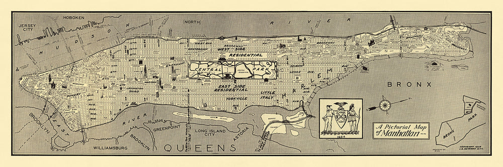
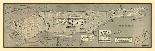


Mappa Pittorica Antica di Manhattan di Seidman, 1939: Central Park, Empire State, Harlem, Times Square, Broadway

-
![]() Handmade in Australia
Handmade in Australia
-
FREE worldwide delivery in 2-3 days ⓘ
Free delivery in 2-3 days
Your map should be delivered in 2-3 working days with free delivery, worldwide.
We make maps by hand locally in 23 countries, including Australia
![]() . If you're buying a gift for someone in another country, we will make the map locally to them.
. If you're buying a gift for someone in another country, we will make the map locally to them.You will never pay import tax or customs duty.
Express delivery is available at checkout which can reduce the delivery time to 1-2 days.
Please note that personalised maps, and larger framed maps, can take longer to produce and deliver.
If you need your order to arrive by a certain date, contact me and we can discuss your options.
-
90 day money back guarantee
ⓘ
90 giorni per restituire e ottenere un rimborso
I prodotti possono essere restituiti entro 90 giorni per un rimborso completo, o scambio con un altro prodotto.
Per articoli personalizzati o su misura, potremmo offrirti un credito in negozio o una carta regalo non scadente, poiché non possiamo rivendere ordini personalizzati.
Se hai domande, contattaci. Per ulteriori informazioni, consulta la nostra politica di restituzione e scambio.

My maps are rare, museum-grade, restored old maps sourced from libraries, auction houses and private collections across the globe.
Framing & free personalisation available
1. Select your size
2. Frame & personalise your map
Make your map unique with framing, hand-drawn customisation, vintage ageing, pop art text, unique 3D styling and moreGift message & custom finish

If you want to add a gift message, or a finish (jigsaw, aluminium board, etc.) that is not available here, please request it in the "order note" when you check out.
Every order is custom made, so if you need the size adjusted slightly, or printed on an unusual material, just let us know. We've done thousands of custom orders over the years, so there's (almost) nothing we can't manage.
You can also contact us before you order, if you prefer!

- Handmade locally. No import duty or tax
- FREE Delivery. Arrives in 2-3 days
- Love it or your money back
- Questions? WhatsApp me any time
Own a piece of history
5,000+ 5 star reviews


"Una Mappa Pittorica di Manhattan," creata da A. Inn e I.S. Seidman nel 1939, è una straordinaria rappresentazione visiva di una delle città più iconiche del mondo. Questa mappa cattura l'essenza di Manhattan con un mix di illustrazioni artistiche e dettagli meticolosi. Ogni quartiere è distintamente etichettato, dal vivace Distretto Finanziario al fascino bohémien di Greenwich Village. La mappa è un vivace istantanea di Manhattan prima della Seconda Guerra Mondiale, offrendo uno sguardo nella ricca storia e nei luoghi culturali della città.
Il cartografo, I.S. Seidman, era rinomato per la sua capacità di combinare elementi tematici con una cartografia precisa. Il suo lavoro su questa mappa non fa eccezione, mostrando la complessa rete di strade e viali di Manhattan. L'attenzione ai dettagli di Seidman è evidente nell'etichettatura accurata di tutte le strade e dei principali punti di riferimento, rendendo questa mappa non solo un bellissimo pezzo d'arte ma anche un prezioso documento storico. L'inclusione di strutture iconiche come l'Empire State Building e la Statua della Libertà aggiunge un ulteriore livello di profondità e significato alla mappa.
Uno degli aspetti più affascinanti di questa mappa è la sua rappresentazione dei diversi quartieri di Manhattan. Il Ghetto dell'East Side, le aree residenziali dell'East Side e del West Side sono tutte presentate in modo prominente, riflettendo il variegato paesaggio socio-economico della città. La mappa evidenzia anche la vivacità culturale di Harlem e il fascino pittoresco di Yorkville. Ogni quartiere prende vita con elementi illustrativi che catturano il carattere unico e la storia di queste aree.
Gli spazi verdi di Manhattan sono anche splendidamente illustrati su questa mappa. Central Park, l'ampio oasi urbana della città, è presentato in modo prominente, insieme ad altri parchi significativi come Riverside Park, Morningside Park e Washington Square Park. Questi spazi verdi offrono un netto contrasto con le strade densamente popolate e i grattacieli imponenti, offrendo uno sguardo all'impegno della città nel preservare la bellezza naturale in mezzo allo sviluppo urbano.
La rappresentazione dei fiumi e delle aree circostanti di Manhattan aggiunge un ulteriore livello di contesto storico. Il fiume Hudson e il fiume Est sono chiaramente contrassegnati, insieme a regioni vicine come Jersey City, Hoboken, Brooklyn e Queens. Questa visione complessiva di Manhattan e dei suoi dintorni fornisce una comprensione più ampia del significato geografico e culturale della città. "Una Mappa Pittorica di Manhattan" non è solo una mappa; è un artefatto storico che cattura lo spirito e l'essenza di New York City alla fine degli anni '30.
Strade e vie su questa mappa
- 1st Avenue
- 2nd Avenue
- 3rd Avenue
- 4th Avenue
- 5th Avenue
- 6th Avenue
- 7th Avenue
- 8th Avenue
- 9th Avenue
- 10th Avenue
- 11th Avenue
- 12th Avenue
- Amsterdam Avenue
- Avenue A
- Avenue B
- Avenue C
- Avenue D
- Broadway
- Columbus Avenue
- East End Avenue
- Lexington Avenue
- Madison Avenue
- Park Avenue
- Riverside Drive
- St. Nicholas Avenue
- West End Avenue
Caratteristiche e Luoghi Notabili
- Illustrazioni:
- Elementi illustrativi per i principali punti di riferimento come la Statua della Libertà, l'Empire State Building e Central Park.
- Punti di riferimento:
- Statua della Libertà
- Empire State Building
- Times Square
- Grand Central Station
- Penn Station
- Nazioni Unite
- Woolworth Building
- Rockefeller Center
- La Piccola Chiesa Dietro l'Angolo
- I Cloisters
- Università di Columbia
- City College
- Yankee Stadium
- Quartieri:
- Financial District
- Greenwich Village
- East Side Ghetto
- East Side Residenziale
- West Side Residenziale
- Harlem
- Yorkville
- Grandi parchi:
- Central Park
- Bronx Park
- Riverside Park
- Morningside Park
- Washington Square Park
- Union Square Park
- Tompkins Square Park
- East River Park
Contesto storico e di design
- Nome della mappa: Una Mappa Pittorica di Manhattan
- Data di creazione: 1939
- Cartografo/Editore: A. Inn & I.S. Seidman
- Contesto interessante sui cartografi: I.S. Seidman era noto per creare mappe dettagliate e artistiche, spesso con un focus su elementi tematici e pittorici.
- Argomenti e temi mostrati sulla mappa:
- Rappresentazione tematica e pittorica della città
- Focus su quartieri e punti di riferimento
- Elementi illustrativi per evidenziare aree e strutture significative
- Paesi e regioni mostrati:
- Manhattan, New York City
- Aree circostanti come Jersey City, Hoboken, Brooklyn, Queens e il Bronx
- Design o stile:
- La mappa utilizza uno stile pittorico e illustrativo per rappresentare Manhattan.
- Combina etichette dettagliate con illustrazioni artistiche.
- Significato storico:
- La mappa fornisce un'istantanea di Manhattan nel 1939, catturando la disposizione della città e le caratteristiche notevoli di quell'epoca.
- Riflette lo sviluppo urbano e i punti di riferimento culturali di Manhattan prima della Seconda Guerra Mondiale.
Si prega di controllare attentamente le immagini per assicurarsi che una specifica città o luogo sia mostrato su questa mappa. Puoi anche contattarci e chiedere di controllare la mappa per te.
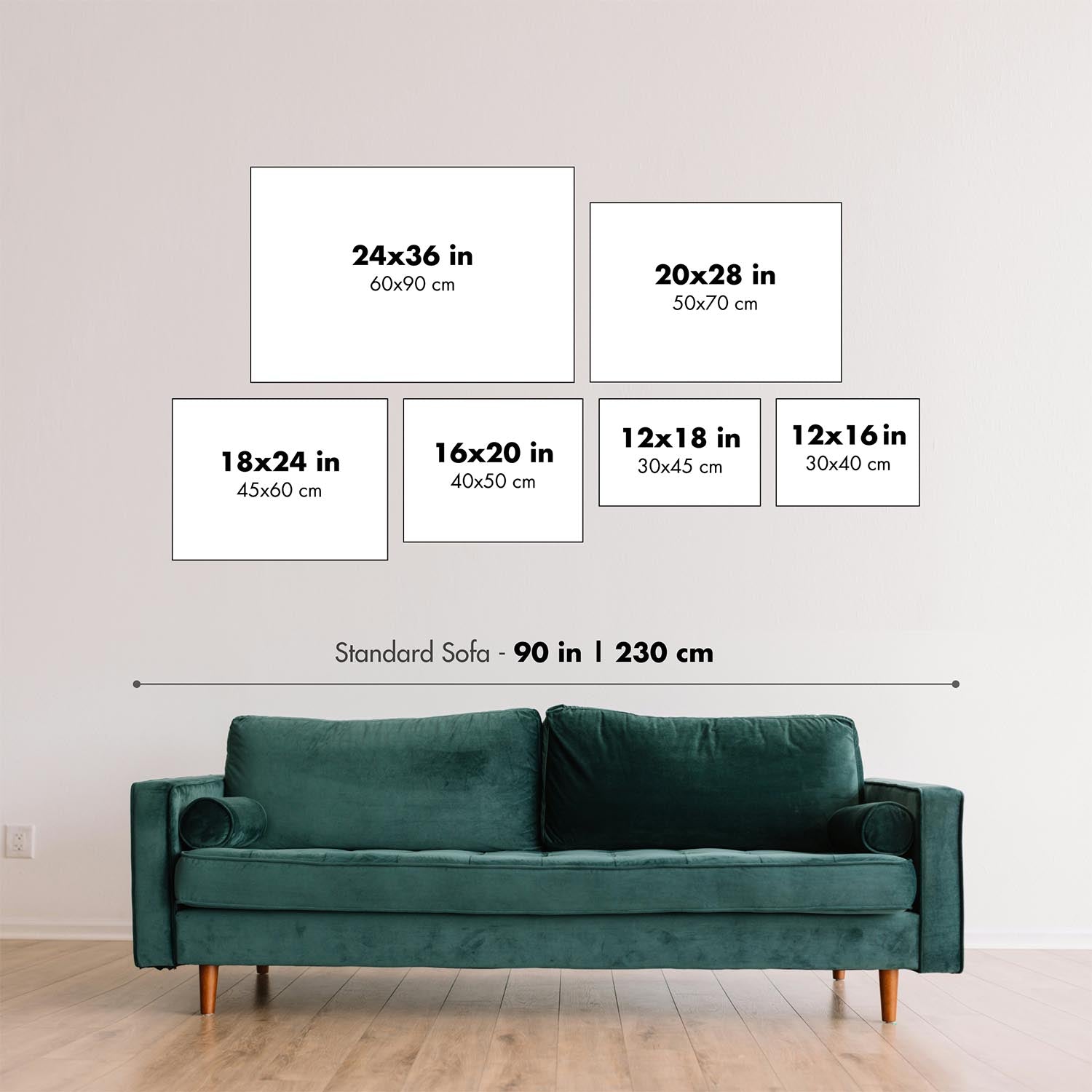
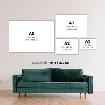
Questa mappa appare fantastica in ogni dimensione, ma consiglio sempre di optare per una dimensione più grande se hai spazio. In questo modo puoi facilmente distinguere tutti i dettagli.
Questa mappa appare straordinaria in dimensioni fino a 100in (250cm). Se stai cercando una mappa più grande, ti preghiamo di contattarci.
Si prega di notare: le etichette su questa mappa sono difficili da leggere se ordini una mappa di 36in (90cm) o più piccola. La mappa è comunque molto attraente, ma se desideri leggere facilmente la mappa, ti preghiamo di acquistare una dimensione più grande.
Questa mappa è più larga della maggior parte delle mappe, il che la renderebbe un pezzo d'arredo perfetto sopra un camino, un divano o una scrivania.
La quinta immagine di elenco mostra un esempio del mio servizio di personalizzazione della mappa.
Se stai cercando qualcosa di leggermente diverso, dai un'occhiata alla mia collezione delle migliori mappe antiche per vedere se qualcosa attira la tua attenzione.
Ti preghiamo di contattarmi per verificare se una certa posizione, punto di riferimento o caratteristica è mostrata su questa mappa.
Questo sarebbe un meraviglioso regalo di compleanno, Natale, Festa del Papà, di congedo lavorativo, anniversario o di inaugurazione della casa per qualcuno delle aree coperte da questa mappa.
Questa mappa è disponibile come stampa giclée su carta opaca archiviata senza acidi, oppure puoi acquistarla incorniciata. La cornice è una bella e semplice cornice nera che si adatta alla maggior parte degli stili. Ti preghiamo di contattarci se desideri un colore o un materiale diverso per la cornice. Le mie cornici sono dotate di vetro acrilico super chiaro di grado museale (perspex/acrylite), che è significativamente meno riflettente del vetro, più sicuro e arriverà sempre in perfette condizioni.
This map is also available as a float framed canvas, sometimes known as a shadow gap framed canvas or canvas floater. The map is printed on artist's cotton canvas and then stretched over a handmade box frame. We then "float" the canvas inside a wooden frame, which is available in a range of colours (black, dark brown, oak, antique gold and white). This is a wonderful way to present a map without glazing in front. See some examples of float framed canvas maps and explore the differences between my different finishes.
For something truly unique, this map is also available in "Unique 3D", our trademarked process that dramatically transforms the map so that it has a wonderful sense of depth. We combine the original map with detailed topography and elevation data, so that mountains and the terrain really "pop". For more info and examples of 3D maps, check my Unique 3D page.
For most orders, delivery time is about 3 working days. Personalised and customised products take longer, as I have to do the personalisation and send it to you for approval, which usually takes 1 or 2 days.
Please note that very large framed orders usually take longer to make and deliver.
If you need your order to arrive by a certain date, please contact me before you order so that we can find the best way of making sure you get your order in time.
I print and frame maps and artwork in 23 countries around the world. This means your order will be made locally, which cuts down on delivery time and ensures that it won't be damaged during delivery. You'll never pay customs or import duty, and we'll put less CO2 into the air.
All of my maps and art prints are well packaged and sent in a rugged tube if unframed, or surrounded by foam if framed.
I try to send out all orders within 1 or 2 days of receiving your order, though some products (like face masks, mugs and tote bags) can take longer to make.
If you select Express Delivery at checkout your order we will prioritise your order and send it out by 1-day courier (Fedex, DHL, UPS, Parcelforce).
Next Day delivery is also available in some countries (US, UK, Singapore, UAE) but please try to order early in the day so that we can get it sent out on time.
My standard frame is a gallery style black ash hardwood frame. It is simple and quite modern looking. My standard frame is around 20mm (0.8in) wide.
I use super-clear acrylic (perspex/acrylite) for the frame glass. It's lighter and safer than glass - and it looks better, as the reflectivity is lower.
Six standard frame colours are available for free (black, dark brown, dark grey, oak, white and antique gold). Custom framing and mounting/matting is available if you're looking for something else.
Most maps, art and illustrations are also available as a framed canvas. We use matte (not shiny) cotton canvas, stretch it over a sustainably sourced box wood frame, and then 'float' the piece within a wood frame. The end result is quite beautiful, and there's no glazing to get in the way.
All frames are provided "ready to hang", with either a string or brackets on the back. Very large frames will have heavy duty hanging plates and/or a mounting baton. If you have any questions, please get in touch.
See some examples of my framed maps and framed canvas maps.
Alternatively, I can also supply old maps and artwork on canvas, foam board, cotton rag and other materials.
If you want to frame your map or artwork yourself, please read my size guide first.
Alcune delle mie vecchie mappe sono ora disponibili come tele incorniciate. Per favore contattami se desideri ordinare una dimensione che non è disponibile nel mio negozio.
Le vecchie mappe su tela sono un'alternativa interessante alle mappe incorniciate in modo convenzionale. A seconda del tuo gusto personale e dell'arredamento della stanza, le mappe su tela possono "risaltare" un po' di più rispetto a una mappa incorniciata.
My maps are extremely high quality reproductions of original maps.
I source original, rare maps from libraries, auction houses and private collections around the world, restore them at my London workshop, and then use specialist giclée inks and printers to create beautiful maps that look even better than the original.
My maps are printed on acid-free archival matte (not glossy) paper that feels very high quality and almost like card. In technical terms the paper weight/thickness is 10mil/200gsm. It's perfect for framing.
I print with Epson ultrachrome giclée UV fade resistant pigment inks - some of the best inks you can find.
I can also make maps on canvas, cotton rag and other exotic materials.
Learn more about The Unique Maps Co.
Map personalisation
If you're looking for the perfect anniversary or housewarming gift, I can personalise your map to make it truly unique. For example, I can add a short message, or highlight an important location, or add your family's coat of arms.
The options are almost infinite. Please see my map personalisation page for some wonderful examples of what's possible.
To order a personalised map, select "personalise your map" before adding it to your basket.
Get in touch if you're looking for more complex customisations and personalisations.
Map ageing
I have been asked hundreds of times over the years by customers if they could buy a map that looks even older.
Well, now you can, by selecting Aged before you add a map to your basket.
All the product photos you see on this page show the map in its Original form. This is what the map looks like today.
If you select Aged, I will age your map by hand, using a special and unique process developed through years of studying old maps, talking to researchers to understand the chemistry of aging paper, and of course... lots of practice!
If you're unsure, stick to the Original colour of the map. If you want something a bit darker and older looking, go for Aged.
Se non sei soddisfatto del tuo ordine per qualsiasi motivo, contattami per un rimborso senza problemi. Si prega di consultare la nostra politica di reso e rimborso per ulteriori informazioni.
Sono molto sicuro che ti piacerà la tua mappa restaurata o la stampa d'arte. Lo faccio dal 1984. Sono un venditore Etsy a 5 stelle. Ho venduto decine di migliaia di mappe e stampe d'arte e ho oltre 5.000 recensioni reali a 5 stelle.
Utilizzo un processo unico per restaurare mappe e opere d'arte che richiede molto tempo e lavoro. Trovare le mappe e le illustrazioni originali può richiedere mesi. Utilizzo tecnologia all'avanguardia e incredibilmente costosa per scannerizzare e restaurarle. Di conseguenza, garantisco che le mie mappe e stampe d'arte siano superiori alle altre - ecco perché posso offrire un rimborso senza problemi.
Quasi tutte le mie mappe e stampe d'arte sembrano fantastiche a grandi dimensioni (200 cm, 6,5 piedi+) e posso anche incorniciarle e consegnarle a te, tramite un corriere speciale per oggetti di grandi dimensioni. Contattami per discutere delle tue esigenze specifiche.
Or try searching for something!


