


Mappa Antica della Contea di Inghilterra e Galles di Lewis, 1844: Strade e Ferrovie Principali

-
![]() Handmade in Australia
Handmade in Australia
-
FREE worldwide delivery in 2-3 days ⓘ
Free delivery in 2-3 days
Your map should be delivered in 2-3 working days with free delivery, worldwide.
We make maps by hand locally in 23 countries, including Australia
![]() . If you're buying a gift for someone in another country, we will make the map locally to them.
. If you're buying a gift for someone in another country, we will make the map locally to them.You will never pay import tax or customs duty.
Express delivery is available at checkout which can reduce the delivery time to 1-2 days.
Please note that personalised maps, and larger framed maps, can take longer to produce and deliver.
If you need your order to arrive by a certain date, contact me and we can discuss your options.
-
90 day money back guarantee
ⓘ
90 giorni per restituire e ottenere un rimborso
I prodotti possono essere restituiti entro 90 giorni per un rimborso completo, o scambio con un altro prodotto.
Per articoli personalizzati o su misura, potremmo offrirti un credito in negozio o una carta regalo non scadente, poiché non possiamo rivendere ordini personalizzati.
Se hai domande, contattaci. Per ulteriori informazioni, consulta la nostra politica di restituzione e scambio.

My maps are rare, museum-grade, restored old maps sourced from libraries, auction houses and private collections across the globe.
Framing & free personalisation available
1. Select your size
2. Frame & personalise your map
Make your map unique with framing, hand-drawn customisation, vintage ageing, pop art text, unique 3D styling and moreGift message & custom finish

If you want to add a gift message, or a finish (jigsaw, aluminium board, etc.) that is not available here, please request it in the "order note" when you check out.
Every order is custom made, so if you need the size adjusted slightly, or printed on an unusual material, just let us know. We've done thousands of custom orders over the years, so there's (almost) nothing we can't manage.
You can also contact us before you order, if you prefer!

- Handmade locally. No import duty or tax
- FREE Delivery. Arrives in 2-3 days
- Love it or your money back
- Questions? WhatsApp me any time
Own a piece of history
5,000+ 5 star reviews


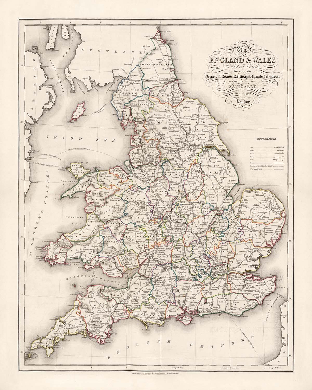
Entra nel mondo intricato della cartografia vittoriana con la "Mappa dell'Inghilterra e del Galles: Divisa in contee" di Samuel Lewis, un capolavoro pubblicato per la prima volta nel 1844. Questa mappa meticolosamente colorata a mano è stata creata per accompagnare il rinomato Dizionario Topografico di Lewis, un'opera di riferimento monumentale che cercava di catturare il paesaggio in continua evoluzione della Gran Bretagna del XIX secolo. Lo scopo originale della mappa era sia pratico che accademico: illuminare l'intricata patchwork di contee, confini amministrativi e rotte di trasporto che definivano la nazione all'alba dell'era ferroviaria. La sua leggenda dettagliata e le linee precise invitano l'osservatore a esplorare l'Inghilterra e il Galles di un'epoca passata, dove ogni confine di contea e via d'acqua era tracciato con cura e intenzione.
Samuel Lewis, il rinomato editore dietro questa mappa, era un cronista visionario della geografia britannica. Il suo Dizionario Topografico e l'atlante ad esso associato hanno stabilito nuovi standard di accuratezza e completezza in un'epoca di rapida trasformazione sociale e industriale. La mappa stessa è stata incisa dai capaci J. & C. Walker e disegnata da R. Creighton, entrambi celebri per la loro abilità tecnica e artisticità. La dedizione di Lewis alla chiarezza e all'utilità è evidente in ogni aspetto della mappa, dalle divisioni delle contee colorate a mano alla rappresentazione accurata di strade, ferrovie e canali—ognuno un'arteria vitale nella vita economica e culturale della Gran Bretagna vittoriana.
Questa mappa offre uno sguardo affascinante nel paesaggio fisico e amministrativo dell'Inghilterra e del Galles durante un periodo cruciale della storia. Le contee sono delineate in modo audace, con i loro confini evidenziati in colori vivaci, mentre il confine nazionale tra Inghilterra e Galles è chiaramente segnato. Fiumi principali come il Tamigi, il Severn, il Mersey e il Trent si snodano attraverso la mappa, fungendo sia da confini naturali che da vie di comunicazione per il commercio e i viaggi. Il Mare d'Irlanda, il Mare del Nord e il Canale di Bristol incorniciano la massa terrestre, mentre la costa è rappresentata con dettagli squisiti, catturando ogni baia, estuario e penisola.
La mappa è anche una celebrazione dell'insediamento umano e dei successi, tracciando le posizioni delle città e dei paesi più storici dell'Inghilterra e del Galles. Dalla metropoli vivace di Londra ai centri industriali di Birmingham, Manchester e Liverpool, ogni insediamento è posizionato con attenzione, riflettendo la sua importanza nel tessuto nazionale. Paesi più piccoli ma non meno significativi—York, Oxford, Cambridge, Exeter, Cardiff, Swansea e molti altri—sono anch'essi presenti, i cui nomi riecheggiano secoli di storia, cultura e identità locale. L'inclusione di ponti, canali e ferrovie precoci evidenzia ulteriormente lo spirito di innovazione e connettività dell'epoca.
Oltre alla sua precisione geografica, questa mappa rappresenta un testamento all'arte e all'ambizione della cartografia britannica del XIX secolo. Il rilievo è rappresentato attraverso delicate hachures, dando forma alle montagne e alle alture del Galles e dei Pennini, mentre il meridiano principale a Greenwich fornisce un ancoraggio moderno per la navigazione. Come una delle 57 mappe nell'celebrato atlante di Lewis, questo pezzo incapsula la curiosità intellettuale e la competenza tecnica dei suoi creatori. Non è semplicemente una mappa, ma un documento storico vibrante—un invito a viaggiare attraverso i paesaggi, i confini e le storie che hanno plasmato l'Inghilterra e il Galles vittoriani.
Città e paesi su questa mappa
- Inghilterra:
- Londra
- Birmingham
- Manchester
- Liverpool
- Leeds
- Sheffield
- Bristol
- Newcastle (Newcastle upon Tyne)
- Nottingham
- Leicester
- Portsmouth
- Southampton
- Plymouth
- Derby
- Stoke (Stoke-on-Trent)
- Sunderland
- Wolverhampton
- Reading
- Brighton
- Hull (Kingston upon Hull)
- Coventry
- Bradford
- Middlesbrough
- Northampton
- Luton
- Milton Keynes
- Norwich
- York
- Oxford
- Cambridge
- Exeter
- Gloucester
- Carlisle
- Chester
- Lincoln
- Bath
- Canterbury
- Hereford
- Salisbury
- Winchester
- Shrewsbury
- Worcester
- Durham
-
Lancaster
-
Galles:
- Cardiff
- Swansea
- Newport
- Wrexham
- Bangor
- St Asaph
- St Davids
- Brecon
- Carmarthen
- Haverfordwest
- Aberystwyth
Caratteristiche e monumenti notevoli
- I confini della contea sono chiaramente delineati con colorazione a mano.
- Il confine nazionale tra Inghilterra e Galles è segnato.
- Il Mare d'Irlanda, il Mare del Nord e il Canale di Bristol sono etichettati.
- I principali fiumi come il Tamigi, il Severn, il Mersey, il Trent e l'Humber sono mostrati.
- Il meridiano principale a Greenwich è indicato.
- Le hachures sono utilizzate per rappresentare aree di elevazione maggiore, specialmente in regioni come il Galles e i Pennini.
- Le strade principali e le prime ferrovie sono contrassegnate.
- I canali sono mostrati, riflettendo la loro importanza nei trasporti del XIX secolo.
- I ponti significativi sono contrassegnati nei punti chiave di attraversamento dei fiumi.
- È inclusa una spiegazione dettagliata o una legenda, chiarendo i simboli e le caratteristiche della mappa.
- Rappresentazione dettagliata della costa, comprese baie, estuari e penisole.
Contesto storico e di design
- Creato nel 1844 come parte del Dizionario Topografico di Samuel Lewis.
- Prodotto da Samuel Lewis & Co., Londra; inciso da J. & C. Walker e disegnato da R. Creighton.
- Progettato per illustrare le rotte di navigazione, le distanze e le caratteristiche geografiche significative.
- Copre i paesi di Inghilterra e Galles, divisi in contee.
- Colorato a mano e progettato per essere pieghevole per un uso pratico.
- Meridiano principale impostato a Greenwich, standardizzando i riferimenti di posizione.
- Riflette la comprensione della geografia, delle infrastrutture e dei modelli insediativi della metà del XIX secolo.
- Parte di un atlante più grande (57 mappe), fornendo una copertura completa di Inghilterra e Galles durante un periodo di significativo cambiamento sociale e industriale.
Si prega di controllare attentamente le immagini per assicurarsi che una specifica città o luogo sia mostrato su questa mappa. Puoi anche contattarci e chiedere di controllare la mappa per te.
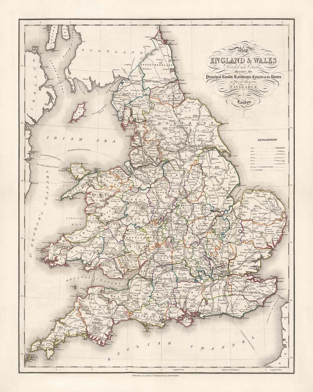
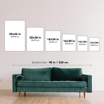
Questa mappa appare fantastica in ogni dimensione, ma consiglio sempre di optare per una dimensione più grande se hai spazio. In questo modo puoi facilmente distinguere tutti i dettagli.
Questa mappa appare incredibile in dimensioni fino a 70in (180cm). Se stai cercando una mappa più grande, per favore contattaci.
Il modello nelle immagini dell'elenco tiene la versione 16x20in (40x50cm) di questa mappa.
La quinta immagine dell'elenco mostra un esempio del mio servizio di personalizzazione della mappa.
Se stai cercando qualcosa di leggermente diverso, dai un'occhiata alla mia collezione delle migliori vecchie mappe per vedere se qualcosa attira la tua attenzione.
Per favore contattami per verificare se una certa posizione, punto di riferimento o caratteristica è mostrata su questa mappa.
Questo sarebbe un meraviglioso regalo per un compleanno, Natale, Festa del Papà, pensionamento, anniversario o per una festa di inaugurazione per qualcuno delle aree coperte da questa mappa.
Questa mappa è disponibile come stampa giclée su carta opaca archiviata senza acidi, oppure puoi acquistarla incorniciata. La cornice è una bella e semplice cornice nera che si adatta alla maggior parte degli stili. Per favore, mettiti in contatto se desideri un colore o un materiale della cornice diverso. Le mie cornici sono rivestite con acrilico museale super chiaro (perspex/acrylite), che è significativamente meno riflettente del vetro, più sicuro e arriverà sempre in perfette condizioni.
This map is also available as a float framed canvas, sometimes known as a shadow gap framed canvas or canvas floater. The map is printed on artist's cotton canvas and then stretched over a handmade box frame. We then "float" the canvas inside a wooden frame, which is available in a range of colours (black, dark brown, oak, antique gold and white). This is a wonderful way to present a map without glazing in front. See some examples of float framed canvas maps and explore the differences between my different finishes.
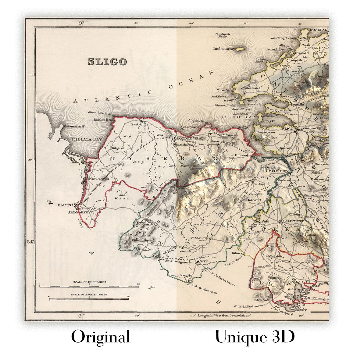
For something truly unique, this map is also available in "Unique 3D", our trademarked process that dramatically transforms the map so that it has a wonderful sense of depth. We combine the original map with detailed topography and elevation data, so that mountains and the terrain really "pop". For more info and examples of 3D maps, check my Unique 3D page.
For most orders, delivery time is about 3 working days. Personalised and customised products take longer, as I have to do the personalisation and send it to you for approval, which usually takes 1 or 2 days.
Please note that very large framed orders usually take longer to make and deliver.
If you need your order to arrive by a certain date, please contact me before you order so that we can find the best way of making sure you get your order in time.
I print and frame maps and artwork in 23 countries around the world. This means your order will be made locally, which cuts down on delivery time and ensures that it won't be damaged during delivery. You'll never pay customs or import duty, and we'll put less CO2 into the air.
All of my maps and art prints are well packaged and sent in a rugged tube if unframed, or surrounded by foam if framed.
I try to send out all orders within 1 or 2 days of receiving your order, though some products (like face masks, mugs and tote bags) can take longer to make.
If you select Express Delivery at checkout your order we will prioritise your order and send it out by 1-day courier (Fedex, DHL, UPS, Parcelforce).
Next Day delivery is also available in some countries (US, UK, Singapore, UAE) but please try to order early in the day so that we can get it sent out on time.
My standard frame is a gallery style black ash hardwood frame. It is simple and quite modern looking. My standard frame is around 20mm (0.8in) wide.
I use super-clear acrylic (perspex/acrylite) for the frame glass. It's lighter and safer than glass - and it looks better, as the reflectivity is lower.
Six standard frame colours are available for free (black, dark brown, dark grey, oak, white and antique gold). Custom framing and mounting/matting is available if you're looking for something else.
Most maps, art and illustrations are also available as a framed canvas. We use matte (not shiny) cotton canvas, stretch it over a sustainably sourced box wood frame, and then 'float' the piece within a wood frame. The end result is quite beautiful, and there's no glazing to get in the way.
All frames are provided "ready to hang", with either a string or brackets on the back. Very large frames will have heavy duty hanging plates and/or a mounting baton. If you have any questions, please get in touch.
See some examples of my framed maps and framed canvas maps.
Alternatively, I can also supply old maps and artwork on canvas, foam board, cotton rag and other materials.
If you want to frame your map or artwork yourself, please read my size guide first.
Alcune delle mie vecchie mappe sono ora disponibili come tele incorniciate. Per favore contattami se desideri ordinare una dimensione che non è disponibile nel mio negozio.
Le vecchie mappe su tela sono un'alternativa interessante alle mappe incorniciate in modo convenzionale. A seconda del tuo gusto personale e dell'arredamento della stanza, le mappe su tela possono "risaltare" un po' di più rispetto a una mappa incorniciata.
My maps are extremely high quality reproductions of original maps.
I source original, rare maps from libraries, auction houses and private collections around the world, restore them at my London workshop, and then use specialist giclée inks and printers to create beautiful maps that look even better than the original.
My maps are printed on acid-free archival matte (not glossy) paper that feels very high quality and almost like card. In technical terms the paper weight/thickness is 10mil/200gsm. It's perfect for framing.
I print with Epson ultrachrome giclée UV fade resistant pigment inks - some of the best inks you can find.
I can also make maps on canvas, cotton rag and other exotic materials.
Learn more about The Unique Maps Co.
Map personalisation
If you're looking for the perfect anniversary or housewarming gift, I can personalise your map to make it truly unique. For example, I can add a short message, or highlight an important location, or add your family's coat of arms.
The options are almost infinite. Please see my map personalisation page for some wonderful examples of what's possible.
To order a personalised map, select "personalise your map" before adding it to your basket.
Get in touch if you're looking for more complex customisations and personalisations.
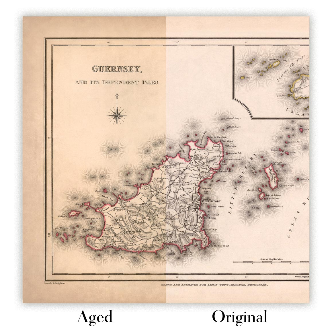
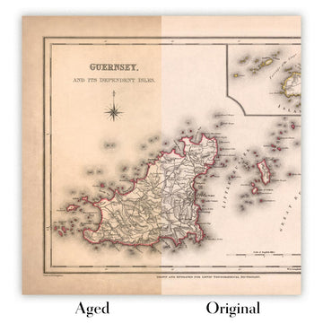
Map ageing
I have been asked hundreds of times over the years by customers if they could buy a map that looks even older.
Well, now you can, by selecting Aged before you add a map to your basket.
All the product photos you see on this page show the map in its Original form. This is what the map looks like today.
If you select Aged, I will age your map by hand, using a special and unique process developed through years of studying old maps, talking to researchers to understand the chemistry of aging paper, and of course... lots of practice!
If you're unsure, stick to the Original colour of the map. If you want something a bit darker and older looking, go for Aged.
Se non sei soddisfatto del tuo ordine per qualsiasi motivo, contattami per un rimborso senza problemi. Si prega di consultare la nostra politica di reso e rimborso per ulteriori informazioni.
Sono molto sicuro che ti piacerà la tua mappa restaurata o la stampa d'arte. Lo faccio dal 1984. Sono un venditore Etsy a 5 stelle. Ho venduto decine di migliaia di mappe e stampe d'arte e ho oltre 5.000 recensioni reali a 5 stelle.
Utilizzo un processo unico per restaurare mappe e opere d'arte che richiede molto tempo e lavoro. Trovare le mappe e le illustrazioni originali può richiedere mesi. Utilizzo tecnologia all'avanguardia e incredibilmente costosa per scannerizzare e restaurarle. Di conseguenza, garantisco che le mie mappe e stampe d'arte siano superiori alle altre - ecco perché posso offrire un rimborso senza problemi.
Quasi tutte le mie mappe e stampe d'arte sembrano fantastiche a grandi dimensioni (200 cm, 6,5 piedi+) e posso anche incorniciarle e consegnarle a te, tramite un corriere speciale per oggetti di grandi dimensioni. Contattami per discutere delle tue esigenze specifiche.
Or try searching for something!


