


Old Map of Harlem, NYC by Bromley, 1879: Central Park, 5th Ave, Lenox Ave, St. Nicholas Ave, 7th Ave

-
![]() Handmade in Australia
Handmade in Australia
-
FREE delivery in 3-4 days ⓘ
Free delivery in 3-4 days
Your map should be delivered in 3-4 working days with free delivery, worldwide.
Please use Express Delivery at checkout for Christmas orders. Framed orders may arrive with Express Delivery, but it is not guaranteed.
New for 2025: After you order, you can send a beautiful gift preview by email, if you're worried it won't arrive on time.
We make maps by hand locally in 23 countries, including Australia
![]() . If you're buying a gift for someone in another country, we will make the map locally to them.
. If you're buying a gift for someone in another country, we will make the map locally to them.You will never pay import tax or customs duty.
Check the Christmas delivery guide for order deadlines. Delivery times are starting to slow down, and will continue to slow down towards Christmas.
Express delivery is available at checkout which can reduce the delivery time to 1-2 days.
Please note that personalised maps, and larger framed maps, can take longer to produce and deliver.
If you need your order to arrive by a certain date, contact me and we can discuss your options.
-
FREE gift preview
ⓘ
Digital gift preview
New for 2025: After you complete your order, you can send a beautiful digital preview to the gift recipient. Just provide their email address and we'll do the rest. (Their email address will not be stored or used for any other purpose.)
This is perfect for Christmas gifting, particularly if you're concerned that your order might not arrive in time for Christmas.
-
90 day money back guarantee
ⓘ
90 days to return and refund
Products can be returned within 90 days for a full refund, or exchange for another product.
For personalised and custom made items, we may offer you store credit or a non-expiring gift card, as we cannot resell personalised orders.
If you have any questions, get in touch. For more information, see our full returns & exchanges policy.

My maps are rare, museum-grade, restored old maps sourced from libraries, auction houses and private collections across the globe.
Framing & free personalisation available
1. Select your size
2. Frame & personalise your map
There is limited framing & personalisation capacity available. Order by 10am tomorrow for Christmas delivery.


Gift message & custom finish

If you want to add a gift message, or a finish (jigsaw, aluminium board, etc.) that is not available here, please request it in the "order note" when you check out.
Every order is custom made, so if you need the size adjusted slightly, or printed on an unusual material, just let us know. We've done thousands of custom orders over the years, so there's (almost) nothing we can't manage.
You can also contact us before you order, if you prefer!

- Handmade locally. No import duty or tax
- FREE Delivery by Christmas
- Love it or your money back (90 days)
- Questions? WhatsApp me any time
Own a piece of history
5,000+ 5 star reviews


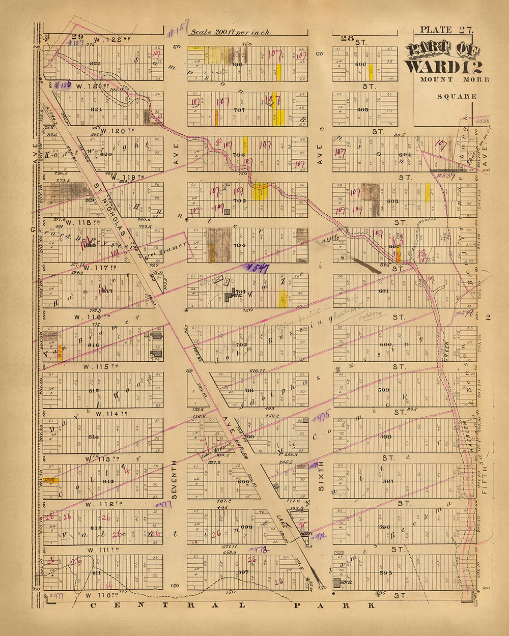
"Part of Ward 12, New York City," crafted by the esteemed cartographer G.W. Bromley in 1879, is a fascinating window into the urban landscape of late 19th-century Manhattan. This meticulously detailed map captures the intricate grid of streets and avenues that define Ward 12, offering a snapshot of a burgeoning metropolis on the cusp of modernity. Notably, it includes the northern edge of Central Park, an iconic landmark that has been a green oasis in the city since its creation in the mid-1800s. The map's precision and clarity reflect Bromley's commitment to accuracy and his expertise in urban cartography.
The map is not just a representation of streets and blocks; it is a historical document that reveals the layout and development patterns of New York City during a pivotal era. Each street, from 110th to 128th, and avenues such as Lenox, St. Nicholas, and 7th, are meticulously plotted, showcasing the city's methodical expansion. The inclusion of significant thoroughfares like 5th Avenue and 6th Avenue highlights the importance of these routes in the city's transportation network, which facilitated commerce and daily life.
G.W. Bromley, renowned for his detailed atlases, brought a level of precision to his work that makes this map an invaluable resource for historians and enthusiasts alike. His maps were known for their accuracy and attention to detail, providing a comprehensive view of urban areas that were rapidly changing. This map of Ward 12 is no exception, offering insights into property divisions, building footprints, and the urban grid that shaped the daily lives of New Yorkers in the late 19th century.
One of the most compelling aspects of this map is its depiction of Central Park, a landmark that has been central to New York City's identity. The park's inclusion at the bottom of the map serves as a reminder of the city's commitment to providing green spaces amidst the urban sprawl. This juxtaposition of natural and built environments underscores the city's dynamic growth and the foresight of its planners.
In addition to its historical significance, the map's design reflects the cartographic style of the period, with its clear labeling and use of color to distinguish different areas. This aesthetic quality, combined with its detailed content, makes it a captivating piece for collectors and history buffs. Owning this map is not just about possessing a piece of paper; it is about holding a fragment of New York City's storied past, a testament to the city's enduring spirit and relentless growth.
Streets and roads on this map
- 110th St.
- 111th St.
- 112th St.
- 113th St.
- 114th St.
- 115th St.
- 116th St.
- 117th St.
- 118th St.
- 119th St.
- 120th St.
- 121st St.
- 122nd St.
- 123rd St.
- 124th St.
- 125th St.
- 126th St.
- 127th St.
- 128th St.
- 6th Ave.
- 7th Ave.
- 5th Ave.
- Lenox Ave.
- Manhattan Ave.
- St. Nicholas Ave.
Notable Features & Landmarks
- Central Park (visible at the bottom of the map)
Historical and design context
- Name of the map: Part of Ward 12, New York City
- When the map was made: 1879
- Mapmaker or publisher: G.W. Bromley
- Interesting context about the mapmaker: G.W. Bromley was known for creating detailed atlases and maps of urban areas, particularly in the northeastern United States. His works are valuable resources for historical and genealogical research.
- Topics and themes shown on the map:
- Urban planning and development in New York City during the late 19th century.
- Detailed layout of streets, blocks, and plots within Ward 12.
- The map provides insights into the city’s infrastructure and property divisions at that time.
- Countries and regions shown on the map: United States, specifically part of New York City.
- Context about the design or style of the map:
- The map features a detailed grid layout typical of urban planning maps.
- Use of color and labels to distinguish different types of buildings and plots.
- The design reflects the cartographic style of the late 19th century, focusing on precision and detail.
- Historical significance or context of the map:
- The map is a valuable historical document that offers insights into the urban development and property distribution in New York City during the late 1800s.
- It helps researchers understand the city’s growth patterns and the evolution of its neighborhoods.
Please double check the images to make sure that a specific town or place is shown on this map. You can also get in touch and ask us to check the map for you.
This map looks great at every size, but I always recommend going for a larger size if you have space. That way you can easily make out all of the details.
This map looks amazing at sizes all the way up to 70in (180cm). If you are looking for a larger map, please get in touch.
The model in the listing images is holding the 16x20in (40x50cm) version of this map.
The fifth listing image shows an example of my map personalisation service.
If you’re looking for something slightly different, check out my collection of the best old maps to see if something else catches your eye.
Please contact me to check if a certain location, landmark or feature is shown on this map.
This would make a wonderful birthday, Christmas, Father's Day, work leaving, anniversary or housewarming gift for someone from the areas covered by this map.
This map is available as a giclée print on acid free archival matte paper, or you can buy it framed. The frame is a nice, simple black frame that suits most aesthetics. Please get in touch if you'd like a different frame colour or material. My frames are glazed with super-clear museum-grade acrylic (perspex/acrylite), which is significantly less reflective than glass, safer, and will always arrive in perfect condition.
This map is also available as a float framed canvas, sometimes known as a shadow gap framed canvas or canvas floater. The map is printed on artist's cotton canvas and then stretched over a handmade box frame. We then "float" the canvas inside a wooden frame, which is available in a range of colours (black, dark brown, oak, antique gold and white). This is a wonderful way to present a map without glazing in front. See some examples of float framed canvas maps and explore the differences between my different finishes.
For something truly unique, this map is also available in "Unique 3D", our trademarked process that dramatically transforms the map so that it has a wonderful sense of depth. We combine the original map with detailed topography and elevation data, so that mountains and the terrain really "pop". For more info and examples of 3D maps, check my Unique 3D page.
For most orders, delivery time is about 3 working days. Personalised and customised products take longer, as I have to do the personalisation and send it to you for approval, which usually takes 1 or 2 days.
Please note that very large framed orders usually take longer to make and deliver.
If you need your order to arrive by a certain date, please contact me before you order so that we can find the best way of making sure you get your order in time.
I print and frame maps and artwork in 23 countries around the world. This means your order will be made locally, which cuts down on delivery time and ensures that it won't be damaged during delivery. You'll never pay customs or import duty, and we'll put less CO2 into the air.
All of my maps and art prints are well packaged and sent in a rugged tube if unframed, or surrounded by foam if framed.
I try to send out all orders within 1 or 2 days of receiving your order, though some products (like face masks, mugs and tote bags) can take longer to make.
If you select Express Delivery at checkout your order we will prioritise your order and send it out by 1-day courier (Fedex, DHL, UPS, Parcelforce).
Next Day delivery is also available in some countries (US, UK, Singapore, UAE) but please try to order early in the day so that we can get it sent out on time.
My standard frame is a gallery style black ash hardwood frame. It is simple and quite modern looking. My standard frame is around 20mm (0.8in) wide.
I use super-clear acrylic (perspex/acrylite) for the frame glass. It's lighter and safer than glass - and it looks better, as the reflectivity is lower.
Six standard frame colours are available for free (black, dark brown, dark grey, oak, white and antique gold). Custom framing and mounting/matting is available if you're looking for something else.
Most maps, art and illustrations are also available as a framed canvas. We use matte (not shiny) cotton canvas, stretch it over a sustainably sourced box wood frame, and then 'float' the piece within a wood frame. The end result is quite beautiful, and there's no glazing to get in the way.
All frames are provided "ready to hang", with either a string or brackets on the back. Very large frames will have heavy duty hanging plates and/or a mounting baton. If you have any questions, please get in touch.
See some examples of my framed maps and framed canvas maps.
Alternatively, I can also supply old maps and artwork on canvas, foam board, cotton rag and other materials.
If you want to frame your map or artwork yourself, please read my size guide first.
My maps are extremely high quality reproductions of original maps.
I source original, rare maps from libraries, auction houses and private collections around the world, restore them at my London workshop, and then use specialist giclée inks and printers to create beautiful maps that look even better than the original.
My maps are printed on acid-free archival matte (not glossy) paper that feels very high quality and almost like card. In technical terms the paper weight/thickness is 10mil/200gsm. It's perfect for framing.
I print with Epson ultrachrome giclée UV fade resistant pigment inks - some of the best inks you can find.
I can also make maps on canvas, cotton rag and other exotic materials.
Learn more about The Unique Maps Co.
Map personalisation
If you're looking for the perfect anniversary or housewarming gift, I can personalise your map to make it truly unique. For example, I can add a short message, or highlight an important location, or add your family's coat of arms.
The options are almost infinite. Please see my map personalisation page for some wonderful examples of what's possible.
To order a personalised map, select "personalise your map" before adding it to your basket.
Get in touch if you're looking for more complex customisations and personalisations.
Map ageing
I have been asked hundreds of times over the years by customers if they could buy a map that looks even older.
Well, now you can, by selecting Aged before you add a map to your basket.
All the product photos you see on this page show the map in its Original form. This is what the map looks like today.
If you select Aged, I will age your map by hand, using a special and unique process developed through years of studying old maps, talking to researchers to understand the chemistry of aging paper, and of course... lots of practice!
If you're unsure, stick to the Original colour of the map. If you want something a bit darker and older looking, go for Aged.
If you are not happy with your order for any reason, contact me and I'll get it fixed ASAP, free of charge. Please see my returns and refund policy for more information.
I am very confident you will like your restored map or art print. I have been doing this since 1984. I'm a 5-star Etsy seller. I have sold tens of thousands of maps and art prints and have over 5,000 real 5-star reviews. My work has been featured in interior design magazines, on the BBC, and on the walls of dozens of 5-star hotels.
I use a unique process to restore maps and artwork that is massively time consuming and labour intensive. Hunting down the original maps and illustrations can take months. I use state of the art and eye-wateringly expensive technology to scan and restore them. As a result, I guarantee my maps and art prints are a cut above the rest. I stand by my products and will always make sure you're 100% happy with what you receive.
Almost all of my maps and art prints look amazing at large sizes (200cm, 6.5ft+) and I can frame and deliver them to you as well, via special oversized courier. Contact me to discuss your specific needs.
Or try searching for something!


