


Old Map of Uttarakhand Pilgrimage by Singh, 1960: Chota Char Dham, Mt. Kailash, Ganges Myth, Badrinath, Kedarnath
Buy 2, Get 1 More Free
If you add 2 items to your bag, you can add a third product for free. The discount is automatic - no code required.
This is equivalent to 33% off, which will be the largest discount available on my shop this year.
This works for all maps and artwork. You can order 3 of the same thing, or 3 different things.
Custom maps are excluded, as they're too time consuming to make and we'd prefer to take our time rather than rush through a lot of orders.
Contact me if you have any questions.
-
![]() Handmade in Australia
Handmade in Australia

-
FREE worldwide delivery in 2-3 days ⓘ
Free delivery in 2-3 days
Your map should be delivered in 2-3 working days with free delivery, worldwide.
We make maps by hand locally in 23 countries, including Australia
![]() . If you're buying a gift for someone in another country, we will make the map locally to them.
. If you're buying a gift for someone in another country, we will make the map locally to them.You will never pay import tax or customs duty.
Express delivery is available at checkout which can reduce the delivery time to 1-2 days.
Please note that personalised maps, and larger framed maps, can take longer to produce and deliver.
If you need your order to arrive by a certain date, contact me and we can discuss your options.
-
Complimentary gifting & design advice
ⓘ
Complimentary gifting & design advice
Available almost 24/7 on WhatsApp and email — we usually reply within minutes. We can help you:
- Choose a perfectly personalised gift
- Send a digital gift preview to the recipient
- Pick the ideal size for your wall
- Select the right finish and frame
Quick, friendly advice so you can order with confidence.
For last minute gifts, consider buying a digital gift card. We have over 5,000 maps and art prints to choose from.
-
90-day returns & 5-year guarantee
ⓘ
90-day returns & 5-year guarantee
Products can be returned within 90 days for a full refund, or exchange for another product.
We are also proud to offer a 5-year quality guarantee on our maps and art, covering defects in materials or workmanship under normal use.
For personalised and custom made items, we may offer you store credit or a non-expiring gift card, as we cannot resell personalised orders.
If you have any questions, get in touch. For more information, see our full returns & exchanges policy.

This is a museum-grade archival print from the original 1960 map — restored in our workshop and made to order on 220gsm archival matte paper or 400gsm artist's cotton canvas with pigment inks.
Professional framing & free personalisation available.
1. Choose a size
2. Frame & personalise your map
Make your map unique with framing, hand-drawn customisation, vintage ageing, pop art text, unique 3D styling and more.


Gift message & custom finish

If you want to add a gift message, or a finish (jigsaw, aluminium board, etc.) that is not available here, please request it in the "order note" when you check out.
Every order is custom made, so if you need the size adjusted slightly, or printed on an unusual material, just let us know. We've done thousands of custom orders over the years, so there's (almost) nothing we can't manage.
You can also contact us before you order, if you prefer!

- Handmade locally. No import duty or tax
- FREE worldwide delivery
- 90-day returns & 5-year product guarantee
- Questions? WhatsApp me any time
Own a piece of history
7,000+ 5 star reviews


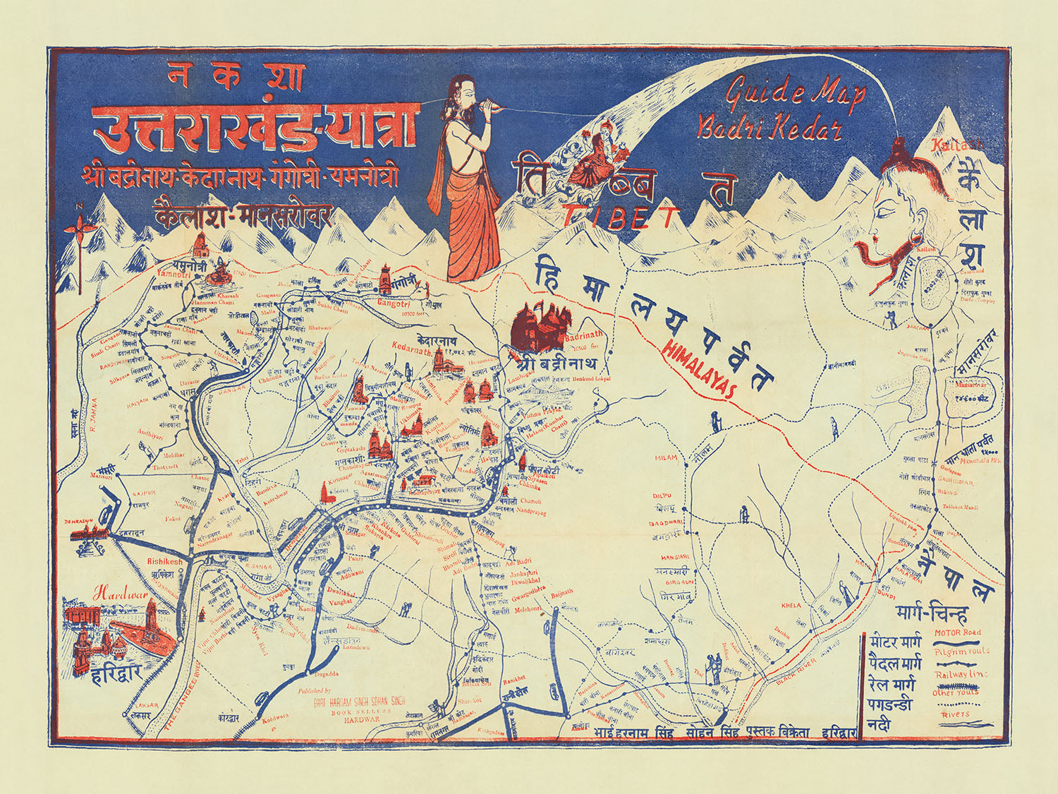
The "Guide Map Badri Kedar," created by Bhai Harnam Singh Sohan Singh in 1960, is a captivating infographic and pictorial map that serves as a pilgrimage guide for the Uttarakhand region of India. This map meticulously illustrates the sacred routes of the Chota Char Dham pilgrimage circuit, encompassing the revered sites of Badrinath, Kedarnath, Gangotri, and Yamnotri. It also extends to include the holy routes to Mt. Kailash and Lake Mansarovar, significant to multiple religions. The map's dual-language format in Hindi and English ensures accessibility for a diverse audience, enhancing its historical and cultural value.
The map is a visual feast, with detailed illustrations of cities, temples, and pilgrimage routes. Each location is depicted according to its size and significance, making the map not only informative but also visually engaging. The inclusion of figures of pilgrims along the routes emphasizes the spiritual journey and the importance of these paths. The legend at the bottom right provides clear symbols for motor roads, pilgrim routes, railroads, and rivers, ensuring that the map is easy to navigate.
One of the most striking features of this map is the allegorical depiction of the Hindu goddess Ganga’s descent to Earth to form the Ganges River, located in the top right section. This mythological illustration adds a layer of depth and storytelling to the map, highlighting the rich cultural and religious heritage of the region. The depiction of Mt. Kailash, alongside a large illustration of Lord Shiva, further underscores the map's spiritual significance.
Bhai Harnam Singh Sohan Singh, the mapmaker, has skillfully combined cartographic precision with artistic elements to create a map that is both a practical guide and a work of art. His choice to publish this map in Haridwar, one of the seven holy cities in Hinduism, adds to its authenticity and relevance. The map not only serves as a guide for pilgrims but also as a historical document that captures the essence of Uttarakhand, often referred to as “the playground of the Gods.”
The "Guide Map Badri Kedar" is more than just a map; it is a window into the spiritual and cultural landscape of Uttarakhand. It offers a unique blend of geographical information and mythological storytelling, making it a valuable piece for collectors and enthusiasts of historical maps. This map is a testament to the enduring significance of pilgrimage in Indian culture and the timeless beauty of the Himalayan region.
Places on this map
- Haridwar: Located in the bottom left corner.
- Rishikesh: Shown near Haridwar.
- Badrinath: Illustrated prominently.
- Kedarnath: Clearly marked.
- Gangotri: Included on the pilgrimage route.
- Yamnotri: Part of the Chota Char Dham circuit.
- Mt. Kailash: Illustrated at the top right.
- Lake Mansarovar: Shown near Mt. Kailash.
- Himalayas: Denoted at the top of the map.
- Ganges River: Depicted through its mythological creation.
- Tibet: Shown at the top right.
- Motor roads, pilgrim routes, railroads, and rivers: Indicated with specific symbols in the legend.
Notable Features & Landmarks
- Himalayan mountain range: Illustrated prominently at the top.
- North arrow illustration: Located at the top left.
- Depiction of the Ganges River creation myth: Featuring King Bhagiratha, the goddess Ganga, and Lord Shiva.
- Mt. Kailash: Illustrated at the top right with a large depiction of Shiva.
- Cities and temples: Illustrated according to size and characteristics.
- Pilgrimage routes: Clearly marked with figures of pilgrims.
- Legend: Located at the bottom right, denoting motor roads, pilgrim routes, railroads, and rivers.
- Illustrations of holy sites: Including Badrinath, Kedarnath, Gangotri, and Yamnotri.
- Visual emphasis on pilgrimage: Routes and important religious locations.
- Historical and cultural context: Depicts the Uttarakhand region's spiritual and mythological significance.
Historical and design context
- Name of the map: Guide Map Badri Kedar
- Creation date: 1960
- Mapmaker/Publisher: Bhai Harnam Singh Sohan Singh
- Interesting context about the mapmaker: Published in Haridwar, a significant holy city in Hinduism.
- Type of map: Infographic Thematic and Pictorial map
- Topics and themes shown on the map:
- Pilgrimage routes: Chota Char Dham pilgrimage circuit including Badrinath, Kedarnath, Gangotri, and Yamnotri.
- Holy sites: Routes to Mt. Kailash and Lake Mansarovar, sacred to multiple religions.
- Mythological depiction: Allegorical depiction of the Hindu goddess Ganga’s descent to form the Ganges River.
- Countries and regions shown on the map:
- India: Focus on the Uttarakhand region, north and east of Haridwar.
- Tibet: Shown at the top right.
- Design and style:
- Languages: Hindi and English.
- Visual elements: Illustrations of cities, temples, pilgrims, and mythological figures.
- Legend: Symbols for motor roads, pilgrim routes, railroads, rivers.
- Historical significance/context:
- Religious importance: Emphasizes the spiritual significance of Uttarakhand, referred to as “the playground of the Gods.”
- Cultural heritage: Reflects the rich mythological and religious traditions of the region.
Please double check the images to make sure that a specific town or place is shown on this map. You can also get in touch and ask us to check the map for you.
This map looks great at every size, but I always recommend going for a larger size if you have space. That way you can easily make out all of the details.
This map looks amazing at sizes all the way up to 70in (180cm). If you are looking for a larger map, please get in touch.
The model in the listing images is holding the 18x24in (45x60cm) version of this map.
The fifth listing image shows an example of my map personalisation service.
If you’re looking for something slightly different, check out my collection of the best old maps to see if something else catches your eye.
Please contact me to check if a certain location, landmark or feature is shown on this map.
This would make a wonderful birthday, Christmas, Father's Day, work leaving, anniversary or housewarming gift for someone from the areas covered by this map.
This map is available as a giclée print on acid free archival matte paper, or you can buy it framed. The frame is a nice, simple black frame that suits most aesthetics. Please get in touch if you'd like a different frame colour or material. My frames are glazed with super-clear museum-grade acrylic (perspex/acrylite), which is significantly less reflective than glass, safer, and will always arrive in perfect condition.
This map is also available as a float framed canvas, sometimes known as a shadow gap framed canvas or canvas floater. The map is printed on artist's cotton canvas and then stretched over a handmade box frame. We then "float" the canvas inside a wooden frame, which is available in a range of colours (black, dark brown, oak, antique gold and white). This is a wonderful way to present a map without glazing in front. See some examples of float framed canvas maps and explore the differences between my different finishes.
For something truly unique, this map is also available in "Unique 3D", our trademarked process that dramatically transforms the map so that it has a wonderful sense of depth. We combine the original map with detailed topography and elevation data, so that mountains and the terrain really "pop". For more info and examples of 3D maps, check my Unique 3D page.
For most orders, delivery time is about 3 working days. Personalised and customised products take longer, as I have to do the personalisation and send it to you for approval, which usually takes 1 or 2 days.
Please note that very large framed orders usually take longer to make and deliver.
If you need your order to arrive by a certain date, please contact me before you order so that we can find the best way of making sure you get your order in time.
I print and frame maps and artwork in 23 countries around the world. This means your order will be made locally, which cuts down on delivery time and ensures that it won't be damaged during delivery. You'll never pay customs or import duty, and we'll put less CO2 into the air.
All of my maps and art prints are well packaged and sent in a rugged tube if unframed, or surrounded by foam if framed.
I try to send out all orders within 1 or 2 days of receiving your order, though some products (like face masks, mugs and tote bags) can take longer to make.
If you select Express Delivery at checkout your order we will prioritise your order and send it out by 1-day courier (Fedex, DHL, UPS, Parcelforce).
Next Day delivery is also available in some countries (US, UK, Singapore, UAE) but please try to order early in the day so that we can get it sent out on time.
My standard frame is a gallery style black ash hardwood frame. It is simple and quite modern looking. My standard frame is around 20mm (0.8in) wide.
I use super-clear acrylic (perspex/acrylite) for the frame glass. It's lighter and safer than glass - and it looks better, as the reflectivity is lower.
Six standard frame colours are available for free (black, dark brown, dark grey, oak, white and antique gold). Custom framing and mounting/matting is available if you're looking for something else.
Most maps, art and illustrations are also available as a framed canvas. We use matte (not shiny) cotton canvas, stretch it over a sustainably sourced box wood frame, and then 'float' the piece within a wood frame. The end result is quite beautiful, and there's no glazing to get in the way.
All frames are provided "ready to hang", with either a string or brackets on the back. Very large frames will have heavy duty hanging plates and/or a mounting baton. If you have any questions, please get in touch.
See some examples of my framed maps and framed canvas maps.
Alternatively, I can also supply old maps and artwork on canvas, foam board, cotton rag and other materials.
If you want to frame your map or artwork yourself, please read my size guide first.
My maps are extremely high quality reproductions of original maps.
I source original, rare maps from libraries, auction houses and private collections around the world, restore them at my London workshop, and then use specialist giclée inks and printers to create beautiful maps that look even better than the original.
My maps are printed on acid-free archival matte (not glossy) paper that feels very high quality and almost like card. In technical terms the paper weight/thickness is 10mil/200gsm. It's perfect for framing.
I print with Epson ultrachrome giclée UV fade resistant pigment inks - some of the best inks you can find.
I can also make maps on canvas, cotton rag and other exotic materials.
Learn more about The Unique Maps Co.
Map personalisation
If you're looking for the perfect anniversary or housewarming gift, I can personalise your map to make it truly unique. For example, I can add a short message, or highlight an important location, or add your family's coat of arms.
The options are almost infinite. Please see my map personalisation page for some wonderful examples of what's possible.
To order a personalised map, select "personalise your map" before adding it to your basket.
Get in touch if you're looking for more complex customisations and personalisations.
Map ageing
I have been asked hundreds of times over the years by customers if they could buy a map that looks even older.
Well, now you can, by selecting Aged before you add a map to your basket.
All the product photos you see on this page show the map in its Original form. This is what the map looks like today.
If you select Aged, I will age your map by hand, using a special and unique process developed through years of studying old maps, talking to researchers to understand the chemistry of aging paper, and of course... lots of practice!
If you're unsure, stick to the Original colour of the map. If you want something a bit darker and older looking, go for Aged.
If you are not happy with your order for any reason, contact me and I'll get it fixed ASAP, free of charge. Please see my returns and refund policy for more information.
I am very confident you will like your restored map or art print. I have been doing this since 1984. I'm a 5-star Etsy seller. I have sold tens of thousands of maps and art prints and have over 5,000 real 5-star reviews. My work has been featured in interior design magazines, on the BBC, and on the walls of dozens of 5-star hotels.
I use a unique process to restore maps and artwork that is massively time consuming and labour intensive. Hunting down the original maps and illustrations can take months. I use state of the art and eye-wateringly expensive technology to scan and restore them. As a result, I guarantee my maps and art prints are a cut above the rest. I stand by my products and will always make sure you're 100% happy with what you receive.
Almost all of my maps and art prints look amazing at large sizes (200cm, 6.5ft+) and I can frame and deliver them to you as well, via special oversized courier. Contact me to discuss your specific needs.
Or try searching for something!


