

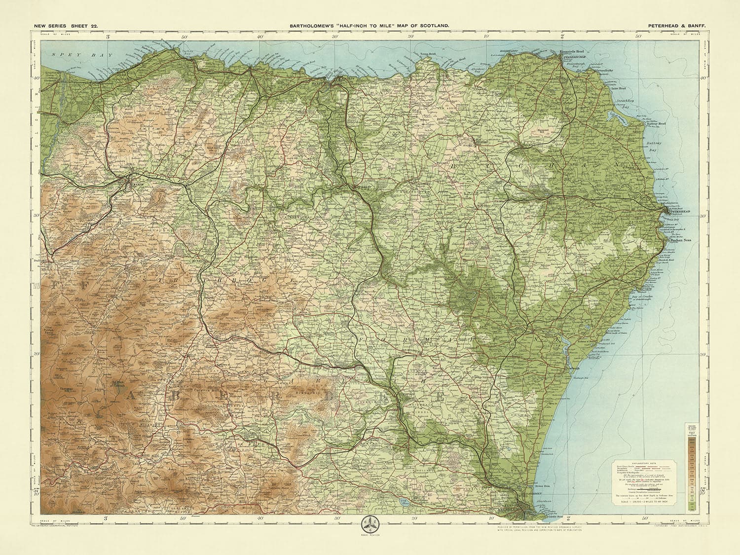


Old OS Map of Peterhead & Banff, Aberdeenshire by Bartholomew, 1901: Aberdeen, River Dee, Bennachie, Slains Castle, Fyvie Castle

-
![]() Handmade in Australia
Handmade in Australia
-
Christmas delivery: check the deadline
Free delivery in 3-4 days
Your map should be delivered in 3-4 working days with free delivery, worldwide.
We make maps by hand locally in 23 countries, including Australia
![]() . If you're buying a gift for someone in another country, we will make the map locally to them.
. If you're buying a gift for someone in another country, we will make the map locally to them.You will never pay import tax or customs duty.
Check the Christmas delivery guide for order deadlines. Delivery times are starting to slow down, and will continue to slow down towards Christmas.
Express delivery is available at checkout which can reduce the delivery time to 1-2 days.
Please note that personalised maps, and larger framed maps, can take longer to produce and deliver.
If you need your order to arrive by a certain date, contact me and we can discuss your options.
-
90 day money back guarantee
ⓘ
90 days to return and refund
Products can be returned within 90 days for a full refund, or exchange for another product.
For personalised and custom made items, we may offer you store credit or a non-expiring gift card, as we cannot resell personalised orders.
If you have any questions, get in touch. For more information, see our full returns & exchanges policy.

My maps are rare, museum-grade, restored old maps sourced from libraries, auction houses and private collections across the globe.
Framing & free personalisation available
1. Select your size
2. Frame & personalise your map
There is limited framing & personalisation capacity available. Order by 10am tomorrow for Christmas delivery.


Gift message & custom finish

If you want to add a gift message, or a finish (jigsaw, aluminium board, etc.) that is not available here, please request it in the "order note" when you check out.
Every order is custom made, so if you need the size adjusted slightly, or printed on an unusual material, just let us know. We've done thousands of custom orders over the years, so there's (almost) nothing we can't manage.
You can also contact us before you order, if you prefer!

- Handmade locally. No import duty or tax
- FREE Delivery by Christmas
- Love it or your money back (90 days)
- Questions? WhatsApp me any time
Own a piece of history
5,000+ 5 star reviews


Step into the past with the exquisite "Sheet 22 - Peterhead & Banff," a masterful creation by the renowned cartographer JG Bartholomew, dated 1901. This map is a testament to Bartholomew's unparalleled expertise and artistic vision, capturing the essence of the early 20th-century Scottish landscape. With its meticulous detailing and vibrant colours, this map was a flagship piece in Bartholomew's celebrated half-inch to the mile series, beloved by cyclists and tourists alike. The map's innovative use of colour gradation to depict elevation and terrain offers a vivid, almost three-dimensional view of the region, making it both a functional tool and a work of art.
Bartholomew's map provides a rich tapestry of the Peterhead and Banff regions, showcasing a diverse array of natural and man-made features. The detailed representation of rivers such as the Deveron, Ythan, Don, and Dee, alongside the prominent coastal features of the Moray Firth and North Sea coast, paints a comprehensive picture of the area's waterways. The map also highlights significant forests like the Forest of Deer and Durris Forest, as well as notable hills and mountains including Bennachie, Hill of Fare, and Tap o' Noth, offering a glimpse into the region's varied topography.
The historical significance of this map extends beyond its geographical features. It includes notable historical sites such as Slains Castle, Fyvie Castle, Huntly Castle, and Craigievar Castle, each steeped in rich history and architectural grandeur. These landmarks, carefully marked on the map, provide a window into Scotland's storied past, making this map not just a navigational aid but also a historical document. The presence of these castles and other historical sites underscores the cultural and historical depth of the region, inviting exploration and discovery.
In addition to its historical landmarks, the map is a testament to the era's burgeoning transportation network. The Great North of Scotland Railway and Highland Railway are prominently featured, reflecting the period's industrial advancements and the growing importance of connectivity. These railways, along with the detailed depiction of roads and pathways, highlight the map's utility for travelers and adventurers of the time. The map's intricate design and comprehensive detail make it an invaluable resource for understanding the early 20th-century Scottish landscape and infrastructure.
Bartholomew's "Sheet 22 - Peterhead & Banff" is more than just a map; it is a piece of history, a work of art, and a testament to the cartographer's skill and vision. It captures the essence of a bygone era, offering a detailed and vibrant portrayal of the region's natural beauty, historical landmarks, and evolving infrastructure. Whether you are a history enthusiast, a lover of fine cartography, or simply someone who appreciates the beauty of the Scottish landscape, this map is a timeless treasure that will enrich your understanding and appreciation of the past.
Cities and towns on this map
- Aberdeenshire:
- Aberdeen
- Peterhead
- Fraserburgh
- Inverurie
- Ellon
- Huntly
- Turriff
- Oldmeldrum
- Banff
- Macduff
- Portsoy
- Cullen
- Keith
- Ballater
- Aboyne
- Banchory
- Stonehaven
- Laurencekirk
- Insch
- Alford
- Westhill
- Newburgh
- Cruden Bay
- Mintlaw
- Maud
- New Pitsligo
- Strichen
- Rosehearty
- Gardenstown
- Whitehills
- Portknockie
- Findochty
- Buckie
- Fochabers
- Dufftown
- Aberchirder
- Cuminestown
- New Deer
- Fyvie
- Tarves
- Methlick
- Newmachar
- Kintore
- Blackburn
- Balmedie
- Cove Bay
- Portlethen
- Newtonhill
- Inverbervie
- St. Cyrus
Notable Features & Landmarks
- Rivers and Water Bodies:
- River Deveron
- River Ythan
- River Don
- River Dee
- Loch of Strathbeg
- Loch of Skene
- Forests and Woodlands:
- Forest of Deer
- Durris Forest
- Hills and Mountains:
- Bennachie
- Hill of Fare
- Knock Hill
- Tap o' Noth
- Coastal Features:
- Moray Firth
- North Sea coast
- Spey Bay
- Transportation:
- Great North of Scotland Railway
- Highland Railway
- Historical Sites:
- Slains Castle
- Fyvie Castle
- Huntly Castle
- Craigievar Castle
Historical and design context
- Scale and purpose: A clear, attractive, and colourful map at the half-inch to the mile scale (1:126,720). These maps were popular with cyclists and tourists, and became Bartholomew's flagship series.
- Relief representation: The half-inch maps were distinctive for using different layers of colour to represent landscape relief, with a subtle and innovative gradation of colour bands used to show land at different heights.
- Source: The map is based on a reduced Ordnance Survey map from the same period.
- Date of creation: 1901
- Mapmaker or publisher: JG Bartholomew
- Context about the mapmaker: John George Bartholomew was a renowned Scottish cartographer known for his detailed and aesthetically pleasing maps. His work significantly contributed to the field of cartography.
- Topics and themes shown on the map:
- Political and physical features: The map details political boundaries and physical landscapes, including elevation and terrain.
- Tourism and cycling: Reflecting the popularity of cycling and tourism during the early 20th century.
- Countries and regions shown on the map: This map covers parts of Scotland, specifically the regions around Peterhead and Banff.
- Design or style: The map features a landscape orientation and employs a layered colour scheme to depict elevation and terrain, enhancing its readability and aesthetic appeal.
- Historical significance: This map is a valuable historical document, reflecting early 20th-century cartographic techniques and the socio-cultural context of the time, particularly the burgeoning interest in outdoor activities like cycling and tourism.
Please double check the images to make sure that a specific town or place is shown on this map. You can also get in touch and ask us to check the map for you.
This map looks great at every size, but I always recommend going for a larger size if you have space. That way you can easily make out all of the details.
This map looks amazing at sizes all the way up to 70in (180cm). If you are looking for a larger map, please get in touch.
Please note: the labels on this map are hard to read if you order a map that is 20in (50cm) or smaller. The map is still very attractive, but if you would like to read the map easily, please buy a larger size.
The model in the listing images is holding the 18x24in (45x60cm) version of this map.
The fifth listing image shows an example of my map personalisation service.
If you’re looking for something slightly different, check out my collection of the best old maps to see if something else catches your eye.
Please contact me to check if a certain location, landmark or feature is shown on this map.
This would make a wonderful birthday, Christmas, Father's Day, work leaving, anniversary or housewarming gift for someone from the areas covered by this map.
This map is available as a giclée print on acid free archival matte paper, or you can buy it framed. The frame is a nice, simple black frame that suits most aesthetics. Please get in touch if you'd like a different frame colour or material. My frames are glazed with super-clear museum-grade acrylic (perspex/acrylite), which is significantly less reflective than glass, safer, and will always arrive in perfect condition.
This map is also available as a float framed canvas, sometimes known as a shadow gap framed canvas or canvas floater. The map is printed on artist's cotton canvas and then stretched over a handmade box frame. We then "float" the canvas inside a wooden frame, which is available in a range of colours (black, dark brown, oak, antique gold and white). This is a wonderful way to present a map without glazing in front. See some examples of float framed canvas maps and explore the differences between my different finishes.
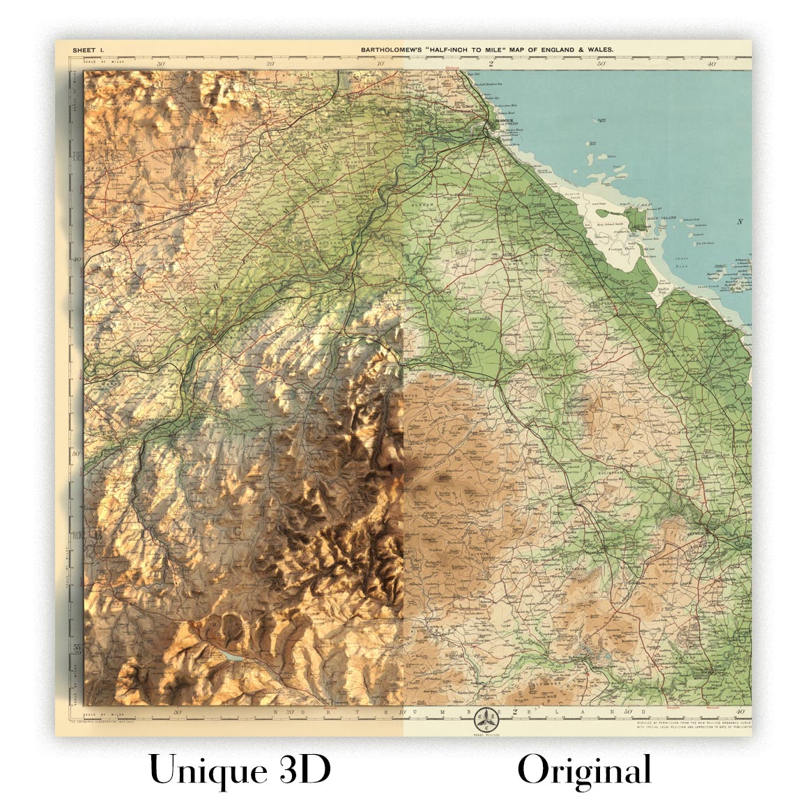
For something truly unique, this map is also available in "Unique 3D", our trademarked process that dramatically transforms the map so that it has a wonderful sense of depth. We combine the original map with detailed topography and elevation data, so that mountains and the terrain really "pop". For more info and examples of 3D maps, check my Unique 3D page.
For most orders, delivery time is about 3 working days. Personalised and customised products take longer, as I have to do the personalisation and send it to you for approval, which usually takes 1 or 2 days.
Please note that very large framed orders usually take longer to make and deliver.
If you need your order to arrive by a certain date, please contact me before you order so that we can find the best way of making sure you get your order in time.
I print and frame maps and artwork in 23 countries around the world. This means your order will be made locally, which cuts down on delivery time and ensures that it won't be damaged during delivery. You'll never pay customs or import duty, and we'll put less CO2 into the air.
All of my maps and art prints are well packaged and sent in a rugged tube if unframed, or surrounded by foam if framed.
I try to send out all orders within 1 or 2 days of receiving your order, though some products (like face masks, mugs and tote bags) can take longer to make.
If you select Express Delivery at checkout your order we will prioritise your order and send it out by 1-day courier (Fedex, DHL, UPS, Parcelforce).
Next Day delivery is also available in some countries (US, UK, Singapore, UAE) but please try to order early in the day so that we can get it sent out on time.
My standard frame is a gallery style black ash hardwood frame. It is simple and quite modern looking. My standard frame is around 20mm (0.8in) wide.
I use super-clear acrylic (perspex/acrylite) for the frame glass. It's lighter and safer than glass - and it looks better, as the reflectivity is lower.
Six standard frame colours are available for free (black, dark brown, dark grey, oak, white and antique gold). Custom framing and mounting/matting is available if you're looking for something else.
Most maps, art and illustrations are also available as a framed canvas. We use matte (not shiny) cotton canvas, stretch it over a sustainably sourced box wood frame, and then 'float' the piece within a wood frame. The end result is quite beautiful, and there's no glazing to get in the way.
All frames are provided "ready to hang", with either a string or brackets on the back. Very large frames will have heavy duty hanging plates and/or a mounting baton. If you have any questions, please get in touch.
See some examples of my framed maps and framed canvas maps.
Alternatively, I can also supply old maps and artwork on canvas, foam board, cotton rag and other materials.
If you want to frame your map or artwork yourself, please read my size guide first.
My maps are extremely high quality reproductions of original maps.
I source original, rare maps from libraries, auction houses and private collections around the world, restore them at my London workshop, and then use specialist giclée inks and printers to create beautiful maps that look even better than the original.
My maps are printed on acid-free archival matte (not glossy) paper that feels very high quality and almost like card. In technical terms the paper weight/thickness is 10mil/200gsm. It's perfect for framing.
I print with Epson ultrachrome giclée UV fade resistant pigment inks - some of the best inks you can find.
I can also make maps on canvas, cotton rag and other exotic materials.
Learn more about The Unique Maps Co.
Map personalisation
If you're looking for the perfect anniversary or housewarming gift, I can personalise your map to make it truly unique. For example, I can add a short message, or highlight an important location, or add your family's coat of arms.
The options are almost infinite. Please see my map personalisation page for some wonderful examples of what's possible.
To order a personalised map, select "personalise your map" before adding it to your basket.
Get in touch if you're looking for more complex customisations and personalisations.
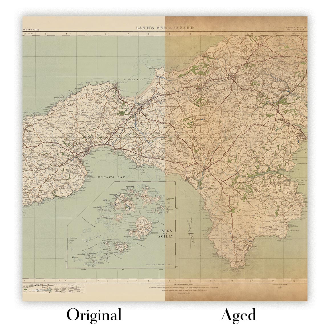
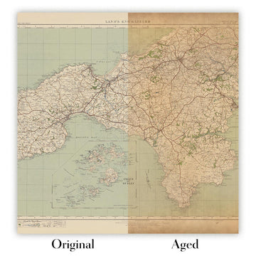
Map ageing
I have been asked hundreds of times over the years by customers if they could buy a map that looks even older.
Well, now you can, by selecting Aged before you add a map to your basket.
All the product photos you see on this page show the map in its Original form. This is what the map looks like today.
If you select Aged, I will age your map by hand, using a special and unique process developed through years of studying old maps, talking to researchers to understand the chemistry of aging paper, and of course... lots of practice!
If you're unsure, stick to the Original colour of the map. If you want something a bit darker and older looking, go for Aged.
If you are not happy with your order for any reason, contact me and I'll get it fixed ASAP, free of charge. Please see my returns and refund policy for more information.
I am very confident you will like your restored map or art print. I have been doing this since 1984. I'm a 5-star Etsy seller. I have sold tens of thousands of maps and art prints and have over 5,000 real 5-star reviews. My work has been featured in interior design magazines, on the BBC, and on the walls of dozens of 5-star hotels.
I use a unique process to restore maps and artwork that is massively time consuming and labour intensive. Hunting down the original maps and illustrations can take months. I use state of the art and eye-wateringly expensive technology to scan and restore them. As a result, I guarantee my maps and art prints are a cut above the rest. I stand by my products and will always make sure you're 100% happy with what you receive.
Almost all of my maps and art prints look amazing at large sizes (200cm, 6.5ft+) and I can frame and deliver them to you as well, via special oversized courier. Contact me to discuss your specific needs.
Or try searching for something!


