


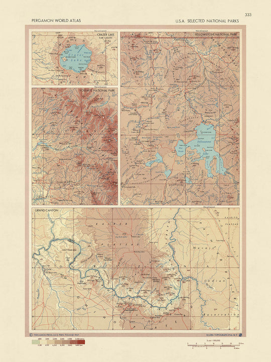


Old Map of USA National Parks, 1967: Yellowstone, Grand Canyon, Yosemite, Crater Lake

-
![]() Handmade in Australia
Handmade in Australia
-
FREE delivery in 3-4 days ⓘ
Free delivery in 3-4 days
Your map should be delivered in 3-4 working days with free delivery, worldwide.
Please use Express Delivery at checkout for Christmas orders. Framed orders may arrive with Express Delivery, but it is not guaranteed.
New for 2025: After you order, you can send a beautiful gift preview by email, if you're worried it won't arrive on time.
We make maps by hand locally in 23 countries, including Australia
![]() . If you're buying a gift for someone in another country, we will make the map locally to them.
. If you're buying a gift for someone in another country, we will make the map locally to them.You will never pay import tax or customs duty.
Check the Christmas delivery guide for order deadlines. Delivery times are starting to slow down, and will continue to slow down towards Christmas.
Express delivery is available at checkout which can reduce the delivery time to 1-2 days.
Please note that personalised maps, and larger framed maps, can take longer to produce and deliver.
If you need your order to arrive by a certain date, contact me and we can discuss your options.
-
FREE gift preview
ⓘ
Digital gift preview
New for 2025: After you complete your order, you can send a beautiful digital preview to the gift recipient. Just provide their email address and we'll do the rest. (Their email address will not be stored or used for any other purpose.)
This is perfect for Christmas gifting, particularly if you're concerned that your order might not arrive in time for Christmas.
-
90 day money back guarantee
ⓘ
90 days to return and refund
Products can be returned within 90 days for a full refund, or exchange for another product.
For personalised and custom made items, we may offer you store credit or a non-expiring gift card, as we cannot resell personalised orders.
If you have any questions, get in touch. For more information, see our full returns & exchanges policy.

My maps are rare, museum-grade, restored old maps sourced from libraries, auction houses and private collections across the globe.
Framing & free personalisation available
1. Select your size
2. Frame & personalise your map
There is limited framing & personalisation capacity available. Order by 10am tomorrow for Christmas delivery.


Gift message & custom finish

If you want to add a gift message, or a finish (jigsaw, aluminium board, etc.) that is not available here, please request it in the "order note" when you check out.
Every order is custom made, so if you need the size adjusted slightly, or printed on an unusual material, just let us know. We've done thousands of custom orders over the years, so there's (almost) nothing we can't manage.
You can also contact us before you order, if you prefer!

- Handmade locally. No import duty or tax
- FREE Delivery by Christmas
- Love it or your money back (90 days)
- Questions? WhatsApp me any time
Own a piece of history
5,000+ 5 star reviews


Introducing "USA - Selected National Parks," a captivating infographic map originally published in 1967 by the Polish Army Topography Service. This remarkable piece serves not just as a navigational tool but as a window into the grandeur of America's natural heritage. Crafted with meticulous attention to detail, it presents an in-depth exploration of four iconic national parks: Yellowstone, Grand Canyon, Crater Lake, and Yosemite. Each park's map is a testament to the unique landscapes and geological features that have fascinated visitors for generations, rendered with precision and clarity at a scale of 1:250,000.
A Fusion of Art and Cartography
The map stands out as a fusion of detailed political and physical mapping, where artistry meets science. The intricate details capture the essence of each park, from the geothermal wonders of Yellowstone to the awe-inspiring depths of the Grand Canyon. The careful delineation of terrains, water bodies, and elevation contours offers a comprehensive view, making it an invaluable resource for enthusiasts of geography and natural history alike.
A Glimpse into the Past
Published during a time when conservation efforts were gaining momentum, "USA - Selected National Parks" reflects a period of growing appreciation for the United States' natural landscapes. Its creation by the Polish Army Topography Service adds a layer of historical significance, representing a cross-cultural tribute to the universal value of nature's marvels. This map is not merely a navigational aid but a historical artifact that captures the spirit of exploration and conservation of the 1960s.
Exploring Four American Treasures
Each section of the map dedicated to Yellowstone, Grand Canyon, Crater Lake, and Yosemite offers a deep dive into the majesty of these landscapes. Yellowstone's map, for instance, highlights its vast network of geothermal features, while the Grand Canyon's portrayal emphasizes its layered rock formations. Crater Lake's deep blue waters are meticulously outlined, showcasing its volcanic origins, whereas Yosemite's map highlights its towering cliffs and waterfalls. These maps serve as a guide to the heart of America's wilderness, inviting exploration and admiration.
A Collector's Dream
"USA - Selected National Parks" is more than a map; it's a collector's piece, a slice of history, and an artistic homage to nature's splendor. Its comprehensive coverage and artistic rendering make it an exceptional item for collectors, historians, and nature lovers alike. Whether framed and displayed or used as a reference for educational purposes, this map is a timeless tribute to some of the most magnificent landscapes on Earth. Perfect for those who cherish the beauty of the natural world and the art of cartography, this map is a luxury item that embodies the spirit of adventure and discovery.
Some of the locations included on the map include:
-
Yellowstone National Park:
- Old Faithful Geyser: The most famous geyser in the park, known for its predictable eruptions.
- Grand Prismatic Spring: The largest hot spring in the United States, notable for its striking colors.
- Yellowstone Grand Canyon: A stunning canyon with two major waterfalls, offering breathtaking views.
- Lamar Valley: Renowned for its wildlife viewing opportunities, including bison, wolves, and elk.
-
Grand Canyon National Park:
- Grand Canyon Village: The starting point for many visitors, with access to the South Rim's spectacular views.
- Havasu Falls: A breathtakingly beautiful waterfall known for its vivid blue-green waters.
- Bright Angel Trail: A popular hiking trail offering incredible views of the canyon's depths.
- North Rim: Offers a quieter, more secluded experience with equally stunning views.
-
Crater Lake National Park:
- Crater Lake: The deepest lake in the United States, known for its deep blue color and water clarity.
- Wizard Island: A cinder cone volcano located within Crater Lake, accessible by boat in the summer.
- Rim Drive: A scenic drive around the caldera, offering various viewpoints of the lake and landscape.
- Phantom Ship: A natural rock formation resembling a ghost ship, visible from various overlooks around the lake.
-
Yosemite National Park:
- Yosemite Valley: The iconic heart of the park, home to famous landmarks like El Capitan and Half Dome.
- Yosemite Falls: One of the tallest waterfalls in North America, visible from many points in the valley.
- Glacier Point: Offers panoramic views of Yosemite Valley, Half Dome, and the High Sierra.
- Mariposa Grove: Home to hundreds of ancient giant sequoias, including the Grizzly Giant and California Tunnel Tree.
Please double check the images to make sure that a specific town or place is shown on this map. You can also get in touch and ask us to check the map for you.
This map looks great at every size, but I always recommend going for a larger size if you have space. That way you can easily make out all of the details.
This map looks amazing at sizes all the way up to 50in (125cm). If you are looking for a larger map, please get in touch.
The model in the listing images is holding the 18x24in (45x60cm) version of this map.
The fifth listing image shows an example of my map personalisation service.
If you’re looking for something slightly different, check out my collection of the best old maps to see if something else catches your eye.
Please contact me to check if a certain location, landmark or feature is shown on this map.
This would make a wonderful birthday, Christmas, Father's Day, work leaving, anniversary or housewarming gift for someone from the areas covered by this map.
This map is available as a giclée print on acid free archival matte paper, or you can buy it framed. The frame is a nice, simple black frame that suits most aesthetics. Please get in touch if you'd like a different frame colour or material. My frames are glazed with super-clear museum-grade acrylic (perspex/acrylite), which is significantly less reflective than glass, safer, and will always arrive in perfect condition.
This map is also available as a float framed canvas, sometimes known as a shadow gap framed canvas or canvas floater. The map is printed on artist's cotton canvas and then stretched over a handmade box frame. We then "float" the canvas inside a wooden frame, which is available in a range of colours (black, dark brown, oak, antique gold and white). This is a wonderful way to present a map without glazing in front. See some examples of float framed canvas maps and explore the differences between my different finishes.
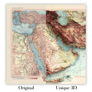
For something truly unique, this map is also available in "Unique 3D", our trademarked process that dramatically transforms the map so that it has a wonderful sense of depth. We combine the original map with detailed topography and elevation data, so that mountains and the terrain really "pop". For more info and examples of 3D maps, check my Unique 3D page.
For most orders, delivery time is about 3 working days. Personalised and customised products take longer, as I have to do the personalisation and send it to you for approval, which usually takes 1 or 2 days.
Please note that very large framed orders usually take longer to make and deliver.
If you need your order to arrive by a certain date, please contact me before you order so that we can find the best way of making sure you get your order in time.
I print and frame maps and artwork in 23 countries around the world. This means your order will be made locally, which cuts down on delivery time and ensures that it won't be damaged during delivery. You'll never pay customs or import duty, and we'll put less CO2 into the air.
All of my maps and art prints are well packaged and sent in a rugged tube if unframed, or surrounded by foam if framed.
I try to send out all orders within 1 or 2 days of receiving your order, though some products (like face masks, mugs and tote bags) can take longer to make.
If you select Express Delivery at checkout your order we will prioritise your order and send it out by 1-day courier (Fedex, DHL, UPS, Parcelforce).
Next Day delivery is also available in some countries (US, UK, Singapore, UAE) but please try to order early in the day so that we can get it sent out on time.
My standard frame is a gallery style black ash hardwood frame. It is simple and quite modern looking. My standard frame is around 20mm (0.8in) wide.
I use super-clear acrylic (perspex/acrylite) for the frame glass. It's lighter and safer than glass - and it looks better, as the reflectivity is lower.
Six standard frame colours are available for free (black, dark brown, dark grey, oak, white and antique gold). Custom framing and mounting/matting is available if you're looking for something else.
Most maps, art and illustrations are also available as a framed canvas. We use matte (not shiny) cotton canvas, stretch it over a sustainably sourced box wood frame, and then 'float' the piece within a wood frame. The end result is quite beautiful, and there's no glazing to get in the way.
All frames are provided "ready to hang", with either a string or brackets on the back. Very large frames will have heavy duty hanging plates and/or a mounting baton. If you have any questions, please get in touch.
See some examples of my framed maps and framed canvas maps.
Alternatively, I can also supply old maps and artwork on canvas, foam board, cotton rag and other materials.
If you want to frame your map or artwork yourself, please read my size guide first.
My maps are extremely high quality reproductions of original maps.
I source original, rare maps from libraries, auction houses and private collections around the world, restore them at my London workshop, and then use specialist giclée inks and printers to create beautiful maps that look even better than the original.
My maps are printed on acid-free archival matte (not glossy) paper that feels very high quality and almost like card. In technical terms the paper weight/thickness is 10mil/200gsm. It's perfect for framing.
I print with Epson ultrachrome giclée UV fade resistant pigment inks - some of the best inks you can find.
I can also make maps on canvas, cotton rag and other exotic materials.
Learn more about The Unique Maps Co.
Map personalisation
If you're looking for the perfect anniversary or housewarming gift, I can personalise your map to make it truly unique. For example, I can add a short message, or highlight an important location, or add your family's coat of arms.
The options are almost infinite. Please see my map personalisation page for some wonderful examples of what's possible.
To order a personalised map, select "personalise your map" before adding it to your basket.
Get in touch if you're looking for more complex customisations and personalisations.
Map ageing
I have been asked hundreds of times over the years by customers if they could buy a map that looks even older.
Well, now you can, by selecting Aged before you add a map to your basket.
All the product photos you see on this page show the map in its Original form. This is what the map looks like today.
If you select Aged, I will age your map by hand, using a special and unique process developed through years of studying old maps, talking to researchers to understand the chemistry of aging paper, and of course... lots of practice!
If you're unsure, stick to the Original colour of the map. If you want something a bit darker and older looking, go for Aged.
If you are not happy with your order for any reason, contact me and I'll get it fixed ASAP, free of charge. Please see my returns and refund policy for more information.
I am very confident you will like your restored map or art print. I have been doing this since 1984. I'm a 5-star Etsy seller. I have sold tens of thousands of maps and art prints and have over 5,000 real 5-star reviews. My work has been featured in interior design magazines, on the BBC, and on the walls of dozens of 5-star hotels.
I use a unique process to restore maps and artwork that is massively time consuming and labour intensive. Hunting down the original maps and illustrations can take months. I use state of the art and eye-wateringly expensive technology to scan and restore them. As a result, I guarantee my maps and art prints are a cut above the rest. I stand by my products and will always make sure you're 100% happy with what you receive.
Almost all of my maps and art prints look amazing at large sizes (200cm, 6.5ft+) and I can frame and deliver them to you as well, via special oversized courier. Contact me to discuss your specific needs.
Or try searching for something!


