


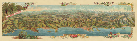


Old Birdseye Map of Côte d’Azur by Legresle, 1925: Nice, Cannes, Monaco, Antibes, Toulon
20% off 2 — 33% off 3
Add any two eligible items to your bag to receive 20% off. Add a third and it will be complimentary (equivalent to 33% off when purchasing three).
No code needed — the offer applies automatically at checkout.
Valid on all standard maps and fine art prints. You can mix and match any designs.
If you’d like to ship items to multiple addresses, please contact us before placing your order.
Custom and bespoke commissions are excluded.
Contact us if you have any questions
-
![]() Handmade in Australia
Handmade in Australia

-
FREE worldwide delivery in 2-3 days ⓘ
Free delivery in 2-3 days
Your map should be delivered in 2-3 working days with free delivery, worldwide.
We make maps by hand locally in 23 countries, including Australia
![]() . If you're buying a gift for someone in another country, we will make the map locally to them.
. If you're buying a gift for someone in another country, we will make the map locally to them.You will never pay import tax or customs duty.
Express delivery is available at checkout which can reduce the delivery time to 1-2 days.
Please note that personalised maps, and larger framed maps, can take longer to produce and deliver.
If you need your order to arrive by a certain date, contact me and we can discuss your options.
-
Complimentary gifting & design advice
ⓘ
Complimentary gifting & design advice
Available almost 24/7 on WhatsApp and email — we usually reply within minutes. We can help you:
- Choose a perfectly personalised gift
- Send a digital gift preview to the recipient
- Pick the ideal size for your wall
- Select the right finish and frame
Quick, friendly advice so you can order with confidence.
For last minute gifts, consider buying a digital gift card. We have over 5,000 maps and art prints to choose from.
-
90-day returns & 5-year guarantee
ⓘ
90-day returns & 5-year guarantee
Products can be returned within 90 days for a full refund, or exchange for another product.
We are also proud to offer a 5-year quality guarantee on our maps and art, covering defects in materials or workmanship under normal use.
For personalised and custom made items, we may offer you store credit or a non-expiring gift card, as we cannot resell personalised orders.
If you have any questions, get in touch. For more information, see our full returns & exchanges policy.

This is a museum-grade archival print from the original 1925 map — restored in our workshop and made to order on 220gsm archival matte paper or 400gsm artist's cotton canvas with pigment inks.
Professional framing & free personalisation available.
1. Choose a size
2. Frame & personalise your map
Make your map unique with framing, hand-drawn customisation, vintage ageing, pop art text, unique 3D styling and more.


Gift message & custom finish

If you want to add a gift message, or a finish (jigsaw, aluminium board, etc.) that is not available here, please request it in the "order note" when you check out.
Every order is custom made, so if you need the size adjusted slightly, or printed on an unusual material, just let us know. We've done thousands of custom orders over the years, so there's (almost) nothing we can't manage.
You can also contact us before you order, if you prefer!

- Handmade locally. No import duty or tax
- FREE worldwide delivery
- 90-day returns & 5-year product guarantee
- Questions? WhatsApp me any time
Own a piece of history
7,000+ 5 star reviews


Step into the sun-drenched elegance of the French Riviera with "La Côte d’Azur," a captivating pictorial map crafted by the esteemed C. Legresle in 1925. This enchanting work, whose title evokes the legendary coastline it celebrates, offers a sweeping bird’s-eye view of one of Europe’s most glamorous regions at the height of its interwar allure. Legresle’s artistry transports the viewer across azure waters and rolling hills, inviting you to trace the Mediterranean’s sinuous edge as it curves past storied harbors and lush, palm-fringed promenades. Each brushstroke radiates the spirit of a golden era, when the Côte d’Azur emerged as a playground for artists, aristocrats, and travelers seeking both luxury and inspiration.
C. Legresle, renowned for his evocative and decorative cartography, brings a singular vision to this map, blending precision with an almost cinematic flair. His illustrative style transforms geography into art, with vibrant colors and lively vignettes that capture the Riviera’s unique topography. Rather than simply marking political boundaries, Legresle focuses on the region’s natural grandeur—its dramatic mountains, gentle hills, and sparkling bays. The map’s orientation and perspective enhance the dramatic interplay between land and sea, drawing the eye from the bustling coastline to the tranquil hinterlands beyond.
The map’s design is a testament to the period’s fascination with travel, leisure, and the beauty of the natural world. Ornate cartouches and decorative borders frame the scene, while playful embellishments—sailing boats gliding across the Mediterranean, elegant villas nestled among cypresses, and grand hotels perched above the shore—convey the Riviera’s reputation for opulence and relaxation. Roads and railways thread through the landscape, hinting at the burgeoning accessibility that transformed this once-remote coastline into a cosmopolitan destination for the world’s elite.
Within this exquisite panorama, a constellation of celebrated towns and cities beckons. From the bustling boulevards of Nice and the cinematic glamour of Cannes to the historic charm of Antibes and the pastel-hued facades of Menton, each settlement is rendered with affectionate detail. Monaco’s principality glimmers along the border, while Saint-Tropez, Grasse, and Hyères evoke the region’s rich tapestry of culture, history, and natural splendor. The map’s careful depiction of harbors, marinas, and verdant gardens underscores the Côte d’Azur’s enduring appeal as a haven for artists, writers, and sun-seekers alike.
"La Côte d’Azur" is more than a map—it is a visual celebration of a legendary landscape at a pivotal moment in its history. Created during a period of social and artistic transformation, this map captures the Riviera’s transformation from provincial coastline to international icon. It stands as both a historical document and a work of art, inviting collectors and connoisseurs to experience the timeless allure of southern France through the eyes of one of its most gifted cartographers.
Cities and towns on this map
- Nice
- Toulon
- Cannes
- Antibes
- Menton
- Grasse
- Saint-Raphaël
- Fréjus
- Hyères
- Beaulieu-sur-Mer
- Villefranche-sur-Mer
- Saint-Tropez
- Juan-les-Pins
- Monte Carlo & Monaco (Principality of Monaco, adjacent to France)
Notable Features & Landmarks
- The Mediterranean Sea is prominently depicted along the southern edge of the map.
- Mountain ranges and hills are illustrated in the northern part of the region.
- The coastline is detailed with bays, capes, and beaches.
- Several harbors and marinas are illustrated along the coast.
- The map features artistic renderings of palm trees and lush vegetation, emphasizing the region’s mild climate.
- Roads and railways are drawn, connecting the coastal settlements.
- Decorative elements such as boats and ships are shown in the sea.
- The map includes illustrations of villas, châteaux, and grand hotels, highlighting the region’s luxury tourism.
- Artistic embellishments, such as ornate title cartouches and decorative borders, are present.
- The map is oriented with a perspective that enhances the dramatic landscape of the Riviera.
Historical and design context
- Name of the map: La Côte d’Azur
- Date of creation: 1925 (estimated by experts)
- Mapmaker: C. Legresle, known for decorative and illustrative maps of French regions in the early 20th century.
- Map type: Bird’s eye view pictorial map, also known as a County or State Birds Eye View map.
- The map highlights the scenic beauty, landscapes, and coastal features of the Côte d’Azur, emphasizing tourism and the region’s allure.
- Design/style: Uses a pictorial, illustrative style with vibrant colors and artistic renderings of natural and human-made features.
- Historical significance: Created during the interwar period, when the Côte d’Azur was becoming a major destination for tourism and leisure among Europeans.
- The map is not intended for navigation but for visual appreciation and promotion of the region’s attractions.
Please double check the images to make sure that a specific town or place is shown on this map. You can also get in touch and ask us to check the map for you.
This map looks great at every size, but I always recommend going for a larger size if you have space. That way you can easily make out all of the details.
This map looks amazing at sizes all the way up to 100in (250cm). If you are looking for a larger map, please get in touch.
Please note: the labels on this map are hard to read if you order a map that is 20in (50cm) or smaller. The map is still very attractive, but if you would like to read the map easily, please buy a larger size.
This map is wider than most maps, which would make it a perfect statement piece above a mantelpiece, sofa or desk.
The fifth listing image shows an example of my map personalisation service.
If you’re looking for something slightly different, check out my collection of the best old maps to see if something else catches your eye.
Please contact me to check if a certain location, landmark or feature is shown on this map.
This would make a wonderful birthday, Christmas, Father's Day, work leaving, anniversary or housewarming gift for someone from the areas covered by this map.
This map is available as a giclée print on acid free archival matte paper, or you can buy it framed. The frame is a nice, simple black frame that suits most aesthetics. Please get in touch if you'd like a different frame colour or material. My frames are glazed with super-clear museum-grade acrylic (perspex/acrylite), which is significantly less reflective than glass, safer, and will always arrive in perfect condition.
This map is also available as a float framed canvas, sometimes known as a shadow gap framed canvas or canvas floater. The map is printed on artist's cotton canvas and then stretched over a handmade box frame. We then "float" the canvas inside a wooden frame, which is available in a range of colours (black, dark brown, oak, antique gold and white). This is a wonderful way to present a map without glazing in front. See some examples of float framed canvas maps and explore the differences between my different finishes.
For something truly unique, this map is also available in "Unique 3D", our trademarked process that dramatically transforms the map so that it has a wonderful sense of depth. We combine the original map with detailed topography and elevation data, so that mountains and the terrain really "pop". For more info and examples of 3D maps, check my Unique 3D page.
For most orders, delivery time is about 3 working days. Personalised and customised products take longer, as I have to do the personalisation and send it to you for approval, which usually takes 1 or 2 days.
Please note that very large framed orders usually take longer to make and deliver.
If you need your order to arrive by a certain date, please contact me before you order so that we can find the best way of making sure you get your order in time.
I print and frame maps and artwork in 23 countries around the world. This means your order will be made locally, which cuts down on delivery time and ensures that it won't be damaged during delivery. You'll never pay customs or import duty, and we'll put less CO2 into the air.
All of my maps and art prints are well packaged and sent in a rugged tube if unframed, or surrounded by foam if framed.
I try to send out all orders within 1 or 2 days of receiving your order, though some products (like face masks, mugs and tote bags) can take longer to make.
If you select Express Delivery at checkout your order we will prioritise your order and send it out by 1-day courier (Fedex, DHL, UPS, Parcelforce).
Next Day delivery is also available in some countries (US, UK, Singapore, UAE) but please try to order early in the day so that we can get it sent out on time.
My standard frame is a gallery style black ash hardwood frame. It is simple and quite modern looking. My standard frame is around 20mm (0.8in) wide.
I use super-clear acrylic (perspex/acrylite) for the frame glass. It's lighter and safer than glass - and it looks better, as the reflectivity is lower.
Six standard frame colours are available for free (black, dark brown, dark grey, oak, white and antique gold). Custom framing and mounting/matting is available if you're looking for something else.
Most maps, art and illustrations are also available as a framed canvas. We use matte (not shiny) cotton canvas, stretch it over a sustainably sourced box wood frame, and then 'float' the piece within a wood frame. The end result is quite beautiful, and there's no glazing to get in the way.
All frames are provided "ready to hang", with either a string or brackets on the back. Very large frames will have heavy duty hanging plates and/or a mounting baton. If you have any questions, please get in touch.
See some examples of my framed maps and framed canvas maps.
Alternatively, I can also supply old maps and artwork on canvas, foam board, cotton rag and other materials.
If you want to frame your map or artwork yourself, please read my size guide first.
My maps are extremely high quality reproductions of original maps.
I source original, rare maps from libraries, auction houses and private collections around the world, restore them at my London workshop, and then use specialist giclée inks and printers to create beautiful maps that look even better than the original.
My maps are printed on acid-free archival matte (not glossy) paper that feels very high quality and almost like card. In technical terms the paper weight/thickness is 10mil/200gsm. It's perfect for framing.
I print with Epson ultrachrome giclée UV fade resistant pigment inks - some of the best inks you can find.
I can also make maps on canvas, cotton rag and other exotic materials.
Learn more about The Unique Maps Co.
Map personalisation
If you're looking for the perfect anniversary or housewarming gift, I can personalise your map to make it truly unique. For example, I can add a short message, or highlight an important location, or add your family's coat of arms.
The options are almost infinite. Please see my map personalisation page for some wonderful examples of what's possible.
To order a personalised map, select "personalise your map" before adding it to your basket.
Get in touch if you're looking for more complex customisations and personalisations.
Map ageing
I have been asked hundreds of times over the years by customers if they could buy a map that looks even older.
Well, now you can, by selecting Aged before you add a map to your basket.
All the product photos you see on this page show the map in its Original form. This is what the map looks like today.
If you select Aged, I will age your map by hand, using a special and unique process developed through years of studying old maps, talking to researchers to understand the chemistry of aging paper, and of course... lots of practice!
If you're unsure, stick to the Original colour of the map. If you want something a bit darker and older looking, go for Aged.
If you are not happy with your order for any reason, contact me and I'll get it fixed ASAP, free of charge. Please see my returns and refund policy for more information.
I am very confident you will like your restored map or art print. I have been doing this since 1984. I'm a 5-star Etsy seller. I have sold tens of thousands of maps and art prints and have over 5,000 real 5-star reviews. My work has been featured in interior design magazines, on the BBC, and on the walls of dozens of 5-star hotels.
I use a unique process to restore maps and artwork that is massively time consuming and labour intensive. Hunting down the original maps and illustrations can take months. I use state of the art and eye-wateringly expensive technology to scan and restore them. As a result, I guarantee my maps and art prints are a cut above the rest. I stand by my products and will always make sure you're 100% happy with what you receive.
Almost all of my maps and art prints look amazing at large sizes (200cm, 6.5ft+) and I can frame and deliver them to you as well, via special oversized courier. Contact me to discuss your specific needs.
Or try searching for something!


