


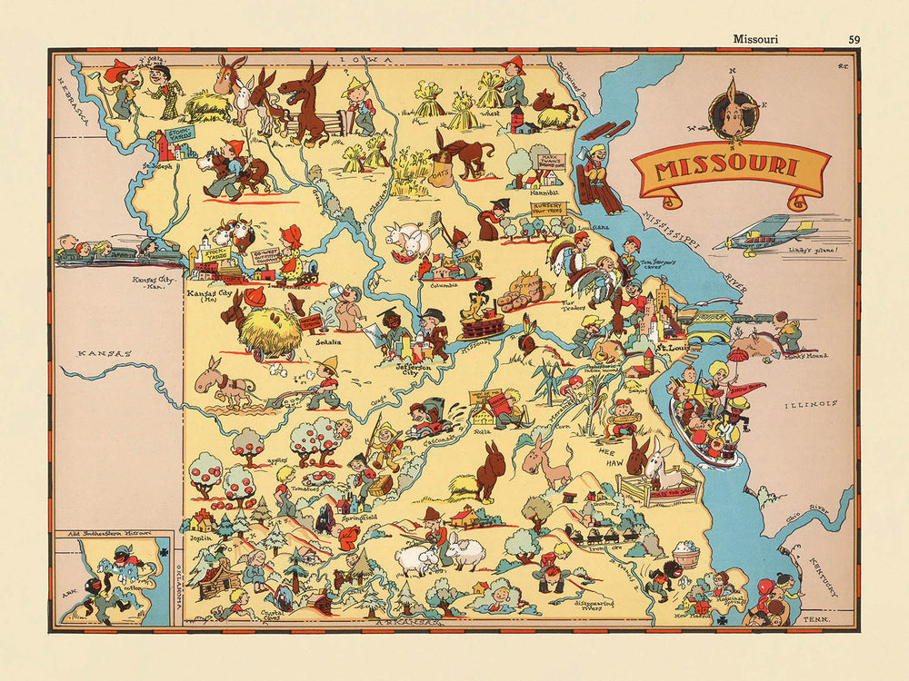


Pictorial Map of Missouri by Ruth Taylor White, 1935: St. Louis, Kansas City, Ozarks, Mississippi & Missouri Rivers, Jefferson City
Buy 2, Get 1 Free
If you add 2 items to your bag, you can add a third product for free. The discount is automatic - no code required.
This is equivalent to 33% off, which will be the largest discount available on my shop this year.
This works for all maps and artwork. You can order 3 of the same thing, or 3 different things.
My custom maps are excluded, as they're too time consuming to make and we'd prefer to take our time rather than rush through a lot of orders.
Please take advantage of the deal and buy lots of beautiful maps and art for your walls.
Contact me if you have any questions.

-
![]() Handmade in Australia
Handmade in Australia
-
FREE worldwide delivery in 2-3 days ⓘ
Free delivery in 2-3 days
Your map should be delivered in 2-3 working days with free delivery, worldwide.
Deliveries over the Christmas and New Year period may be slightly delayed, as couriers and postal services catch up with a huge backlog of packages.
We make maps by hand locally in 23 countries, including Australia
![]() . If you're buying a gift for someone in another country, we will make the map locally to them.
. If you're buying a gift for someone in another country, we will make the map locally to them.You will never pay import tax or customs duty.
Express delivery is available at checkout which can reduce the delivery time to 1-2 days.
Please note that personalised maps, and larger framed maps, can take longer to produce and deliver.
If you need your order to arrive by a certain date, contact me and we can discuss your options.
-
FREE gift preview
ⓘ
Digital gift preview
After you complete your order, you can send a beautiful digital preview to the gift recipient. Just provide their email address and we'll do the rest. (Their email address will not be stored or used for any other purpose.)
This is perfect if you're concerned that your order might not arrive in time.
You can also buy a real non-expiring gift card, and email it directly to the recipient, so they can buy their own map or artwork.
-
90 day money back guarantee
ⓘ
90 days to return and refund
Products can be returned within 90 days for a full refund, or exchange for another product.
For personalised and custom made items, we may offer you store credit or a non-expiring gift card, as we cannot resell personalised orders.
If you have any questions, get in touch. For more information, see our full returns & exchanges policy.

My maps are rare, museum-grade, restored old maps sourced from libraries, auction houses and private collections across the globe.
Framing & free personalisation available
1. Select your size
Click here to order a custom size.
2. Frame & personalise your map
Make your map unique with framing, hand-drawn customisation, vintage ageing, pop art text, unique 3D styling and more.


Gift message & custom finish

If you want to add a gift message, or a finish (jigsaw, aluminium board, etc.) that is not available here, please request it in the "order note" when you check out.
Every order is custom made, so if you need the size adjusted slightly, or printed on an unusual material, just let us know. We've done thousands of custom orders over the years, so there's (almost) nothing we can't manage.
You can also contact us before you order, if you prefer!

- Handmade locally. No import duty or tax
- FREE worldwide delivery
- Love it or your money back (90 days)
- Questions? WhatsApp me any time
Own a piece of history
5,000+ 5 star reviews


Step into the vibrant world of 1930s Missouri with the captivating pictorial map, “Missouri,” originally crafted by Ruth Taylor White in 1935. This enchanting cartographic work offers a lively tableau of the Show-Me State, blending whimsical artistry with rich historical narrative. The map’s original title, simply “Missouri,” reflects its focus on capturing the essence of the state at a particular moment in time, inviting viewers to explore a tapestry of culture, industry, and natural beauty. Each corner of the map bursts with color and character, transporting you to a bygone era when the very landscape of Missouri was interpreted through the playful and imaginative lens of one of America’s most celebrated pictorial mapmakers.
Ruth Taylor White, the creative force behind this map, was renowned for her distinctive approach to cartography. Her maps were more than navigational aids—they were windows into the soul of a place, alive with humor, local color, and affectionate caricature. Working alongside her husband, Frank J. Taylor, who often served as editor and compiler, White produced a series of state maps that became beloved for their ability to both educate and entertain. Her Missouri map is a masterclass in this tradition, filled with delightful vignettes that capture the state’s agricultural heart, industrial vigor, and cultural vibrancy, all rendered in her unmistakable, cartoon-like style.
The design of this map is nothing short of a visual feast. Every inch is adorned with charming illustrations that convey the state’s defining features and local lore. The mighty Mississippi and Missouri Rivers snake across the landscape, their importance underscored by bustling steamboats and lively river scenes. The Ozark Mountains rise in the south, their wooded slopes dotted with timber activities and outdoor pursuits. Agricultural abundance is celebrated through depictions of cornfields, livestock, and grape harvests, while the presence of mules and pioneers hints at Missouri’s storied past and enduring traditions. Each illustration serves as both decoration and documentation, making the map as informative as it is delightful.
Beyond its artistic appeal, this map offers a fascinating glimpse into the social and economic narratives that shaped Missouri in the early twentieth century. The state’s diverse industries—mining, farming, winemaking—are all vividly represented, alongside scenes of music, dance, and everyday life. Native American motifs and historical figures are woven into the fabric of the map, providing subtle nods to the deeper currents of Missouri’s heritage. The map’s decorative title cartouche and stylized borders further enhance its period charm, reflecting the optimism and creative spirit of the 1930s.
The cities and towns depicted on the map read like a roll call of Missouri’s most storied communities, from the bustling metropolises of Kansas City and St. Louis to the historic river town of Hannibal and the state capital, Jefferson City. Each settlement is carefully placed, offering a sense of the state’s geography and the interconnectedness of its people. This map is not merely a record of place names and boundaries—it is a celebration of Missouri’s unique identity, a testament to the artistry of Ruth Taylor White, and a piece of Americana that continues to enchant collectors and history enthusiasts alike.
Cities and towns on this map
- Kansas City
- St. Louis
- Springfield
- Columbia
- St. Joseph
- Joplin
- Jefferson City
- Hannibal
- Sedalia
- Carthage
- Cape Girardeau
- Moberly
- Poplar Bluff
- Nevada
- Maryville
- Rolla
- Sikeston
- Fulton
- Mexico
- Kirksville
Notable Features & Landmarks
- The Mississippi River is prominently illustrated along Missouri’s eastern border.
- The Missouri River is shown winding across the state.
- Agricultural scenes, such as cornfields and livestock (cattle, pigs, chickens), are depicted in various regions.
- A depiction of mining activity, likely referencing Missouri’s lead mining industry.
- Illustrations of steamboats on the Mississippi River.
- Images of people engaged in activities such as fishing and hunting.
- Representation of the Ozark Mountains in the southern part of the state.
- Artistic depictions of forests and timber activities.
- Illustration of musical instruments and dancing, referencing Missouri’s cultural heritage.
- Scenes of grape harvesting and wine production, likely referencing the state’s wine industry.
- Images of Native American figures and motifs.
- Depictions of historical figures or pioneers.
- A large ear of corn, symbolizing the importance of agriculture.
- Illustrations of mules, a symbol often associated with Missouri.
- The state border is clearly marked and stylized.
- The map features a decorative title cartouche with the name "Missouri."
Historical and design context
- Name of the map: Missouri (original title as shown on the map)
- Date created: 1935
- Mapmaker: Ruth Taylor White
- Publisher: Frank J. Taylor (often credited as the editor or compiler for this atlas series)
- Type of map: County or State Thematic and Pictorial map
- Artistic style: The map features vibrant, colorful, and cartoon-like illustrations, characteristic of pictorial maps from the 1930s.
- Themes depicted: The map uses playful and exaggerated illustrations to represent stereotypical scenes, industries, and cultural elements associated with Missouri in the 1930s.
- Purpose: Designed to entertain and educate, offering a whimsical yet informative look at the state’s culture, economy, and history.
- Historical context: Reflects the social and cultural narratives of Missouri during the early 20th century, including the state’s agricultural, industrial, and social life.
- Significance: Part of a larger trend in the 1930s of creating pictorial atlases that blended art, humor, and geography, making maps more accessible and engaging to the public.
- Design context: Decorative elements are used not just for visual appeal but to convey information about Missouri’s people, industries, and way of life during the period.
- Notable for: Its blend of art and history, providing insight into how Missouri was perceived and represented in popular culture at the time.
Please double check the images to make sure that a specific town or place is shown on this map. You can also get in touch and ask us to check the map for you.
This map looks great at every size, but I always recommend going for a larger size if you have space. That way you can easily make out all of the details.
This map looks amazing at sizes all the way up to 50in (125cm). If you are looking for a larger map, please get in touch.
The model in the listing images is holding the 18x24in (45x60cm) version of this map.
The fifth listing image shows an example of my map personalisation service.
If you’re looking for something slightly different, check out my collection of the best old maps to see if something else catches your eye.
Please contact me to check if a certain location, landmark or feature is shown on this map.
This would make a wonderful birthday, Christmas, Father's Day, work leaving, anniversary or housewarming gift for someone from the areas covered by this map.
This map is available as a giclée print on acid free archival matte paper, or you can buy it framed. The frame is a nice, simple black frame that suits most aesthetics. Please get in touch if you'd like a different frame colour or material. My frames are glazed with super-clear museum-grade acrylic (perspex/acrylite), which is significantly less reflective than glass, safer, and will always arrive in perfect condition.
This map is also available as a float framed canvas, sometimes known as a shadow gap framed canvas or canvas floater. The map is printed on artist's cotton canvas and then stretched over a handmade box frame. We then "float" the canvas inside a wooden frame, which is available in a range of colours (black, dark brown, oak, antique gold and white). This is a wonderful way to present a map without glazing in front. See some examples of float framed canvas maps and explore the differences between my different finishes.
For something truly unique, this map is also available in "Unique 3D", our trademarked process that dramatically transforms the map so that it has a wonderful sense of depth. We combine the original map with detailed topography and elevation data, so that mountains and the terrain really "pop". For more info and examples of 3D maps, check my Unique 3D page.
For most orders, delivery time is about 3 working days. Personalised and customised products take longer, as I have to do the personalisation and send it to you for approval, which usually takes 1 or 2 days.
Please note that very large framed orders usually take longer to make and deliver.
If you need your order to arrive by a certain date, please contact me before you order so that we can find the best way of making sure you get your order in time.
I print and frame maps and artwork in 23 countries around the world. This means your order will be made locally, which cuts down on delivery time and ensures that it won't be damaged during delivery. You'll never pay customs or import duty, and we'll put less CO2 into the air.
All of my maps and art prints are well packaged and sent in a rugged tube if unframed, or surrounded by foam if framed.
I try to send out all orders within 1 or 2 days of receiving your order, though some products (like face masks, mugs and tote bags) can take longer to make.
If you select Express Delivery at checkout your order we will prioritise your order and send it out by 1-day courier (Fedex, DHL, UPS, Parcelforce).
Next Day delivery is also available in some countries (US, UK, Singapore, UAE) but please try to order early in the day so that we can get it sent out on time.
My standard frame is a gallery style black ash hardwood frame. It is simple and quite modern looking. My standard frame is around 20mm (0.8in) wide.
I use super-clear acrylic (perspex/acrylite) for the frame glass. It's lighter and safer than glass - and it looks better, as the reflectivity is lower.
Six standard frame colours are available for free (black, dark brown, dark grey, oak, white and antique gold). Custom framing and mounting/matting is available if you're looking for something else.
Most maps, art and illustrations are also available as a framed canvas. We use matte (not shiny) cotton canvas, stretch it over a sustainably sourced box wood frame, and then 'float' the piece within a wood frame. The end result is quite beautiful, and there's no glazing to get in the way.
All frames are provided "ready to hang", with either a string or brackets on the back. Very large frames will have heavy duty hanging plates and/or a mounting baton. If you have any questions, please get in touch.
See some examples of my framed maps and framed canvas maps.
Alternatively, I can also supply old maps and artwork on canvas, foam board, cotton rag and other materials.
If you want to frame your map or artwork yourself, please read my size guide first.
My maps are extremely high quality reproductions of original maps.
I source original, rare maps from libraries, auction houses and private collections around the world, restore them at my London workshop, and then use specialist giclée inks and printers to create beautiful maps that look even better than the original.
My maps are printed on acid-free archival matte (not glossy) paper that feels very high quality and almost like card. In technical terms the paper weight/thickness is 10mil/200gsm. It's perfect for framing.
I print with Epson ultrachrome giclée UV fade resistant pigment inks - some of the best inks you can find.
I can also make maps on canvas, cotton rag and other exotic materials.
Learn more about The Unique Maps Co.
Map personalisation
If you're looking for the perfect anniversary or housewarming gift, I can personalise your map to make it truly unique. For example, I can add a short message, or highlight an important location, or add your family's coat of arms.
The options are almost infinite. Please see my map personalisation page for some wonderful examples of what's possible.
To order a personalised map, select "personalise your map" before adding it to your basket.
Get in touch if you're looking for more complex customisations and personalisations.
Map ageing
I have been asked hundreds of times over the years by customers if they could buy a map that looks even older.
Well, now you can, by selecting Aged before you add a map to your basket.
All the product photos you see on this page show the map in its Original form. This is what the map looks like today.
If you select Aged, I will age your map by hand, using a special and unique process developed through years of studying old maps, talking to researchers to understand the chemistry of aging paper, and of course... lots of practice!
If you're unsure, stick to the Original colour of the map. If you want something a bit darker and older looking, go for Aged.
If you are not happy with your order for any reason, contact me and I'll get it fixed ASAP, free of charge. Please see my returns and refund policy for more information.
I am very confident you will like your restored map or art print. I have been doing this since 1984. I'm a 5-star Etsy seller. I have sold tens of thousands of maps and art prints and have over 5,000 real 5-star reviews. My work has been featured in interior design magazines, on the BBC, and on the walls of dozens of 5-star hotels.
I use a unique process to restore maps and artwork that is massively time consuming and labour intensive. Hunting down the original maps and illustrations can take months. I use state of the art and eye-wateringly expensive technology to scan and restore them. As a result, I guarantee my maps and art prints are a cut above the rest. I stand by my products and will always make sure you're 100% happy with what you receive.
Almost all of my maps and art prints look amazing at large sizes (200cm, 6.5ft+) and I can frame and deliver them to you as well, via special oversized courier. Contact me to discuss your specific needs.
Or try searching for something!


