


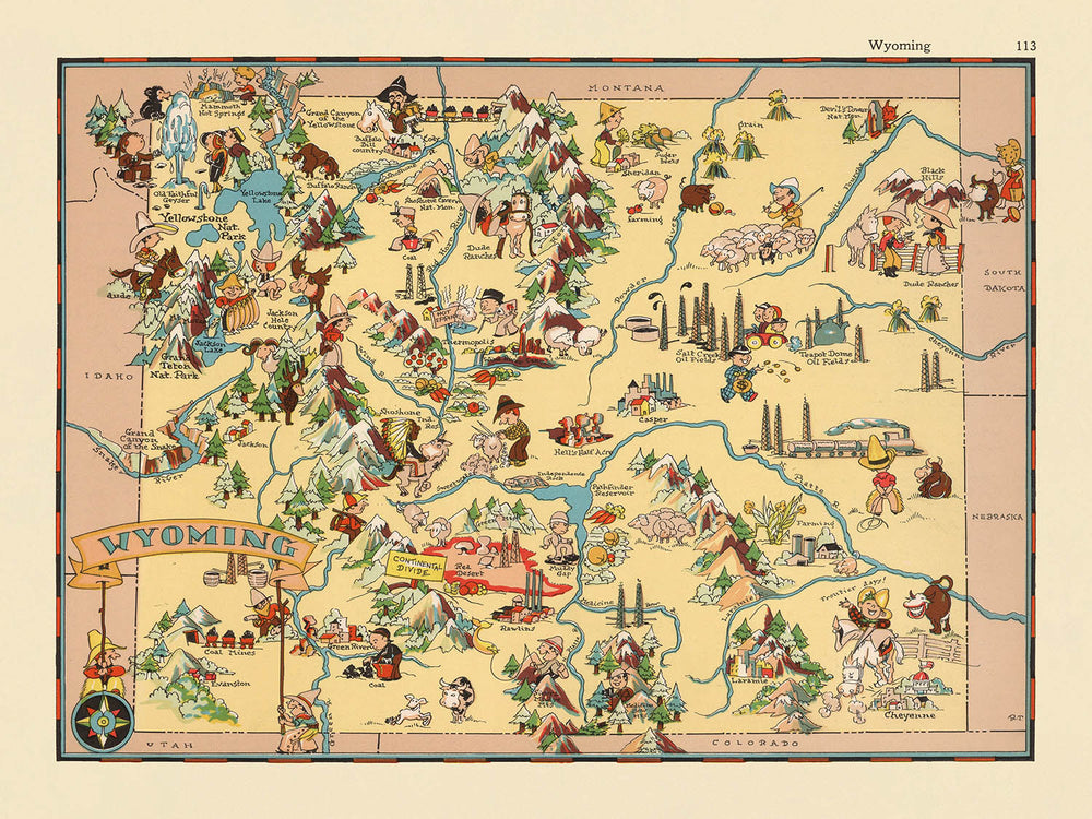


Pictorial Map of Wyoming by Ruth Taylor White, 1935: Yellowstone, Grand Teton, Continental Divide, Wind River Range, Bighorn Mountains
Buy 2, Get 1 Free
If you add 2 items to your bag, you can add a third product for free. The discount is automatic - no code required.
This is equivalent to 33% off, which will be the largest discount available on my shop this year.
This works for all maps and artwork. You can order 3 of the same thing, or 3 different things.
My custom maps are excluded, as they're too time consuming to make and we'd prefer to take our time rather than rush through a lot of orders.
Please take advantage of the deal and buy lots of beautiful maps and art for your walls.
Contact me if you have any questions.

-
![]() Handmade in Australia
Handmade in Australia
-
FREE worldwide delivery in 2-3 days ⓘ
Free delivery in 2-3 days
Your map should be delivered in 2-3 working days with free delivery, worldwide.
Deliveries over the Christmas and New Year period may be slightly delayed, as couriers and postal services catch up with a huge backlog of packages.
We make maps by hand locally in 23 countries, including Australia
![]() . If you're buying a gift for someone in another country, we will make the map locally to them.
. If you're buying a gift for someone in another country, we will make the map locally to them.You will never pay import tax or customs duty.
Express delivery is available at checkout which can reduce the delivery time to 1-2 days.
Please note that personalised maps, and larger framed maps, can take longer to produce and deliver.
If you need your order to arrive by a certain date, contact me and we can discuss your options.
-
FREE gift preview
ⓘ
Digital gift preview
After you complete your order, you can send a beautiful digital preview to the gift recipient. Just provide their email address and we'll do the rest. (Their email address will not be stored or used for any other purpose.)
This is perfect if you're concerned that your order might not arrive in time.
You can also buy a real non-expiring gift card, and email it directly to the recipient, so they can buy their own map or artwork.
-
90 day money back guarantee
ⓘ
90 days to return and refund
Products can be returned within 90 days for a full refund, or exchange for another product.
For personalised and custom made items, we may offer you store credit or a non-expiring gift card, as we cannot resell personalised orders.
If you have any questions, get in touch. For more information, see our full returns & exchanges policy.

My maps are rare, museum-grade, restored old maps sourced from libraries, auction houses and private collections across the globe.
Framing & free personalisation available
1. Select your size
Click here to order a custom size.
2. Frame & personalise your map
Make your map unique with framing, hand-drawn customisation, vintage ageing, pop art text, unique 3D styling and more.


Gift message & custom finish

If you want to add a gift message, or a finish (jigsaw, aluminium board, etc.) that is not available here, please request it in the "order note" when you check out.
Every order is custom made, so if you need the size adjusted slightly, or printed on an unusual material, just let us know. We've done thousands of custom orders over the years, so there's (almost) nothing we can't manage.
You can also contact us before you order, if you prefer!

- Handmade locally. No import duty or tax
- FREE worldwide delivery
- Love it or your money back (90 days)
- Questions? WhatsApp me any time
Own a piece of history
5,000+ 5 star reviews


Step into the vibrant world of 1930s America with "Wyoming," a captivating pictorial map originally crafted by the celebrated cartographer Ruth Taylor White in 1935. This unique work stands as a testament to both the artistry and the spirit of its era, drawing viewers into a whimsical, yet information-rich, vision of the Equality State. Taylor White’s approach to cartography was anything but conventional—her maps burst with color and playful illustrations, blending historical fact with the lively imagination of the interwar period. Each element of this map, from its bold title to its hand-drawn borders, is infused with a sense of discovery and delight, inviting collectors and history enthusiasts alike to experience Wyoming as it was seen through the eyes of a bygone generation.
Ruth Taylor White, renowned for her pictorial atlas series, transformed the way Americans engaged with geography. Her maps, including this remarkable depiction of Wyoming, were designed not only to inform but to entertain. Taylor White’s work stands out for its fusion of educational content and visual storytelling—a blend that reflects both her artistic talent and her keen understanding of cultural context. Through her eyes, the vast expanses of Wyoming become a stage for cowboys, Native American figures, and abundant wildlife, each rendered in a style that is at once charming and evocative of the 1930s. Her maps remain sought-after artifacts, prized for their historical resonance and enduring aesthetic appeal.
The map’s design is a feast for the senses, with every corner teeming with lively vignettes and carefully chosen symbols. Major natural landmarks are illustrated in vivid detail: Yellowstone National Park, with its geothermal wonders, commands attention in the northwest, while the rugged peaks of Grand Teton National Park rise majestically just to the south. The mighty Continental Divide cuts a dramatic path across the state, flanked by the Wind River Range and the Bighorn Mountains. Rivers such as the Snake and Platte wind their way through the landscape, anchoring the map’s sense of place and echoing the rhythms of Wyoming’s natural world.
Beyond its celebration of geography, the map offers a fascinating window into the state’s cultural and economic life during the early twentieth century. Ranching, a cornerstone of Wyoming’s identity, is depicted through animated scenes of cowboys and cattle drives, while mining and oil extraction are acknowledged with subtle yet telling illustrations. The Oregon Trail is marked as a thread of American migration and ambition, and the iconic Devils Tower rises as a testament to the state’s unique geology. Hot springs, antelope, and bison populate the terrain, each contributing to a narrative that is both regionally specific and universally engaging.
A tour of the map’s settlements reveals a tapestry of Wyoming’s communities, from the bustling capital of Cheyenne to the mountain town of Jackson. Each city and town is meticulously placed, reflecting the state’s diverse population centers and their roles in shaping Wyoming’s story. This careful attention to detail, paired with the map’s exuberant style, ensures that every viewing yields new discoveries. Whether you are a seasoned collector, a lover of American history, or simply captivated by the allure of the West, this map is an invitation to explore, to learn, and to marvel at the enduring legacy of Ruth Taylor White’s cartographic genius.
Cities and towns on this map
- Cheyenne
- Casper
- Laramie
- Gillette
- Rock Springs
- Sheridan
- Green River
- Evanston
- Riverton
- Cody
- Rawlins
- Lander
- Jackson
- Powell
- Torrington
- Douglas
- Worland
- Buffalo
- Wheatland
- Newcastle
- Thermopolis
- Glenrock
- Lovell
- Kemmerer
- Pinedale
- Sundance
- Basin
- Greybull
- Saratoga
- Guernsey
- Shoshoni
Notable Features & Landmarks
- Yellowstone National Park is prominently illustrated and labeled in the northwest corner of the state.
- Grand Teton National Park is depicted and labeled just south of Yellowstone.
- The Continental Divide is illustrated and labeled, running through the state.
- The Wind River Range is illustrated and labeled.
- The Bighorn Mountains are illustrated and labeled.
- The Snake River is illustrated and labeled.
- The Platte River is illustrated and labeled.
- The map features illustrations of cowboys and cattle, emphasizing Wyoming’s ranching heritage.
- Native American figures and motifs are illustrated, reflecting the region’s Indigenous history.
- Illustrations of wildlife, such as bison and antelope, are present.
- The map includes visual references to mining and oil extraction, indicating the importance of natural resources in Wyoming’s economy.
- The Oregon Trail is illustrated and labeled, referencing the historic migration route.
- Devils Tower is illustrated and labeled as a notable landmark.
- Hot Springs are illustrated and labeled, referencing the state’s geothermal features.
Historical and design context
- Name of the map: Wyoming.
- Date created: 1935.
- Mapmaker: Ruth Taylor White.
- The map uses vibrant, cartoon-like illustrations, characteristic of pictorial maps from the 1930s, to represent cultural, economic, and historical themes.
- The map highlights stereotypical scenes and activities associated with Wyoming in the early 20th century, such as ranching, Native American culture, and natural landscapes.
- The entire state of Wyoming, USA, is depicted.
- The map is part of a larger series that aimed to make geography and state history accessible and entertaining through visual storytelling.
- The map reflects both the popular culture and the social attitudes of the 1930s, including period-specific stereotypes and imagery.
- Serves as a historical artifact, illustrating how Wyoming was perceived and represented in the early 20th century.
- Offers insight into the identity and economy of Wyoming at the time, with emphasis on ranching, natural resources, and tourism.
- The map is richly colored and filled with whimsical illustrations, making it both informative and decorative.
- Notable for its blend of art and information, making it a unique example of American pictorial cartography from the interwar period.
Please double check the images to make sure that a specific town or place is shown on this map. You can also get in touch and ask us to check the map for you.
This map looks great at every size, but I always recommend going for a larger size if you have space. That way you can easily make out all of the details.
This map looks amazing at sizes all the way up to 50in (125cm). If you are looking for a larger map, please get in touch.
The model in the listing images is holding the 18x24in (45x60cm) version of this map.
The fifth listing image shows an example of my map personalisation service.
If you’re looking for something slightly different, check out my collection of the best old maps to see if something else catches your eye.
Please contact me to check if a certain location, landmark or feature is shown on this map.
This would make a wonderful birthday, Christmas, Father's Day, work leaving, anniversary or housewarming gift for someone from the areas covered by this map.
This map is available as a giclée print on acid free archival matte paper, or you can buy it framed. The frame is a nice, simple black frame that suits most aesthetics. Please get in touch if you'd like a different frame colour or material. My frames are glazed with super-clear museum-grade acrylic (perspex/acrylite), which is significantly less reflective than glass, safer, and will always arrive in perfect condition.
This map is also available as a float framed canvas, sometimes known as a shadow gap framed canvas or canvas floater. The map is printed on artist's cotton canvas and then stretched over a handmade box frame. We then "float" the canvas inside a wooden frame, which is available in a range of colours (black, dark brown, oak, antique gold and white). This is a wonderful way to present a map without glazing in front. See some examples of float framed canvas maps and explore the differences between my different finishes.
For something truly unique, this map is also available in "Unique 3D", our trademarked process that dramatically transforms the map so that it has a wonderful sense of depth. We combine the original map with detailed topography and elevation data, so that mountains and the terrain really "pop". For more info and examples of 3D maps, check my Unique 3D page.
For most orders, delivery time is about 3 working days. Personalised and customised products take longer, as I have to do the personalisation and send it to you for approval, which usually takes 1 or 2 days.
Please note that very large framed orders usually take longer to make and deliver.
If you need your order to arrive by a certain date, please contact me before you order so that we can find the best way of making sure you get your order in time.
I print and frame maps and artwork in 23 countries around the world. This means your order will be made locally, which cuts down on delivery time and ensures that it won't be damaged during delivery. You'll never pay customs or import duty, and we'll put less CO2 into the air.
All of my maps and art prints are well packaged and sent in a rugged tube if unframed, or surrounded by foam if framed.
I try to send out all orders within 1 or 2 days of receiving your order, though some products (like face masks, mugs and tote bags) can take longer to make.
If you select Express Delivery at checkout your order we will prioritise your order and send it out by 1-day courier (Fedex, DHL, UPS, Parcelforce).
Next Day delivery is also available in some countries (US, UK, Singapore, UAE) but please try to order early in the day so that we can get it sent out on time.
My standard frame is a gallery style black ash hardwood frame. It is simple and quite modern looking. My standard frame is around 20mm (0.8in) wide.
I use super-clear acrylic (perspex/acrylite) for the frame glass. It's lighter and safer than glass - and it looks better, as the reflectivity is lower.
Six standard frame colours are available for free (black, dark brown, dark grey, oak, white and antique gold). Custom framing and mounting/matting is available if you're looking for something else.
Most maps, art and illustrations are also available as a framed canvas. We use matte (not shiny) cotton canvas, stretch it over a sustainably sourced box wood frame, and then 'float' the piece within a wood frame. The end result is quite beautiful, and there's no glazing to get in the way.
All frames are provided "ready to hang", with either a string or brackets on the back. Very large frames will have heavy duty hanging plates and/or a mounting baton. If you have any questions, please get in touch.
See some examples of my framed maps and framed canvas maps.
Alternatively, I can also supply old maps and artwork on canvas, foam board, cotton rag and other materials.
If you want to frame your map or artwork yourself, please read my size guide first.
My maps are extremely high quality reproductions of original maps.
I source original, rare maps from libraries, auction houses and private collections around the world, restore them at my London workshop, and then use specialist giclée inks and printers to create beautiful maps that look even better than the original.
My maps are printed on acid-free archival matte (not glossy) paper that feels very high quality and almost like card. In technical terms the paper weight/thickness is 10mil/200gsm. It's perfect for framing.
I print with Epson ultrachrome giclée UV fade resistant pigment inks - some of the best inks you can find.
I can also make maps on canvas, cotton rag and other exotic materials.
Learn more about The Unique Maps Co.
Map personalisation
If you're looking for the perfect anniversary or housewarming gift, I can personalise your map to make it truly unique. For example, I can add a short message, or highlight an important location, or add your family's coat of arms.
The options are almost infinite. Please see my map personalisation page for some wonderful examples of what's possible.
To order a personalised map, select "personalise your map" before adding it to your basket.
Get in touch if you're looking for more complex customisations and personalisations.
Map ageing
I have been asked hundreds of times over the years by customers if they could buy a map that looks even older.
Well, now you can, by selecting Aged before you add a map to your basket.
All the product photos you see on this page show the map in its Original form. This is what the map looks like today.
If you select Aged, I will age your map by hand, using a special and unique process developed through years of studying old maps, talking to researchers to understand the chemistry of aging paper, and of course... lots of practice!
If you're unsure, stick to the Original colour of the map. If you want something a bit darker and older looking, go for Aged.
If you are not happy with your order for any reason, contact me and I'll get it fixed ASAP, free of charge. Please see my returns and refund policy for more information.
I am very confident you will like your restored map or art print. I have been doing this since 1984. I'm a 5-star Etsy seller. I have sold tens of thousands of maps and art prints and have over 5,000 real 5-star reviews. My work has been featured in interior design magazines, on the BBC, and on the walls of dozens of 5-star hotels.
I use a unique process to restore maps and artwork that is massively time consuming and labour intensive. Hunting down the original maps and illustrations can take months. I use state of the art and eye-wateringly expensive technology to scan and restore them. As a result, I guarantee my maps and art prints are a cut above the rest. I stand by my products and will always make sure you're 100% happy with what you receive.
Almost all of my maps and art prints look amazing at large sizes (200cm, 6.5ft+) and I can frame and deliver them to you as well, via special oversized courier. Contact me to discuss your specific needs.
Or try searching for something!


