


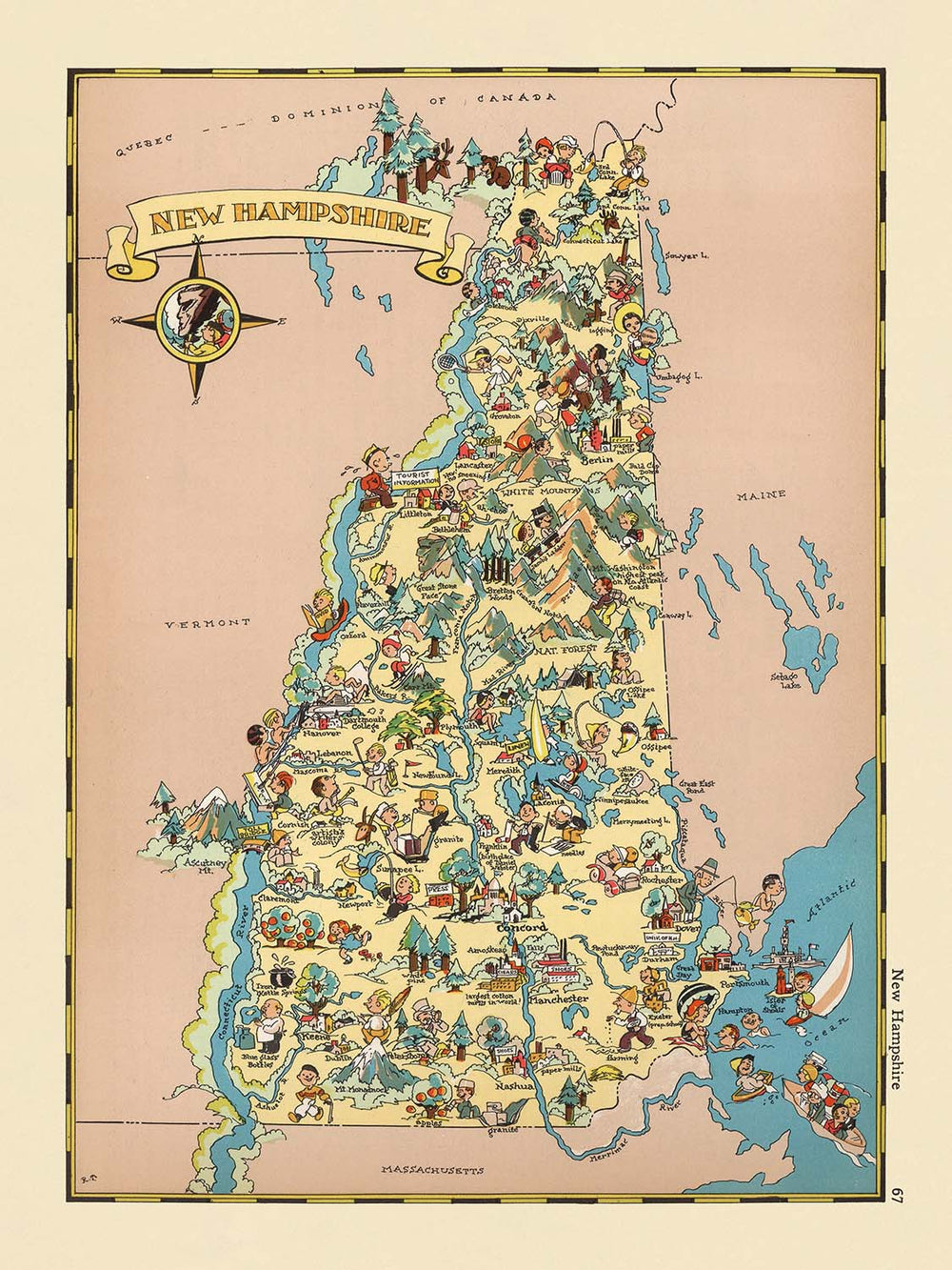


Pictorial Map of New Hampshire by Ruth Taylor White, 1935: Manchester, Nashua, Concord, Lakes, Mountains
20% off 2 — 33% off 3
Add any two eligible items to your bag to receive 20% off. Add a third and it will be complimentary (equivalent to 33% off when purchasing three).
No code needed — the offer applies automatically at checkout.
Valid on all standard maps and fine art prints. You can mix and match any designs.
If you’d like to ship items to multiple addresses, please contact us before placing your order.
Custom and bespoke commissions are excluded.
Contact us if you have any questions
-
![]() Made to order locally in Australia
Made to order locally in Australia

-
Free delivery 2-3 days ⓘ
Free delivery in 2-3 days
Your map should be delivered in 2-3 working days with free delivery, worldwide.
We make maps by hand locally in 23 countries, including Australia
![]() . If you're buying a gift for someone in another country, we will make the map locally to them.
. If you're buying a gift for someone in another country, we will make the map locally to them.You will never pay import tax or customs duty.
Express delivery is available at checkout which can reduce the delivery time to 1-2 days.
Please note that personalised maps, and larger framed maps, can take longer to produce and deliver.
If you need your order to arrive by a certain date, contact me and we can discuss your options.
-
Complimentary gifting & design advice
ⓘ
Complimentary gifting & design advice
Available almost 24/7 on WhatsApp and email — we usually reply within minutes. We can help you:
- Choose a perfectly personalised gift
- Send a digital gift preview to the recipient
- Pick the ideal size for your wall
- Select the right finish and frame
Quick, friendly advice so you can order with confidence.
For last minute gifts, consider buying a digital gift card. We have over 5,000 maps and art prints to choose from.
-
90-day returns & 5-year guarantee
ⓘ
90-day returns & 5-year guarantee
Products can be returned within 90 days for a full refund, or exchange for another product.
We are also proud to offer a 5-year quality guarantee on our maps and art, covering defects in materials or workmanship under normal use.
For personalised and custom made items, we may offer you store credit or a non-expiring gift card, as we cannot resell personalised orders.
If you have any questions, get in touch. For more information, see our full returns & exchanges policy.

This is a museum-grade archival print from the original 1935 map — restored in our workshop and made to order on 220gsm archival matte paper or 400gsm artist's cotton canvas with pigment inks.
Professional framing & free personalisation available.
1. Choose a size
2. Frame & personalise your map
Make your map unique with framing, hand-drawn customisation, vintage ageing, pop art text, unique 3D styling and more.


Gift message & custom finish

If you want to add a gift message, or a finish (jigsaw, aluminium board, etc.) that is not available here, please request it in the "order note" when you check out.
Every order is custom made, so if you need the size adjusted slightly, or printed on an unusual material, just let us know. We've done thousands of custom orders over the years, so there's (almost) nothing we can't manage.
You can also contact us before you order, if you prefer!

- Handmade locally. No import duty or tax
- FREE worldwide delivery
- 90-day returns & 5-year product guarantee
- Questions? WhatsApp me any time
Own a piece of history
7,000+ 5 star reviews


Step into the vibrant world of 1930s New England with “New Hampshire,” the original title of this captivating pictorial map created by Ruth Taylor White in 1935. More than a simple cartographic record, this map is a lively tableau, bursting with color and whimsy, that captures the spirit and character of New Hampshire as it was popularly imagined during the early twentieth century. Each region of the state is brought to life through a delightful array of illustrations, offering a window into the landscapes, industries, and cultural motifs that defined New Hampshire’s identity at the time.
Ruth Taylor White, the talented mapmaker behind this work, was renowned for her distinctive style that merged artistry with cartography. Alongside her husband, Frank J. Taylor, she produced a celebrated series of pictorial maps that combined playful illustration with keen historical and cultural observation. Her work stands out for its accessibility and charm, making geography both engaging and educational. The “New Hampshire” map is a testament to her ability to distill the essence of a place, rendering its forests, lakes, and mountains with both accuracy and imaginative flair.
The design of this map is nothing short of enchanting. Rather than relying on precise topographical detail, White opts for a thematic approach, using vibrant imagery to depict the state’s rugged mountains, sprawling forests, and glistening lakes. Scenes of skiing, hiking, and fishing evoke the state’s reputation as a haven for outdoor enthusiasts, while agricultural vignettes—complete with livestock and maple sugaring—highlight the rhythms of rural life. Covered bridges, colonial churches, and charming homes dot the landscape, evoking the architectural heritage and enduring traditions of New England.
While the map eschews exhaustive textual annotation, its illustrations speak volumes about the historical and cultural context of 1930s New Hampshire. The boundaries of the state are clearly defined, and the counties are subtly delineated, providing a sense of place without overwhelming the viewer with detail. The map also features a constellation of towns and cities—Manchester, Nashua, Concord, and many more—each rendered with a unique flourish that hints at its local character and significance. The absence of national parks or major landmarks does not detract from the map’s allure; instead, it invites viewers to appreciate the state’s natural beauty and vibrant communities as a whole.
Ultimately, this map is a historical artifact as much as it is a work of art. It offers a rare glimpse into how New Hampshire was viewed and celebrated in the American imagination during the 1930s. For collectors, historians, or anyone with a love of New England, Ruth Taylor White’s “New Hampshire” is both a visual delight and a cultural treasure—an evocative reminder of a bygone era, rendered with warmth, wit, and unmistakable style.
Cities and towns on this map
- Manchester
- Nashua
- Concord
- Derry
- Rochester
- Salem
- Dover
- Merrimack
- Londonderry
- Hudson
- Keene
- Portsmouth
- Bedford
- Goffstown
- Laconia
- Claremont
- Lebanon
- Somersworth
- Durham
- Exeter
- Hanover
- Windham
- Amherst
- Milford
- Raymond
- Hooksett
- Berlin
- Conway
- Franklin
- Newport
Notable Features & Landmarks
- Colorful illustrations of forests and mountains, representing the state's natural landscape
- Depictions of people engaged in outdoor activities such as skiing, hiking, and fishing
- Illustrations of farming and agricultural scenes, including livestock and crops
- Drawings of lakes and rivers, emphasizing New Hampshire's water features
- Imagery of covered bridges, a traditional architectural feature in the state
- Pictorial representations of the state's industries, such as logging and textile production
- Artistic renderings of wildlife native to New Hampshire, such as deer and fish
- Illustrations of maple sugaring, a traditional New Hampshire activity
- Visual motifs of New England culture, including colonial-style homes and churches
- The state border is clearly delineated, with neighboring states faintly indicated
- County boundaries are marked, but not labeled with county names
Historical and design context
- Original title: New Hampshire (1935)
- Mapmaker: Ruth Taylor White, known for her distinctive pictorial cartographic style
- The map is a County or State Thematic and Pictorial map, part of a larger series of U.S. state maps
- Artistic style is highly pictorial and cartoon-like, focusing on visual storytelling rather than geographic precision
- The map provides insight into how New Hampshire was popularly perceived in the 1930s, reflecting social and cultural attitudes of the time
- Illustrations serve as a visual snapshot of the era, capturing both the natural beauty and economic activities of New Hampshire
- The map is notable for its use of vibrant colors and stylized figures to represent people, animals, and activities
Please double check the images to make sure that a specific town or place is shown on this map. You can also get in touch and ask us to check the map for you.
This map looks great at every size, but I always recommend going for a larger size if you have space. That way you can easily make out all of the details.
This map looks amazing at sizes all the way up to 50in (125cm). If you are looking for a larger map, please get in touch.
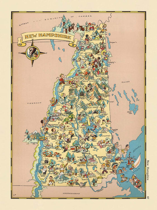
The model in the listing images is holding the 18x24in (45x60cm) version of this map.
The fifth listing image shows an example of my map personalisation service.
If you’re looking for something slightly different, check out my collection of the best old maps to see if something else catches your eye.
Please contact me to check if a certain location, landmark or feature is shown on this map.
This would make a wonderful birthday, Christmas, Father's Day, work leaving, anniversary or housewarming gift for someone from the areas covered by this map.
This map is available as a giclée print on acid free archival matte paper, or you can buy it framed. The frame is a nice, simple black frame that suits most aesthetics. Please get in touch if you'd like a different frame colour or material. My frames are glazed with super-clear museum-grade acrylic (perspex/acrylite), which is significantly less reflective than glass, safer, and will always arrive in perfect condition.
This map is also available as a float framed canvas, sometimes known as a shadow gap framed canvas or canvas floater. The map is printed on artist's cotton canvas and then stretched over a handmade box frame. We then "float" the canvas inside a wooden frame, which is available in a range of colours (black, dark brown, oak, antique gold and white). This is a wonderful way to present a map without glazing in front. See some examples of float framed canvas maps and explore the differences between my different finishes.
For something truly unique, this map is also available in "Unique 3D", our trademarked process that dramatically transforms the map so that it has a wonderful sense of depth. We combine the original map with detailed topography and elevation data, so that mountains and the terrain really "pop". For more info and examples of 3D maps, check my Unique 3D page.
For most orders, delivery time is about 3 working days. Personalised and customised products take longer, as I have to do the personalisation and send it to you for approval, which usually takes 1 or 2 days.
Please note that very large framed orders usually take longer to make and deliver.
If you need your order to arrive by a certain date, please contact me before you order so that we can find the best way of making sure you get your order in time.
I print and frame maps and artwork in 23 countries around the world. This means your order will be made locally, which cuts down on delivery time and ensures that it won't be damaged during delivery. You'll never pay customs or import duty, and we'll put less CO2 into the air.
All of my maps and art prints are well packaged and sent in a rugged tube if unframed, or surrounded by foam if framed.
I try to send out all orders within 1 or 2 days of receiving your order, though some products (like face masks, mugs and tote bags) can take longer to make.
If you select Express Delivery at checkout your order we will prioritise your order and send it out by 1-day courier (Fedex, DHL, UPS, Parcelforce).
Next Day delivery is also available in some countries (US, UK, Singapore, UAE) but please try to order early in the day so that we can get it sent out on time.
My standard frame is a gallery style black ash hardwood frame. It is simple and quite modern looking. My standard frame is around 20mm (0.8in) wide.
I use super-clear acrylic (perspex/acrylite) for the frame glass. It's lighter and safer than glass - and it looks better, as the reflectivity is lower.
Six standard frame colours are available for free (black, dark brown, dark grey, oak, white and antique gold). Custom framing and mounting/matting is available if you're looking for something else.
Most maps, art and illustrations are also available as a framed canvas. We use matte (not shiny) cotton canvas, stretch it over a sustainably sourced box wood frame, and then 'float' the piece within a wood frame. The end result is quite beautiful, and there's no glazing to get in the way.
All frames are provided "ready to hang", with either a string or brackets on the back. Very large frames will have heavy duty hanging plates and/or a mounting baton. If you have any questions, please get in touch.
See some examples of my framed maps and framed canvas maps.
Alternatively, I can also supply old maps and artwork on canvas, foam board, cotton rag and other materials.
If you want to frame your map or artwork yourself, please read my size guide first.
My maps are extremely high quality reproductions of original maps.
I source original, rare maps from libraries, auction houses and private collections around the world, restore them at my London workshop, and then use specialist giclée inks and printers to create beautiful maps that look even better than the original.
My maps are printed on acid-free archival matte (not glossy) paper that feels very high quality and almost like card. In technical terms the paper weight/thickness is 10mil/200gsm. It's perfect for framing.
I print with Epson ultrachrome giclée UV fade resistant pigment inks - some of the best inks you can find.
I can also make maps on canvas, cotton rag and other exotic materials.
Learn more about The Unique Maps Co.
Map personalisation
If you're looking for the perfect anniversary or housewarming gift, I can personalise your map to make it truly unique. For example, I can add a short message, or highlight an important location, or add your family's coat of arms.
The options are almost infinite. Please see my map personalisation page for some wonderful examples of what's possible.
To order a personalised map, select "personalise your map" before adding it to your basket.
Get in touch if you're looking for more complex customisations and personalisations.
Map ageing
I have been asked hundreds of times over the years by customers if they could buy a map that looks even older.
Well, now you can, by selecting Aged before you add a map to your basket.
All the product photos you see on this page show the map in its Original form. This is what the map looks like today.
If you select Aged, I will age your map by hand, using a special and unique process developed through years of studying old maps, talking to researchers to understand the chemistry of aging paper, and of course... lots of practice!
If you're unsure, stick to the Original colour of the map. If you want something a bit darker and older looking, go for Aged.
If you are not happy with your order for any reason, contact me and I'll get it fixed ASAP, free of charge. Please see my returns and refund policy for more information.
I am very confident you will like your restored map or art print. I have been doing this since 1984. I'm a 5-star Etsy seller. I have sold tens of thousands of maps and art prints and have over 5,000 real 5-star reviews. My work has been featured in interior design magazines, on the BBC, and on the walls of dozens of 5-star hotels.
I use a unique process to restore maps and artwork that is massively time consuming and labour intensive. Hunting down the original maps and illustrations can take months. I use state of the art and eye-wateringly expensive technology to scan and restore them. As a result, I guarantee my maps and art prints are a cut above the rest. I stand by my products and will always make sure you're 100% happy with what you receive.
Almost all of my maps and art prints look amazing at large sizes (200cm, 6.5ft+) and I can frame and deliver them to you as well, via special oversized courier. Contact me to discuss your specific needs.
Or try searching for something!


