


Rare Old OS Map of Mallaig, Inverness-shire by Bartholomew, 1901: Isle of Skye, Loch Morar, Cuillin Hills, Glenfinnan, Sound of Sleat, Knoydart

-
FREE delivery in 2 to 3 days
Free delivery in 2 to 3 days
Your map should be delivered in 2 to 3 working days with free delivery, worldwide.
We make maps by hand locally in 23 countries, including Australia
![]() . If you're buying a gift for someone in another country, we will make the map locally to them.
. If you're buying a gift for someone in another country, we will make the map locally to them.You will never pay import tax or customs duty.
Free delivery will gradually get slower towards Christmas, as postal services start to struggle with larger volumes of post. I recommend ordering sooner rather than later to make sure you get everything with time to spare. Check my Christmas delivery guide for more info.
Express delivery is available at checkout which can reduce the delivery time to 1-2 days.
Please note that personalised maps, and larger framed maps, can take longer to produce and deliver.
If you need your order to arrive by a certain date, contact me and we can discuss your options.
-
Certified sustainable +
we plant trees🌳
Sustainability & Tree Planting
Here at The Unique Maps Co., we have an unusually high affinity for paper. After all, without paper, there can be no maps!
That's why all of our paper, frames and packaging are from FSC certified sources.
But we don't stop there. We've partnered with Treeapp to plant trees around the world.
If you spend $90 or more, we'll plant a tree in your name.
- Framing & personalisation available
-
60 day money back guarantee
60 days to return and refund
Products can be returned within 60 days for a full refund, or exchange for another product.
Our usual returns window is 30 days, but to give you extra peace of mind during the Christmas period, we have an extended returns period of 60 days.
For personalised and customised items, we may offer you a non-expiring gift card, as we cannot resell personalised orders.
If you have any questions, get in touch. For more information, see our full returns & exchanges policy.
My maps are rare, museum-grade, restored old maps sourced from libraries, auction houses and private collections across the globe.
Custom size and finish

If you are looking for a size or finish that is not available here, please request it in the "order note" when you check out.
Every order is custom made, so if you need the size adjusted slightly, or printed on an unusual material, just let us know. We've done thousands of custom orders over the years, so there's (almost) nothing we can't manage.
You can also contact us before you order, if you prefer!
Sheet 14 - Mallaig, a masterful creation by the illustrious JG Bartholomew in 1901, stands as a testament to the golden age of cartography. Bartholomew, often hailed as the "Prince of Cartography," was renowned for his meticulous attention to detail and innovative design. This map, part of Bartholomew's flagship series, is a striking example of his work, offering a half-inch to the mile scale (1:126,720) that captures the essence of the Mallaig region in Scotland. The map's clarity and attractiveness made it a favorite among cyclists and tourists of the early 20th century, providing them with a reliable and aesthetically pleasing guide to the rugged Scottish landscape.
The map's design is both functional and beautiful, employing a subtle gradation of color bands to represent landscape relief. This innovative technique allows users to easily discern the varying heights of the terrain, from the towering Cuillin Hills on the Isle of Skye to the serene waters of Loch Morar. The careful use of color not only enhances the map's visual appeal but also provides a practical tool for navigating the diverse topography of the region. The map's detailed depiction of both political boundaries and physical landscapes offers a comprehensive view of the area, making it an invaluable resource for anyone interested in the geography of early 20th century Scotland.
This map covers a vast area, stretching 36 miles from north to south and 52 miles from west to east, encompassing the picturesque Inner Hebrides and the dramatic west coast of the Scottish Highlands. The map includes notable features such as the Sound of Sleat, Loch Nevis, and the Knoydart Peninsula, each rendered with precision and care. The islands of Rum, Eigg, and Muck are also prominently featured, their rugged landscapes captured in exquisite detail. The map's coverage of these regions provides a fascinating glimpse into the natural beauty and geographical diversity of Scotland.
In addition to its physical features, the map also highlights several historical landmarks, such as the Glenfinnan Monument near Loch Shiel. This monument, commemorating the Jacobite Rising of 1745, adds a layer of historical significance to the map, connecting the viewer to the rich cultural heritage of the region. The map's inclusion of such landmarks underscores Bartholomew's commitment to creating maps that are not only geographically accurate but also culturally informative. This attention to historical context makes the map a valuable artifact for historians and enthusiasts alike.
The towns and settlements depicted on the map, including Mallaig, Arisaig, and Glenfinnan, offer a snapshot of the human geography of the time. These towns, nestled amidst the dramatic landscapes of the Highlands and islands, provide a sense of the region's inhabited spaces and their relationship to the surrounding natural environment. The map's detailed portrayal of these settlements, along with their political divisions, offers a comprehensive view of the area's human geography. This combination of physical and human geography, rendered with Bartholomew's characteristic precision and artistry, makes Sheet 14 - Mallaig a truly remarkable piece of cartographic history.
Cities and towns on this map
- Inverness-shire:
- Mallaig
- Arisaig
- Morar
- Glenfinnan
- Lochailort
- Inverie
- Acharacle
- Kilchoan
-
Strontian
-
Ross and Cromarty:
- Kyle of Lochalsh
- Plockton
- Dornie
-
Lochcarron
-
Isle of Skye (southern parts)
- Broadford
- Glenelg
Notable Features & Landmarks
- Physical Features:
- Loch Morar
- Loch Nevis
- Sound of Sleat
- Isle of Skye
- Isle of Rum
- Isle of Eigg
- Isle of Muck
- Cuillin Hills
- Knoydart Peninsula
- Loch Hourn
- Loch Duich
- Loch Alsh
- Loch Long
-
Loch Shiel
-
Historical Landmarks:
- Glenfinnan Monument (near Loch Shiel)
Historical and design context
- Mapmaker or publisher: JG Bartholomew, often referred to as the "Prince of Cartography."
- Scale and dimensions: Half-inch to the mile scale (1:126,720). Covers 36 miles from north to south, and 52 miles from west to east.
- Date of creation: 1901
- Themes and topics shown on the map:
- Political and physical features: The map details both political boundaries and physical landscapes.
- Landscape relief: Utilizes different layers of color to represent landscape relief, with a gradation of color bands showing land at different heights.
- Design and style: The map is clear, attractive, and colorful, making it popular among cyclists and tourists. It is based on a reduced Ordnance Survey map from the same period.
- Historical significance: These maps became Bartholomew's flagship series, known for their clarity and innovative design. They provide valuable historical insight into the geography and political boundaries of early 20th century Scotland.
Please double check the images to make sure that a specific town or place is shown on this map. You can also get in touch and ask us to check the map for you.
This map looks great at every size, but I always recommend going for a larger size if you have space. That way you can easily make out all of the details.
This map looks amazing at sizes all the way up to 70in (180cm). If you are looking for a larger map, please get in touch.
Please note: the labels on this map are hard to read if you order a map that is 20in (50cm) or smaller. The map is still very attractive, but if you would like to read the map easily, please buy a larger size.
The model in the listing images is holding the 16x20in (40x50cm) version of this map.
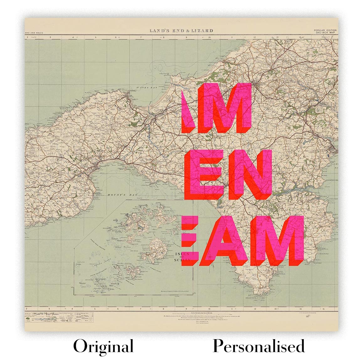
The fifth listing image shows an example of my map personalisation service.
If you’re looking for something slightly different, check out my collection of the best old maps to see if something else catches your eye.
Please contact me to check if a certain location, landmark or feature is shown on this map.
This would make a wonderful birthday, Christmas, Father's Day, work leaving, anniversary or housewarming gift for someone from the areas covered by this map.
This map is available as a giclée print on acid free archival matte paper, or you can buy it framed. The frame is a nice, simple black frame that suits most aesthetics. Please get in touch if you'd like a different frame colour or material. My frames are glazed with super-clear museum-grade acrylic (perspex/acrylite), which is significantly less reflective than glass, safer, and will always arrive in perfect condition.
For most orders, delivery time is about 3 working days. Personalised and custom made maps take longer, as I have to do the personalisation and send it to you for approval, which usually takes a day or two.
Please note that for larger framed orders (over 40in/100cm), and some other framed sizes, the delivery time will be closer to 7-10 days.
If you need your order to arrive by a certain date, please contact me before you order so that we can find the best way of making sure you get your order in time.
I print and frame maps in 22 countries around the world. This means your map will be made locally, which cuts down on delivery time and reduces the chance of your map being damaged during delivery. There won't be any extra taxes or duties to pay, and we'll put less CO2 into the air.
All of my maps are well packaged and sent in a rugged tube if unframed, or surrounded by foam if framed.
I try to send out all maps within 1 or 2 days of receiving your order, though some products (like face masks or mugs) can take longer to make.
If you select Express Delivery at checkout your order we will prioritise your order and send it out by 1-day courier (Fedex, DHL, UPS, Parcelforce).
We can sometimes do next-day delivery if you order before 10am. But usually it's best to contact me first before you order.
My standard frame is a gallery style black ash hardwood frame. It is simple and quite modern looking. My standard frame is around 20mm (0.8in) wide.
I use super-clear acrylic (perspex/acrylite) for the frame glass. It's lighter and safer than glass - and it looks better, as the reflectivity is lower.
Six standard frame colours are available for free (black, dark brown, dark grey, oak, white and antique gold). Custom framing and mounting/matting is available if you're looking for something else.
Most maps are also available as a framed canvas. The map is printed on matte (not shiny) canvas, stretched over a box frame, and then 'floated' within a simple wood frame. The end result is quite beautiful, and there's no glazing in front of your map.
All frames are provided "ready to hang", with either a string or brackets on the back. Very large frames will have heavy duty hanging plates and/or a mounting baton. If you have any questions, please get in touch.
See some examples of my framed maps and framed canvas maps.
Alternatively, I can also supply old maps on canvas, foam board, cotton rag and other materials.
If you want to frame your map yourself, please read my map size guide first.


My maps are extremely high quality reproductions of original maps.
I source original, rare maps from libraries, auction houses and private collections around the world, restore them at my London workshop, and then use specialist giclée inks and printers to create beautiful maps that look even better than the original.
My maps are printed on acid-free archival matte (not glossy) paper that feels very high quality and almost like card. In technical terms the paper weight/thickness is 10mil/200gsm. It's perfect for framing.
I print with Epson ultrachrome giclée UV fade resistant pigment inks - some of the best inks you can find.
I can also make maps on canvas, cotton rag and other exotic materials.
Learn more about The Unique Maps Co.
Map personalisation
If you're looking for the perfect anniversary or housewarming gift, I can personalise your map to make it truly unique. For example, I can add a short message, or highlight an important location, or add your family's coat of arms.
The options are almost infinite. Please see my map personalisation page for some wonderful examples of what's possible.
To order a personalised map, select "personalise your map" before adding it to your basket.
Get in touch if you're looking for more complex customisations and personalisations.
Map ageing
I have been asked hundreds of times over the years by customers if they could buy a map that looks even older.
Well, now you can, by selecting Aged before you add a map to your basket.
All the product photos you see on this page show the map in its Original form. This is what the map looks like today.
If you select Aged, I will age your map by hand, using a special and unique process developed through years of studying old maps, talking to researchers to understand the chemistry of aging paper, and of course... lots of practice!
If you're unsure, stick to the Original colour of the map. If you want something a bit darker and older looking, go for Aged.
If you are not happy with your unique map for any reason, contact me for a no-quibble refund.
I am very confident you will like your old map. I have been doing this since 1984. I'm a 5-star Etsy seller. I have sold tens of thousands of maps and have over 4,000 real 5-star reviews.
I use a unique process to restore my maps that is massively time consuming and labour intensive. Hunting down the original maps can take months. I use state of the art and eye-wateringly expensive technology to scan and restore the maps. As a result, I guarantee my maps are a cut above the rest - that's why I can offer a no-quibble refund.
Almost all of my maps look amazing at large sizes (200cm, 6.5ft+) and I can frame and deliver them to you as well, via special oversized courier. Contact me to discuss your specific needs.
Or try searching for something!


